

cbmclean
-
Posts
3,057 -
Joined
-
Last visited
Content Type
Profiles
Blogs
Forums
American Weather
Media Demo
Store
Gallery
Posts posted by cbmclean
-
-
9 minutes ago, brooklynwx99 said:
just so people understand how absurd modeling is getting for mid-late month, this is the GEPS through 300. insane amounts of snow
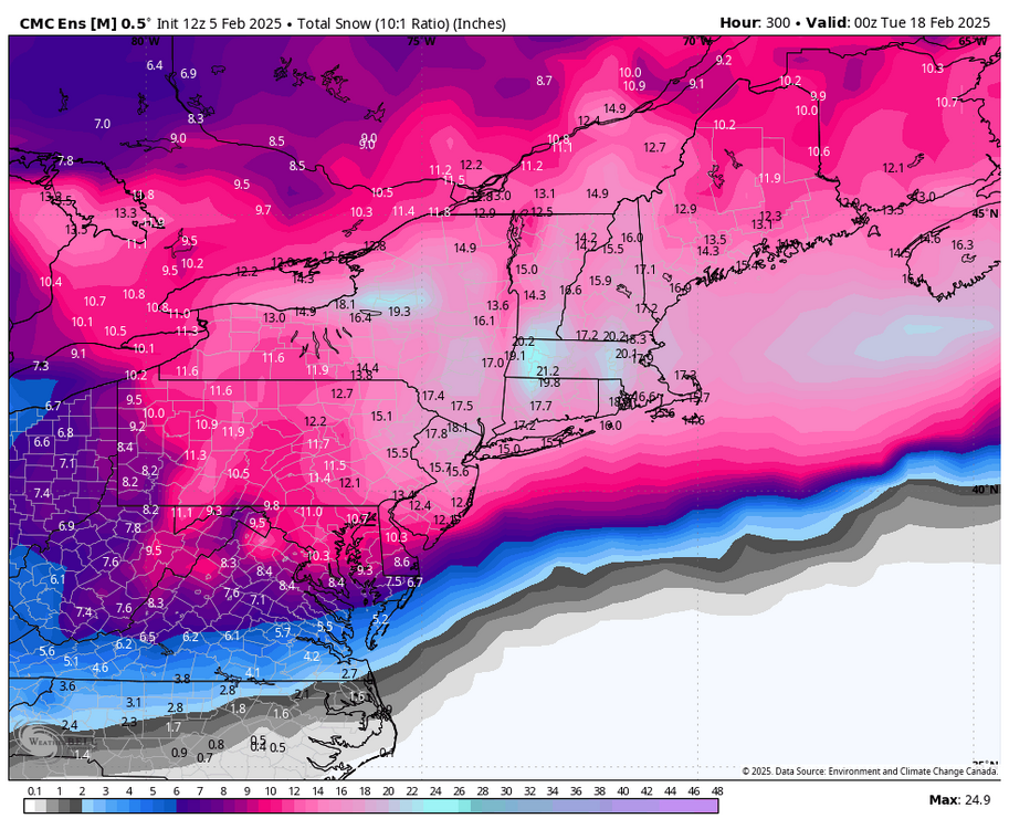
this is the pattern during that snowfall mean. not after the block breaks down, which is when you'd probably get your largest storm. it's beyond lmao
This is the PSU Pattern. For every inch of snow you guys get during it, he gets a 10% cut.
-
23 minutes ago, Terpeast said:
Looking ahead on the overall pattern including the EPO, the GEFS has actually been doing better in the last 2 weeks and should be the favored model until verification scores flip.
Wait, what? Wasn't the GEFS confidently showing a +600000 dm SER until less than a week ago? Chuck may have posted about it once or twice.
ETA: And also missing the -EPO pattern?
-
13 minutes ago, Maestrobjwa said:
They do? How about a shout out for us Baltimoreans

The Wire was a good show.
-
 1
1
-
-
1 minute ago, aldie 22 said:
Where is the money on who panics first after the next crappy model run?
Ji pays out at 1:1000,
-
10 minutes ago, Ji said:
Jb said Ai cancelled the cold pattern for mid February
This has been an odd year, BAM and Eric Webb have often been on the cold hype train; while JB has been a downer. Next we'll see dogs and cats living together; mass hysteria!!
-
 1
1
-
-
The 2/13 wave is of little interest to me at this point but I am intrigued by some of the looks showing up after that. It takes a lot to get good stuff east of RDU in late Feb especially in the warmer base state, but I got a solid 2 - 3" back in late Feb 2020, which was a miserable +++AO torch year overall.
-
Starting to see some comparisons to the Feb 2018 SSWE which apparently was rather sudden and unexpected. At this point though, do we really want a SSWE? Seems like things are coming together nicely with a split PV with a piece trapped on our side. SSWE's are like throwing a grenade in the pattern and hoping for the best.
-
The prognosticated pattern improvement, if it verifies, seems to be setting up about 2 weeks too late for legitimate hopes for RDU east. That said some pretty anomalous solutions starting to show up on some guidance, so I'll stay interested for a while yet
-
2
-
-
NC climate sites summary from January from the NWS shows Raleigh only -3.1 F for the month while Gboro was -4.9 and Fayetteville was -5.1. RDU was only 0.2 colder than Fay overall and actually 0.6 warmer for mean minimum.
-
56 minutes ago, CAPE said:
A -PDO definitely tends to mitigate the impacts of an el Nino. Probably more so in our current regime.
But the way in which a -PDO screws with a nino is by favoring + height anomalies in east, counteracting the nino propensity to drive a trough their, right?
-
1 hour ago, CAPE said:
Here ya go. SER wasn't an issue.

I could have sworn SER made some appearances last year in between Pac Puke episodes. I guess to clarify when I speak of the "SER" I am including the -PDO propensity for heights to spike to the North Pole in front of every short wave. Maybe that is a different animal from a stable bermuda ridge.
-
4 minutes ago, Maestrobjwa said:
The SER wasn't last year--I think you're thinking about the year before.
The SER definitely made multiple appearances last year. It and Pack Puke basically took turns crushing our dreams
-
2 minutes ago, Maestrobjwa said:
As modeled this would be a better split than we've had in recent years...not all splits are created equal! It's like hitting a gel pack with a hammer...how the gel inside splits depends on where ya hit it! A couple years ago I think it split to the middle of the country. Other times it could split to the other side of the globe like 2022-23 (I think that was the year) @psuhoffman Let me know if I'm off base on any of that!
Yes I was aware of the mercurial nature of SPV collapses (aka SSW events), just not as familiar with splits.
-
1 minute ago, psuhoffman said:
They typically coincide with a period of -AO
Then sign me up for splitsville!
-
5 minutes ago, Heisy said:


Speaking of good splits
.What, if anything, are the potential implications for an SPV split in terms of sensible weather? I'm not really familiar with split PVs.
-
5 hours ago, WxUSAF said:
I like big splits and I can not lie
You other weenies can’t deny
When the strat walks in with an ittybitty waist and a round thing in your face
You get COLD!
So does a split stratospheric PV mean anything for the lower troposphere?
-
I will also note that not all of the GEFS members are that explosive into 6, with a sizeable number looking like the Euro. I wonder if the ensemble mean is being significantly skewed by the camp which is predicting explosion.
-
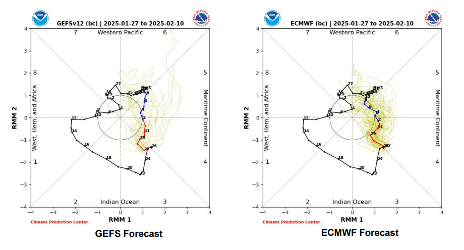
As Weather Will noted, GEF apesh!t SER likely stems from explosive intensification of the MJO into Phase 6 with one member bursting through the roof and apparently causing the world to incinerate. The EPS is much more restrained with a general prediction of progression through 6 into 7. We really want to get back to 8 to tart feeling better.
-
3
-
-
22 minutes ago, Ralph Wiggum said:
Gorgeous Bermuda high as depicted. Shorts and tee shirt weather.
I protest at the use of the word "gorgeous" to describe a Bermuda High in winter.
-
1
-
2
-
-
30 minutes ago, RickinBaltimore said:
Every other team in the NBA has won at least 50+ games in a season since 1979. It's almost a half-century of meh/bad basketball.
Well you did have that glorious but brief Gheorghe Mureșan era. Seriously though I liked watching him play. He had some talent.
-
So a warm period the first week of Feb looks highly likely barring some major modeling collapse (wouldn't it be nice if the warm pattern collapsed like last years epic pattern collapsed?) Looks like the crystal ball is very murky after that. As @psuhoffman has pointed out, historical analogs say a flip back to cold would be expected by the end of February into March. The real question as I see it is what happens the period of say Feb 10 - 24.
-
1 hour ago, CAPE said:


The GFS appears to be firmly in the camp of a longer tour through the bad phases of the MJO. May be contributing to that enhanced SER look.
-
10 minutes ago, Terpeast said:
Western ridging trending stronger at 360 va previous runs. Still need to keep an eye on the AK ridge and how that also trends. Looks to me the SE ridge end of run is more transient for now
I would call it more less troughing in the west. Still I'd rather have it go that way than the other.
I tried to embed a trend GIF but it wouldn't work for me. I've seen people do it before. How do you do it?
-
Just now, frd said:
I imagine that configuration helps guide colder air towards our area, and may have a role with the PV being on our side of the NH.
I have not heard of any SSW events, but we do not need them the way the Pac has been cooperating.
The 10 HP winds are actually very strong this year or so I have heard, so no SSWs in the offing. As many have observed they are a crapshoot at best and absolutely undesirable with a good longwave pattern.
-
1
-


February Medium/Long Range Thread
in Mid Atlantic
Posted
Pretty up top, but I want to see that SER beat down.