

cbmclean
-
Posts
3,062 -
Joined
-
Last visited
Content Type
Profiles
Blogs
Forums
American Weather
Media Demo
Store
Gallery
Posts posted by cbmclean
-
-
So a warm period the first week of Feb looks highly likely barring some major modeling collapse (wouldn't it be nice if the warm pattern collapsed like last years epic pattern collapsed?) Looks like the crystal ball is very murky after that. As @psuhoffman has pointed out, historical analogs say a flip back to cold would be expected by the end of February into March. The real question as I see it is what happens the period of say Feb 10 - 24.
-
1 hour ago, CAPE said:


The GFS appears to be firmly in the camp of a longer tour through the bad phases of the MJO. May be contributing to that enhanced SER look.
-
10 minutes ago, Terpeast said:
Western ridging trending stronger at 360 va previous runs. Still need to keep an eye on the AK ridge and how that also trends. Looks to me the SE ridge end of run is more transient for now
I would call it more less troughing in the west. Still I'd rather have it go that way than the other.
I tried to embed a trend GIF but it wouldn't work for me. I've seen people do it before. How do you do it?
-
Just now, frd said:
I imagine that configuration helps guide colder air towards our area, and may have a role with the PV being on our side of the NH.
I have not heard of any SSW events, but we do not need them the way the Pac has been cooperating.
The 10 HP winds are actually very strong this year or so I have heard, so no SSWs in the offing. As many have observed they are a crapshoot at best and absolutely undesirable with a good longwave pattern.
-
 1
1
-
-
1 hour ago, Ralph Wiggum said:
Happy Anniversay to those who celebrate. Can't believe it has been a quarter century!
https://en.m.wikipedia.org/wiki/January_2000_North_American_blizzard
I remember watching the models 48 hours prior. I believe we had the MRF, it's sister "high res" avn that went to 72(?), the ETA to 48, and the NGM. All models iirc had a low racing ENE off the GA/SC Coast. I remember particularly seeing the ETA the morning of the 24th had the low stronger, much stronger, but was still well ots. Then 12z on the 24th closer. Then next run closer and a coastal grazing.
No model I dont think had it until it happened. We were on mirc #neweather chat....me, randy iirc, Marcus, ian....we were watching the radar at 0z and saying it didn't match the models. And it was on!!
What a memorable event! Had around a foot where I'm at but we sleeted and dry slotted as it exploded and occluded.
That event is fondly remembered in my sub for obvious reasons.
-
1
-
-
21 minutes ago, psuhoffman said:
but which normals are they using?????
The upcoming 2030 - 2060 base period. -10 F equates to 60 F.
-
 1
1
-
 2
2
-
-
2 minutes ago, mitchnick said:
Did you really expect it to hold? Runs like that at 10 days never do. In fact, runs like that at any range hardly ever hold.
Are you familiar with Ji?
-
2
-
1
-
-
14 minutes ago, BornAgain13 said:
18z GFS with a big snow/ice storm at Day 10. Several runs in a row showing a winter storm.
I'm not sure I can handle another emotional roller coaster. If it's still there in 5 days I'll get invested.
-
2 hours ago, donsutherland1 said:
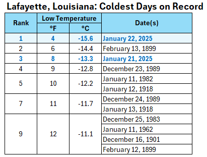
When you outdo a day in Feb 1899 for cold, you have made an accomplishment.
-
3
-
1
-
-
2 hours ago, psuhoffman said:
Let see what the impact is when the pdo is positive.
Would you expect the PDO to impact the jet? I thought that was an independent problem due to the Hadley cell expansion.
-
22 minutes ago, Terpeast said:
I was just thinking about this when bluewave kept mentioning the stronger pac jet.
We saw the same last year when the pac jet verified stronger than forecast, and that actually hurt us in a nino by flooding the continent with mild pacific air almost the whole winter. Only when it relaxed a bit did we get a snowy week in Jan here.
Now this time, the stronger pac jet is helping us because were not in a nino (cold enso/weak nina). In the long range, the models keep trying to weaken the jet and bring the PNA ridge west towards the aleutians. Then it all shifts east as it gets closer in time.
I'm glad that is helping the cause this year, but it doesn't bode well for chances of getting a nice clean miller A in future Ninos if that Pac Jet stays permanently jacked up. I'm hoping it collapses...just wait til the end of this winter first
 .
.
-
1
-
-
2 minutes ago, PackGrad05 said:
Really nice band setting up along I-95 from Florence to Fayetteville.. moving north.
Where do you view radar?
-
14 minutes ago, Fozz said:
Forecasts are now calling for 4-6” for most of the panhandle and as far as I’m aware, 4” is the all time record for Florida. And there’s already an unconfirmed report of 5” in the area.
They are in uncharted territory now.
-
52 minutes ago, MHCWEATHER said:
We’re probably distantly related. I’m a McLean, and my grandfather’s clan is generally from Gray’s Creek

I'm glad to see you spell it right!!
-
 1
1
-
-
So some years ago I thought the whole notion of "the models will change when the storm gets better sampled over land" was ridiculed into oblivion along with the "18Z models are trash" myth. I was told that the vast majority of model ingestion is from satellite soundings and that RAOBs were of much reduced importance. Now I'm hearing this idea being resurrected all over the place by people who seem to know what they are talking bout. So which is it?
-
5 minutes ago, snowinnc said:
Very cool! I went to Fayetteville Academy. I always hear people call it the Academy, but that just sounds so uppity to me.
Ah you're one of those types. Just Kidding. I vividly remember the dreaded snowline between Raleigh and Fayetteville from my childhood as well. When I moved to Greensboro for college I remember reveling in the marginal events that were snow there and rain back home.
-
1
-
-
17 minutes ago, pazzo83 said:
I guess one of the big differences is if you look at the arctic outbreaks from 30 years ago (mid 1990s), you saw air temps in the -30s and -40s in the upper plains states and widespread subzero readings along the coastal plain in the east. Just doesn't seem to have the same punch (although it's time perfectly with a storm in the gulf to give them a rare snowstorm).
Not disputing your basic point, but there were widespread -30s and I believe some -40s in the 2021 outbreak in the Midwest. Of course the east coast was completely shielded from that outbreak by our beloved friend, the SER.
-
1
-
-
4 minutes ago, snowinnc said:
If Fayetteville really gets 1”-3” of snow, that’s going to make me happy. Growing up there and going to school in 34 degree rain while Raleigh kids had snow days really ticked me off. After we moved to North Raleigh, I thought we would be enjoying the snow I saw from afar growing up, but no, we get no snow!
Hey, which High School did you go to? I'm from Hope Mills.
-
3 minutes ago, NorthHillsWx said:
An inch would be epic to me at this point
Agreed. It would be about 0.9" more than I have seen in the last three tears combined..
-
1
-
-
6 minutes ago, NorthHillsWx said:
MAYBE we gave up just a little early….
DON'T GET SUCKED BACK IN!! They're just toying with us.
-
5
-
1
-
-
6 minutes ago, Fozz said:
The GFS is showing up to 5-6” of snow on the Florida panhandle, just 2 days from now.
This isn’t fantasy range anymore.
Would that be an all time record for the state if it happened?
I believe their record is 4" back in March 1954. Must have been an anomalous pattern.
-
1
-
-
GFS and ICON both show Teeny-Tiny NW trends, but only in the N extent of the moisture, very little change in track. At this point it is far too little, too late. for inland folks in the Carolinas.
-
1
-
1
-
-
1 minute ago, GaWx said:
0Z ICON continues the general trend of this model moistening up in NW FL as well as in the GA/SC coastal areas:
0Z Icon qpf

0Z Icon 10:1 snow

Icon snow from 24 hours ago:

Only need about 400 hundred more model cycles of this NW trend and Central NC will be back in the game!! Icon and FV3 starting an unstoppable trend going from .001 qpf to .01 qpf.
-
4
-
-
1 minute ago, Thrasher Fan said:
I predict they get on board soon. As per usual, the mid/long range outlook on the extreme cold (and heat in the summer) is moderating out thus the base of the trough not digging as far south as earlier modeled.
It will still be extremely cold. Just not extremely extreme.
-
1
-


January Banter 2025
in Mid Atlantic
Posted
Well you did have that glorious but brief Gheorghe Mureșan era. Seriously though I liked watching him play. He had some talent.