

cbmclean
-
Posts
2,590 -
Joined
-
Last visited
Content Type
Profiles
Blogs
Forums
American Weather
Media Demo
Store
Gallery
Posts posted by cbmclean
-
-
I haven't taken a look at the MJO prog's today. Still stalling in 8 or making a move towards 1?
-
8 minutes ago, psuhoffman said:
I think we are too quick to label things we don’t understand stochastic.
A valid point. On the other hand though, I also think that when phenomena are difficult to understand it is a great temptation to do a knee-jerk grab at some simple causation. But it seems that whenever a forecast does not turn out the way that we expect we want to pull another index out of our hat as an explanation. I am just as guilty as anyone else: NAO, AO, PNA, EPO, ENSO, SOI, PDO, AMO, QBO and now I guess the TNH.
-
15 minutes ago, psuhoffman said:
Physics dictates it has a cause. Just because we don’t understand the cause doesn’t make it random. The cause might be something we lack the ability to measure or even comprehend but it has a cause.
Also, whenever we start talking about cause an effect, we always run into the causation chain problem: what causes the cause? For example, above you mentioned the MJO and ENSO as drivers. But something has to drive them right? I know that a lot of research ink has been spent looking into the hows and whys of ENSO. I for one am being driven crazy by the ineffability of the MJO. Why is it strong some times and weak others? Why does it move fast or slow? Why does it sometime do loop-de-loops.
I'm not trying to be pointlessly argumentative. I just have so much desire to understand, and so little knowledge.
-
2 minutes ago, psuhoffman said:
Physics dictates it has a cause.
While this statement seems intuitive, it is by no means universally agreed upon by scientists and philosophers. Some physical processes may not be causal in the way that we understand. Take radioactive beta decay for an example. We can define with great precision the probability that any given atom will spontaneously decay, but explaining why this atom decays as opposed to the one next to it is a different matter.
I'm not just rolling or being silly. I actually think it is a great philosophical point to ponder.
-
39 minutes ago, psuhoffman said:
We are obviously in a +TNH pattern BUT I never understood it to be a pattern causation. I thought it was just like the pna, epo, wpo, NAO.... a measure of the pattern. Not something that caused the pattern like the mjo, enso, soi, solar, qbo, amp, pdo. Some of those matter more than others but those are all key things that CAUSE patterns like the epo, pna, and NAO. Yea a favorable epo or pna gives us a snow chance but to predict that you need to understand what causes a favorable epo or pna ridge. I always thought of the TNH as an effect not a cause. I’m looking for the cause behind the +TNH because a -soi and mjo phases 8-2 usually correlate with a -TNH pattern. Hope I’m making sense.
Does it have to have a cause? Many natural process are stochastic in nature. Or put less pretentiously, maybe its just bad luck?
-
 1
1
-
-
7 minutes ago, C.A.P.E. said:
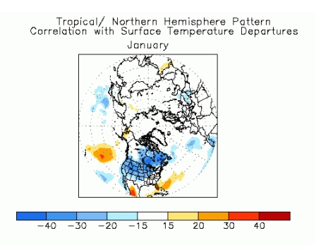
We may have "solved" the mystery. Read instead of just looking at the pictures lol.
From doing the reading at the CPC site, it doesn't seem that the + phase of the TNH is strongly correlated with warm temperatures in the east. Which is surprising given that it seems to pump the SER.
Correlated with cold temperature over much of the rest of the CONUS though.
-
I find BobChill's silence ominous. I fear he may be working an epic melt rant that will make the paint melt off of my walls just from reading it.
-
3
-
-
43 minutes ago, Maestrobjwa said:
That's not necessarily true either...Just look at this decade. We basically went mod nino, nina, nina, neutral, neutral, super nino, nina, nina, weak modoki. And a two-year enso event is not off of the table either! We are due for a mod Nino, imo!
Did we ever actually make it to official El Nino status?
-
1 hour ago, psuhoffman said:
when the NAO again failed
How many -NAO fails does that make this year? Four, five? Man I am going to try very hard to never give two craps about any -NAO being modeled more than a few days away.
-
1
-
-
16 minutes ago, downeastnc said:
He also had a 2 months medical leave early in 2018, he also mentions "personal challenges" which many times means some kind of substance or alcohol issues maybe....either way its his business and he will be missed. Now we have lost Skip Waters and Greg is leaving so there are not many old timers left.
Just plain sigh...
-
Just now, jburns said:
It is a personnel matter to WRAL but a personal matter to Fischel.
Well, the wording of his statement "I take full responsibility for my actions ..." kind of suggests to me that he did something bad to someone else. I could mention the first thing that comes to mind, but it would be baseless speculation. Man, I am bummed I grew up with him.
-
 1
1
-
-
1 hour ago, Moonhowl said:
Just saw that as well; what a bummer.
His parting statement can be found on the WRAL website here:
I am seriously bummed out by this. I wonder what the heck happened.
-
36 minutes ago, Cold Rain said:
Greg Fishel out at WRAL. What a miserable way to end a miserable winter.
First I heard of this. What the heck happened?
-
1 hour ago, JoshM said:
Clown Map


It amuses me that even with biblical snow in Alabama, it still shows a harsh Wake County gradient. Cold Rain would approve.
-
 1
1
-
-
13 minutes ago, luckyamaha said:
EURO MJO
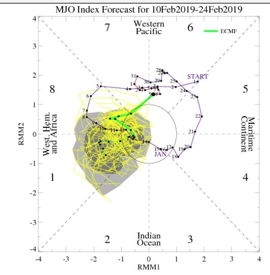
You know, this kind of leaves me nervous. Too much wandering around in the really low amplitudes or even the COD.
-
54 minutes ago, Bob Chill said:
Very hard to capture timing in a single panel with the large spread but this one does a good job showing that d8-10 is far from a locked in west track. Many good tracks in the mix.

I'm kinda feelin this one... One of my rules of thumb with going from a so-so pattern to a decent hit is when a strong west track precedes it. Has to be strong though to reshuffle upper level heights. A weak storm won't do it. This rule of thumb rarely works when trying to go from a crappy shutout pattern to a good storm. Not the case this time. We're in an "almost good enough" pattern but need something to push it to the next level.
Not really pertinent, but e20 is an odd distribution.
-
2 minutes ago, psuhoffman said:
e14 please
then we prepare for March 62 followed by March 58.
If I put my Jb weenie goggles on I can see Feb 1994 this week to Feb 2003 next week, to March 62 week 3 to March 58 week 4. Then I will be done with winter and spring has my permission.
Seems like you would prefer e13.
-
1 hour ago, psuhoffman said:
It does...but before that I LOVE seeing those 3-4 southeast HECS members! Of course we don’t want to see the majority go that way or else it’s the maestro 1980 or 1973 nightmare, but given the type pattern seeing a few 20” NC snowstorms just makes me feel there is both the stj fetch we need and a good chance the boundary stays south of us this time.
PSU, I see what you're trying to do, drag me back in, raise my hopes only to more completely crush them. It won't work this time!

-
1
-
1
-
-
16 minutes ago, BristowWx said:
You’re due. Don’t give up yet.
I haven't given up in the sense if stopping tracking. I just mean to say that I think there is a less than say 10% chance for NC outside if the mountains. I'm going to be here to the bitter end rooting for you guys.
-
15 minutes ago, psuhoffman said:
Ralph seems to think we live in New England. But the gefs also thinks the se ridge isn’t a problem. Snow mean went down some because a lot of members miss us to the south with a hecs lol

Given the trends lately that look doesn’t bother me.
This SE weenie isn't falling for it. My towel is still thrown.
-
2 hours ago, Bob Chill said:
So Don S and DT gave up today. The inverse expectations model has perfomed brilliantly this winter. Time to dust off our shovels and snowblowers cuz it's about to get real here not too far down the road.
Don t know enough to care about DT, but Don S spooks me. Or would if I hadn't thrown the towel in for my area two weeks ago.
-
1 hour ago, BristowWx said:
Gotta move to New England. NE PA would work or NW NJ. Living here is painful if you like snow. We have little margin for error. Other than the snow I like it here in the MA.
Ditto but worse for us in the SE.
-
2 hours ago, psuhoffman said:
That was a rough one for me too. I was recovering from a bad ski accident I suffered in January that year. Had to take a semester off from school for it and so I couldn’t plan a ski trip to cope which is my typical MO. Sucked to end an already sucky year that way.
What happened up your way in March 2001? I remember back then my local meteorologist mentioning that modelling had been suggesting an impressive NAO block, but that it disappeared (imagine that).
-
59 minutes ago, psuhoffman said:
What’s up with that anyways? Even though I am in MD I realize I’m on the edge of this sub and my elevation combined with my latitude gives me a different climo. I try to keep my posts DC/Baltimore centered as much as possible. I like the discussion and analysis and there aren’t enough people here to have the same thing. I do pop into the PA sub sometimes but our sub has more posts in 20 mins than they do all day.
To put it simply you guys have more and better analysis than my home forum. I don't know what it is, but there is a real concentration of snow weenies in DC/Baltimore and environs.
Also, while our climatologies are vastly different, a lot of the large scale pattern drivers which impact you are the same for me. Obviously, I need more suppression.
Also the opportunity to lurk has allowed me to learn a lot.
Hopefully I am not annoying anyone by being here.
-
4
-

The Mystical Month of February--Long Range Discussion
in Mid Atlantic
Posted
If this were a Hollywood blockbuster, this is where it would all come together for victory. The TPV and the SER would push on each other just enough to target five straight 30" + storms at you guys. The SE would be like your loyal sidekick taking the bullet (the SER).