

cbmclean
-
Posts
3,063 -
Joined
-
Last visited
Content Type
Profiles
Blogs
Forums
American Weather
Media Demo
Store
Gallery
Posts posted by cbmclean
-
-
1 hour ago, psuhoffman said:
It was mostly my fault. I’ve seen that pac look destroy winters a few times and I got spooked. I was wrong (hopefully).
The numbers do support the danger of that look but by presenting it the way I did it obviously conveyed more doom than warranted. I did post the good and bad outcomes and said that the bad was only likely if the look persisted past mid month but it was obvious I was nervous and that spooked the resident weenies. I’ll take the blame for that one.
ETA: any suggestions what I should do with my reaper check?
I freely admit to being one of the spook-ees I did not fully comprehend the nature of the duration caveat. I though the pattern was such that when it reached full development, it always stuck around.
Although in my defense, that post did have a pre-post which advertised it as " the least popular post in americanwx history. "
-
 1
1
-
-
2 hours ago, Bob Chill said:
About half of us do iirc. From Dec-Feb I count how much the bay freezes over as a winter grade. There's a pond back in the woods of a nature center near my house that I skate around on when it's safe. Need good cold for that. Ice was over 10" thick in Feb 2014. I personally find cold/dry quite enjoyable until Mar. Once we hit Mar it should either be snowing or 60-70. Anything else sucks
I love cold, any way, any place, any how. Cold with moisture is a bonus.
-
 1
1
-
-
I was out of circulation on the GEFS the last few days, other than what people were posting. Did it fully cave?
-
54 minutes ago, Bob Chill said:
Looks like we won't be getting much sleep beginning in about a week. Anyone who's insane like us and stays up for the euro when things are ripe needs to plan accordingly
I prefer that way to the alternative where I am loosing sleep because I'm emotionally disturbed by the torch.
Realistically, not a good look for the SE for frozen, but I will take dry cold shots over Pacific Doom Blob any day.
-
2 minutes ago, Maestrobjwa said:
What about the opposite? Like 2010 when they couldn't buy a flake up there while we got buried? Lol (was that a rare case where a warm Canada wasn't bad? Haha)
Was it 2010? I remember a year around then when the NAO/AO was so persistently in our favor that it kept funneling warm air up in eastern Canada while I had record cold. Not sure what was happening in NW Canada at that time.
I think that was like the grand finale of good AO/NAO blocking it has been almost universally crappy since then (with a few exceptions).
-
Well we settle in for our long winter's shut-out nap. So as others have noted we are actually in the midst of a pattern change. Unfortunately it's changing between abominable to execrable.
So the general consensus is that while the Pac Puke (PP) is horrible, the Pacific Doom Blob (PDB) is even worse. For the sake of debate I ask: is it really worse?
Certainly they both completely destroy snow chances for the MA (we won't even mention my home area). BUT with the PDB, at least there is a trough in the west and a tendency for decent cold to exist in NW Canada. Whereas the PP as we know completely scours all semblance of cold out of the entire continent. So one might expect that the PDB might be easier to recover from because a shuffle could at least theoretically dislodge the cold our way.
As for persistence I'm not sure which way to grade it. We all know that if you even get a taste of the Pac Puke it knocks you out for a week, minimum, and those AK vortexes can get embedded as ticks. PSU has shown that IF the PDB sets up shop for an extended period of time, it never leaves, but we don't have the data to see how often it might set up for "only" 10 days, vs a whole month.
Any thoughts?
-
Just now, psuhoffman said:
Been out having fun. Ended with 5.2”.
Nice haul for an event that had so many flaws. What is your total for the season?
-
12 minutes ago, Mersky said:
A cold Canada is a good thing. The PV is getting elongated which is clearly visible on the ensembles. The MJO is heading to the colder phases later this month into February when winter usually occurs around these parts. And all your worrying and you got snow today lol
A cold Canada may or may not have any impact here. I mean I like seeing it just because I like the inherent idea of cold anywhere, but there have been winters where the cold stayed completely bottled up in there. I haven't seen any evidence of the MJO going into the cold phases. Both the GEFS and EPS seem to have it headed to the COD, which is certainly better than currently, but not particularly good.
-
8 minutes ago, StantonParkHoya said:
Urban. Heat. Island.
Yikes that is stiff.
-
2 minutes ago, Baltimorewx said:
Temp actually went up 2 degrees at BWI. Was 38 last hour, now 40F. What would be causing that?
If the wind has freshened up, then that will mix the boundary layer at the surface which has been radiatively cooling.
-
Got down to 30.2 this morning, so at least I will have one light freeze on the books.
Also the windshield was frosted over. Can you consider that frozen precipitation?
-
32 minutes ago, CustomWX said:
The 18z GFS based on the Weatherbell maps, is the most classic case of the Wake county gradient.


Wasn't there a guy here who lived in that far south corner. That map must make him physically ill.
-
10 minutes ago, nj2va said:
UHI hell.
I just dipped to 36 here in south Arlington.
How is that physically possible? I am down to 33 in eastern NC. Have the clouds already rolled in for you?
-
39 minutes ago, Ralph Wiggum said:
Depends on the pattern. For example will the one 20" storm stick around or is it coming between torches? The 10 - 2"ers....polar cold all month long with snow on snow? The 2 - 10"ers....back to back within a few days then done? Is it cold enough to stick around for a bit? I'm picky like that.
I will take the 20" snowstorm in between moderate periods. Let that sh!t melt within a week or so. Cruddy stale snow sucks. Plus if inbetween moderation it would be a nice treat.
I also like the idea of 10 - 2" systems tbh if it is going to be BN temps the entire month. 2" of snow every 3 days to freshen things up and only needing a broom? I can live with that.
I'm not sure about the 4 - 5" storms. Sounds tempting but do I really feel like getting off my ass to snowblow once a week? Yes....yes I would lol.
2 - 10" storms. You are the weakest link!
Well for the thought experiment it could go any way you want, but for more fun I would try to collate your choice with a plausible pattern. For example, for the 20" big dog, you could say that it might be one-off event in a highly amplified pattern therefore maybe there is some warm air around so completely plausible that the rest of the month is average or mild. The 10 2-inches would be indicative of a serious cold pattern without a lot of moisture in one individual storm and so on.
-
I would probably go with a nice 10" to get things started plus 5 2-inchers periodically the rest of the month to keep things fresh.
-
So hypothetical question for you guys, since I have nothing else to do down in my neck of the woods.
Say that you have been guaranteed 20" of snow over the course of one month and you could choose how to distribute it? Would you take
-1 big dog wtih 20"
-2 nice 10" slams
-4 respectable 5"'
-10 2" nuggets
or something else. Lengthy discussion of reasonings are welcome.
-
1
-
-
1 hour ago, nj2va said:
Check out this P&C near Johnson Ridge in WA (elevation ~10k feet):
This AfternoonSnow. The snow could be heavy at times. High near 25. Wind chill values between 6 and 11. Windy, with a west southwest wind around 31 mph, with gusts as high as 37 mph. Chance of precipitation is 100%. Total daytime snow accumulation of 35 to 41 inches possible.TonightSnow. The snow could be heavy at times. Low around 23. Wind chill values between 5 and 10. Windy, with a west southwest wind 28 to 33 mph increasing to 35 to 40 mph in the evening. Winds could gust as high as 48 mph. Chance of precipitation is 100%. New snow accumulation of 24 to 30 inches possible.TuesdaySnow. The snow could be heavy at times. Steady temperature around 22. Wind chill values between zero and 6. Windy, with a south southwest wind 41 to 46 mph decreasing to 30 to 35 mph in the afternoon. Winds could gust as high as 55 mph. Chance of precipitation is 100%. New snow accumulation of 17 to 23 inches possible.Tuesday NightSnow. The snow could be heavy at times. Low around 14. Wind chill values between -4 and 3. Windy, with a southwest wind 24 to 31 mph, with gusts as high as 37 mph. Chance of precipitation is 100%. New snow accumulation of 13 to 19 inches possible.WednesdaySnow before 10am, then snow showers likely between 10am and 4pm, then snow likely after 4pm. High near 18. Windy, with a west wind 29 to 34 mph, with gusts as high as 41 mph. Chance of precipitation is 80%. New snow accumulation of 3 to 7 inches possible.Wednesday NightSnow likely, mainly before 10pm. Cloudy, with a low around 11. Breezy. Chance of precipitation is 60%. New snow accumulation of 2 to 4 inches possible.So on the low end they are expecting 91" of snow. Might even make Ji happy.
-
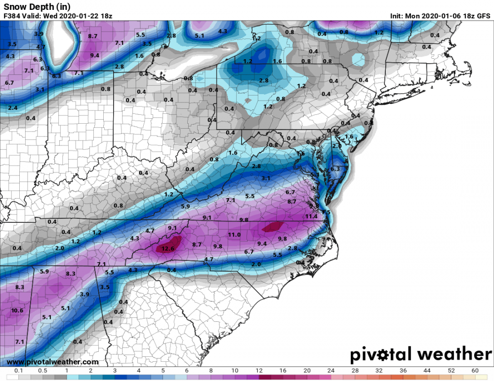
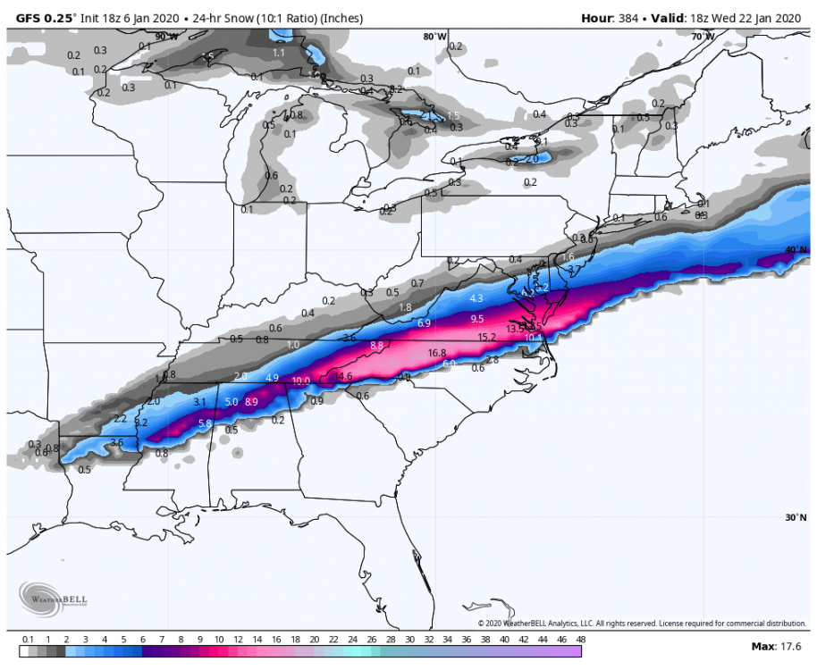
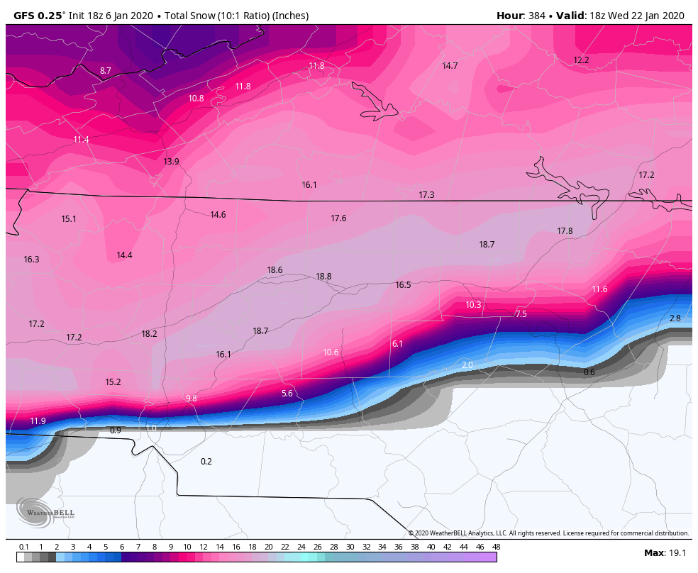
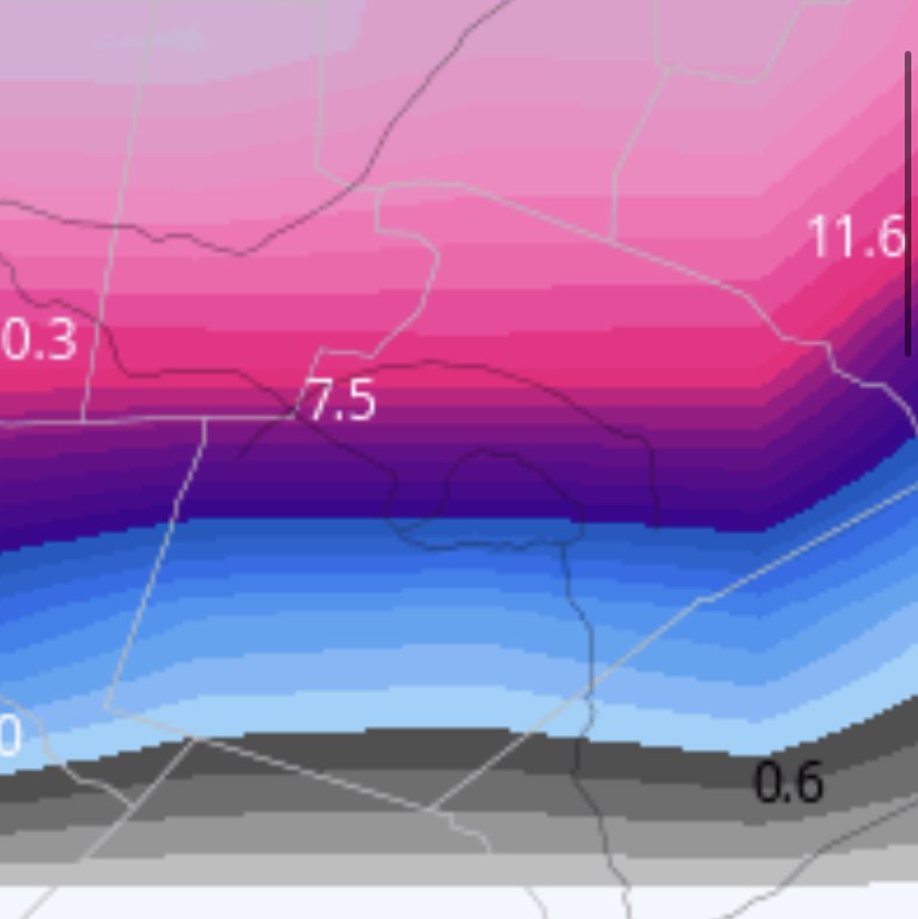
2 hours ago, C.A.P.E. said:


If you compare this pic from C.A.P.E with the same time stamp from Pivotal (posted by SteveRDU in the SE forum), you can really see the effect of the sites' different algorithms for snow accumulation. I live just slightly southwest of the "9.8" in eastern NC. WeatherBell shows me with zilch, Pivotal shows me with 7 inches. Even setting aside the long-lead clown map aspect of both of them without knowing anything else, I can tell you that WeatherBell is much more realistic (or rather less unrealistic). Makes me wonder how Pivotal could have such crappy algorithms or how they could be that different from each other.
-
23 minutes ago, psuhoffman said:
Yes but with the caveat that the pac ridge locked in for more than a short period.
Yes I misunderstood this caveat. I was under the impression that you had found that once the Pacific Doom Blob came to play it, always stayed long term.
-
1
-
-
18 minutes ago, psuhoffman said:
Hate to say it but that look isn’t so good for your area. You would likely need more help.
Yeah, I'm a realist about my climo. Although I love snow, I will happily take mild/wet/cold/dry cycles as opposed to endless SER warmth. I could even hope for nice little- EPO cold snap
-
1 hour ago, Extreme NEGA said:
That was an interesting run at the end:

I was just about to make a funny post saying not to look at the 384 hour GFS if you didn't want to see another I40/85 N special but too late.
One odd thing though C.A.P.E posted a map of the same model run at the same 384 hour time stamp but it was from WeatherBell. It had a much less of the good stuff south of 40/85. Wonder what the difference is.
-
4 hours ago, Cold Rain said:
Yeah, the EPS is looking pretty good out in la la land. Gotta look good out there before it gets in here, I guess. Hopefully, we will see several runs back to back with that look and have it actually progress in closer this time.
Hey CR, can you lower the snow shields and raise the SE Ridge shields for a change?
-
1
-
-
1 hour ago, Bob Chill said:
18z gfs op was a full cave to the EPS/GEPS progression. 18z gefs is a partial cave. Get all 3 global ens looking the same with no can kicking and the spirit of winter can return here. Cracks in the gefs stubborn armor have just shown up...
I am infinitely happier having the EPS on my side and the GEFS on a bad island rather than the usual reverse situation, but I am having a hard time intellectually accepting the hope. I can't see the d10 - 15 EPS, but I haven't heard anyone mention a good NAO look so I am assuming it is so-so at best. PSU's research showed that the ONLY way out of this mess was NAO help, so without that I just can't see us climbing out of this hole. Nothing else was able to turn the trick. If the snow-happy 50's and 60's couldn't figure out a way to escape (other than with the NAO) I can't envision us pulling it off today.
I will happily be wrong.
-
3 minutes ago, cbmclean said:
The thing I find least believable about the whole episode is the apparent foot of snow in December. Next you'll tel me the NAO was negative at that time.

January 2020 Mid/Long Term Discussion
in Mid Atlantic
Posted
We would be excited but we are too busy jumping off the cliff due to the 12z GFS.