

cbmclean
-
Posts
2,590 -
Joined
-
Last visited
Content Type
Profiles
Blogs
Forums
American Weather
Media Demo
Store
Gallery
Posts posted by cbmclean
-
-
1 hour ago, psuhoffman said:
It could...but let’s do this exercise. Let’s say the boundary ends to to my south and I get 3 straight snow/ice events next week. A 6”, 5”, and 3” event back to back. That’s a great week. I wouldn’t complain about that. But then I would still be entering late February 12” short of Climo. Could I pull off another 3/4 events to nickel and dime my way to that last 12” yea...but that’s starting to really become a stretch. If I did pull that off that might be even more epic than doing it with a couple of big storms. That would take almost non stop snow events the rest of winter to pull that off. I would be ecstatic. I’m just saying that seems highly unlikely.
In general, when you refer to "climo" without qualification, are you referring to the mean, or the median?
-
3 minutes ago, Ralph Wiggum said:
Not sure what's been worse the game or that debacle.
I wouldn't say the game has been bad. Just defensive. I like these games once in a while. I don't like the idea of the NFL turning into Arena Football.
-
11 minutes ago, nj2va said:
Boring ass game.
Go Pats
Goff seems lost.
-
4 hours ago, psuhoffman said:
1. An HECS. I love big storms. I don’t care if it’s a one hit wonder if I get a 20” snowstorm it’s at least a B winter.
So 2015-2016 would be a B for you?
-
40 minutes ago, psuhoffman said:
I think my target period is a little after his but either way same result. More snow.
MJO looking more positive for the second half of February as you say. I can't help but to feel a little cheated. The MJO has been taking its sweet time meandering around the warm phases most of Met winter. The only two times it was even briefly good there was some action around. The northern SE got a big hit in early December and the southern half of your area got a nice hit in mid January. I cant help but to have the feeling that this winter really "wanted" op be epic, if it hadn't been crashed.
-
 1
1
-
-
4 hours ago, Waiting on snow said:
Very said times in the winter anymore for the SE. Could be cyclical. All +NAO lately, warm AMO so it could flip. But the longer we go with warmer being the normal I fear I'm wrong and this is the way we're heading.
The NAO is known to be streaky on a decadal scale, so I am hoping that some the warmth of this past decade might be natural variation. That being said I expect regular snowfall (ie a nice one every three years or so) in the non-mountainous areas of NC/SC to cease in the next decade or two.
-
1 hour ago, mackerel_sky said:
I think it’s the ONLY model with an even remote decent look! And that’s sad! All the other ones are straight torch/ SE ridge, ugliness, till Atleast 3rd week of February
Well, if you have to have only one model on your side, I would prefer it to be the euro.
-
5 hours ago, CaryWx said:
GFS also showing no real cold coming back in either. Confidence in getting another decent snow storm in NC growing very low now for remainder of this winter in my view. Getting close to throwing the bloody towel in.
I threw mine in last weekend. There are actually some encouraging signs for the MJO progression for the second half of February, but I suspect that it is too late for us. MA and NE could get score though.
-
1 hour ago, psuhoffman said:
Makes total sense especially the bold. And your point about 10 days ago is true. But I do wish some would not read too much into comments I make specific to one thing.
What I feared has happened. We are losing a chunk of Feb and we did get some snow but a good big storm pattern never developed. But I’m past that now. I’m hopeful it’s only a week we lose. Maybe the first half if the trough axis sets up too far west. We don’t know yet. I’m actually not down on February as a whole. Just because I was upset when the reality the Jan 20-feb 10 period was not going as I thought or hoped doesn’t mean I’m down in the rest of winter. And being down on one gefs run doesn’t mean I’m down on the pattern. Some comments are specific to one thing only and not meant to be expanded to a broader context.
I know very little compared to you so take this for what it's worth. I actually feel that you tend to look on the positive side most of the time. This is not in any way dishonest. Its just that you, like everyone one else on this board is a snow lover, so you want to analyze how a pattern "could" work to get snow. There is nothing wrong with that at all, but I think that many, including me, have looked to your posts as a bulwark against the Debbies. So when you are negative, it is concerning.
What I really care about is accuracy: positive, negative, or indifferent. So I urge to keep posting what you see. If the pattern is relentlessly negative, then your posts should be relentlessly negative (unless you start hating snow somehow lol).
-
2
-
-
1 hour ago, psuhoffman said:
We just can’t see all the variables that go into influencing the atmospheric patterns. We are a long long way from that. We do the best we can but some things are hard to see and other times conflicting signals make it hard to predict outcomes and sometimes chaos just kicks our buts.
Yes, but its that urge to understand more and better which has driven so much of progress in science and technology. I feel the same way he does. I burn to understand the why. I wish I could just wrap my hands around the MJO's metaphorical neck and scream in its face: "tell me y our secrets; why do you do the things you do?!!!!"
-
 1
1
-
-
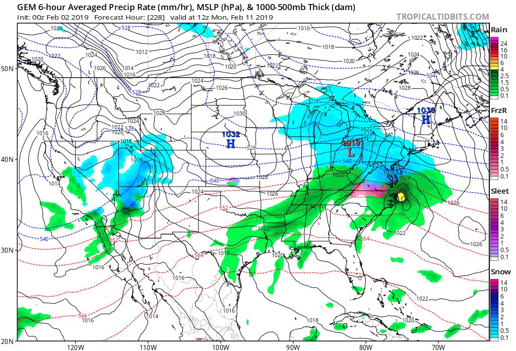
1 minute ago, cbmclean said:
Nice hit at 228 for you guys. Looks like it would be another another DC-south focused event.

And yes I know it is an op at range. I am just learning how to use Tropical Tidbits to follow along with you guys.
-
4 minutes ago, Ji said:
Cmc
Nice hit at 228 for you guys. Looks like it would be another another DC-south focused event.
-
5 minutes ago, Bob Chill said:
The only time the ao was meaningfully negative the whole winter was right before that storm. Same with the nao. Incredible stroke of luck during a season that couldn't have been much worse otherwise.
So I think that I read on here that strong El Ninos tend to dampen the magnitude of the mjo. So I am guessing that it wasn't much of a factor that winter?
-
13 minutes ago, Bob Chill said:
That's not what I said. The majority of our 4" storms or greater are when the AO is negative regardless of the state of the nao. The AO ranks higher than the NAO with correlation to snowfall in the midatlantic. We've had plenty of 6-12"+ storms over the years without a -nao. So I wouldn't say small events only without a -nao.
Check out this article. It's actually pretty relavent to the stuff we've been talking about all year and an excellent explantion of things that all snow weenies should know.
Interesting article. I shudder to think that it was written on the cusp of the "alleged December" of 2015. At you guys got a good storm in January.
-
2 hours ago, C.A.P.E. said:
Now I know how my poor students feel when I am trying to explain simple first order natural(open loop) transfer functions irt closed loop, negative feedback control theory.
Eh just take them straight to state space.
-
1 hour ago, leesburg 04 said:
I'm more interested in the big VD week outbreak. Looks interesting
I'm glad you didn't just say "the big VD outbreak".
-
17 minutes ago, C.A.P.E. said:
CFS continues to agree. Monster block.

As much as I try not to care, it's like a moth to the flame.
-
5
-
2
-
-
1 hour ago, Bob Chill said:
Just looked at the 18z gefs and 12z eps meteos. About a third of the eps and half the gefs show at least some snowfall around and after the 7th. I've seen far worse ensemble output with crappy h5 mean panels. Only takeaway worth mentioning is there's definitely not unanimous agreement with an extended shutout pattern.
How you guys have the stamina to continue analyzing stuff day after day amazes me, especially in a frustrating winter like this one. I don't do anything but read your posts and the emotional roller coaster of the long range models has me exhausted. It must truly be a labor of love.
-
6 minutes ago, Bob Chill said:
Getting close to the -pna being a lock.
I wish it could go "poof" as easily as did the modeled -NAO.
-
Regarding the upcoming warm spell that is being modeled in the LR on the ensembles: I have a perception that when models latch onto torches at d10+ it seems that it verifies much more often than not. On the other had, it seems like modeled cold spells are much more ephemeral. It just seems like all that modeled cold that has been locked in for a while can go "poof" well into the medium range. And when cold spells do occur, it seems like they kind of sneak up on the guidance
Does anyone else share this perception? I suspect (and hope) that it is just selection bias: since I like cold and hate warmth, I notice when warmth is modeled and verified, and when cold is modeled and does not verify. But I am curious if others feel the same way.
-
5 minutes ago, Bob Chill said:
It's a damn sneaky teleconnection. No doubt in my mind the most difficult long lead forecast tele. If it does form this year it will be one of the first times in recent history where it was picked up on 3+ weeks in advance.
The AO is currently negative and will likely stay that way. It's a good start but the AO alone can't offset a destructive neg pna. Thankfully the pna likes to cycle over 2 week periods more often than not and not monthly or longer.
We have a couple possible events over the next week. I'm expecting the future to look a lot less dire by the time we get to next weekend. Hoping to somehow pull off 4.6" of snow to hit 20" by early Feb. I know your yard is lagging but late Feb and early March can easily close the gap. My yard generally doesn't do well after march 10th.
I am just hoping that after taking most of the decade off, the -NAO comes back to being a regular part of our weather soon. As you mentioned before, it is streaky.
-
12 minutes ago, Northern Foothills Snowman said:
Good thing for Patriots they didn’t do like you when they were playing Atlanta in the Super bowl. Give up in the 3rd quarter. Everyone thought Atlanta had won.
The difference, though, is that Patriots actually had an impact on the outcome of that game. There is nothing that I can do to affect the weather one way or another.
-
33 minutes ago, Bob Chill said:
A big AK vortex is a stable feature than can literally cancel an entire winter in the conus coast to coast outside the mountains. Earlier this year was just part of an oscillation that can happen in any winter and is rarely a long duration event. Neither are good but the AK vortex is the worst thing you ever want to see in December. We had legit blocking in 2011-12 and all it did was displace already much above normal airmasses from Canada into the US. Epic disaster is a gross understatement for that type of regime.
I am curious. Is there mirror image regime which is as good as the AK vortex is bad?
-
Just now, Bob Chill said:
2011-12 has an extremely positive epo with a large (stable) vortex spinning around AK for pretty much the entire winter. It relentlessly pumped warm pac maritime air into Canada so our source region was cooked...literally. Very different than this year. This year has been more -pna driven versus epo.
But how is that different from a run-of-the-mill Pac puke?

The Mystical Month of February--Long Range Discussion
in Mid Atlantic
Posted
Sadly, most of the big game animals have been on a very slow boat meandering around the maritime continent and the western pacific.