

cbmclean
-
Posts
3,059 -
Joined
-
Last visited
Content Type
Profiles
Blogs
Forums
American Weather
Media Demo
Store
Gallery
Posts posted by cbmclean
-
-
1 hour ago, psuhoffman said:
Its cold because there is no precip. If there was a storm the return flow ahead of any strong wave would likely mean we warm up given the lack of anything in the flow to offer resistance.
At this point I am ok with that. I know its a different story for you guys maybe getting some March love, but down here it's pretty much over for us. Just give me some cold to keep the bugs at bay for a little while. I just hate hate hate those nights right before FROPA where its like 65 and humid at midnight.
-
3 minutes ago, tcutter said:
Can you define old normal? Do mean in the last 200 years?
If he is referring to the chart that Bobchill posted, it is the 1981-2010 period. This year has just started to sneak into the bottom of the interdecile range.

-
 1
1
-
-
56 minutes ago, StantonParkHoya said:
Wilson is actually in northern NC. Only about 3.5 hours from DC.
Its more east-central. My climatology is nowhere near you guys. I hang out here because the posters are the most knowledgeable and the large scale pattern drivers are mostly the same for me as for you.
NC is fairly diverse for climate at its latitude. The SE quadrant (Wilmington and environs) is darn near tropical. The NW piedmont is much more continental (relatively speaking of course) and the high mountains actually get a good bit of snow.
-
42 minutes ago, MountainGeek said:
He thinks "climo" snowfall for the East coast is a poor representation of ground truth. One big storm can literally be the difference between a great "anomaly" year and a total dud. Lately we tend to be more boom/bust, so we could easily get 3 crap years, then one big year. So maybe an area averages out to 30" a year, but the reality they should be expecting is 10", 5", 20", 15", 70" vs complaining when they don't get 30" every year.
PSU has hammered this point as well - a 15" annual average leads to the unrealistic expectation that we need to get 15" or better to be a "good" year. Median would be a better approach than the mean (which is skewed by the occasional HECS or big winter).
The "ground truth" of what? Does he mean that more frequent good years are holding up the mean while the median is steadily declining? If so, he's probably right. Should be easy to parse the numbers if one has the data.
-
55 minutes ago, mattie g said:
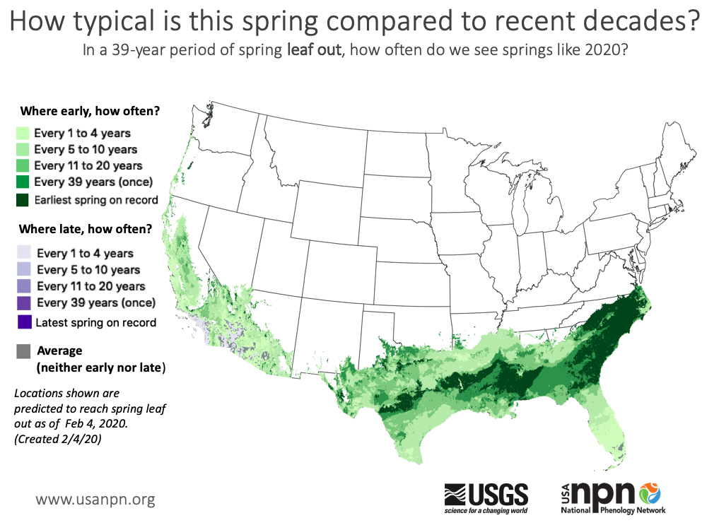
Leaf out already? I know you’re well south into North Carolina, but wow...that’s nuts.
I came back from a work trip last week and saw the maples had started to bud around here. While I recall early buds before, I can’t remember them popping this early.
Sigh
-
 1
1
-
-
1 hour ago, WxUSAF said:
I gave up 3 weeks ago and haven’t looked back. I just want it to stay chilly enough to delay early tree flowering.
My area has recorded its earliest leaf out in the 39 year history of the metric. It is currently 71 °F at my house.

-
2 minutes ago, BristowWx said:
Seems like they come without warning. Epic disasters. Few saw this coming looking at our snowfall contest entries. But nothing screamed epic disaster in November. It just evolved.
I remember PSU saying the seasonal models were predicting a mostly +AO state and him being puzzed why. Whatever they saw, they were right.
-
50 minutes ago, MountainGeek said:
Replying to @ericfisherIt died on November 28th, apparently. Will continue the good old "next window for a storm is" song and dance. See if one or two click a little S&E and see what they give. Interior has done just fine "snowfall anomaly" wise. (which is why I hold utter disdain for the metric)What does he mean that he holds snowfall anomaly "in disdain".
-
17 minutes ago, Plow'n said:
Wait.. so we're not all going to die in 10 yrs from cow emissions?? Count me in
Oh we will, this is just a thought experiment to wile away the time.
-
4 minutes ago, psuhoffman said:
There is a correlation. Plus while that PDB, as you call it, in January can shift and wax and wane the presence of a very anomalous ridge there at some point in January along with a +++AO strongly predicts a continuance of struggles in February also. You don’t get that strong combo without something to do with the background state forcing likely being hostile.
Depressing yet fascinating. I wish I was an eccentric billionaire who could found an institute devoted solely to studying teleconnections seasonal forcing.
As an aside, I also noticed from the graph the strong negative correlation between to anomalies in in the Davis Strait/Baffin Islan/Labrador/SW Greenland area. That is where the PV has been parked much of this winter and I seem to remember showmethesnow mentions this area in a response he posted recently. So apparently when the PV strengthens it tends to get drawn to this area like a moth to flame? Do know why this is? Why isn't it equally like to set up shop over Ellesmere Island or Barrow or Novaya Zemlya?
-
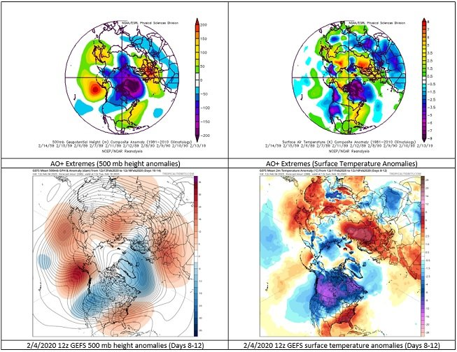
I noticed an interesting graphic on the Arctic Oscillation page for Wikipedia. This is a counterpart to the graphic that Don S. posted for extreme AO events, but generalized for all AO.
So I notice that basically the only midlatitude land which isn't on fire is the western CONUS, just like we have seen this season. But I also notice the mean warm anomaly north of Hawaii. So seems like more evidence that the Pacific Doom Blob of January wasn't just coincidental with the continuing pain that is the AO this year. The PDB is perhaps just a manifestation of the +++++++++++++++AO.
And I am probably not telling anybody anything they didn't already know, but it struck me.
-
4 hours ago, Bob Chill said:
There is a good side to having a +++AO...
Only need 20 more straight years of this, and we might have the Arctic sea ice back in a reasonable shape.
Actually, this is an interesting hypothetical discussion. There is a rather strident guy over at WattsUpWithThat (don't throw tomatoes, I just go there for the graphs, honest) who is convinced that the entire institution of climatology is full of poo and that AGW is not going to be a big issue because it will be severely moderated by negative feedback mechanisms. One of the negative feedback mechanisms that he has touted is increased cloud cover due to convection in the SW Pacific.
So for fun's sake let's just assume the following hypothetical: that he is on to something and the increased MJO forcing in the maritime continent/crap zones that we love so much is actually impacting the AO to become more positive. So let's assume that our recent predilection to go on season-long grand tours of zones 4 -5- 6 is the new base state which will cause us 20 straight years of snowless misery, give or take the occasional fluke. BUT let's also assume that it will cause a continual +++AO which will keep the cold air locked up in the Arctic and will thus help the Arctic sea ice to significantly recover.
So my hypothetical question is: will you guys accept the trade-off. Would 20 years of this kind of fail be worth it to get back to the halcyon days of yore with a cool base state?
-
47 minutes ago, psuhoffman said:
We’ve had variations yes. But all have featured 2 constants. +NAM and ridging centered unfavorably in the PAC leading to a -pna.
I was under the impression that the late December fail was a different beast: the AK vortex Pac Puke. AO was actually negative from roughly Dec 15th - 25th or so, but was trumped by the mild Pacific air.
-
OK everybody how does this year rank among the great dumpster fires of the last several decades? Hating this more/less than 2001-2002, 2011 - 2012 etc?
-
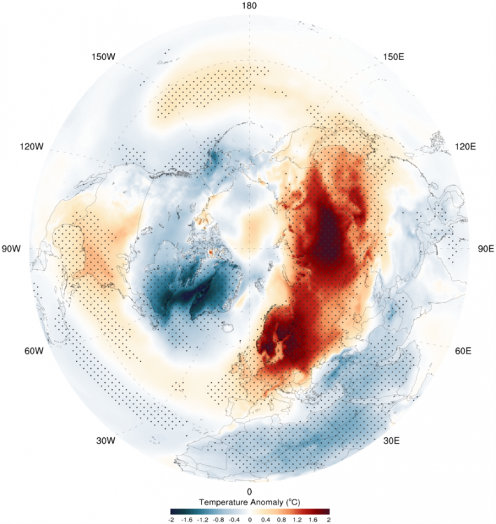
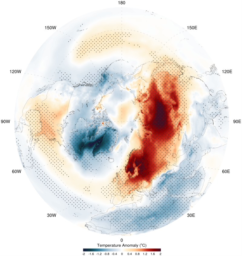
Something is puzzling me about how extreme +AO evens. Earlier today frd shared a post from Don S. about 500 HP/temp anomalies of extreme +AO events. The pic below is taken from Don S.'s post.
So as they teach us in beginner weenie school +AO means PV/polar jet is stronger than normal so tends to keep low heights bottled and cold air bottled up in the high latitudes, with warm air in the middle latitutes. And you can see that to be the case in Don S.' plots, a ring of ridging/warmth in the midlatitudes: the eastern CONUS, Europe, China. BUT there for some reason there is a big trough/cold anomaly in teh western CONUS. Anyone have any idea what that is all about?
-
2 hours ago, DCTeacherman said:
Our long range thread has just become that one guy who posts snowmaps that show no snow over and over.
I'm honestly interested in the AO watch, following the once-in-a-lifetime chance to see it go to +23. I am rooting for the heights in the PV to get so low that the air condenses into liquid.
-
1
-
-
18 minutes ago, Ji said:
the eps wasnt as bad as it was a few days ago but i thought it took a step back
I understand, it's just frustrating.
-
2 minutes ago, Ji said:
i thought the euro and eps were a big letdown today.The Gefs caved to the 00z EPS and then the 12z eps caved to the old Gefs smh
Well that didn't take long.
-
 1
1
-
-
3 hours ago, psuhoffman said:
Gefs “caves” to EPS mid February. Shocking. Good news yes. That look is not a shutout one. But color me skeptical until we get it inside day 10. Yes it’s ok. And it’s a slight adjustment from good. But it’s also only a slight “seasonal” adjustment away from shutout again.
This +1000. We've been teased with better looks (or at least less bad looks) off and on for weeks. Not going to get too excited.
-
2 minutes ago, psuhoffman said:
No one needs to be defensive. Everyone is free to feel however they want. And it’s not like I’m totally thrilled about this. Im just trying to lesson the misery. Serenity now and all that jazz.
Actually, I really admire your ability to care deeply about it, but yet keep it in healthy perspective. You enjoy the thrill of the chase and building your understanding of the science, but you keep it in its proper place.
Although I do imagine you have a nice basement weather-cave with 12 giant monitors showing all the models in a continuous loop, and one wall devoted totally to the Joe Bastardi bathtub theory.
-
1
-
-
6 minutes ago, psuhoffman said:
What if your fear is right. What if we did flip and it’s never going to snow here much anymore? Will getting upset every 6 hours when the gfs doesn’t show snow change anything or make it any better?
No, it won't but that doesn't change how I feel. I have the exact same gnawing existential dread linked to climate change that Maestrobjwa seems to describe. I wish I could consciously chose to not care, but I can't. I am not made that way.
I'm not trying to "convert" you (not that you could be converted anyway). Just expressing my feelings in a safe space with other people who love cold and snow.
-
Vice-regent is right, always right.
-
4 minutes ago, PivotPoint said:
I agree. I don’t care it’s op at range the point is there were a few good runs that gave us a glimmer now it’s a desert waste land of bad runs. And it makes sense given pna, epo, ao, nao, etc. None of which are sided in our favor or progged to be at least in next 10 days
It’s definitely unnatural influence, at least to a degree. The degree being the question. But I will say that 24hr/365 days a year of pumping green house gasses by multiple industrialized nations... it doesn’t take more than 2nd grade logic to understand that this action cannot go on in perpetuity with ZERO consequences. Lol, I mean... come on.
The great debate (if there even is one any longer) ends with a simple truth... there is no “free lunch” that exists in our physical universe. If we want to pump co2 from sun up to sun down across the entire planet , the earth will eventually respond, in kind (of some form). End soap box (sorry)
Oh, you've done it now.
-
Looking at the NAO, at first glance, the 2010s doesn't look too horrible. Definitely skewed positive from about 2013 on.
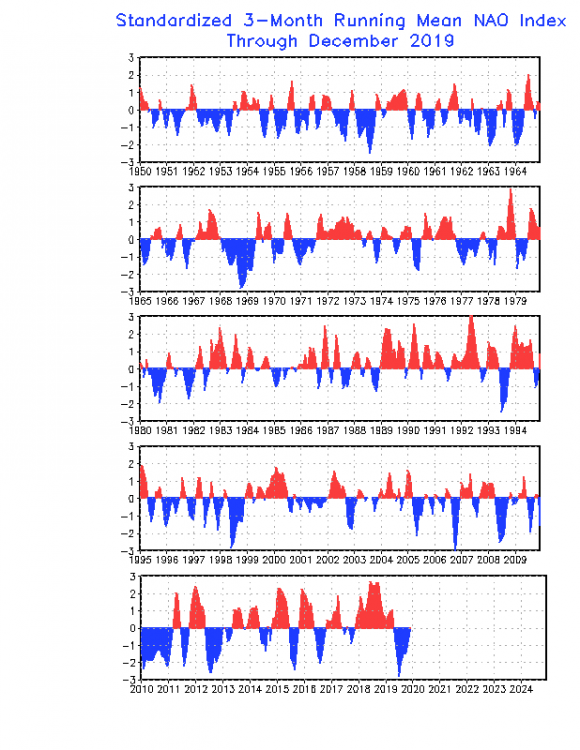
But its deceptive. Most of the blue is in late summer to fall. If you just look at Jan - March, a different and more familiar picture emerges.
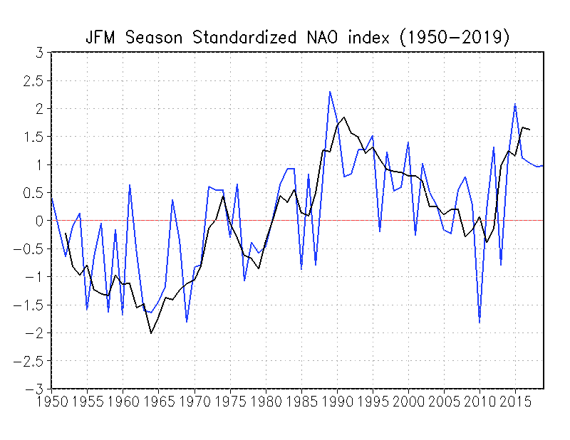
After the spectacular neg spike of 2010 it has been downwhill, or rather uphill, uninterrupted + since 2015.
That graph also clearly shows the state change from the 50s/60s/70s "good ole days" to a much more hostile environment since 1980. Something is clearly different. The big question for us, is it natural variability or you know what?
-
1
-
 1
1
-

February Medium/Long Range Discussion
in Mid Atlantic
Posted
Well that is a known Euro bias, or at least it was in the past. I am still just going under the policy of assuming the actual outcome will be the worst of all modeled outcomes.