

cbmclean
-
Posts
3,065 -
Joined
-
Last visited
Content Type
Profiles
Blogs
Forums
American Weather
Media Demo
Store
Gallery
Posts posted by cbmclean
-
-
3 hours ago, psuhoffman said:
Looking into a lot of what’s being discussed right now...regardless of the outcome this year...a very strong SSW that couples could be good for blocking prospects next winter as well, especially if there are subsequent events
So is there some sort of inter-seasonal memory? I had never heard that.
-
9 minutes ago, leesburg 04 said:
How's Mongolia looking?
They lost contact. The whole country was crushed under the weight of that ginormous high.
-
 5
5
-
-
29 minutes ago, Ji said:
in november Eric Webb looked at the EPS and said pump this pattern into my veins.
NC still hasnt seen a flake outside the western mountains
Actually there were widespread snow flurries in NC on Christmas day as a result of the forcing from that Mega-front. I saw some in Old Fort NC (just east of Asheville) and my parents saw some in Hope Mills (just southwest of Fayetteville). Of course, nothing stuck but it was still nice to see on Christmas.
-
 1
1
-
-
16 minutes ago, Baltimorewx said:
I know we're kinda focused on the ultra long range mid jan into feb but boy does the weather pattern look boring the next couple weeks. Only really 2 storm systems and they're both undoubtedly rain for most of us.
Third straight year of torch for the first 1/3 to 1/2 of January. It's becoming a New Year's tradition.
-
3
-
-
Just now, WinterWxLuvr said:
If you believe in the big three indices then you probably suspect something possible around the 10th.
Which three are those? I assume you include the NAO and AO. What is the third? PNA or EPO? I am assuming PNA because the EPO looked stuck positive for the foreseeable future when last I saw a few days ago.
-
14 minutes ago, BristowWx said:
How so? Most of what I saw was epic blocking and positive temp departure discussion. It might get better after we punt most of January. We are on the threshold of hell. How can it get any worse at 0z?
The blocking could disappear leaving only the positive anomalies.
-
I almost feel that the thread was too positive this afternoon. Time for the 0Z runs to ruin it.
-
4
-
-
Someone posted a twitter link where Ji had posted the first comment. I clicked on his name and went to his twitter feed. That is not what I expected Ji to look like. It did amuse me that his handle is "jhatem".
-
1
-
-
14 minutes ago, losetoa6 said:

-
1
-
-
16 minutes ago, Ji said:
The surface don't care

I like that little tiny cool anomaly over the UP of Michigan. They are going to get their snow regardless.
-
2 hours ago, PivotPoint said:
The only way to help fox our source region this late in the game would be a SSWE
Well luckily, one of these seems to be on tap. It's a crap shoot as to whether it will help or not. But it seems to be coming, nonetheless.
-
13 minutes ago, psuhoffman said:
Sorry...I took a lot of heat for that post (@Mersky)and I totally understand why...but it was 100% accurate. I guess I’m not a stick your head in the sand kinda guy.
No, If we are screwed, I would prefer to know it ahead of time, so I appreciated it. It was still sad, though. Speaking of Mersky, I haven't seen him around lately.
-
16 minutes ago, psuhoffman said:
everyone is mad at that north Pac trough but we’ve had some epic snowfall regimes with that look. 1996, 2003, 2010.
I am not disputing your larger point about the danger of the Pacific Doom Blob (it still haunts my dreams from last year). You have mentioned our unfortunate antecedent conditions. Maybe this look CAN produce, but only if it is not preceded by a month-long continent-wide torch? It would be interesting to go back and look at the preceding month or two before the snow periods of 1993, 1996, and 2010.
-
1
-
-
13 minutes ago, psuhoffman said:
(remember my soul crushing post last December)
My soul still has the wrinkle marks from where it was crushed by that post.
-
37 minutes ago, psuhoffman said:
This post isn’t specific to our snow chances. So hopefully everyone won’t freak out. It can still get cold enough to snow. That temp profile would probably work. Barely. Let’s also assume (because it’s scary not too) that is skewed a bit warm by some outliers. But what’s scary is that is literally the perfect pattern for us to be cold. Look at our source region...straight off the North Pole. The coldest anomalies in the northern Hemisphere are over N America and it’s weak sauce. Mostly -2 to -4 stuff. That’s it. And even that is bottled up on the Canadien prairie without the depth needed to press and spread southeast. @cbmclean pointed out how Asia and Europe have been cold, but their cold source is different. Siberia is a huge land locked high latitude region that is perfect to build deep cold. It’s one thing to see cold there. But even when we get cross polar flow on guidance and the “cold” shifts to our side...it’s not really cold. I’ve been watching this for a while and I’d like to see some evidence we can still build true deep arctic airmasses over North America without that once in a blue moon direct shot from Russia. And even then it seems to moderate quickly once out of the Siberian cold seeding grounds.
Last sustained cold to affect me was late December 2017/early January 2018. That was a legit cold period here, and I think up you guys way as well. Not sure where it's source was. Also, there was a pretty nice outbreak that hit the Midwest in Jan 2019, but never made it here.
-
20 minutes ago, psuhoffman said:
@WxUSAF tonight’s op gfs I think is more indicative of what the ensembles are “seeing” then the bootleg heights issue. From 300-340 there is a full Rex block centered near the southern tip of Baffin with a 50/50 trapped doing loops under it. If anything that should be too much blocking. And yet it rains to Montreal during that period. There is no cold. The flow is blocked. The systems shear out.
However...that is the first major longwave trough after the block retrogrades. Imo, like you said, if the blocking persists I think each subsequent wave will likely have a bit more cold to work with. The euro weekly ensembles, however, never quite get to that critical tipping point where there is enough depth of cold to keep storms from either waiting and cutting or shearing out. I agree that’s unlikely. But the gfs shows that it’s a “real” block...and still warm.
You have mentioned that you don't feel as if super cold cross-polar flow is in the cards this year. What is your feeling about the feasibility of simply getting the Pacific to be mediocre enough to not overpower perfect NAO blocking?
-
Just now, Maestrobjwa said:
Now on those maps you guys post...above normal heights are shown in red?
I don't post many maps. I am actually a novice myself, but I love to learn. Yes on those 500 MB maps the AN anomalies are various shades of red.
-
5 minutes ago, Maestrobjwa said:
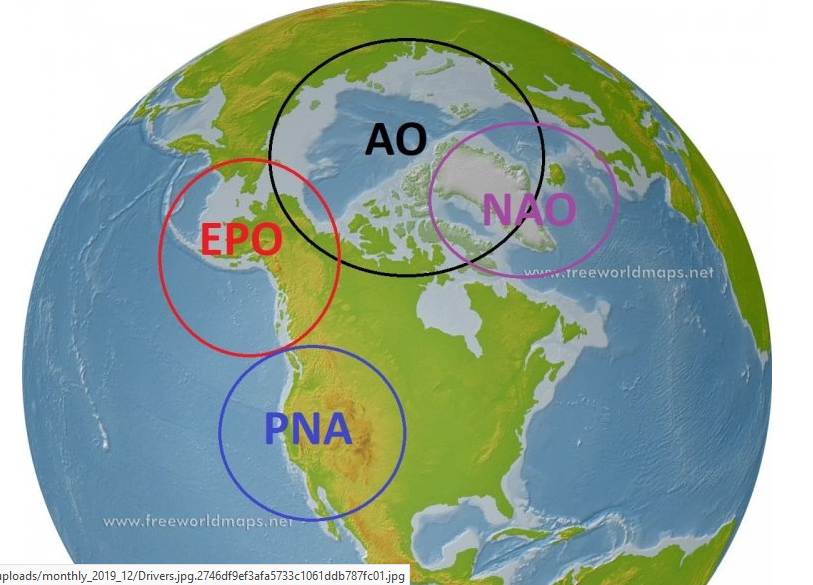
and why an EPO ridge is helpful (though I still need clarity on exactly what it is)
I stole this graphic from the post that PSU made to start off the snow climo thread last year. He has marked the EPO domain. An EPO ridge is just AN 500 MB heights in the EPO region.
-
1
-
-
36 minutes ago, GEOS5ftw said:
Since I don't think it has been answered yet, the 500mb height is a function of the surface pressure and thickness (which is proportional to temperature averaged over the layer). So, BN heights can be the result of BN temperatures from the sfc to 500mb, BN surface pressure, or some combination. When the 500mb height is BN but sfc is AN, that tells me the sfc pressures are low and/or the sfc temp is higher than would be expected for a given thickness. This makes sense since Pacific maritime air masses have steeper lapse rates (warm sfc, cold aloft) than continental/arctic origin air (cold sfc, cold aloft). Think about it - air coming from the Pacific more or less assumes the SST after many days. There isn't enough time when these travel over North America to cool radiatively at the sfc. Also, the latent heat added from orographic precip over the Rockies actually results in a warming of these air masses (chinook effect). Contrast that with Arctic air masses - the cooling is strongest at the surface (surface radiates heat much more effectively than atmosphere), so these tend to have a strong inversion. Further, when you get an EPO ridge the cold air doesn't have to cross the Rockies, it comes down the eastern slope from the north so no latent heat gets added (not that there would be much considering how dry these air masses are).
Models are really good at moving air around - I'm not sure how well they represent the radiative heating/cooling though. It's pretty complex and depends on the surface properties, water vapor, etc. I remember reading a paper about the formation of deep cold air masses, and the authors found that you get "diamond dust" ice crystals - basically very light snow w/o clouds - forming below -40C (or something really cold), and these radiate heat more effectively than the air itself. At really long lead times if these processes are not represented properly it could result in a odd looking temperature for a given flow pattern. There are modeling experts on this forum who know way more than me (I'm from more of a radar/remote sensing background) , so I'm happy to be corrected.
Thank you very much, GEOS5ftw, this is exactly the additional details that I have been looking for. I am intensely interested in learning more about this. If I was looking to invest some hobby money into technician literature about this topic, is there a term for this sub-specialty of meteorology? I don't mean modeling. I mean understanding why air masses obtain the temperature characteristics that they do, and how the get moved to different locations. For example, what made the Feb 1899 airmass so cold in its source region, and how did it get unleashed into the lower 48 with so little attenuation?
-
1
-
 1
1
-
-
2 minutes ago, mattie g said:
Someone snipped and quoted a post of his, if what you’re referring to is what I think it is. Not really a good way to have gone about it - really was taken out of context.
I assumed North Balti Zen was being tongue-in-cheek. It was made abundantly clear that PSU did not consider that outcome to be likely.
-
3 minutes ago, North Balti Zen said:
I go off the board for four hours, come back, and find that PSU has canceled winter...forever. We are Jacksonville now, apparently?
No, Jacksonville does see a few flakes once a decade or so, more like Miami.
-
35 minutes ago, 40westwx said:
I actually feel bad for anyone that actually has to go to work these days..
I actually despise working from home. I am unable to do half of what I need to, and the half I can technically do online is much less efficient because of network issues and difficulties in communicating with coworkers. I go in as often as possible.
-
 1
1
-
-
3 minutes ago, WinterWxLuvr said:
That relationship is only a general guideline and if I’m not mistaken acts slightly differently in winter and summer.
That's actually the part of meteorology that really interests me. I find cyclogensis, precipitation, winds speeds, only mildly interesting, but I am fascinated by temperature. Unfortunately there just isn't a whole lot of easily available information out there beyond the simplistic guidelines we have just been discussing. I need to find a text book on "Atmospheric temperature patterns and 500 MB analysis".
-
1
-
-
3 minutes ago, Ralph Wiggum said:
If you are referring to geopotential heights, then do a loop of them on the conus from 18z. The 540 line spends most of the 384 hrs north of the Canadian border. So I dont think you are seeing a negative correlation between those heights lines and 2m temps. The PV (lowest heights) is on the other side of the hemisphere for the most part. I just picked this map to illustrate my point:
We are going to need pac help to get the lower heights and PV into Canada and the US....period. BUT marginal temps can still work during prime climo so keep that in mind.
That makes perfect sense, but the plots posted by PSU showed the Euro depicting a negative average 500 MB anomaly in the eastern conus while simultaneously having a positive 2m temp anomaly. I am specifically referring just to those two plots. Anyway I realize its probably related to factors well beyond my knowledge at this time. And I am hoping it doesn't come true.

January Medium/Long Range Disco Thread
in Mid Atlantic
Posted
Bootleg.