

cbmclean
-
Posts
2,590 -
Joined
-
Last visited
Content Type
Profiles
Blogs
Forums
American Weather
Media Demo
Store
Gallery
Posts posted by cbmclean
-
-
6 minutes ago, Maestrobjwa said:
Yeah probably not the best idea...real sensitive issue (and one that can sink a thread in a heartbeat, lol)
There is actually a whole forum devoted to it on here. I hardly ever go over there though. I imagine the flame wars must be epic.
-
 1
1
-
-
1 minute ago, psuhoffman said:
That vortex sitting in Canada is promoting low pressures to our north and enhancing the westerlies under it and causing the mass exodus of cold before the storm. Could change. But that's why I'd rager no PV at all over a badly placed one.
"rager no" = "rather have no"?
-
Just now, Cold Rain said:
SE Wake. Horrible place to live.
Well I come from Fayetteville so we get even less snow there, but I know it must be painful to be near that Wake County gradient. Looking at snow maps at times it seems that if you looked up the street you can see more snow.
-
1
-
-
20 minutes ago, SnowGolfBro said:
We discuss all the different indexes and patterns and models and so on on this forum. Weather is complex and snow in the MA is complex (never easy) And you make the blanket statement that “the global climate is becoming less and less conducive to winter cold”. Curious if you have any evidence of that or if it’s just an opinion
Well, I did not mean to to start an AGW debate in this forum, I was just discussing my personal pessimism. I probably shouldn't have mentioned it at all.
-
1 minute ago, psuhoffman said:
In fairness I never bought into the early January potential. The system on the 3/4 has some potential as an island in a sea of crap type of way but overall I thought it was too soon and the mjo progression argued against a real flip to favorable until later.
The changes towards the end of the gefs and EPS have me slightly concerned. I know analogs aren't perfect. 1995 happened and we don't really know why when all the other best analogs were so different. Maybe this is another anomaly. I'm aware of that potential. But if I expected it to be warm now the fact it is doesn't bother me. I won't panic until I see tangible evidence the expected pattern flip mid month is in trouble.
As for the "optimism" and "why do we fall for projected pattern flip lessons" I could flip that. Why don't the pessimists ever learn from years like 1987, 1993, 1999, 2000, 2005, 2007, 2015, 2016?
Flips do happen. I remember all those years. How bad they were until mid January. They all flipped cold and at least somewhat snowy after. Some epically so. And several of them were ninos. And analogs I'm too young to remember like 66, 69, and 78 argue in favor of it also. I remember those examples because I'm an optimist. Others latch onto the fail years and ignore those because they are pessimists.
I am not part of the mass rush to the cliff yet. But just in the spirit of general discussion I will say that I am generally pessimistic by nature. That being said I actually believe that my snow pessimism is generally justified. I am a person who loves snow and cold, who lives in a region where the climate does not favor snow and cold (SE is even worse than MA!), living in a time where the global climate is become less and less conducive to winter cold. I live with the honest fear that every snow storm will be my last.
-
1
-
-
3 minutes ago, Bob Chill said:
lol. It was a joke post. BOMM is the australian model. The green line is the mean and the yellow lines are all the ensemble members. The #s are a numerical measurement of the strength of the wave. Anything over 2 is a pretty strong wave.
Yeah I realized you were being sarcastic (about the clarity), but it seems there is very little easily available info on how to read that octant chart so I appreciate the info.
-
Just now, Bob Chill said:
nah, crystal clear on this panel. We're good, bad, and everything else.
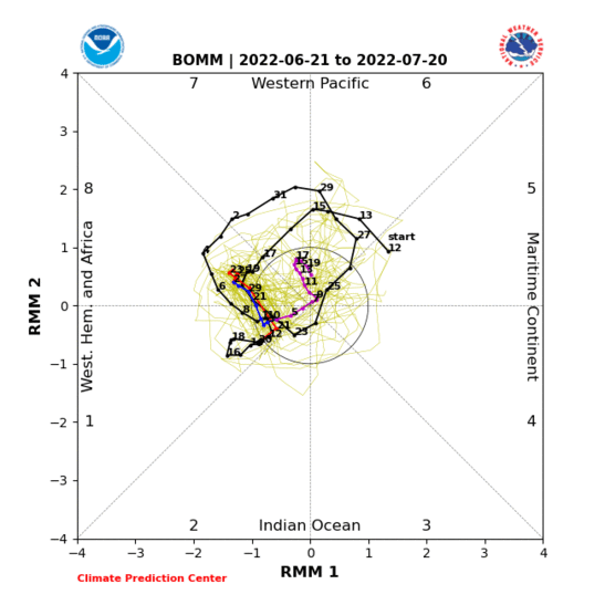
Bob, could you educate me a bit on this chart? I understand the octants, but what are the x and y axes RMM1/RMM2? What is the green line "BOMM"? And what are all the yellow lines?
-
16 minutes ago, Cold Rain said:
Even in the crappiest winters I got at least a bit of sleet, zr, and a few flakes of snow, which is all I got this winter so far. Literally 1-2 miles down the road from me got 3” with the December storm. I expect winter to get better. But so far it has sucked rolyally so far for me.
Where exactly are you in Raleigh? I am guessing somewhere in the south.
-
10 minutes ago, Cold Rain said:
Must be nice. So far, this ties the worst winter ever for me.
How so?
-
43 minutes ago, SnowGolfBro said:
Yea if i get 30 inches but somebody in NC gets 40 inches I’m out lol
You guys do know that there are areas in the NC high country that average 50+" right? Mt Mitchell is just over 90". Not as good as far western Maryland, but still respectable.
Of course we over in the low-lands are lucky if we see 5" in a year.
-
6 hours ago, mackerel_sky said:
Yeah, it’ll be clear by January 1st, this winter will suck like the last 5 or so. Unicorn SSW and perfect looking long range patterns, are going by the wayside. Somebody start the 2019 hurricane thread! Put this craptastic to bed
I think that's at least at least the third time you've used the phrase "unicorn SSW". This puzzles me because we had a SSW which impacted the sensible weather earlier this year, in March 2018. Unfortunately, it was too late to help us in February when it really could have made some difference, but March featured notable NAO blocking which lead to a cool stormy month.
It looks like the fact of the SSW is high probability. The real question is whether or not it will be "downward propagating". There is significant discussion about that point in the MA forum. There is a poster named Isotherm, whom other appear to respect, who believes that it will. Others are less confident.
-
27 minutes ago, psuhoffman said:
Many of us have been following your updates. Excellent read as always. Thanks!
PSU, I am curious as to your view of Isotherm's opinion that the atmospheric base state promoted a cold december abset the PV disturbance. Earlier today I think you mentioned that later December warmth was highly common in El Ninos.
-
1 hour ago, LP08 said:
For some good news..12z EPS looks much better than 0z through 222. PV in NE Canada, -NAO, +PNA, -EPO with the Aleutian Trough. I'd imagine the there will be some good looks in the individuals with that look.
240 below.

Would anyone be willing to explain how to visually evaluate the PNA and EPO state from an H5 map like the above?
-
 1
1
-
-
10 minutes ago, psuhoffman said:
All of it...the GEFS/EPS/GEPS all look about the same from a longwave pattern POV. Details are different obviously but not the kind of thing you would see at range and be picky about.
The EPS timing doesn't match because the publicly available maps only go to day 10 but if you could see the 5 day mean for 2 days later it would look very close to the GEFS and GEPS. The general pattern is the same for January 1-7th across guidance.


I see that the EPS has a much stronger South Atlantic ridge. That makes me nervous. To see it creeping into eastern NC, where I live.
-
3 minutes ago, psuhoffman said:
THe first week of January actually looks pretty good at H5 even now, but we are not seeing a specific threat materialize and so it doesn't matter. The storm looks suppressed and so we are ignoring the fact that we look to have a favorable pna/nao pattern. Not every good look ends up with a snowstorm. Or maybe the guidance is missing something and we do get snow. But either way the good look that was on the long range guidance did come to fruition it looks like. Then week 2 of January now looks like a bit of a relax, not awful but not as good as it looked from longer range. Then the guidance says it gets better again after that and we will have to see how that goes but so far the long range guidance for January doesn't look like it has been that off. YET
Which guidance do you mean? GFS or EURO (or other). Ops or ensemble?
-
1 hour ago, psuhoffman said:
I am about a mile south of PA and at about 1050 ft in elevation at about the highest point along Parrs Ridge. That makes my climo closer to Norwich CT or Providence RI than most of the mid atlantic.
My average snowfall is about 40". My median (better indicator of normal) is 33.5". In the last 30 years 15 here were between 20 and 40" so that is what I consider typical. 8 years were above 40" which is a truly great year imo. 7 years were below 20 which is what I consider a total crap year.
In effect my snowfall climo is about double most of the urban corridor. BUT... even up here a pure all snow warning event is pretty rare. Typically there is only one of those per year even up here in a normal year. Only in those rare great years do I get a ton of those type storms up here. A lot of my snow comes from nickel and dime 1-3" clippers and light events, or from the front or back end of storms that feature some mix or rain. Only rarely do we get a flush hit of 5" plus of all snow even up here. That is why I LOL at people who have half my median snowfall acting like that type of event is all they will accept and it needs to happen regularly for them to be happy. They wouldn't even be happen up here most of the time with their expectations.
So there is a big difference between you and say, Bob Chill in Rockville, in terms of median snowfall?
-
1 hour ago, WidreMann said:
Depends on what parameter. I wouldn't trust them on exactly how much rain/snow will fall or the exact temperature, but they've actually improved enough over the past decades that they're not usually too far off even in the 6-10 day range. Remember how the models had the December 9th storm more than a week out?
Yes they did have that storm pegged early, but from reading others post it seemed like that was unexpectedly good performance.
-
15 minutes ago, NC_hailstorm said:
All the models are scoring very poorly the last 5 days,anything 5 days and beyond should not be trusted at all until things shake out.
I was under the impression that you shouldn't really trust the operational models past 5 days in general.
-
2 hours ago, psuhoffman said:
It snows almost every year. typucally between 7-18" across the corridor in 60% of years. The other 40% are split between 20% that are better then that and 20% that are worse.
Imo the problem seems to be many act like we are New England and it should snow all the time. Then they disqualify most of the snow we do get because "it came too early or too late" or "it didn't stick to roads" or "it changed to rain" and then continue to complain that it never snows even if it just snowed a few weeks ago! Seriously when your median snowfall for the whole season is about 12-16" for most around the area how do they get to be so picky? Im not even close to that picky about how we get snow. Even if they lived here with my climo they would be disappointed most years. Even up here a pure all snow warning event is a relatively rare thing. I will never understand setting the bar so high that you will be miserable 80-90% of the time!
So Mr PSU, just curious what is the climate like in your neck of the woods. Your profile says you live in Manchester, I was wondering how the local climate affects your snow.
-
For a certified Pacific puke pattern, the last few days havent been bad at all. I have been in Old Fort, NC in the foothills. Highs have been upper 40s lows upper 20s to lower 30s. So below normal actually.
-
38 minutes ago, SENC said:
High 54F & Low 41
Clear Skies..
pressure 30.26
Dew of 36F Humidity of 74%
Winds Variable SSE--- -> 0---MPH
Think I'll go for Speckled Sea Trout & Virginia mullet fishing in the Morning

-
A few weeks ago there was discussion on here of the euro overdoing lows in the Southwest. Fast forward to Christmas. My wife got me Tim Vasquez's Weather Map Handbook. One the first thing I noticed when flipping through it was this starement:
"The ECMWF is notorious for overdoing or overpopulating cutoff lows, particularly in the Southwest US."
You guys know your stuff.
-
3 minutes ago, Bob Chill said:
The easy short answer is a strong synoptic miller a, b, or hybrid that affects a large portion of the east coast. A KU can be all rain here or even a whiff like Dec 2010.
Thanks!
-
2 hours ago, Bob Chill said:
Looks good in the temp department but also looks like it would be on the dry side with dominant northern stream. Much better than a shutout pattern of course but not the kind of longwave pattern that would keep the juicy southern stream action going.
I'm not very picky so anything other than a shutout is fine. It's not a KU look so Ji won't be thrilled with it.
I know that KU stands for those two guys who literally wrote the book on big snow in the east, but what is a "KU storm"? Is it a specific type like a Miller A/B or does it just mean a big storm?


December/January Medium/Long Range Discussion
in Mid Atlantic
Posted
We abscond?