

cbmclean
-
Posts
2,590 -
Joined
-
Last visited
Content Type
Profiles
Blogs
Forums
American Weather
Media Demo
Store
Gallery
Posts posted by cbmclean
-
-
1 hour ago, NC_hailstorm said:
Hit on the Euro today day 9/10
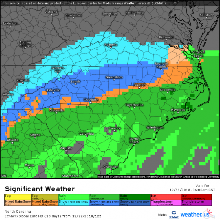
Wow an I85 transition line. Who'd have thunk it?
-
3 hours ago, mackerel_sky said:
Just seems like the new norm to be a week or so away from Christmas and searching 10, 15,20 , days ahead to look for the big chill and pattern change!? It’s almost like clockwork! We have the magical unicorn ready to pull out of our butts ( SSW) to make the cold and snowy pattern set up, but that’s far from a certainty! I look forward to the snowman pics from Iran and Egypt in the upcoming weeks, as the split goes the wrong way for us!

Well the 2010s have definitely been noted for some impressive winter torches, but to be fair the historic cold last year set in right after Christmas.
-
 1
1
-
-
8 minutes ago, psuhoffman said:
No one thinks it's going to happen. Just having fun. Nothing in "real" range to discuss.
I treat digital snow as a proxy for the health of the overall pattern. If the model's aren't spitting out fantasy-land storms, then it is a sign that the long-range pattern is looking sucky. Conversely, healthy digital snow totals means that that the players are on the field to some degree.
So I think it is completely rational to be happy to see this as a sign of a less hostile pattern in January.
-
1
-
-
End run GEFS doesn't look quite as horrible. Still nothing to get excited about. Still has that pesky Alaska low.

-
4 minutes ago, psuhoffman said:
That is literally the complete opposite of what we want. Flip the colors and we would be excited. lol
Nothing is ever easy, is it?
-
8 minutes ago, psuhoffman said:
We didn't cash in during a good longwave pattern early then everything went to crap the rest of the winter.
Hmmm. This statement certainly won't cause concern in the MA forum.
-
1
-
-
1 hour ago, SnowGoose69 said:
11-12 I think was a neutral or weak Niña. It was similar to 01-02 in that nobody really knew why it ended up sucking as bad as it did. By that I dont mean nobody knew what features caused it to be bad they just had no idea why the features setup the way they did given the setup argued for something different both years headed into those winters.
IIRC, 2011-12 was a wall-to-wall hostile PAC with pacific fire hose. What was the story with 2001-2? I was in college then and I remember it being mild, but I wasn't into the weather as much then so I don't know what the hostile feature was.
-
4 minutes ago, jaydreb said:
18z GFS has yet another massive storm coming up from the south next week. No cold air anywhere.

It's not true that there isn't any cold anywhere. You can clearly the 540 line in the gulf south of New Orleans.

-
1
-
 1
1
-
-
11 minutes ago, WarmNose said:
Models have been trying to kill that western ridge for over a month. It never disappears for more than a couple days. We may hit some transient mild periods but I see no major torch in the near future
I wasn't implying that I was hugging the d16 GFS operational map. Just that we really want the EPO- dump to head this way and not out west.
-
Since we have been focused on the storm over here I have been hanging out in the MA forum for mid/long range discussion. According to Bob Chill and PSUHoffman At least most of the next two weeks should be mild across NA due to zonal flow due to the dreaded Alaska trough. After that the trough should retrograde and there we will come to a fork in the rode: An EPO trough will develop somewhere in the CONUS. If it goes east then cold in combo with the typical nino STJ could make life good.
If it goes out west though...
-
My forum is still preoccupied with the snow, so I come here for actual mid-long range discussion. Hoping to continue to be able to see the end of the approaching mild period on the ensembles, and hoping to see that end move forward in time instead of staying stuck at day 16.
-
55 minutes ago, psuhoffman said:
We are not going to have another debate about whether we should talk about long range guidance in the LONG RANGE thread. We all know any one run of any guidance at day 15 is low skill. But no one here is basing anything seriously on one run of anything. What do you think we should use to discuss long range pattern trends? Chicken bones and tarot cards?
I watch the sloshing in Joe Bastardi's bathtub.
-
1
-
-
36 minutes ago, psuhoffman said:

Off topic, but northern Greenland sure does look chilly. There normals are already cold this time of year.
-
Temp barely budging: 39/34.
-
1 minute ago, mjwise said:
Not much forecasting left to do, and the only short range model to watch (HRRR) has been ticking warmer.
Uh oh, did it cave to the NAM?
-
Awfully quiet in here now.
-
2
-
-
Solid boring 40 F/34F here in Wilson.
-
6 minutes ago, FallsLake said:
HRRR looks good for our area. 2z is out to be 12 and there's plus 6" totals through the Triangle. And it's still snowing.
I would love the HRRR to be right, but is there any reason to trust it over the NAM? I have heard it mentioned over and over that the NAM is killer with dealing with the warm nose.
-
1
-
-
1 hour ago, lilj4425 said:
The snow line in Spartanburg moved back north. That’s it. I’m moving to Calgary.

Actually Calgary is prone to snow-eating Chinook winds. Might want to try the Michgan UP.
-
 1
1
-
-
22 minutes ago, CaryWx said:
That works for me skywarn. Is everybody ditching the ride because of the latest NAM. Sorry, been away
Well, there are clearly two camps. HRRR says plenty of love for RDU. NAM says that at least 1/2 of the QPF at RDU will be the tears of snow weanies. The NAM is supposed to be good with the warm nose so I have a bad feeling about it.
-
1 minute ago, Tigerchick224 said:
That makes perfect sense! Thanks.
.My pleasure.
Of course I meant "battle between cold, dry air and warm, wet air".
-
1
-
-
2 hours ago, Tigerchick224 said:
Has there ever been a storm in Upstate SC where the warm nose was a non-factor? I’ve lived here my whole life but have only really gotten into the technical aspects of meteorology the past few years and it seems it always has to rear it’s stupid, ugly, head every time!
.Actually thermal issues are a hallmark of many large snow events wherever even up to New England. The fundamental fact is that cold air tends to be dry and wet air tends to be warm. So big snows tend to happen on the front lines of a battle between cold dry air and warm dry air, which means the thermals will generally tend to be unstable.
-
3
-
-
27 minutes ago, UpstateSCBud said:
That's a good question. Climatology is a real b*tch and it's hard to get just snow here. Even in the 93 superstorm I remember sleet mixing in here.
Well, to be fair, the 93 superstorm was in March.
-
1
-
-
1 minute ago, wxdawg10 said:
i think he meant January 2017. the infamous bust
Yes, I meant Jan 2017. Sorry.


December/January Medium/Long Range Discussion
in Mid Atlantic
Posted
Well, the thing is, for both the MA and even more so the SE, there is no guarantee that the main course ever gets here, so it is always stressful. I don't chose to feel that way, but there is nothing I can do to control it.