

cbmclean
-
Posts
3,062 -
Joined
-
Last visited
Content Type
Profiles
Blogs
Forums
American Weather
Media Demo
Store
Gallery
Posts posted by cbmclean
-
-
An interesting post from one of the best MA forum posters. Sigh.
28 minutes ago, psuhoffman said:I agree completely with the first part. But I’m not sure I agree with the second. Since March of 2018 we haven’t had any real -NAO blocking. We had some bootleg transient ridges as a tpv lobe traversed a location to promote a short lived ridge there. But what’s coming up seems like a classic west based -NAO episode. It also seems likely it gets muted for a while by as hostile a pac as we could have.
The -NAO actually begins in only 24 hours as the current wave breaking near 50/50 builds a ridge over the top that links with the current epo side block. By 48 hours it’s a classic west based -NAO with 50/50 low representation.

2 days later even a stronger west based -NAO representation. And it is “blocking the flow” despite a raging fast pac jet and gulf of Alaska vortex the next wave is being blocked under and is about to become the next 50/50 low. That’s a classic evolution. Lower heights exist in the means there because in a -NAO every wave gets forced under through that domain. But one system doesn’t just sit there for weeks on end. If it did we would just be frigid cold and bone dry.

A day later (now 4 days unto the -NAO) and we still have a classic ridge over low representation but the pacific problem is rearing its head. That isn’t just a bad pac, it’s atrocious! That gulf of Alaska vortex is pumping a ridge into central NAM. The blocking isn’t breaking down but the central N Am ridge is going to merge and get absorbed which severely muted its effect.

But even with that, it still manages to force the next wave under us! With that pacific look that storm should cut to Hudson Bay! If you want to know what our weather would look like without a -NAO with that pac just go back to December 2015. The pattern over the east is blocked, that’s how a system gets suppressed south of us despite a vortex on the west coast. It’s just not going to be able to completely offset a record pac jet in an awful alignment.

At this point we’re 11 days unto the -NAO and the pac jet has cut underneath as soon as the vortex off the west coast relaxed some as is typical in a -NAO. The pac is still bad just not the absolute dumpster fire it was. This is still a classic west based -NAO with lower heights through the 50/50 space through the 11 days. Who knows if it’s even right this far out but the representation is classic blocking regime imo.

Now at day 15 it’s evolved into an east based block. Ironically the NAO index will be more negative now since its calculated at Iceland. But again who knows if it’s right and the monster Scand ridge would imply we likely cycle back into blocking not break down.

The look past day 5 could be BS. But what we see on guidance is classic -NAO imo. It’s muted by other hostile factors. We went through a similar problem towards the start of the last great blocking period in Feb into Mar 2018. We suffered a perfect track rainstorm then a couple near misses due to an imperfect trough axis because of a less ideal Pac. Then a storm got suppressed. It was during the second cycle or pulse of the NAO that we finally got a nice snowstorm in late March. No idea how this will play out. But I do think this is finally a real -NAO. But that doesn’t mean we get snow. We had a real -NAO most of the winter of 2000/2001 without much to show because of a not ideal pac. December 2001 had a great NAO block the pac ruined. It’s hapoened before.
-
8 minutes ago, psuhoffman said:
I respectfully disagree (and just posted a thorough explanation in the main thread) with the claim that it’s not real blocking. But I agree 100% that it won’t likely matter wrt snow chances with the pacific looking the way it does. The NAO could offset a mediocre pac but not what’s coming. But the upside is blocking regimes can after recycle and persist and if the pac relaxes we would be in business. The blocking regime coming will save us from a dec AO number that would have been a bad omen for the rest of winter. We will likely end up with a near neutral AO and NAO number now. That’s a lot less hostile for our chances in Jan/Feb. There is very little correlation with March either way.
Thanks PSU. Your knowledge is appreciated as always.
Do you mind if I share this with the SE forum?
-
32 minutes ago, psuhoffman said:
The Australian hasn’t been updated since February
Ah I did not notice that. Maybe it had to shut down when some of the members started breaking outside the freaking box.
-
1 hour ago, C.A.P.E. said:
Advertised LR pattern may be wrong. MJO forecast may be wrong. Do all the global ensembles agree?
I know you know this, but the MJO is not the sole driver of the long wave pattern either.
Well, it seems both the GEFS and the EPS are agreeing it is time to head for the bunker. Haven't checked the GEPS lately.
As far as MJO, the EPS has it floating around in the COD. GEPS seems to be predicting an emergence into phase 5 or 6.
Euro seasonals has A LOT of spread but mean is 5/6.
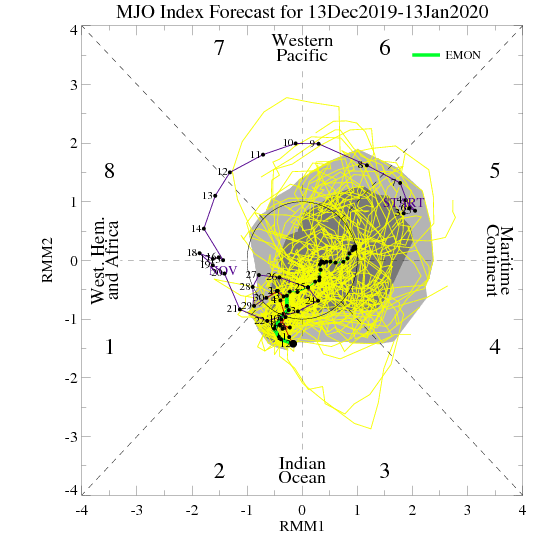
Then there is the Austrailian model. It clearly shows direction.
-
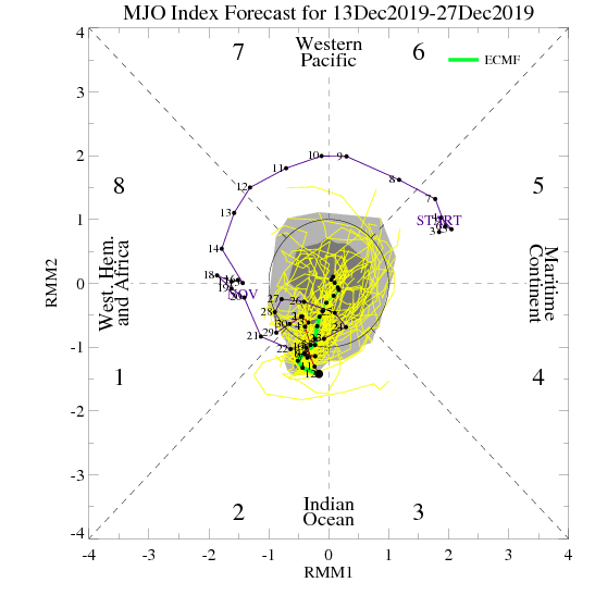
GEFS MJO forecast. Kind of surprises me that the Pacific would be so hostile with this MJO forecast.
-
49 minutes ago, psuhoffman said:
It will be funny if after years of not being able to buy any blocking the first legit NAO block we get suppresses a storm to Florada.
So is it blocking or not blocking? I don't know enough to tell the difference myself but some discussion in the main thread is claiming that it is not blocking at all but rather super progressive.
-
Got 2.46 for the event.
-
3 hours ago, NC_hailstorm said:
Temps through 12/13.Couple really warm days (12/1 and 12/10) keeping temps closer to average.
GSP -0.6
HKY 0.0
AVL +1.1
RDU -0.2
GSO -1.2
CAE +1.3
CLT +1.2
Unfortunately should be well above normal after the looking Pac puke. Still not too bad for December in this new era.
-
24 minutes ago, psuhoffman said:
How far are you from Snowshoe?
Nearly six hours unfortunately. NC has a couple of rinky-dink ski areas which aren't much closer. Went to one once but predictably it was in the middle of a warm period so it was kind of pathetic. Still had fun though.
I have tried to interest the wife in a compromise with snowshoeing, but she still has no interest. She hates cold.
-
Just now, Mr. Kevin said:
Both models are more erratic now than in the past.
I have heard that said repeatedly, but I have to admit that I am skeptical. From my understanding, it is clear that model verification scores have significantly improved over the last two decades, so I have a hard time envisioning why they would become more volatile. Perhaps the weather itself has become more volatile and therefore more difficult to simulate? But again, that should show up in decreased verification scores.
-
2 minutes ago, psuhoffman said:
You’re making me want to plan my annual ski trip. With the deluge out there I’m thinking early January maybe this year. Torn between hitting up Snowmass/aspen or Solitide/Snowbasin in Utah. I’ve yet to adequately explore those areas. I love off piste and tree skiing. I know snowmass has some excellent stuff off the cirque and burnt mnt glades. Salt lake is much easier access for a long weekend trip. I might just wait until a week before and let the snow conditions decide for me.
I've wanted to get onto skiing for a while. Living in eastern NC with parents who have no interest didn't start me off well. My wife has no interest in it, so not much hope of it anytime soon.
-
Man I have enjoyed the seasonal-to-cool aspect of the first half-of December, but man I wish that the Pac puke had chosen that time to go apesh!t instead of right at Christmas.
-
9 minutes ago, psuhoffman said:
Almost a total cave to the euro on the Dec 22 storm. Gfs went from the idea of sliding the upper low across the south to cutting it through Minnesota in one run. It still holds onto some stj wave but mostly it was a cave to the euro.
Eh, only took it until D8/9 to cave. The more painful ones are when it is insistent at like D4/5 and then caves.
-
1 minute ago, NorthArlington101 said:
I think I’d want to try living in an actual snow climate for a year, but I almost love the chase more than anything. 300” almost seems boring. Why watch the models if you get 4” of snow for free every night and a blizzard every two weeks?I have always suspected that the population of snow weenies in the upper NY snow belt is probably pretty small, just for that reason.
-
6 minutes ago, Bob Chill said:
My yard got over 300" in 95-96 and the ski areas got 4-500. I was depressed when the season ended.
Were you depressed because all the snow didn't make you truly happy, or just because the season was over and you still wanted snow?
-
A very wet day. 1.67" so far.
-
2 hours ago, FLweather said:
Fog and low 70s. Had some decent rains yesterday and today... not much though.
Nice looking storms in the cool sector over AL and FL panhandle atm.
Hopefully the line of storms will grow as the trough axis swings through early morning.
Hello FLweather. It is nice to see a regular poster from FL on this board. We are pretty heavily skewed to the Carolinas.
-
 1
1
-
-
28 minutes ago, losetoa6 said:
You were a youngin then compared to me lol. But yea... I think the 11 news finally picked up on the threat but NC had no warning and they got freaking crushed.
Ah, the famed Carolina crusher. Raleigh got 21 or 22 inches. Baffled our forecasters in a good way.
-
10 minutes ago, Ralph Wiggum said:
Nobody mentioned the GEFS 5-day 2m temp avgs thru the entire run are BN aside from 1 AN panel at the start and a N panel. Really believing the moderation is going to be muted and transient. Alas, it is the GEFS but verification hasn't been shoddy lately.
I am interested in how it caves. Will it be all at once, or will it be gradual over a couple of days?
-
 1
1
-
-
33 minutes ago, Maestrobjwa said:
Hey @Bob Chill (or somebody else who may know)...I'm trying to remember...was the awful Dec 2010 nina-induced miss the last time we didn't have to deal with a hostile pac to end the month?
Depends on what you mean by hostile. Right at Christmas 2017 the weather turned chilly, then cold then bitter. I think that was a +EPO cold dump. But it was bone dry
-
50 minutes ago, Iceagewhereartthou said:
I love that movie.
-
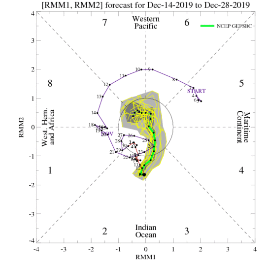
GEFS shows MJO skipping the maritime area and looping back to 1. Perhaps why it is not yet seeing the nasty Pacific.
EPS has a spaghetti bomb in the COD.
-
1
-
-
Just now, Orangeburgwx said:
"Int. 0z"
Sent from my A577VL using Tapatalk
Yes, he posted it earlier today, but the situation has not improved.
-
Just now, Orangeburgwx said:
Of all the flies in the ointment to have... The -PNA is the one that is the biggest slap in the face....
Sent from my A577VL using Tapatalk
-PNA and +EPO. Not so much a fly in the ointment as a buzzard.


Mid to Long Term Discussion 2019
in Southeastern States
Posted
Are you a day ahead of us in Easley?