

jm1220
-
Posts
26,172 -
Joined
-
Last visited
Content Type
Profiles
Blogs
Forums
American Weather
Media Demo
Store
Gallery
Everything posted by jm1220
-
For NJ it might not be too bad. East of the city these back door patterns are often raw and full of stratus. Hopefully not. And hopefully it can be short lived and the blocking is over done.
-
Looks like 2” for LGA and Central Park. Some of the short range models were showing a 2” area there and there was a local heavy rain band that parked overhead. Winds also gusted >50 over LI.
-
12” reported near BGM. If this was a month earlier there would be widespread 2 feet in upstate NY. As is there will probably be a decent number of 15” reports near where that crazy deform band parked. This is another example of how coastal storms mature later now. Heavy amounts in NE PA near the Poconos and upstate NY but not back into Central PA. It dryslots there too soon in these storms and the deform band forms too late/east. There are likely 6” or so amounts in high elevations there. Also some bad luck with it falling during daylight.
-
State College may have 30" for the season with this storm. Don't know how much they have yet from today but that's very lousy once again. The inland runners that do happen like today blow up too late now for central PA. 3/14/17 was good in central PA but was best in the Poconos and upstate NY. Once again with my 31.5" here I win. Could've been significantly better if we had the blocking coming up in Feb instead.
-
NE PA/Southern Tier of NY will get crushed later by that developing CCB. That’s good lord type intensity headed there, and at night so it’ll pile up. There’ll likely be a swath of 10-12” up there.
-
State College’s snow average was ahead of Boston by several inches in the 1981-2010 averages and went several inches behind with the new 1991-2020. Shows how cruddy it’s become there during our bonanza. They get the occasional good season still but no doubt something climactic has shifted to favoring these big coastal storms vs inland/huggers.
-
Don’t be. I’d rather be here for snow for the last 10 winters generally than anywhere in central PA other than orographically favored places. It’s a lousy place to live if you want major snow events.
-
Very nice event out in central PA for a change, too bad it had to come so late in the season. Hopefully the developing CCB can hold in heavy snow for a while. That’ll determine who can pile up to warning totals vs advisory. It’s always annoying when you’re snowing heavy and the dryslot comes in to shut it off after 3 hours which is a very frequent problem in PA.
-
Yep, whenever you see those troughs developing over the Maritimes this time of year you know what’s coming. Blocking at the worst possible time once again.
-
Didn’t miss much. Here it was a brief moderate shower amongst drops here and there.
-
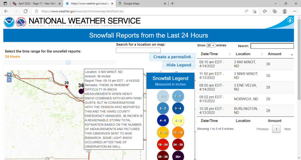
36" now just N of Minot.
-
Insane temp gradient right on the Sound. Huntington Bay is at 56 but a mile or two away in Centerport is 76.
-
Happens all the time in places like Long Beach. It finally warms up this time of year after the cold front passes and winds come from the land. So there it’s actually a warm front.
-
We’re nowhere near the back door for once. It’s well NE around the MA/CT border.
-
Eatons Neck at 53. Ouch.
-
77 here-summer like. Stuck at 57 just a few miles away on the Sound and also at Captree.
-
Yep, 70 now. Gorgeous here.
-
Brutal up there now and in MT where lows will be in the single digits. As wintry there in mid April as it ever gets here. Always fascinating to be in a blizzard especially a historic one like this in the region. They usually get 4-8” type storms not 2 feet. The drifting there must be absolutely insane. The heaviest amounts will probably be near Minot which is under the pivoting upper low.
-
68 right now. Overperformer on temps at least here on the north shore. South shore looks stuck in the 50s.
-
Looks like ND got NAM’d to an extent and had the heavy snow too far north. They’re in for a huge event across 80% of the state. Jealous. Very rare for them to get the kind of snow in one storm we get.
-
Big ND snow upcoming. Some places there likely 24". Bismarck has a tough forecast, riding the rain/snow/dryslot line. We'd be on pins and needles if we lived there. Delayed but not denied for ND, looks like mostly below average for snow this season. Bismarck has about as much as ISP this winter but they average 45" or so.
-
Possible if the seabreeze can be held off. You really need the west/NW wind this time of year for any warmth at the coast. Today was great here for once with temps in the mid 60s.
-
With the trough hanging strong east of here/the Maritimes it’s more likely than not we have a back door front at least nearby. They always seem to be more sweeping than advertised 4-5 days out as well.
-
What’s more likely is our climate becomes like the coastal Carolinas. You don’t hear about Charleston SC hitting 100 very often but they’re in the low to mid 90s all the time with atrocious humidity. We’re already at the point especially in August where the sea breeze doesn’t cool things down much, it just increases the humidity. We’re also at a longer term raised hurricane risk if the waters will keep warming up and the mean ridge position keeps coming north. It’ll mean a southerly flow into our area instead of the usual recurves out to sea. We’re seeing the overshooting heat waves into ME/Ontario already. It’s counterintuitive but when we’re hot with westerly winds, the waters cool down due to upwelling. Southerly onshore winds help the coastal waters warm up faster.
-
I wouldn’t say the storm last night was a bust. The heavy rain was always favored to be north and west of the city on the models. The first storm was somewhat of a bust. It dried up on the northern edge. You could say that NYC/LI were shafted relatively for both storms.


