jm1220
-
Posts
26,187 -
Joined
-
Last visited
Content Type
Profiles
Blogs
Forums
American Weather
Media Demo
Store
Gallery
Everything posted by jm1220
-
So far in Long Beach it’s just breezy. At this point if the winds don’t kick up they likely won’t. Just a nasty evening.
-
46mph at JFK. Oddly not too windy here. Gusts in the 30s I’d guess.
-
In Long Beach right now, breezy but no big gusts. Maybe some gusts to 30 or so.
-
The low did trend west. It’s tracking over PA and that’s where the wind threat came in from LLJ east of it. Some places probably will get 4” but probably eastern Suffolk and New England. More rain area wide would’ve been nice though given we’re still in a severe drought. Maybe this offshore convective stuff is robbing from what’ll pivot overhead later.
-
Some places in W Suffolk have 1” already, they’ll very likely end over 2”. This offshore slug off NJ will probably hit those east of Rt 111. West of there looks like has to wait for the stuff over E PA to come in. So that’s where the sucker hole that might get 1” happens.
-
I’m thinking the rain where the dry slot is now does fill in later but that’s where the lower amounts will be that some models have. We have to wait for the main heavy rain area with the low to move east. 1-2” is welcome of course but we need more. And we’ll see what the winds do this afternoon on the coast. Suffolk might get the worst of both worlds with 3”+ and 60 mph gusts.
-
It does look like there'll be a relative sucker zone between the heavier offshore stuff and the area inland where heavy rain trains for a while. 1-2" vs maybe 4".
-
Doesn’t seem to be much of an inversion with temps and dewpoints in the 50s. We’ll see. Hard to tell in advance sometimes if these wind events are overhyped or they produce.
-
Surprised there aren’t more posts about this. Models show a window for gusts 50-60mph+ tomorrow evening near the coast. It won’t snow but that’s enough to cause local power issues.
-
Rudolph moved to Hudson Bay?
-
Just as the snow got very heavy in Long Beach the R/S line surged north, the huge aggregates started and 10 minutes later all rain. The R/S line stopped dead on Merrick Rd for hours. I think I ended with 7" of slop but most of the rest of LI had 12+.
-
Nothing's worse than where I grew up for any winter event and even some better events for most like 2/13/14. I just happened to get a good deal on where I live now too.
-
I remember-that one had the wild development near Cape Cod that gave hours of thunder snow to E MA.
-
I was living in PA at the time-8" or so there. South shore in that one had zilch.
-
I’m hoping for a 7-10 day period where we can get something to happen like early in Feb when we had enough of a window for the 6-8” snowstorm I had. I highly doubt there’ll be a sustained favorable period with cold and a good storm track this winter, the Pacific jet will demolish anything that tries to set up. I’m counting on luck where I’m living. Of course in this Nina pattern we’ll probably get the SWFE train sooner or later where I-90 and north will rack up win after win while I get maybe a few sleet pellets before rain.
-
If we’re using the 3” metric for Dec snow and hope for a good Nina winter for NYC, hopefully we can get some kind of opportunity before the month ends. Right now it looks like crap at best. At least the rain is coming back. Long term droughts aren’t a thing here.
-
GFS would have 50-60+ mph gusts for NJ/LI Wed evening. Good thing the full moon isn't until 12/15.
-
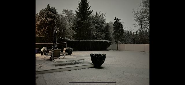
Last of the snow is melting in my backyard today. Was a nice little surprise event.
-
This time of year I’d say it’s something you do once or twice, or you want to go all out like getting a hotel room near Times Square for New Years Eve. I used to work near Grand Central and seeing it the first couple times was nice but after was just a PITA. It was pathetic seeing the Christmas/New Years setup in Austin when I lived there in comparison-really no one does it up like Midtown this time of year so it’s worth seeing it the once or twice.
-
BOS’s run of luck went dry. In the last 5 winters back to 20-21, my backyard 30 miles E of Central Park probably has the same snow on average as them. As much as NYC can’t get away with consistent 40” winters, BOS can’t get away with the 60-70” seasons they were getting and will revert back to their 40” or so long term mean.
-
The 2003 one was fun, as the Part 1 overrunning was supposed to change to rain and never did even on the south shore barrier islands. I had 8" or so from that when there was supposed to be 1-3" maybe before rain. The second part was OK where I live but where the banding could pivot around was epic and ended with 20"+. I think I ended with 13-14". 2002 was also, but it was more a general quick hitting 6-8".
-
That area is generally favored in a Nina for more snow so that’s a good sign for them. Here hopefully any cold we get is less modified.
-
Models seemed to have a better area of precip where I am/better lift which may have overcome the lousy wind direction and brought cold enough air down. Also urban heating tacks a few degrees on. I think the first few miles from any shore had little accumulation.
-
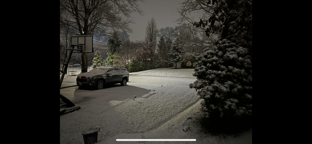
Burst of light snow just ended. Snow on pavement mostly melted but some slush left. There was a half inch or so when I took the pics overnight. I’ll go with what @NorthShoreWx says for final total lol but glad to see we’re on the board and it was unexpected since this is a storm on a southerly flow. I guess the land component was enough not to completely torch it?