RogueWaves
-
Posts
2,559 -
Joined
-
Last visited
Content Type
Profiles
Blogs
Forums
American Weather
Media Demo
Store
Gallery
Everything posted by RogueWaves
-

Winter 2024-25 Medium/Long Range Discussion
RogueWaves replied to michsnowfreak's topic in Lakes/Ohio Valley
Conversely, it has my area at 6-7 feet annually, lol I wish! More like 5 ft (or a bit under) -
I need 4.7" during this final week of the month to have an average January. Can these clippers pull it off?? Stay tuned!
-
Then he'll roll out pic's from the glory years to get thru it, lol
-
Hit a couple whiteouts in these firehose streamers heading home this evening. This clipper's been great for The Mitt
-
Winter 2024-25 Medium/Long Range Discussion
RogueWaves replied to michsnowfreak's topic in Lakes/Ohio Valley
Got my eye on those! -
Winter 2024-25 Medium/Long Range Discussion
RogueWaves replied to michsnowfreak's topic in Lakes/Ohio Valley
Last night by far. Seems any time a pro team in Detroit gets extra rest going into post-season its been the death knell. Odd how it was the same Washington club that beat us back in '91 the last time I was hopeful for the Lions. The crazy part is Washington's not done squat in all these years since either til 2025 - go figure! -
Fall/Winter '24 Banter and Complaints Go Here
RogueWaves replied to IWXwx's topic in Lakes/Ohio Valley
For your locale. If these were your options, which one do you take? 11/22/15, 1/5/14 PV Bliz, Dec '00 Bliz -
Winter 2024-25 Medium/Long Range Discussion
RogueWaves replied to michsnowfreak's topic in Lakes/Ohio Valley
Was so hopeful a Lions run at the Superbowl would tide us over until February to see if that month showed up as the rest of January apparently won't. Now, with last night's fiasco upset, I'm about ready to just concede this winter may be nothing more than we've already seen. Meager snows and melt-downs mixed in. -
Winter 2024-25 Medium/Long Range Discussion
RogueWaves replied to michsnowfreak's topic in Lakes/Ohio Valley
I've heard those spring lake breezes in Chicago are awesome -
A pair of days above freezing (34 & 39F) with some sunshine and warm breezes dropped an already modest 5" depth down to a much more dense 3-ish OTG. Unique to this was zero melting from below - was 100% off the top. Well frozen ground for the win in that regard. After working the morning shift, decided to tour the LES belts in NMI to remind myself what deep(er) winter looked like. Considering that region has seen 75-118" of snow already (mostly lake fluff) the conditions ofc were not the deepest due to the regular thaws. Still, no mistaking there's 12-20" depths and more snowmobiles than I'd seen in a long time. Even had enough post-arctic front LES to cause drifts out onto the shoulder of US131 in open areas around Mancelona. To date, Gaylord would normally have about 50" more on the season than Harrison. This winter its almost twice that. Unfortunate that the mini-thaw was working on the salt/sand in the snow banks along the highway leaving that nasty brown and I've seen a melt look. Otherwise, with the lakes having good ice, its a solid MLK winter holiday weekend in the Northland and boy the industry sure needed it after last winter.
-
Surprise 1.4" overnight and more starting around midnight tonight. Depth literally inching its way up with 5+ OTG. Best since 12/23 and looking a lot more like January should. Saturday looking good for SEMI. Will have to see whether the more north-including models are onto a trend. If so, it'd be a lot like last weekend's system.
-
Winter 2024-25 Medium/Long Range Discussion
RogueWaves replied to michsnowfreak's topic in Lakes/Ohio Valley
This was a major one
-
It's been nice to look out our windows and see solid white so much this winter compared to recent ones. 38 days with snow cover on 1/12 - not too shabby. I'm a snow cover/depth hound myself. Had a break here, but snow's about to pick-up again..
-
My forecast up until 24 hrs out, was for 1". Then they bumped me to 2" with a 10% risk of 3" which I ended up scoring. Late-game rally for the win! Had 1/2" this morning, and it's been on/off decent rates this pm. Stacking it at 27F
-
Year of the Clipper! Seriously. Posted before my confidence is elevated when these come my way. Finished on the over-achiever list with a solid 3" here.
-
Winter 2024-25 Medium/Long Range Discussion
RogueWaves replied to michsnowfreak's topic in Lakes/Ohio Valley
That table's been pretty wobbly this winter. CPC's odd map with the high winds swath south of us. wonder what they are thinking?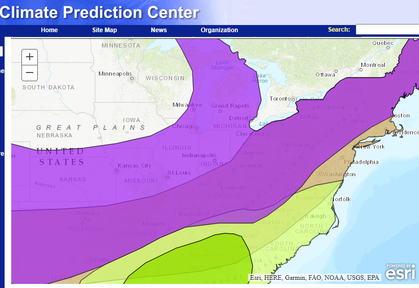
-
Not too much. I work in NMI, but live in Mid-Mich. With this little event, might have 1.5-ish now here in Clare Cnty. Much more at work ofc 45 miles north and at least on the edge of the snowbelt.
-
Were you expecting more out of this/them? LOL, I wish I had a headline.
-
Thanks, they're the ONLY thing that have delivered here in mby, so I'm quite optimistic actually. Also, this is not coming as much due south from the arctic dryness. Oh, and btw, whatever the NAM's smoking I wouldn't mind this for Friday either
-
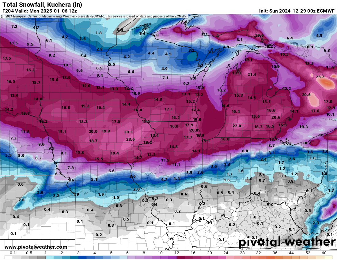
Ofc, I will gladly take any synoptic snow that Friday wants to deliver, but Sunday night/Monday clipper has my attention, and apparently GRR's as well: - Another snow event Sunday night into Monday Yet another low is forecast to move northeast into our area from the Mid Mississippi valley on Monday. Several inches of accumulation look possible with this system.
-
Dusting my way to 20"
-
Winter 2024-25 Medium/Long Range Discussion
RogueWaves replied to michsnowfreak's topic in Lakes/Ohio Valley
Lucky we at least have the Lions to help the zzz's -
I got what your original posting focus was, but others thought you just meant snowfall vs bigger storm winners/losers. 3/3/23 was my only quality storm in NW Wayne burbs during my 3 winters there fwiw.
-
You've done better than me up here, lol. Just under 2" fell, then strong winds have blown the lake fluff in any open area plus the usual fast compaction. If it weren't for clipper hits, I might have less snow than @michsnowfreak has to date.
-
Winter 2024-25 Medium/Long Range Discussion
RogueWaves replied to michsnowfreak's topic in Lakes/Ohio Valley
Uhm, SMI just had up to 2 INCHES liquid last weekend. Which is precip last time I checked. We've suffered horrible temp pattern as much or more than a lack of moisture.