RogueWaves
-
Posts
2,539 -
Joined
-
Last visited
Content Type
Profiles
Blogs
Forums
American Weather
Media Demo
Store
Gallery
Everything posted by RogueWaves
-
Lived in S. Bend for winters of 98/99/00/01/02. Five yrs when NW LES events were non-memorable if we even had one? Ofc, super Nino '98 was the first yr with like 72F in Feb. Got Jan of '99 and it's awesome bliz and a roughly 3 wk winter. I think Nov/Dec 2000 was the best period but again, not due to any historic LES events.
-

Winter 2024-25 Medium/Long Range Discussion
RogueWaves replied to michsnowfreak's topic in Lakes/Ohio Valley
So, Feb 2021 with 14" at DTW pretty sure that qualified, just not sure how it was up where you are? I was in Marshall for that one, and it was an intense 10" storm complete with some nice winds. -
Winter 2024-25 Medium/Long Range Discussion
RogueWaves replied to michsnowfreak's topic in Lakes/Ohio Valley
There's no arguing that. Most frustrating thing of my 3 winters in Wayne Cnty. -
Winter 2024-25 Medium/Long Range Discussion
RogueWaves replied to michsnowfreak's topic in Lakes/Ohio Valley
Begs the question "just what's worth flying home for?" I mean, 12+ not too common in Detroit region. -
I think S. Bend's moment looms..
-
Winter 2024-25 Medium/Long Range Discussion
RogueWaves replied to michsnowfreak's topic in Lakes/Ohio Valley
Weren't you in FL during that Feb 2021 storm? -
Winter 2024-25 Medium/Long Range Discussion
RogueWaves replied to michsnowfreak's topic in Lakes/Ohio Valley
Certainly, early in the season climo does NOT favor SEMI. Feb and March do. Still, MSP had their record season couple years back. I don't think they will own the magnet this winter. I think SEMI will do much better than recent winters and certainly better than last year. -
Winter 2024-25 Medium/Long Range Discussion
RogueWaves replied to michsnowfreak's topic in Lakes/Ohio Valley
Yep. DTW south to KTOL were in the jack zone. Typical when such an overwhelmingly cold pattern's in place. That's TOL's best and only real chance so I'm not upset if they score in such a pattern. Iirc, GHD-2 also treated them well. -
November 2024 General Discussion
RogueWaves replied to SchaumburgStormer's topic in Lakes/Ohio Valley
First time seeing a metric snowfall map for MI. Congrats on the LES pounding. But, did you not get buried during the Dec 2022 storm as well?? -
Winter 2024-25 Medium/Long Range Discussion
RogueWaves replied to michsnowfreak's topic in Lakes/Ohio Valley
Feels like a waste here so far. But clipper looms keeping hopes alive. -
Fall/Winter '24 Banter and Complaints Go Here
RogueWaves replied to IWXwx's topic in Lakes/Ohio Valley
He's both right and wrong. On this event you want to get inland (due to early season lake warmth) and the better elevations offer the best lift. Harbor Springs/Petoskey does well on a SW flow event, more so if the lake warmth isn't so strong that it forces the streamers to dump further inland. See Dec 2001 as the bench mark when Petoskey scored 84" in that early season historic LES storm. I may check out the Gaylord area tomorrow if I find time. Oh, and getting missed by 5 or less miles. LOL - welcome to LES Edit - and now I see APX's AFD: Lake effect snow lovers around Gaylord and Sault Ste. Marie, take note -- it is hard to draw up as perfect a set up as this, and it does not come around often. Many synoptic similarities described above can be actually be drawn back to the infamous 2001 Petoskey lake effect snow event -- where totals of 80" and unofficial amounts near 100" over a several day span were recorded. -
November 2024 General Discussion
RogueWaves replied to SchaumburgStormer's topic in Lakes/Ohio Valley
Had my 1st legit winter day and saw my first drifts - in Novi -
Winter 2024-25 Medium/Long Range Discussion
RogueWaves replied to michsnowfreak's topic in Lakes/Ohio Valley
Let the mood setting event commence..
-
Fall/Winter '24 Banter and Complaints Go Here
RogueWaves replied to IWXwx's topic in Lakes/Ohio Valley
Thx! Interesting colors -
Fall/Winter '24 Banter and Complaints Go Here
RogueWaves replied to IWXwx's topic in Lakes/Ohio Valley
It was cold and very snowy even in S Europe not too long ago. They're riding the same temp's regime coaster we are. -
November 2024 General Discussion
RogueWaves replied to SchaumburgStormer's topic in Lakes/Ohio Valley
I'm heading the opposite direction Friday, but the lake looks to finally produce just north of here per APX: Significant snowfall accumulations are expected in the usual snow belts of northwest lower and eastern upper, particularly during the Friday into Saturday time frame. Moisture appears to be very robust during that time and forecast model soundings look phenomenal with inversion heights through the roof (or in this case 20,000 feet+). The dendritic growth zone (dgz) which is between -12 and -18 C would be entirely in the sounding promoting large snowflakes which would stack up nicely. Actually, I can`t remember seeing soundings reaching this magnitude for this long of a time period (60-72 hours+). The mean steering flow looks to lock in out of the west northwest but embedded short waves could cause the flow to waver a bit from time to time. Either way, would not be surprised if one to one and a half feet or more of snow falls in some areas during that time. In addition, gusty winds later in the week could lead to considerable blowing and drifting snow. Post Thanksgiving Day travel could become risky at best with near zero visibility likely at times in the snow belts. -
Winter 2024-25 Medium/Long Range Discussion
RogueWaves replied to michsnowfreak's topic in Lakes/Ohio Valley
Yep. Been a lot of late Nov's that looked much worse for our winter ahead. -
Let’s talk winter!! Ohio and surrounding states!! 24'-25'
RogueWaves replied to buckeye's topic in Lakes/Ohio Valley
Hmm.. so this calls it a blizzard, not just a cold wave.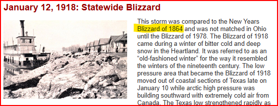
-
Let’s talk winter!! Ohio and surrounding states!! 24'-25'
RogueWaves replied to buckeye's topic in Lakes/Ohio Valley
That's what I figured. News reports/urban legends written in diaries, etc would be the info source vs actual wx site data at that distant time period. It's amazing how extreme some of those cold waves were back in the "pioneer" era of the Midwest. 1864 was lumped in with the two bliz events based on impacts to life. I just presumed it to be via snow/wind but not always obv. -
November 2024 General Discussion
RogueWaves replied to SchaumburgStormer's topic in Lakes/Ohio Valley
Hope so for your sake. Completely donut holed here. NOT A FLAKE. 2013-14 started this way for me so not too worried at this point.. -
November 2024 General Discussion
RogueWaves replied to SchaumburgStormer's topic in Lakes/Ohio Valley
Let it snow! A tiny change in the expected BL thermal fields tonight would result in big changes to expected snow amounts. For now, have 2-5" for GLR/Mio/HTL/CAD. The highest amounts are near GLR/ Grayling/Mancelona. Little/no snow accums expected in eastern upper MI, or along the very immediate Great Lakes shorelines. A wide range of snow solutions remains possible. Given that this is a 2nd into 3rd period snow event, and given our office policy/approach, will not be issuing advisories at this time. But at this time, feel that advisories are likely to be needed over the interior of northern lower MI. -
Let’s talk winter!! Ohio and surrounding states!! 24'-25'
RogueWaves replied to buckeye's topic in Lakes/Ohio Valley
Certainly an arctic front came through, and maybe clashed with moisture just south of those cities down in Ohio. It wouldn't have had staying power after 1918 and 1978 if it wasn't in the same league. -
November 2024 General Discussion
RogueWaves replied to SchaumburgStormer's topic in Lakes/Ohio Valley
Nice to have you looking out for this region. I presume you're a student at CMU? -
Let’s talk winter!! Ohio and surrounding states!! 24'-25'
RogueWaves replied to buckeye's topic in Lakes/Ohio Valley
Any of you Buckeyes have more info on the 1864 bliz? Been curious about it for yrs tbh. Ohioans who lived through the "Great Blizzard of '78" will never forget it. It is engrained as part of each person's "Ohio Experience", a legend to be told to their children and grandchildren. This storm was compared to the Blizzard of January 1918 and the New Year's Blizzard of 1864 for ferocity and disruption to everyday lives. -
November 2024 General Discussion
RogueWaves replied to SchaumburgStormer's topic in Lakes/Ohio Valley
Just lived thru the sunniest Sept/Oct I ever remember in the Northland. And you want to flee The Mitten so fast??