Gravity Wave
-
Posts
1,170 -
Joined
-
Last visited
Content Type
Profiles
Blogs
Forums
American Weather
Media Demo
Store
Gallery
Everything posted by Gravity Wave
-
Forget the exact temps, if you told me we'd only be running 0.1 degree colder than Baltimore for the winter I could've pretty much guaranteed a bad winter.
-
That's because they also got hit hard by the February 10 storm, which seems to be largely forgotten today despite being the most impressive event I've ever personally experienced (too young to remember 1996 and was in upstate NY for 2016). We got 18" of snow (after compaction, which was likely significant because the temp was 32 degrees for the whole storm) IMBY in Allentown in about 5 hours. It saved the winter for me since we got skunked by 12/19, 2/6 and Snowicane that year. I still wonder what would have happened if we'd had a better airmass for that storm or if it hadn't been in such a hurry to leave.
-
Would be great if the Nino could break some of the stuck patterns of the last 6-7 years (endless SE ridge, NW Atlantic warm pool, eastern Pacific cold pool).
-
Looks like a potential chance at D10, which corresponds with a trough swinging through the east that the ensembles are now showing.
-
RGEM and CMC have a warm/amped bias. If they're the only models showing an event as all rain, you shouldn't be too worried.
-
Loud thunder in Manhattan, and now heavy rain.
-
There is a coastal signal for the 31st on the 12z GEFS, although it appears to be too warm for the coast. This is the next threat after the 25th-26th, and possibly the only one that will occur during our brief "improved" pattern.
-
The 25th/26th threat is very close for the coast according to the Euro. Every small shift south with the 1st storm, even if it's going to be a rainer for NYC, will help our cause for the second one.
-
Euro has a bomb at D9, looks good for the coast. Could this be our season saver?
-
I don't think that's really true anymore. What I will say is that the 18z and 06z GFS use the same data as the 12z and 00z runs, respectively, so they are a little less interesting for that reason.
-
There's definitely less heartbreak like this, but in a way it's almost more psychically damaging. At least in a near miss situation you can tell yourself that you just need one or two more things to work out the next time, in the pattern we've had there isn't even room for any wishful thinking.
-
I don't think we've had a single meaningful threat survive to the D7 mark (168 hours) this year. The Christmas bomb was clearly cutting by that point and today's threat was a goner after a few interesting runs last week.
-
Back when the Euro was the undisputed King, people called it Dr. No because it would almost always shoot down whatever fantasies the GFS, NAM and Canadian would spit out, and all but the biggest weenies would take it to the bank. But on the rare occasions when it did show something big inside 5 or 6 days, you knew it was time to get excited. All of that died after January 2015 of course, and since then no model has come close to getting that level of respect (at least for forecasting east coast winter storms).
-
Actually we haven't even had much fantasy eye candy this year, which contrasts with our other recent bad winters where we've frequently been teased.
-
The late January pattern change doesn't appear to be getting pushed back yet on the models. Does anyone think that the relatively Nino-like attributes of the current pattern make a typical (i.e. bad) Nina February less likely?
-
In Pittsburgh for Christmas, really crazy conditions out here. -5 in the middle of the afternoon with 50 mph gusts, absolutely wild and incredibly cold. Near whiteout-conditions on the turnpike from blowing snow, and that was from just a few inches of accumulation. Some stations in the northern part of the state hit blizzard conditions.
-
Don't look now but the ICON is taking a significant step towards the GFS with its handling of the shortwave through 75...
-
NYC proper got 6-8" from a storm in mid-December 2020.
-
12z CMC has the pre-Christmas threat.
-
Things are definitely heading back in our direction after yesterday's scare. Given how this has developed so far I'm expecting more curveballs.
-
This website has a ton of info about every winter storm of any significance to strike this region from 1993-2013. The writeups and snow maps are NJ-focused but there are a ton of other resources (radar imagery, surface maps, pressure/temp maps from various levels, regional station observations) for the storms. Ray's Winter Storm Archive (raymondcmartinjr.com) As for the millennium storm, I've linked that page below and it seems there was a weak, dying low over Lake Erie that transferred to the NC coast. Snow storm, December 30, 2000 - Storm Summary (raymondcmartinjr.com)
-
The last clipper I remember was in January 2010 right after the New Year when I was still in Allentown. Was supposed to be a 2-4" event, ended up with a dusting.
-
I had my AC on last night as well.
-
I'd guess that or February 10-11, 2010.
-
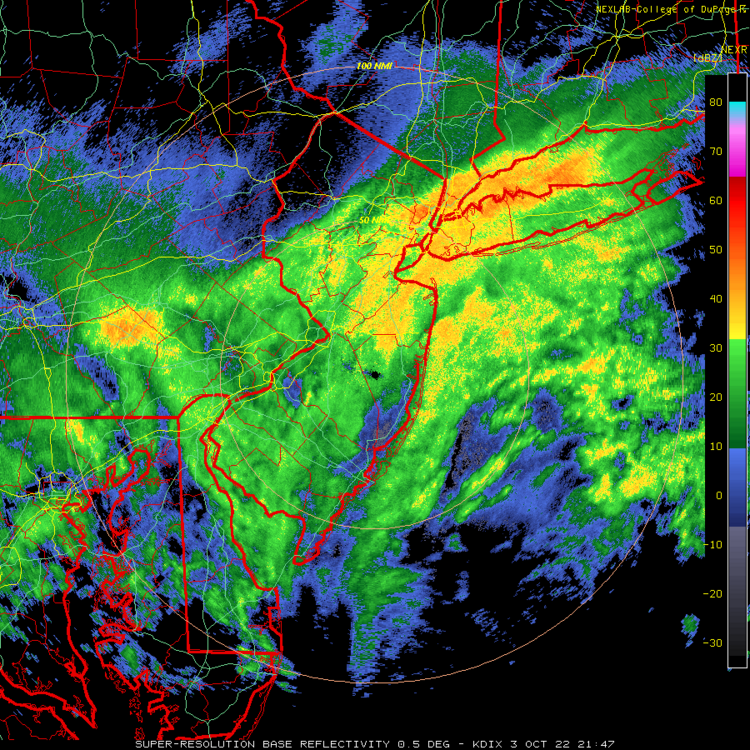
Let's get this exact same radar image in 10 weeks, please.