Chicago WX
-
Posts
18,395 -
Joined
Content Type
Profiles
Blogs
Forums
American Weather
Media Demo
Store
Gallery
Everything posted by Chicago WX
-

1/24-1/25 Major Winter Storm - S. IL, IN, and OH
Chicago WX replied to A-L-E-K's topic in Lakes/Ohio Valley
Bingo. If we’re compared short range models, 18z RAP looks to be handling things better. -
1/24-1/25 Major Winter Storm - S. IL, IN, and OH
Chicago WX replied to A-L-E-K's topic in Lakes/Ohio Valley
Light snow has started here. -
1/24-1/25 Major Winter Storm - S. IL, IN, and OH
Chicago WX replied to A-L-E-K's topic in Lakes/Ohio Valley
I think LOT’s call for 3-5” is good. Not sure there’s any room to go beyond unless we get under some banding and ratios really go nuts. I just want some snow to cover the landscape if we’re doing this big cold thing thru next week. -
1/24-1/25 Major Winter Storm - S. IL, IN, and OH
Chicago WX replied to A-L-E-K's topic in Lakes/Ohio Valley
LOT goes WWA for a bigger chunk of the CWA than I expected. IKK zone text has 3-5" total. I guess its part good ratios and then banking on LES closer to the lake. NW ticks been the theme of the models since 18z yesterday. Even the 6z GFS/GEFS came in a bit farther northwest. I mean not wholesale changes, but decent increases on the northern fringes. I guess we'll see. -
1/24-1/25 Major Winter Storm - S. IL, IN, and OH
Chicago WX replied to A-L-E-K's topic in Lakes/Ohio Valley
Versus its "not happening 18z run", sure. But its farther north compared to the 12z run, especially in S/C IL, N KY, S/C IN, into OH and SE MI. Spot in KY went from 18" on the 12z run to 5" on the 0z run. -
1/24-1/25 Major Winter Storm - S. IL, IN, and OH
Chicago WX replied to A-L-E-K's topic in Lakes/Ohio Valley
0z HRRR will a sizable jump north/northwest compared to its 18z run. Though, it seemed to be maybe too far south with its 18z solution. And of course, spots of 10" or a bit more for the lakefront with LES. Take it to the bank clock?
-
1/24-1/25 Major Winter Storm - S. IL, IN, and OH
Chicago WX replied to A-L-E-K's topic in Lakes/Ohio Valley
I was holding out hope that the euro was going to be right, but every run erodes more and more of the northern edge. GFS took it to the woodshed on that aspect. Final call for myby is mood flakes through dim sun. Great start to this winter, but it went kapoot after that. Can’t end soon enough. Regardless, good luck to those to the east and south. Hope it over performs. -
1/24-1/25 Major Winter Storm - S. IL, IN, and OH
Chicago WX replied to A-L-E-K's topic in Lakes/Ohio Valley
DT was the best. Going way back to the WWBB days. His call though, that is way far north. Especially in the OV thru NE. I know he loves the Euro, but I'm not sure its that zonked. -
1/24-1/25 Major Winter Storm - S. IL, IN, and OH
Chicago WX replied to A-L-E-K's topic in Lakes/Ohio Valley
Nah, you've always been optimistic. Never change. Need people like you to counter balance the wrist-slitters. -
1/24-1/25 Major Winter Storm - S. IL, IN, and OH
Chicago WX replied to A-L-E-K's topic in Lakes/Ohio Valley
Its better than the 12z run. But, no idea if the Ukie has been worth a sh*t. Let alone an 18z run. -
1/24-1/25 Major Winter Storm - S. IL, IN, and OH
Chicago WX replied to A-L-E-K's topic in Lakes/Ohio Valley
RGEM and NAM starting to bring GHD I northwest, right about this time, if I recall correctly... Just kidding obviously. But, why the angst over the GFS? Seems the Euro (and EPS) has kinda latched onto its idea of the system evolution. I'd ride its solution over anything else right now. -
1/24-1/25 Major Winter Storm - S. IL, IN, and OH
Chicago WX replied to A-L-E-K's topic in Lakes/Ohio Valley
This piece of crap is supposed to replace the NAM at some point, I believe. But hey, dare to dream.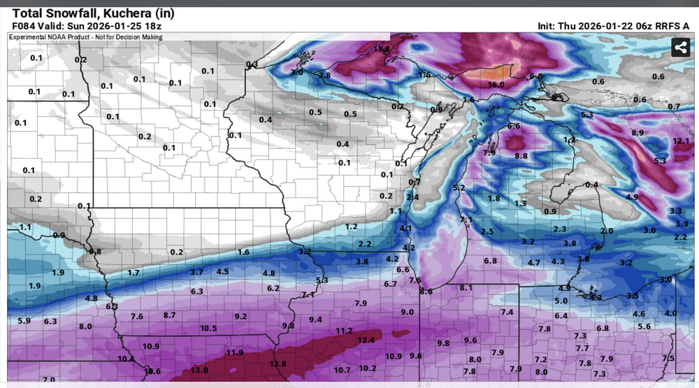
-
1/24-1/25 Major Winter Storm - S. IL, IN, and OH
Chicago WX replied to A-L-E-K's topic in Lakes/Ohio Valley
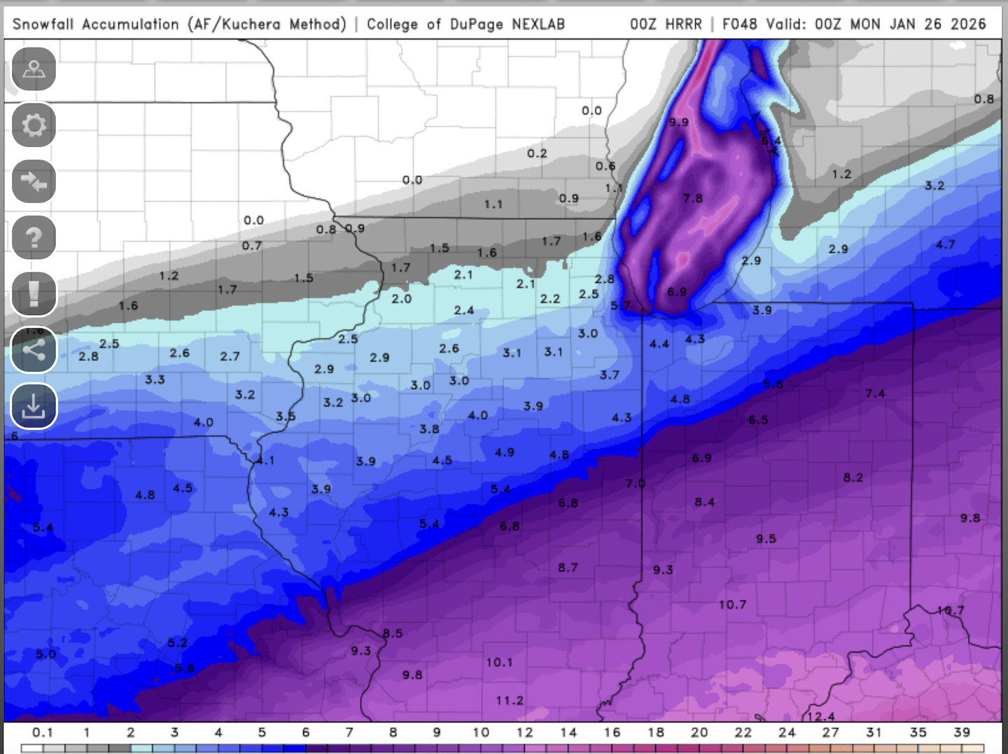
0.20-0.30" of QPF on the ensembles. Think my call right now would be 24 hours of arctic sand for a grand total of 2-4". 6z NAM with a classic jump way north. Sell as usual. I noticed on the 0z Euro, the 850 low gets pretty far north. Ends up flipping places like DC to pingers and zr after an initial thump of snow. SGF to BMG to CMH looking pretty locked in for 10"+. -
1/24-1/25 Major Winter Storm - S. IL, IN, and OH
Chicago WX replied to A-L-E-K's topic in Lakes/Ohio Valley
At this point, yeah. 6z Euro bumped north again. -
1/24-1/25 Major Winter Storm - S. IL, IN, and OH
Chicago WX replied to A-L-E-K's topic in Lakes/Ohio Valley
Kinda gives me Jan 1999 vibes. Big moisture laden system running into an arctic airmass. Snow field with that one was very expansive. Yeah, I'm not calling for a repeat at all, just saying the "similarities" as currently modeled. And probably a good sign that Alek has gone from congrats Greensboro to congrats NYC. -
Winter 2025-26 Medium/Long Range Discussion
Chicago WX replied to michsnowfreak's topic in Lakes/Ohio Valley
Extended looks good to me. To varying degrees, op runs have shown an overrunning type set up somewhere in the region. Obviously the biblical 18z GFS isn't happening, but the EPS and GEFS have been flagging that period (around Jan 23-?) for something to move through. One piece, two pieces...who knows at this point. I mean its our best shot at something other than northern stream dusters. First shot all winter really. And it certainly looks cold in the medium/extended range as well. Seems like it may be a bookend winter. Fast start, then zzzzz, and top it off with a good finish. -
Winter 2025-26 Medium/Long Range Discussion
Chicago WX replied to michsnowfreak's topic in Lakes/Ohio Valley
Could you imagine getting 28" and feeling screwed because 30 miles away got 4 feet? That one's a keeper though for parts of IL, IN, and OH. Can't recall a model run spit out something like that with one system. -
If you could re-experience ONE winter event....
Chicago WX replied to cyclone77's topic in Lakes/Ohio Valley
But to the original topic of the thread, it’d be January 1979 for me. I was only 3, so needless to say, no recollection of that one. It was of course the cherry on top of an incredible season in NE IL that winter. Second place would be Jan 1978, even if the snowfall amounts/impacts were lesser around here. I’d just love to see the evolution of that storm on present modeling. -
If you could re-experience ONE winter event....
Chicago WX replied to cyclone77's topic in Lakes/Ohio Valley
Iowa State has NWS text data back to 1983. Seems the snow amounts above 6" were a bit of a surprise for LOT forecasters with this storm, reading back through the AFDs, but forecasting was a bit more "primitive" back in those days. A few SPS's from LOT during this storm. The part about shoveling your driveway in the second one is gold. SPECIAL WEATHER STATEMENT NATIONAL WEATHER SERVICE CHICAGO IL 5 45 PM CST TUE DEC 15 1987 ...WINTER STORM WARNING CONTINUES FOR THE CHICAGO METRO AREA THIS MORNING AND TODAY... ...JUST WHEN YOU DIDNT THINK IT COULD GET ANY WORSE... AT 5 30 HEAVY SNOW...WITH OCCASIONAL VISIBILITY NEAR ZERO...WAS OCCURRING. MANY REPORTS OF THUNDERSTORMS...SOME WITH HAIL...AND FIERCE WINDS HAVE RECEIVED. AT 5 06 AM...OHARE REPORTED A WIND GUST TO 64 MPH...AND WINDOWS WERE BLOWN OUT AT SOME OF THE BUILDINGS AT NORTHERN ILLINOIS UNIVERSITY IN DEKALB. RADAR SHOWS YET ANOTHER LINE OF THUNDERSTORMS STRETCHING ACROSS THE SOUTHERN PORTIONS OF THE CHICAGO AREA...FROM JUST NORTH OF MARSEILLES TO CHICAGO HEIGHTS. THIS LINE IS RACING NORTH AT ABOUT 60 MPH AND WILL SWEEP ACROSS MUCH OF THE CHICAGO AREA OVER THE NEXT HOUR OR SO. DANGEROUS TRAVEL CONDITIONS...SUCH AS NEAR BLIZZARD CONDITIONS... AND HAZARDOUS ROADWAYS...WILL CONTINUE TO BE A PROBLEM THROUGHOU"T MUCH OF THE MORNING FOR CHICAGO. PLEASE CONTINUE TO STAY TUNED TO RADIO...TELEVISION...OR NOAA WEATHER RADIO FOR UPDATES ON THIS STORM. PURPURA SPECIAL WEATHER STATEMENT NATIONAL WEATHER SERVICE CHICAGO IL 8 00 AM CST TUE DEC 15 1987 ...WINTER STORM WARNING CONTINUES FOR THE CHICAGO METRO AREA THIS MORNING AND TODAY... AT 8 00 AM...MODERATE TO HEAVY SNOW WAS STILL FALLING ACROSS NORTHER ILLINOIS BUT HAS LET UP A BIT SOUTH OF PEORIA. WINDS STILL CONTINUE TO KICK UP SNOW REDUCING VISIBILITIES TO A HALF MILE OR LESS ACROSS THE ENTIRE STATE. WINDS WERE STILL FROM THE NORTHEAST IN THE CHICAGO AREA BUT HAVE TURNED TO A MORE WESTERLY DIRECTION SOUTH AND EAST OF THE CITY. THESE WINDS WILL SHIFT WITHIN THE NEXT COUPLE OF HOURS BUT WILL STILL MAINTAIN THEIR STRENGTH. IF YOU SHOVELED YOUR SNOW ON THE WEST SIDE OF YOUR DRIVEWAY TO AVOID BEING BLOWN BACK...YOU ARE IN FOR A REAL DISAPPOINTMENT. WINDS WILL FLIP AROUND 180 DEGREES AND ITS BACK TO THE DRIVEWAY WE GO. ON SLIPPERY ROADWAYS WITH POOR VISIBILITY...TRAVEL CONDITIONS AND LESS THAN IDEAL. NUMEROUS ACCIDENTS HAVE BEEN REPORTED THIS MORNING AND NO IMPROVEMENT IS EXPECTED UNTIL LATE THIS MORNING OR EARLY AFTERNOON. IF YOU CAN LEAVE A LITTLE LATER TODAY..DO SO. IF NOT USE AS MUCH CAUTION AS POSSIBLE AND LEAVE A LITTLE EARLIER FOR YOU DESTINATION. PLEASE CONTINUEv TO STAY TUNED TO RADIO...TELEVISION...OR NOAA WEATHER RADIO FOR UPDATES ON THIS STORM. BRUMER -
Herscher CoCoRaHS pretty much sums it up in their note this morning. They're a terrible snow measurer based off past history, but this location is pretty rural and they were reporting 1/16 visibility around 7:45 am. Probably could have used a WWA considering conditions were deplorable this morning. It doesn't take much snow with these winds. I have 6"+ drifts in my backyard. Still snowing here and a bit breezy... Swapped gauges at 5:10 pm, had 0.84 inch of rain at that time. Now just a trace of snow in gauge but probably not representative due to high winds gusting 38-49 MPH (33-43 KT) all night, gusting 41 MPH (36 KT) currently at KIKK AWOS. I would guess about 2 inches of new snow/snowpack depth with lots of drifting and blowing. Visibility 291347Z 1/16SM SN BLSN
-
Legit nasty conditions this morning. A little surprised with the good dendrites with the high winds, but we have been in the good reflectivities. Tough measure though with it blowing around. Some spots have 2", others have 0.5", and so on and so forth. We'll call it an inch I guess. Regardless, everything covered up again and winter has come back for a bit.
-
December 11th-14th Double Banger Clippers
Chicago WX replied to Jackstraw's topic in Lakes/Ohio Valley
Congrats to the central IL and IN peeps. 3.2" here, which is pretty good. Brings my total to 22.0" for the season. A phenomenal start. See you all sometime in January, when hopefully the next good/great snowfall pattern emerges... -
December 11th-14th Double Banger Clippers
Chicago WX replied to Jackstraw's topic in Lakes/Ohio Valley
Rip city here. Everything has gone to sh*t. Looks like we got lucky and was far enough “south” to get into some good banding. Probably won’t last long, but it’s nice to have received… -
December 11th-14th Double Banger Clippers
Chicago WX replied to Jackstraw's topic in Lakes/Ohio Valley
1.0" of pure fluff here overnight. Where did that come from? Hopefully we can pull something out of thin air again tomorrow. 1-2" is probably the top end, but with temps in the single digits, well, arctic appeal for sure. -
Winter 2025-26 Short Range Discussion
Chicago WX replied to SchaumburgStormer's topic in Lakes/Ohio Valley
Need 2.2" to hit 20" for the season. A couple of days ago, thought that was a lock between the two waves. Now, better chance at not seeing a flake from both. Pulling for the folks in central IL/IN. Hope these systems overachieve for you.