Chicago WX
-
Posts
18,395 -
Joined
Content Type
Profiles
Blogs
Forums
American Weather
Media Demo
Store
Gallery
Everything posted by Chicago WX
-
Well, true. Think I almost jack potted in that disaster. Alas, I still like where Hawkeye, cyclone, etc sit right now on the modeling. But, still a bit of time to go to figure things out.
-
Who cares what the GFS shows. At this point, you guys are pretty much locked in. Enjoy.
-
0z RGEM looks fantastic though.
-
0z NAM looks pretty close to the 18z Euro. Shades of the past of the old EE rule? These days though, the NAM is worthless and the Euro is shaky at times. But, can't ignore the consistent moves NW by the Euro. If I was a betting man, I'd still side with it versus the other models. Iowa, N 1/4 IL, S 1/2 WI on east thru MI looking good right now.
-
18z RGEM was really nice. Seems the canadian suite are on the "stronger" train at the moment.
-
12z GEFS are better (wetter) than the OP. Good runs from the 12z EC, GGEM, and UK. Still think its a 3-5/4-6" system for most, but probably some higher lollipops in spots too. Think this will be a nice kick off to a fun upcoming pattern.
-

Winter 2024-25 Medium/Long Range Discussion
Chicago WX replied to michsnowfreak's topic in Lakes/Ohio Valley
Nah, north of your line is in play too. Just loop the ensembles. GEFS, EPS, etc. It's a pretty good parade of systems coming through our region every 3-4-5 days. Just taking the 12z EPS through 9/10 days: it's this coming Wednesday, next weekend, and then next Tuesday/Wednesday. Details TBD, but I think quite a few us are in play for good snowfall in the next couple of weeks. Just takes one to phase in a piece or good chunk of the PV, and it's boom. No guarantees on that of course, but it's not improbable. Next weekend on the 12z EPS. Pretty good agreement. Granted we would like the mean farther northwest a bit, but there are left leaners.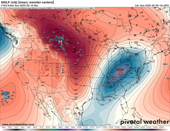
-
First real attempt by the NAM, and it's at least not taking it to Fargo. For real though, looks pretty similar to other models at this point. Kind of gives me a 12/8/2005 vibe with this system. Quick moving, but could rip pretty good for 3-5 hours outside a general 10-12 hour snow.
-
Winter 2024-25 Medium/Long Range Discussion
Chicago WX replied to michsnowfreak's topic in Lakes/Ohio Valley
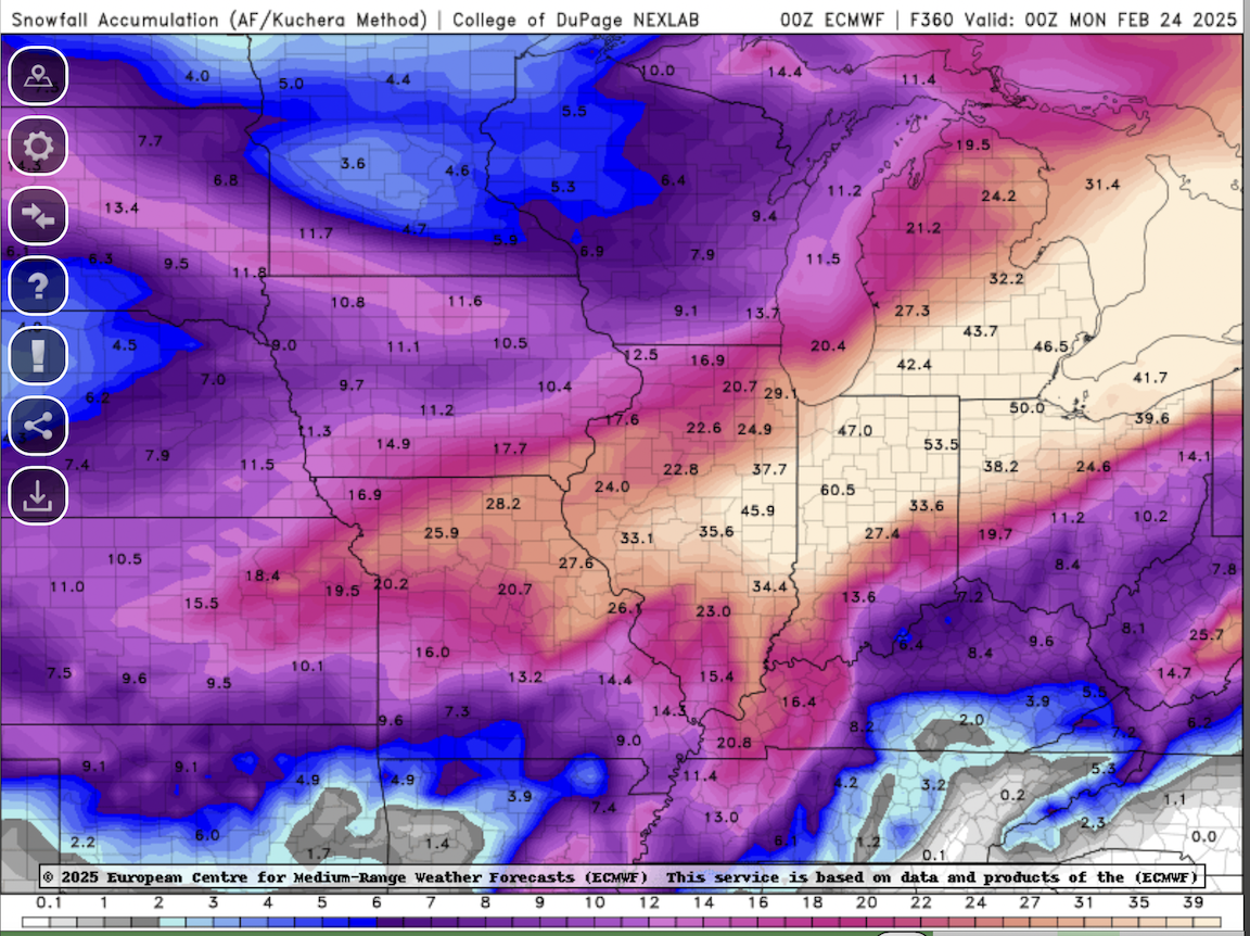
This is like hitting black jack 7 hands in a row. Hovering the cursor, there's a 61" showing up in and around the LAF.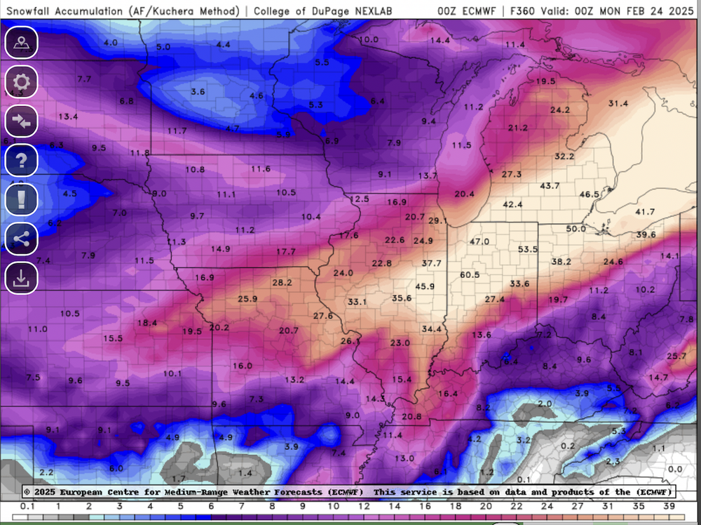
-
Long time no see. Pretty good agreement at this point amongst the op models/ensembles for a 3-5/4-6 type system. Maybe/hopefully we can get it to juice up a bit as it gets closer. I think the next weekend deal has a taller ceiling than this first storm. And then the EPS has another potential 4-5 days after that one. Best chance the region has had for a really good stretch of snows since Feb 2022. Hope it all works out.
-
My dogs love it. -3 right now. Winds ripping. Snowing. And they’re laying in the backyard in the snow. Have to beg them to come in.
-
The 5.8" is my report. Combination of the morning and overnight snowfall. 7.5" in Bourbonnais seems a bit high, but like vortex said, they're usually conservative. Most snowfall observers around here haven't the slightest clue what they're doing. Anyways, work was a beach today. Westside of IKK had 4-5 foot drifts. Some houses entirely surrounded by those drifts. Quite a challenge for me. And wicked conditions tonight with the snow, wind gusts close to 40 mph, and single digit temps. Arctic fun.
-
Woof. We made it out with snow cover, though nothing like what was around this morning. It's a gloppy mess that is about to become a glacier. When the rain hit, it became some of the worst working conditions I've had in quite awhile. In the end, the morning was fantastic...the afternoon was horrific.
-
We shall see. No matter, event already exceeded my expectations. Knew we’d get some front end action, but didn’t expect this much.
-
3.5" at my 6:00 measurement. Still ripping with good flake size. Only about an hour to go. Temp up to 32º. Latest HRRR and RAP says we're pretty much done after this band swings through, with temps getting into the 40's and then rain for the rest of the event. Hopefully we don't lose all the snow cover, but it's gonna be dicey. Alas, I'm pleased with this mornings snowfall...didn't expect it honestly.
-
Ripping. Went out and measured 2.0" on my board. Temp at 30º. Great start to this one.
-
Good old NAM. Here I was about to give it credit after seeing the 18z Euro, and then it does this...
-
All of the models have this feature. Look at the animations a couple of posts above. 18z Euro is a little different, in that it has the western low going farther north, like the NAM has been showing. Regardless, kinda interesting how they all have a changeover moving from east to west, to varying degrees. 18z HRRR was kinda the first show this. And then the trough feature that Joe pointed out. I've been out of the main show for a couple of days, but it'll be interesting to watch this all unfold.
-
Turn it up
-
That's life riding the southern edge of winter storms. Need the buffer zone down by CMI 12-24 hours out, instead of over our heads. Lack of good cold didn't help either. Writing was on the wall a couple of days ago. Better luck next winter.
-
Toss the RGEM. It was awful with the last storm. Suffers from the same cold/snow bias in marginal systems as other models. I knew it was gonna get cold after this storm, but looked at my p&c and it has 0 for a high on Tuesday. That's gonna suck with no snow on the ground. At least the standing water in the yards will be skate-able.
-
18z NAM is 0.0" for IKK surrounded on all sides by some accumulation. Perfect. Though honestly, best part is it and the 3k limit the heavy rain to like 0.50-0.75". Can't take much more rainfall around here. River is high. Yards still with standing water from the last deluge. EDIT: Eh, NAM dumps close to an inch of rain in the end.
-
-
12z Ukie is pretty far east. Jackpots northern Indiana and SW lower MI. FWIW of course… 12z Canadian models went north/west in their runs.
-
That’s typical though, right? But nah, my contention is throwing away the snowfall output, particularly for this area. GFS always too “cold”. And when you’re on the very southern edge of depicted snow, well you know how that goes 99% of the time. It’s gonna be a cold heavy rain here with a few flakes at the tail end. Farther north and west, looks good. My thinking for most of NE IL north of I-80 has been 6-10”. Hopefully it overachieves for them.