

Chicago WX
-
Posts
18,395 -
Joined
Content Type
Profiles
Blogs
Forums
American Weather
Media Demo
Store
Gallery
Everything posted by Chicago WX
-
Stopped at my house and measured. Total weenie move, but whatever. 2.5” so far. Still dumping. Got very very lucky here.
-
Rip city here for the past 30 minutes and still going. Flake size back to good, visibility about a block currently. I’m pleased.
-
I have a nice vantage point on my route on the southwest side of the city. Neat seeing the distance disappear as the snow got closer. Flakes size has been really good here to be honest. Every flake is sticking. Hopefully we can squeeze out an inch or two out of this whole mess. Regardless, I always enjoy seeing snow. EDIT: I see LOT updated and said snow quality south of I88 is poor, which of course is not true here right now.
-
That was like 24 hours ago. And just the NAM and one forecaster. Talking freezing rain. Alas, looking good 2-4” of sand. Enjoy!
-
We ride.
-
lol, we haven’t been setting records over here either. Just thought it was funny seeing the comment and then looking at the map of 12-18” across the southern half of lower Michigan. All the while I was just super ecstatic with my 8.3”. Which I’d take, but you know…
-
Well, it’d make southern lower Michigan people happy, that’s for sure.
-
Low floor, high ceiling. But this probably won’t be for the faint of heart. I’ll probably check back in on Friday.
-
I think there’s a decent chance that a good part of Illinois is fighting for 1-3” tops. Northern 1/4 (QC, RFD, ORD, etc) should be fine (3-6”) but they’ll have the mid-level low snows to depend on, while the rest of us are banking on the main low which looks to develop slower and farther east than earlier predicted. Models really hitting this idea right now.
-
Seems models have gotten worse these days. Maybe too models and too many model runs? Feels like back in the day you could count on their depiction 3-4 days out, with some relative minor corrections as you got closer. Now its wholesale changes 24-36 hours out. Euro especially has become undependable, unlike the past. Used to be ironclad. Now it's like the 51 hour RAP. Oh well I guess. My original thoughts with this one were a 3-5/4-6" type system. Might be more like 1-3/3-5" at this point.
-
18z GFS ticked northwest. I mean, I'm not surprised.
-
Well, LOT/Izzi is going with warmest/farthest northwest model (NAM) for this system. Kind of a bold call, but what do I know. There has been a bit of a northwest jog in the track of this system in this morning`s guidance, most notably in the NAM. Often times in strong warm air advection regimes, the NAM ends up being closest to reality with how far north the snow/mix/rain line gets, so did lean a bit more toward the NAM solution bringing some freezing rain and sleet north into our far southern and southeastern CWA.
-
12z UKie still farther southeast and weaker. Uncle not yet drunk.
-
Not sure if that hurts or helps the NAM. Terrible model really.
-

Winter 2024-25 Medium/Long Range Discussion
Chicago WX replied to michsnowfreak's topic in Lakes/Ohio Valley
Canadian and ICON, what could go wrong? Again, this is *weenie* total for both systems.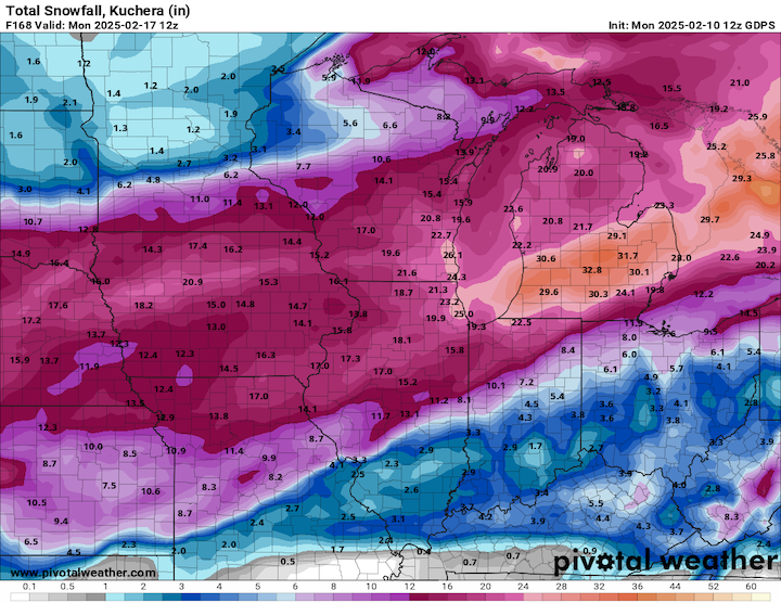
-
Winter 2024-25 Medium/Long Range Discussion
Chicago WX replied to michsnowfreak's topic in Lakes/Ohio Valley
Not even sure this is worth posting, but one can always dream. The 12z ICON really goes to town across E IA, S WI, N IL, thru MI with the weekend system. This would be the *weenie* totals from both systems this week.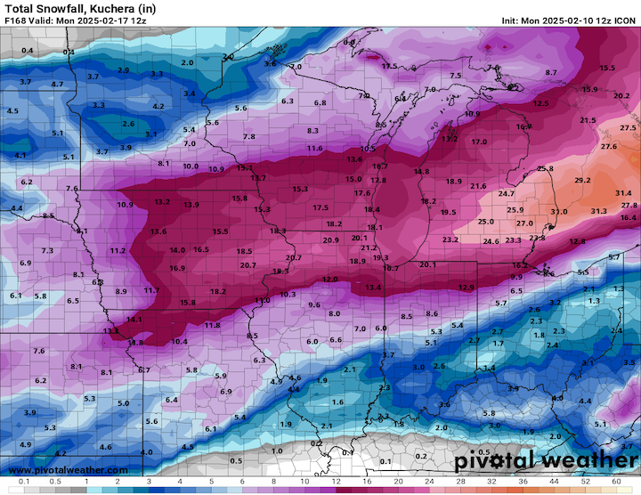
-
RGEM pretty much the same as its 6z run. Shaved a little off the northern fringes, tightened the SE fringes a bit, and back to a thumb jackpot from the 0z run. 6z EPS was essentially the same, but cut back on total QPF a bit in N IL. Chicago still 0.50"-ish, but farther southwest there was a bit of a decrease.
-
I would agree. 18 hours out from the storm, the NAM will probably have a run where it takes it off the Delaware coast. Well maybe not, but you get my drift.
-
NAM is a freight train. 12z gets a little light snow up to MSP with this run. I've got like 15 miles left and its lights out. 12z 3km NAM not nearly as amped though.
-
Yeah, that's good. I didn't see it when I made that post. Was referring to the GFS, RGEM, etc. Though I guess I also kinda lied because looking at the 6z ICON and UK, they both went south/weaker. JV models though.
-
Winter 2024-25 Medium/Long Range Discussion
Chicago WX replied to michsnowfreak's topic in Lakes/Ohio Valley
6z GEFS total run snowfall mean is up to 18.0" over downtown Chicago. Pretty large area of 6"+ really. Hopefully everyone gets a taste in the coming 2 weeks.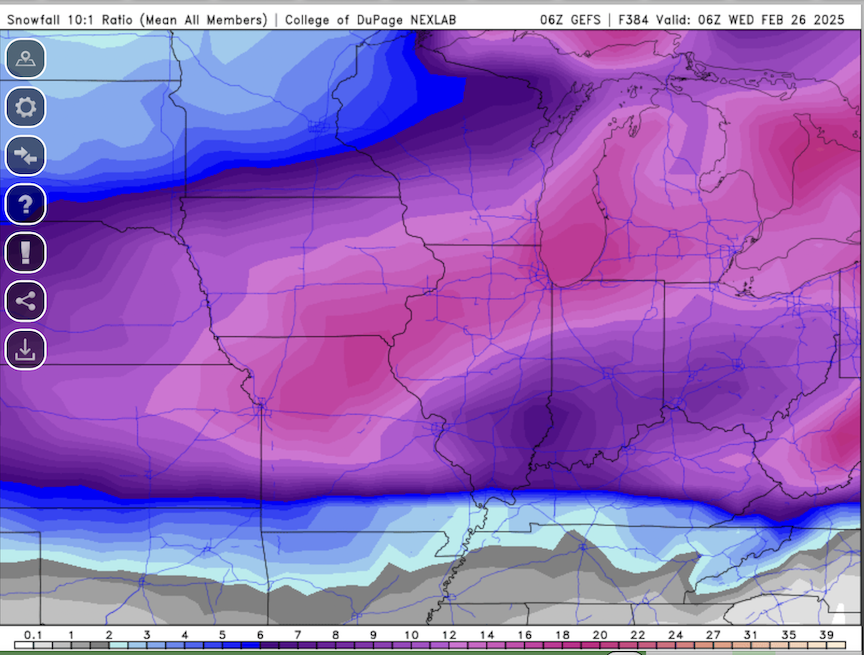
-
Pretty much everything at 6z ticked northwest. GFS closer to everyone else now. 6z NAM has the left turn blinker stuck in the on position, doing 95 mph down the Kennedy. But, nice to see an overall uptick in QPF. Just need to hold it, or get better, for 2 more days.
-
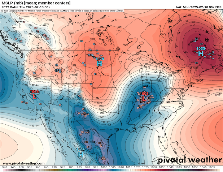
0z EPS likes Chicago.
-
Oz GGEM with a good hit. But it was definitely a step northwest, as much more of Iowa gets into the good snows.
-
GFS not backing down from whatever its doing.


