andyhb
-
Posts
20,408 -
Joined
-
Last visited
Content Type
Profiles
Blogs
Forums
American Weather
Media Demo
Store
Gallery
Everything posted by andyhb
-

Winter 2023/24 Medium/Long Range Discussion
andyhb replied to Chicago Storm's topic in Lakes/Ohio Valley
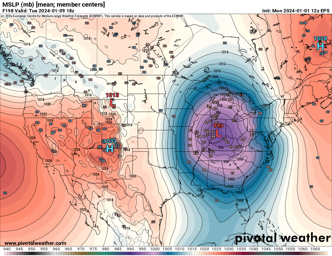
Ensemble means continue to indicate the potential for a higher end event late this weekend into early next week. Pretty expansive area of significant snowfall on the means, and a solid chunk of the members really bomb the surface low out into the 970s. Would suggest fairly widespread blizzard conditions are possible. Looks to be a potential coast to coast storm as well and should certainly help the snowpack out west. I do like how the cold air is there but not overwhelming, which would suggest less potential for the surface low to get suppressed by excess high pressure in its developmental stages.
-
Winter 2023/24 Medium/Long Range Discussion
andyhb replied to Chicago Storm's topic in Lakes/Ohio Valley
#rdy2bburied -
Winter 2023/24 Medium/Long Range Discussion
andyhb replied to Chicago Storm's topic in Lakes/Ohio Valley
Impressive EPS mean for that far out.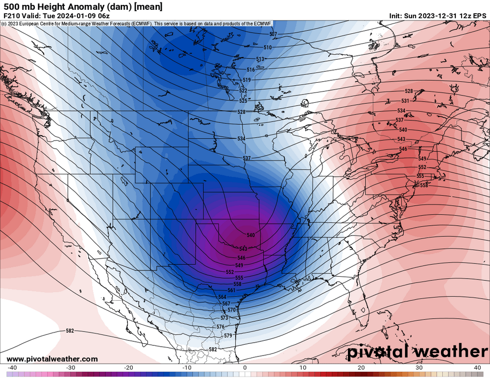
-
Winter 2023/24 Medium/Long Range Discussion
andyhb replied to Chicago Storm's topic in Lakes/Ohio Valley
That storm on the Euro/GFS/ensembles in the second week of January is a monster. A bit of a shame that moisture is cut off by the preceding system about 36-48 hours prior, but the ensembles are pretty locked it for high impact potential across a pretty large expanse of real estate. One may be concerned about the degree of suppression if all of the cold becomes involved at once, the STJ dominates, and/or the surface reflection isn’t as strong initially. -
Winter 2023/24 Medium/Long Range Discussion
andyhb replied to Chicago Storm's topic in Lakes/Ohio Valley
How has that guy not been banned yet... -
https://x.com/LydiaFielderTV/status/1733641370793812357?s=20 Multiple deaths reported from the Clarksville TN tornado earlier.
-
https://x.com/TikovonlaberWX/status/1733624586376233148?s=20 In Gallatin.
-
Supercell west of Nashville is looking prime to produce a strong tornado.
-
https://x.com/NC5_LelanStatom/status/1733584838408425710?s=20
-
Apparently the Robinson IL/Sullivan IN tornado from this event is being re-evaluated by NWS Lincoln, partly due to flooding that prevented surveys of certain portions of the track. Wonder if we get an upgrade to EF4 here.
-
10 years since 11/17/2013 today.
-
https://x.com/ClintonHaVi/status/1717062382290186357?s=20 Conditions getting very nasty via this video.
-
Acapulco does have a radar, but it is currently out of service and has been for sometime. They have had major upheaval in that city in the 21st Century.
-
That is one of the all time NHC discussions.
-
It's a Cat 5 per NHC...
-
Acapulco is in trouble from this one if it continues to outpace intensity forecasts/doesn't fall apart on approach. Current official track essentially puts the RFQ right over the bay/city. Some Pauline '97 vibes with how it parallels the coast for a bit too, which produced extreme flooding in Guerrero.
-
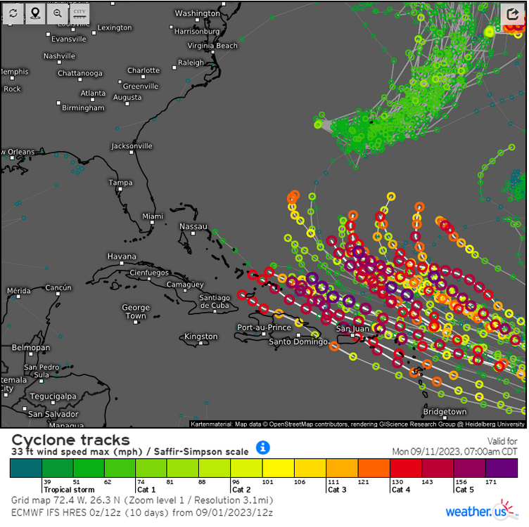
12z guidance, particularly the Euro, are not painting a pretty picture for 94L regarding the Antilles. MDR upper air pattern is amazingly favorable for it this late in the season in an El Nino year, plenty of heat content/warm SSTs to work with as well.
-
https://twitter.com/seekndstroy7809/status/1699937840262512887?s=46&t=lVM9qxUr3uVWV5VH8ESp6g This may be a first.
-
The new HAFS-A is literal weenie bait, gets down to 900 mb with 178 kt (205 mph) sustained winds in the next 36 hours. That would break the Atlantic record for wind speed by 15 mph (Allen, 1980).
-
Getting even better.
-
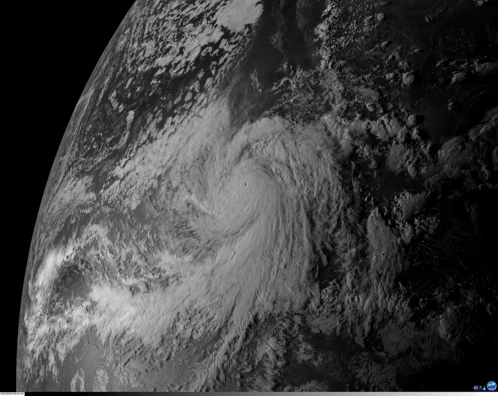
Basically a perfectly formed inner core on the latest microwave satellite imagery. This is likely going to be pushing Cat 5 in this first recon pass.
-
Hurricane Jova is a monster right now. Current advisory has it at 130 mph/953 mb, but I guarantee it is considerably stronger.
-
Potential Northeast storms are so annoying to track, most notably due to the constant influx of unnecessary 1938 comparisons that are bound to arise.
-
A lot of very strong members with potential Lee. Looks like a potential long tracker/high ACE producer at minimum. Not an auto-fish look either.
-
00z NAM 3 km is absolutely ridiculous rainfall wise and particularly in the orographic enhancement areas of the San Bernardino and San Jacinto mountains. Those totals (10-20” in less than 3 days) would be catastrophic for the surrounding runoff areas.