andyhb
-
Posts
20,454 -
Joined
-
Last visited
Content Type
Profiles
Blogs
Forums
American Weather
Media Demo
Store
Gallery
Everything posted by andyhb
-
Going to be piling on ACE quite quickly here with both Kirk (already likely a mid-higher end Cat 4) and Leslie (forecast to become a major). I've also seen some rather concerning intensity estimates from the 18z intensity guidance with the remnants of TD 11 that will become the Gulf low that has been discussed in here, notably from the HAFS. Going to be dependent on whether it can organize its core or not.
-
That 130 mph/954 mb estimate is probably underdone. Looks closer to the border between Cat4/Cat 5 vs Cat 3/Cat 4 right now on IR.
-
It appears the death toll has surpassed 200 with additional fatalities being recorded from GA. The death toll in NC has also risen above 100.
-
Death toll has reached 200 with additional fatalities being reported from GA.
-
Most of the deaths in GA and SC were from wind, mind you. Helene was really bad wind wise further inland, just not right at the landfall point.
-
Now 57 dead in Buncombe Co. NC (Asheville and vicinity) alone.
-
Now 57 dead in Buncombe Co. alone via local sheriff.
-
Without the deep moisture feed from Helene's circulation, the PRE wouldn't have been as crippling in its own right.
-
Yes, but you're probably reading too much nonsense on Twitter.
-
Perhaps the best benchmark for specifically W NC here is comparing to the Great Flood of 1916, which was the previous flood of record for the area and was caused by back-to-back hurricanes and their inland rainfall. The death toll from that was approximately 80 via most sources I can find. Chatter I've seen from local news outlets echoing first responders indicate this may significantly exceed that. I don't see 1000 deaths, but I could easily see 200-300 overall, which would make it the deadliest tropical cyclone in the United States aside from Katrina in decades. It already is deadlier in SC than Hugo and is the deadliest in NC likely since the mid-1800s. There are not enough superlatives to describe this event.
-
WRAL reporting 35 dead in Buncombe Co. alone.
-
35 dead in Buncombe Co. alone per WRAL.
-
Have seen some EMA chatter about this being comparable to Katrina's impact in LA/MS for E TN and W NC in terms of the extent of the destruction and infrastructure disruption. Certainly comparable to Agnes and Camille at the very least in terms of inland impacts.
-
This flooding in W NC and E TN is just about as bad as it gets. Like Camille was for central VA or Agnes was for central PA.
-
Probably the strongest message I have ever seen from Brad Panovich.
-
To be fair, the Tampa/St. Petersburg area is flooding badly right now. This is going to be a very costly storm for that area, even though it didn't hit them directly.
-
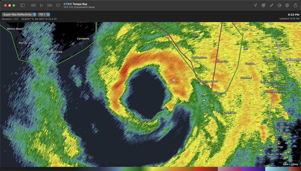
Extreme velocities showing up from the dealiased TLH radar data right now. 175-180+ mph in the northern eyewall.
-
Might be the best the eyewall has looked from the Tampa radar in terms of closure.
-
Tops to over 60k feet.
-
Extreme wind warning issued for the landfall location and northward to the GA border.
-
I mean a difference of 1.6 mb when it comes to strengthening is notable.
-
Huh? 2/3 of the eyewall is enveloped in some really intense convection right now. That's still going to drop the pressure even if one quad is a bit ragged.
-
Potential aborted recon mission here. This does not happen often at all from a TC itself.
-
We are talking about Agnes in PA level flooding here.
-
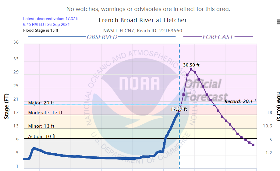
The French Broad River (river that flows through Asheville NC) is forecast to crest more than 10 feet above the previous record at Fletcher, which is in the southern part of the metro.