1234snow
-
Posts
1,833 -
Joined
-
Last visited
Content Type
Profiles
Blogs
Forums
American Weather
Media Demo
Store
Gallery
Everything posted by 1234snow
-
Tornado warned storm east of Lebanon/Nashville is moving along I-40 with possibly a couplet developing:
-
Etowah storm report of 1.75” hail (golf ball). If in the path northeast of there I would certainly cover vehicles if possible. Appears Tellico Plains will get squeezed in between the 2 cells. Also a warned storm on the plateau.
-
Closeup:
-
Have our first severe warned storm with up to 1” hail working into Etowah and up the southern portions of the Valley.
-

TN valley heavy rain/flooding week of whenever
1234snow replied to janetjanet998's topic in Tennessee Valley
0z HI-RES NAM is wanting to move the line into the mountains by morning. -
TN valley heavy rain/flooding week of whenever
1234snow replied to janetjanet998's topic in Tennessee Valley
0z 12km NAM: -
TN valley heavy rain/flooding week of whenever
1234snow replied to janetjanet998's topic in Tennessee Valley
The line appears to be making good progress eastward. I guess time till tell where it may get hung up at. -
TN valley heavy rain/flooding week of whenever
1234snow replied to janetjanet998's topic in Tennessee Valley
Really concerned about the Plateau counties into SE KY tonight and into the morning. If the 18z HI-RES NAM is to be believed 4-6” of rain will fall by tomorrow afternoon. 23z HRRR shifts the axis of the heavy rain of 4-5” from over Chattanooga up the spine of the mountains. Anyway you slice it someone in our forum area will have some very dangerous flash flooding. -
TN valley heavy rain/flooding week of whenever
1234snow replied to janetjanet998's topic in Tennessee Valley
Flash Flood Emergency issued for Knox County. -
TN valley heavy rain/flooding week of whenever
1234snow replied to janetjanet998's topic in Tennessee Valley
Camp Creek gust of 123mph was ruled erroneous after quality control. Gust was revised to 81mph. -
TN valley heavy rain/flooding week of whenever
1234snow replied to janetjanet998's topic in Tennessee Valley
All local tv Mets have used the 123mph measurement on social media this morning. [emoji2960] -
TN valley heavy rain/flooding week of whenever
1234snow replied to janetjanet998's topic in Tennessee Valley
-
TN valley heavy rain/flooding week of whenever
1234snow replied to janetjanet998's topic in Tennessee Valley
This morning’s rains have already brought .75 to over an inch for much of SWVA. -
Kingsport needs to watch out for hail over the next hour or so. Already half inch hail reported. Also some idiot lit a brush fire about 10 minutes ago. Wind is howling.
-
SPC outlook today. Large hail and damaging winds the threat this evening across NETN/SWVA.
-
Welcome! We are glad to have more posters. Feel free to ask anything. No question is a stupid one here. I'm still learning a lot. Weather is a very humbling hobby. We have some very good people here so you should pick up the learning curve quick. It was hard to weed through all of the talk in the southeast forum before we seceded from them. Your right the SE forum was basically all NC. There might of been 1 out of 20 posts about the TN valley and Alabama/MS. But we started from the bottom and now we're here (lol). You couldn't of picked a better time to join.
-
Stole these from the Southeast Forum.
-
Also here's the Mesoanalysis page from SPC. I saw the link to the SPC Main page but I thought it would be good to include this one. http://www.spc.noaa.gov/exper/mesoanalysis/new/viewsector.php?sector=17 Weather Glossary that has definitions for just about all weather terms: http://www.weatherzone.com.au/help/glossary.jsp
-
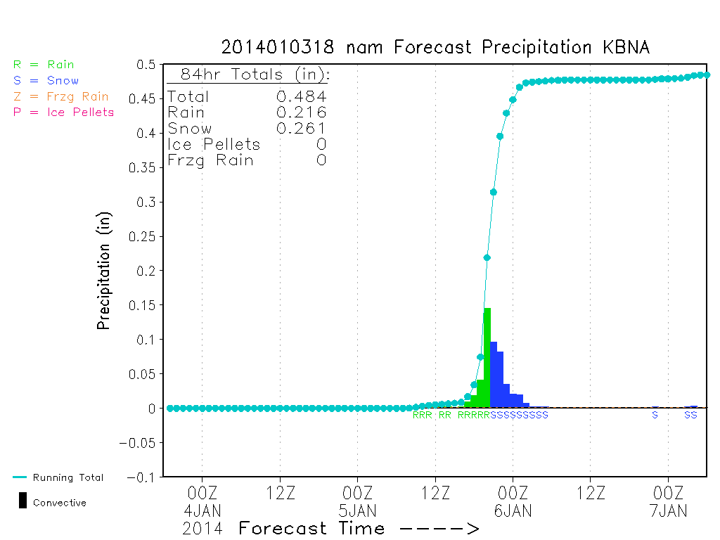
Here are a few websites I look at that I didn't see on the list. Meteogram Generator: http://www.meteor.iastate.edu/~ckarsten/bufkit/image_loader.phtml Cool Wx (I use this site to look at precip type and accumulation for NAM, RUC, and GFS, also has a lot of other stuff like mesoscale analysis stuff - temp, dewpoint, etc.) Only problem is that they only have two sites for TN: BNA and MEM. Example from 18z NAM for BNA: http://coolwx.com/ This next website is a another TN weather forum but it also has some nice maps on the side for the WRF Simulated Radar, real-time radar, temp, jet stream, satellites, and many many another things. I look at this website a lot and I know some of you have been on it before and are members. http://www.tnweatherspot.com/ Winter Prediction Center's page(WPC) has probability maps for snow, freezing rain and other stuff. http://www.hpc.ncep.noaa.gov/wwd/winter_wx.shtml
-
Historic Tennessee Valley Cold, Snow, and Ice Events
1234snow replied to Carvers Gap's topic in Tennessee Valley
Does anybody remember this little event on Morristown's page?: Local Weather History for December 31st...... Local Weather History For December 31st... Winter storm dumped 2-5" snow over the area in 1997. 4-8’ fell in the mountains. -
Thanks Mr Bob, Stovepipe, Carvers Gap, tnweathernut and everyone else this has been a long time in the making!