

cyclone77
-
Posts
18,631 -
Joined
-
Last visited
Content Type
Profiles
Blogs
Forums
American Weather
Media Demo
Store
Gallery
Everything posted by cyclone77
-
Vis nicely shows the bare ground along/south of route 30. Should be a nice FU sandwich along I-80 showing up on vis in a few days with the new snow field to the south. Bout ready to move on to spring..
-

1/24-1/25 Major Winter Storm - S. IL, IN, and OH
cyclone77 replied to A-L-E-K's topic in Lakes/Ohio Valley
-
Winter 2025-26 Medium/Long Range Discussion
cyclone77 replied to michsnowfreak's topic in Lakes/Ohio Valley
Yeah. Looks like we'll continue to remain on the sidelines until the 2nd week of Feb. Have had bare ground here now for almost a month other than a few fleeting DABz. -
1/24-1/25 Major Winter Storm - S. IL, IN, and OH
cyclone77 replied to A-L-E-K's topic in Lakes/Ohio Valley
Remember them negative jobs, with those giant northward moving dry slots? -
1/24-1/25 Major Winter Storm - S. IL, IN, and OH
cyclone77 replied to A-L-E-K's topic in Lakes/Ohio Valley
Got a sneak peek of the new GFS with the included recon data.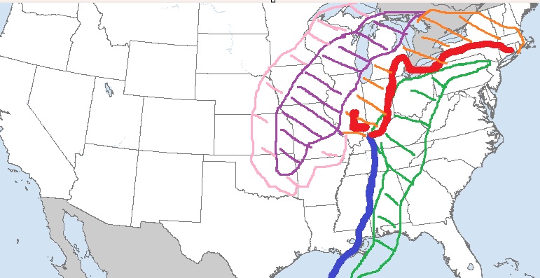
- 935 replies
-
- 23
-

-

-

-
Winter 2025-26 Medium/Long Range Discussion
cyclone77 replied to michsnowfreak's topic in Lakes/Ohio Valley
zzzzzz -
Winter 2025-26 Short Range Discussion
cyclone77 replied to SchaumburgStormer's topic in Lakes/Ohio Valley
All we have on the ground here is some leftover dead leaves from the fall to blow around. No blowing snow to worry about here for the foreseeable future. -
Winter 2025-26 Short Range Discussion
cyclone77 replied to SchaumburgStormer's topic in Lakes/Ohio Valley
Picked up a T here. -
Winter 2025-26 Medium/Long Range Discussion
cyclone77 replied to michsnowfreak's topic in Lakes/Ohio Valley
Will be a complete whiff for this area. Southern and eastern sub may get a taste. -
Winter 2025-26 Short Range Discussion
cyclone77 replied to SchaumburgStormer's topic in Lakes/Ohio Valley
Getting a few flakes down to the surface now here beneath this 20DBZ band. -
Winter 2025-26 Medium/Long Range Discussion
cyclone77 replied to michsnowfreak's topic in Lakes/Ohio Valley
Gonna have to take a shot of jagermeister before opening the gas bill in about a month or so. -
Winter 2025-26 Medium/Long Range Discussion
cyclone77 replied to michsnowfreak's topic in Lakes/Ohio Valley
Hope nobody plans on using FedEx for several days. Memphis gonna get shellacked. -
-2 this morning, but felt almost mild with the calm winds compared to yesterday's 35mph winds.
-
Winter 2025-26 Medium/Long Range Discussion
cyclone77 replied to michsnowfreak's topic in Lakes/Ohio Valley
Hopefully we'll have something to track in about 10-15 days. -
If trends continue should be some awesome pics/video coming out of that swath. Arklatex area/southern AR look like they could be ground zero where the ice band sort of pivots.
-
Don't like extreme cold without snow cover. Frost goes deeeeep.
-
Pete Carroll's available.
-
Winter 2025-26 Short Range Discussion
cyclone77 replied to SchaumburgStormer's topic in Lakes/Ohio Valley
Mostly miss north of I-80 in this area. I'll take the usual <1". -
Nice snow squall moving through. Vis down to about a half mile, and 45mph winds hitting as well.
-
Winter 2025-26 Short Range Discussion
cyclone77 replied to SchaumburgStormer's topic in Lakes/Ohio Valley
No one's winning in Seattle anyway. Pats/Seahags super bowl incominig. -
Winter 2025-26 Medium/Long Range Discussion
cyclone77 replied to michsnowfreak's topic in Lakes/Ohio Valley
CAD would be correct if it stood for cold and dusters. -
Picked up 0.3" yesterday. Should pick up another 0.1-0.3" today, although the majority of today's activity will once again mostly miss northeast.
-
Winter 2025-26 Medium/Long Range Discussion
cyclone77 replied to michsnowfreak's topic in Lakes/Ohio Valley
Nope, just more of the same garbage as far as the eye can see. Eastern lakes and LES peeps will continue to be placated though. Tolerable pattern for them. -
Winter 2025-26 Medium/Long Range Discussion
cyclone77 replied to michsnowfreak's topic in Lakes/Ohio Valley
zzzzzz -
Hasn't snowed here since very early this morning, as we've been sort of in between all of the rotating bands. Should finally get into another period of light snow early tomorrow afternoon. Hopefully we can scrounge up another turd dusting from that.


