cyclone77
-
Posts
18,903 -
Joined
-
Last visited
Content Type
Profiles
Blogs
Forums
American Weather
Media Demo
Store
Gallery
Everything posted by cyclone77
-
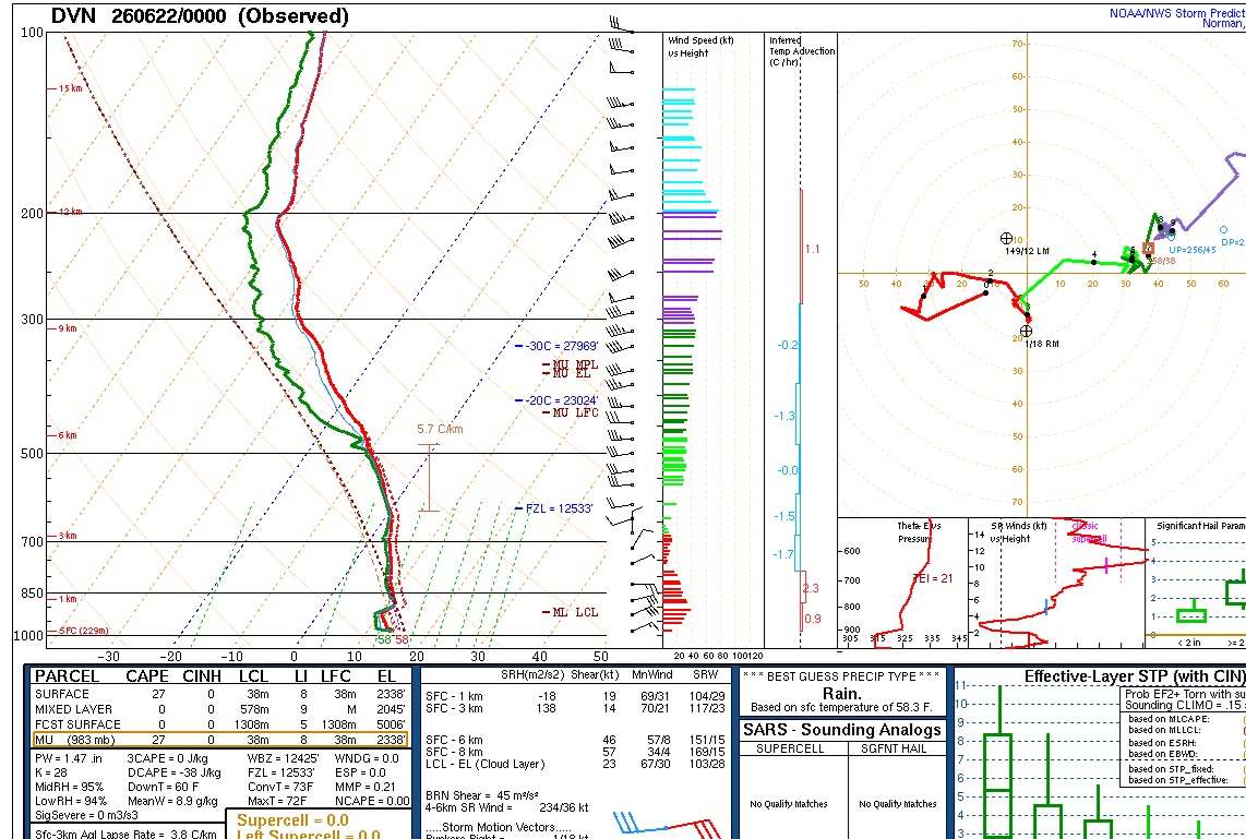
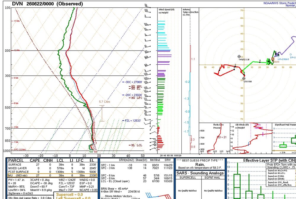
Ultra saturated sounding from DVN earlier this evening. Explains why even the drizzle was heavy earlier.
-
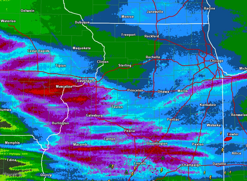
2.17" so far. Nice soaker. EDIT: 2.37" now as it winds down. Seemed a lot like tropical remnants today. Pretty unusual to get this much stratiform rain in late June with zero thunder. The past hour or so we had heavy drizzle coming down in sheets with the gusty ne winds. Gave us an extra couple of tenths.
-
Nice high efficiency soaker. Just blew by the 1 inch mark and it's pouring very nicely.
-
Looks like an inch of rain is possible tomorrow for this area. 2-3" rains possible south of I-80.
-
And we still have a lot of 1-scan wonders from DVN to pad the total with during derecho season coming up.
-
Some beefy qpf showing up on some guidance. Euro has been depositing a swath of 2-4" for several runs. Might need to have the grilling get togethers Sat this year. Sunday might be a day better spent on the couch watching the US open lol.
-
lol northwest IL.
-
Finished with 0.78". June up to 5" on the nose now. Only notable thing from this event was the 50mph winds that lasted about 45 minutes on the backside of the anvil rains.
-
Think it's some process that's enhancing the surface flow. Bringing some of the higher velocity winds down to the surface.
-
Yeah the back side winds have been impressive.
-
Yeah it's only in the mid 50s here with a driving rain. Big change later though, should see dews near 70 in about 7-8hrs. 0.59" rain so far.
-
There could be a secondary area of interest up closer to the low pressure later today over northeast IA/southwest WI and maybe far northwest IL. Would be less of a stronger tor threat, but definitely something to watch.
-
Don't think many anticipated the wind aspect to be as impressive as it was with the morning MCS out in Iowa. The areas hit hardest had dews in the upper 40s/lower 50s shortly before being hit by it. Very impressive. Gonna get sort of some comma head action here, but no severe worries. Think our severe threat is cooked here, as redevelopment later today will be south/southeast of the area.
-
Just call in sick. No one will suspect a thing.
-
Biggest threat here tomorrow will be from hail. Luckily the real tornado action will avoid this area per usual.
-
Kind of wondering if this setup is going to over-convect. Several models are showing a line of supercells. May be too much storm competition for a widespread tornado setup. Gonna be interesting to see how this plays out.
-
Main action likely to miss east and especially south of here. Should get a nice non severe MCS in the morning though.
-
49 here this morning.
-
Yep. Might as well head towards Pontiac to Kankakee and camp out there until the event lol.
-
Multiple models are showing a large MCS traversing Iowa again the morning of the event. Will be interesting to see how the evolution of that affects the development later in the day. Very impressed by the synoptics of this. Powerful upper jet knifing in with very impressive shear profiles over a wide area on the nose of that.
-
0.17" overnight. Nice swath of 1-1.5" about 15 miles south of here. Up to 4.20" for June.
-
1.41" rain here today, which bumps us to 4.03 for June.
-
Just had a legit meso pass right over about 10 mins ago. Really thought it might plant right there. Serious rippage with nice downward motion on the back side. Couplet is now over Lyndon. Thing is hauling ass northeast.
-
First round quickly converted over to anvil rain on approach. Let's see what round 2 does.