cyclone77
-
Posts
18,651 -
Joined
-
Last visited
Content Type
Profiles
Blogs
Forums
American Weather
Media Demo
Store
Gallery
Everything posted by cyclone77
-
Not in our sub, but pretty impressive conditions down in western TX/southeast NM. Temps near 80, with dews in the -10s producing humidity values of 2% in several locations. Also 60-70mph winds whipping up a nice dust storm.
-

Winter 2024-25 Medium/Long Range Discussion
cyclone77 replied to michsnowfreak's topic in Lakes/Ohio Valley
So March and probably April is doing what it's supposed to do. Why can't we get Dec-Feb to do the same? lol -
Looking like another day with 50+mph winds on Wednesday behind the departing storm system.
-
Winter 2024-25 Medium/Long Range Discussion
cyclone77 replied to michsnowfreak's topic in Lakes/Ohio Valley
Almost identical actually( MLI & DVN), both are 22 miles away as the crow flies. Temp wise this area is more similar to MLI as both here and at MLI are in the Rock River valley. -
The late afternoon sky had a brownish haze from all the lofted dirt from the high winds out west. Had a nice period of 50-55mph winds around these parts as well. Surprised to see a few trees species have swollen buds from the past few days of 50s and 60s. Guess the sap must already be flowing upward despite the bitter cold last week.
-
Winter 2024-25 Medium/Long Range Discussion
cyclone77 replied to michsnowfreak's topic in Lakes/Ohio Valley
Likely overdoing everything per usual. Cut the excitement by about 30-50% and there's the final solution if seasonal trends persist. Early guess for here is a nice soaker followed by a few wet flakes. -
MLI now 2 feet of snow below normal. Futility record getting more and more probable.
-
Winter 2024-25 Medium/Long Range Discussion
cyclone77 replied to michsnowfreak's topic in Lakes/Ohio Valley
Looking forward to the first thunder of the year next Tuesday. -
Was hoping that would make it here but it's crapping the bed on approach. First Iowa sloppy seconds of the year, check.
-
They did, MLI hit 61 today. Felt great!
-
Made it to 50 here, MLI hit 51. DVN has 52 in the point for tomorrow and Tue. Will bust low pretty badly.
-
Temps overachieving again as the last of the snow melts away. Should make a run at 50 today, and it now looks like 60 is attainable both tomorrow and Tuesday. Probably in the 60s on Friday. So long POS winter.
-
Temps overachieved here today, made it to 35. 50s Monday and maybe pushing 60 Tue and Wed.
-
Today's -4 here was our 7th subzero day of the month. Had 6 days in January, so 13 total for the season. Coldest was -14 back in January.
-
@JoMo
-
One more below zero day tomorrow, then sayonara to all this arctic BS. Looking forward to the 50s next week. Zero snow in sight the next 10 days.
-
High clouds never cleared the area and cut into max cooling potential a bit. Still managed to get down to -12 so far. Looking like a nice streak of 50s starting Monday next week. May even make a run at 60 Wednesday. Should take care of this 2-3" snowpack very quickly. Thinking we have a good chance at overachieving temps as we head into March with such a widespread dry landscape. Hopefully 70s are less than a month away.
-
Temps overachieved here this morning with -7. Good chance we make a run at -15 tonight for the coldest night of the season. Coldest so far was -14 back on Jan 21st.
-
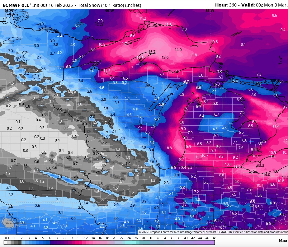
Looking basically snowless going forward into early March from this area northwestward. Mason City is doing even worse than MLI (which has 6.7" currently) with only 3.4" for the season. That's about 26" below normal. I couldn't find what the all-time least snowy season was for Mason City on the Des Moines WFO site, so not sure what they'll need to break that record. It's all going to come down to whether or not we can sneak through March/early April without too many nickel and dimers. Now that we've made it this far I want to break that futility record, but if a major snowstorm were to end that possibility I'd be okay with that I guess.

-
Fall/Winter '24 Banter and Complaints Go Here
cyclone77 replied to IWXwx's topic in Lakes/Ohio Valley
I too am ready for Spring and thunderstorms. -
Getting some bursts of mood flakes from time to time, which is nice to see. There is about 3" of fairly fresh powder on the ground, so actually looks like deep winter out there for the first time all winter. Should be just enough snow cover to maximize the chill in coming days.
-
Nailed it
-
Fall/Winter '24 Banter and Complaints Go Here
cyclone77 replied to IWXwx's topic in Lakes/Ohio Valley
Yeah the tracking was pretty fun, but overall it was kinda meh. Still a lot of red numbers on this map unfortunately, even after the busier pattern. EDIT: Also looks like it's been a bummer winter up where Bo is. Haven't seen him around here for awhile, guessing he quit the site again?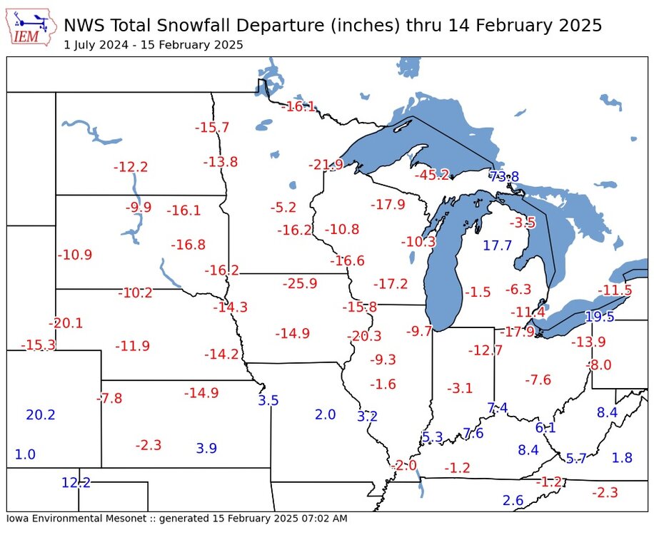
-
Was pretty legit out there for awhile with that WAA bump. Picked up a quick inch with some nice near-blizzard action out in the open country. As expected tomorrow looking like a strung out POS, so additional snowfall prob <1" for this area.
-
-6 here this morning, but have already bumped back up to 1 above as WAA has commenced.