LVblizzard
-
Posts
4,900 -
Joined
-
Last visited
Content Type
Profiles
Blogs
Forums
American Weather
Media Demo
Store
Gallery
Everything posted by LVblizzard
-
The rug pull was much harsher with that one. It went from a big storm to almost nothing in just a day or two. At least with this one we still have a decent chance at a light to moderate event as the phase happens.
-
If all of JB's predictions came true everyone in the northeast would double or triple their yearly snow totals.
-
E PA/NJ/DE Winter 2025-26 Obs/Discussion
LVblizzard replied to LVblizzard's topic in Philadelphia Region
Add the Euro to the “nuisance event” category. It just doesn’t want to budge. -
Not really. We have the ICON showing a nuisance event at best, the UKMET gives nobody anything more than flurries, and the NAM was going to end up pretty weak too. The models are split close to 50/50 right now on the outcome.
-
Feb 22nd/23rd "There's no way..." Storm Thread
LVblizzard replied to Maestrobjwa's topic in Mid Atlantic
If you’re comparing it to 12z it’s better. But 18z was overall better than the current run. -
Feb 22nd/23rd "There's no way..." Storm Thread
LVblizzard replied to Maestrobjwa's topic in Mid Atlantic
It started off better but that piece of energy over the great lakes ended up farther south which doesn’t allow for the amplification we need to have this thing climb the coast. -
E PA/NJ/DE Winter 2025-26 Obs/Discussion
LVblizzard replied to LVblizzard's topic in Philadelphia Region
Tonight’s model scorecard so far: Big storm: GFS Plowable event: Canadian Nuisance event: ICON Miss/flurries: UKMET, probably the NAM -
E PA/NJ/DE Winter 2025-26 Obs/Discussion
LVblizzard replied to LVblizzard's topic in Philadelphia Region
Well the GFS certainly isn't backing down. 1-2 feet south of Philly, 6-12" up to the Lehigh Valley. Not really buying it right now but it's nice to at least have a shred of hope remaining. -
E PA/NJ/DE Winter 2025-26 Obs/Discussion
LVblizzard replied to LVblizzard's topic in Philadelphia Region
I think our best bet is with the inverted trough feature that most models are picking up on. The ICON showed a region-wide 1-3” from it. We’ll see what the other models do. -
E PA/NJ/DE Winter 2025-26 Obs/Discussion
LVblizzard replied to LVblizzard's topic in Philadelphia Region
Sun angle is much higher than in December which makes it feel warmer and more like spring. That’s my guess anyway. -
E PA/NJ/DE Winter 2025-26 Obs/Discussion
LVblizzard replied to LVblizzard's topic in Philadelphia Region
It’s crazy how so many people are always surprised when it snows well into March. Yes it’s not meteorological winter anymore, but historically it’s a snowier month than December. -
E PA/NJ/DE Winter 2025-26 Obs/Discussion
LVblizzard replied to LVblizzard's topic in Philadelphia Region
18z Euro doesn’t give us what we want but it improved quite a bit over 12z at both H5 and the surface. Tonight’s 0z runs will be very interesting. -
E PA/NJ/DE Winter 2025-26 Obs/Discussion
LVblizzard replied to LVblizzard's topic in Philadelphia Region
18z GFS got better too. Only 18z model that's a dud so far is the NAM, and it still improved at H5. Interested to see what the Euro does. I don't expect it to be a hit, but I'd welcome any improvements. -
Are we all just going to ignore the RGEM? End of the run looks decent and it would probably lead to something pretty juicy.
-
The NAM did improve slightly at H5 but the surface is still complete dogshit.
-
E PA/NJ/DE Winter 2025-26 Obs/Discussion
LVblizzard replied to LVblizzard's topic in Philadelphia Region
Euro misses with the IVT too. Worst case scenario for the subforum. -
E PA/NJ/DE Winter 2025-26 Obs/Discussion
LVblizzard replied to LVblizzard's topic in Philadelphia Region
Well now the regular Euro is out and it is indeed trash. Not sure about any precip from the IVT since those maps aren’t out yet, but the coastal misses by hundreds of miles. -
E PA/NJ/DE Winter 2025-26 Obs/Discussion
LVblizzard replied to LVblizzard's topic in Philadelphia Region
We also need Friday’s storm to get out of the way to allow heights to rise on the east coast. Otherwise even a very amplified system is staying mostly south of PA. -
E PA/NJ/DE Winter 2025-26 Obs/Discussion
LVblizzard replied to LVblizzard's topic in Philadelphia Region
18z GFS reminds me a lot of Boxing Day 2010. A storm that was so painfully close in eastern PA. -
E PA/NJ/DE Winter 2025-26 Obs/Discussion
LVblizzard replied to LVblizzard's topic in Philadelphia Region
We’re not in a bad spot at the moment. Would prefer if the trends at 18z don’t continue at 0z though. -
Not surprising with the convoluted upper air setup in Canada. Nothing will be nailed down until tomorrow night or early Thursday.
-
ICON isn’t like 12z at all but it shouldn’t be a nothingburger like the Euro was.
-
E PA/NJ/DE Winter 2025-26 Obs/Discussion
LVblizzard replied to LVblizzard's topic in Philadelphia Region
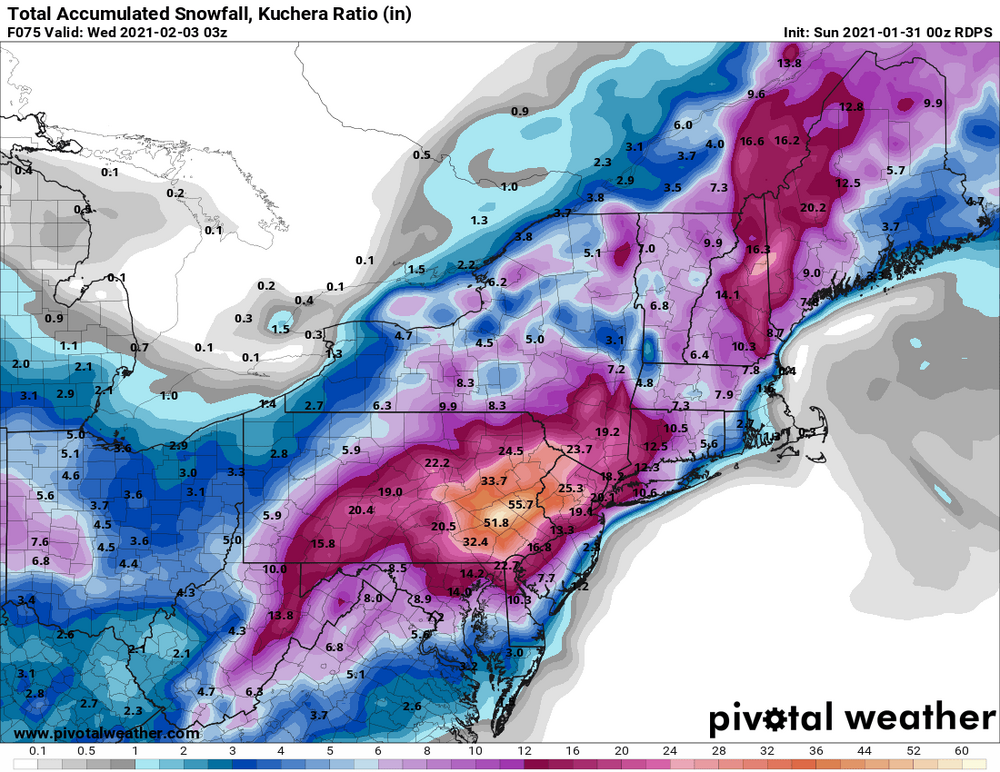
That storm started on a Sunday afternoon and didn’t fully end till Wednesday morning. It was like 6 inches on Sunday, 15 inches on Monday, and the rest on Tuesday and Wednesday. I think the total at ABE airport was about 2 feet. One of our greatest storms of all time. -
E PA/NJ/DE Winter 2025-26 Obs/Discussion
LVblizzard replied to LVblizzard's topic in Philadelphia Region
Still have the RGEM run saved where it printed out 4-5 feet for the Lehigh Valley.