

nwohweather
-
Posts
3,817 -
Joined
-
Last visited
Content Type
Profiles
Blogs
Forums
American Weather
Media Demo
Store
Gallery
Everything posted by nwohweather
-
Sucks? Feels so nice to drive with the windows down again
-

Winter 2024-25 Medium/Long Range Discussion
nwohweather replied to michsnowfreak's topic in Lakes/Ohio Valley
It’s beyond needed. One of the coldest winters here in quite some time, a thaw is okay by me -
Joplin Tornado (5/22/2011) Netflix Movie
nwohweather replied to KokomoWX's topic in Lakes/Ohio Valley
I would argue this was the worst tornado in American history. A mile wide EF5 surging thru the heart of a 50,000 person city? 158 lives lost with modern forecasting technology and the communications system we have today is insane. I cannot imagine if this were to have happened in the 1940s what it would have done. -
That stretch is what causes so much of the bellyaching we see on here. Since 2005 Toledo, OH has seen the #1, 3 & 5th snowiest Januaries and the #1, 2, 4, 5, 6 & 9th snowiest Februaries on record. If you like snow, you’ve had an all time run
-
Bingo. It didn’t help that not only was there that powerhouse line through the south, but strong convection along the Ohio River holding down moisture on the back end of this system quite a bit
-
Not sure what IWX and CLE are doing here. Absolutely nothing up and you’ve got good model consistency on at least 3-6” if not 4-8”. Not ideal, at least throw up an advisory
-
What a turn of events. Congrats to the snow lovers in NW Ohio and SE Michigan if this holds. Looks like Detroit beats Chicago in yet another thing
-
Looks like 4-8” now for Toledo metro tomorrow
-
As so they should. Verbatim were looking at 3-6” for NW Ohio early Sunday morning on the Euro and GFS
-
Well said This is why I prefer severe weather Verbatim the GFS & Euro show the Toledo metro getting absolutely slammed early Sunday morning. Would be the heaviest snow I've seen in years
-
Yeah this is disappointing to see how things are struggling to fill in. It doesn’t help there’s a nice tornado outbreak to the south
-
I would feel pretty confident in Northern Ohio for this one. Looks like a solid 6-12” in that main swath
-
Can we rely on it though? It still along the cutoff line has a wildly different split. I’m going 2-4” north of US 24 and 1-2” south of it. Might as well just label it as cement for the final accumulations
-
I'll take it all day Feeling more and more confident in a 3-6" for the Toledo metro as this goes on. To your point, wagons south and the GFS winning is an odd feeling
-
Nor should it be. You have the GFS with a weaker system sliding east of Cleveland giving huge snows west and NW of the Maumee River while the Euro & NAM take the SLP center directly over Toledo. That’s still quite a bit of uncertainty for 2.5 days out. I would lean towards the NAM & Euro at this time
-
How was it at your house? I’d say we got about 2” of mostly snow here
-
Lapse rates are pretty solid. Looks like another round of freezing thunderstorms for the area
-
I’d be pretty optimistic if I were in Detroit/Toledo/Ft Wayne for this one. Very concerned about that low placement to the east, could be a significant icing event on deck here
-
Won’t be a fun day with all of that sleet and ice. Can’t come at a worse time either
-
Winter 2024-25 Medium/Long Range Discussion
nwohweather replied to michsnowfreak's topic in Lakes/Ohio Valley
It definitely looks like the groundhog was right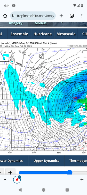
-
Extremely impressive. And cloud tops are exceeding 30,000 feet.
-
Pretty confident in Toledo getting .2" of freezing rain at this time
-
Still a complete crush job on the 12z Euro for NW Ohio while it's peanuts on the NAM. I think CLE likely goes ahead with a Winter Storm or Ice Storm Warning tomorrow morning if we can get some model consensus, that east wind off the icy lake should help metro Toledo combat surface temp increases coming from both the warm surge of air aloft along with the latent heat release that comes with freezing rain
-
Agreed but flat shortwave should hold back the warm surge enough to allow for hours of over running though
-
Looks like a breezy but sunny week ahead for us. I could definitely go for a few days in the 40s, cabin fever is starting to hit pretty hard


