CoraopolisWx
-
Posts
2,960 -
Joined
-
Last visited
About CoraopolisWx

Recent Profile Visitors


-

Pittsburgh/Western PA WINTER ‘25/‘26
CoraopolisWx replied to Burghblizz's topic in Upstate New York/Pennsylvania
IMHO, the biggest threat locally will be potential landslides over the next few weeks. Winter soil combined with above average rainfall and mild temps could be a problem. -
Pittsburgh/Western PA WINTER ‘25/‘26
CoraopolisWx replied to Burghblizz's topic in Upstate New York/Pennsylvania
Snow board measurements are usually more than in ground post storm measurements. -
Pittsburgh/Western PA WINTER ‘25/‘26
CoraopolisWx replied to Burghblizz's topic in Upstate New York/Pennsylvania
-
Pittsburgh/Western PA WINTER ‘25/‘26
CoraopolisWx replied to Burghblizz's topic in Upstate New York/Pennsylvania
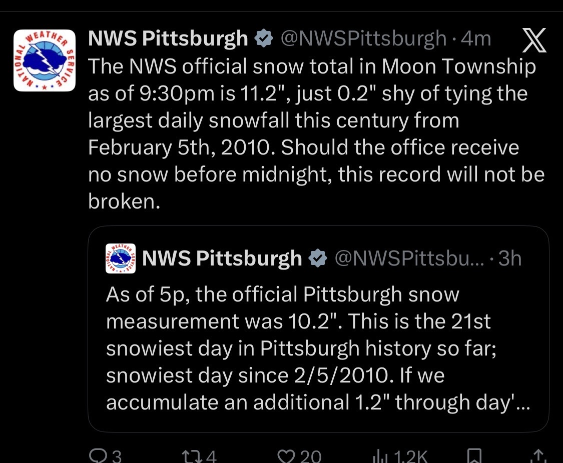
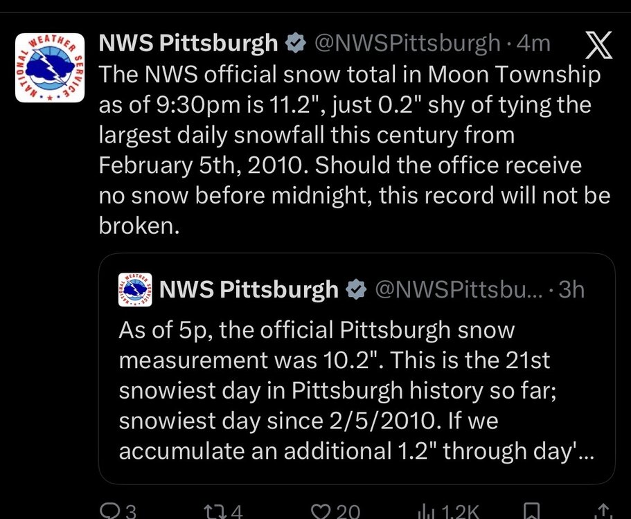
Was out earlier around 130 here in Mt Lebanon, and measured 7.5-8” in a few open areas. So with that back side energy coming through Indiana, an official NWS storm total of at least 12” looks doable. -
Pittsburgh/Western PA WINTER ‘25/‘26
CoraopolisWx replied to Burghblizz's topic in Upstate New York/Pennsylvania
30-35 dBZ returns coming out of southern Ohio and W.V. Probably 1.5-2.0” rates for some folks later on. -
Pittsburgh/Western PA WINTER ‘25/‘26
CoraopolisWx replied to Burghblizz's topic in Upstate New York/Pennsylvania
Eastern Wx. -
Pittsburgh/Western PA WINTER ‘25/‘26
CoraopolisWx replied to Burghblizz's topic in Upstate New York/Pennsylvania
18z Guidance is fully in agreement on a high end warning event. Kickoff/nowcast in about 6hrs. -
Pittsburgh/Western PA WINTER ‘25/‘26
CoraopolisWx replied to Burghblizz's topic in Upstate New York/Pennsylvania
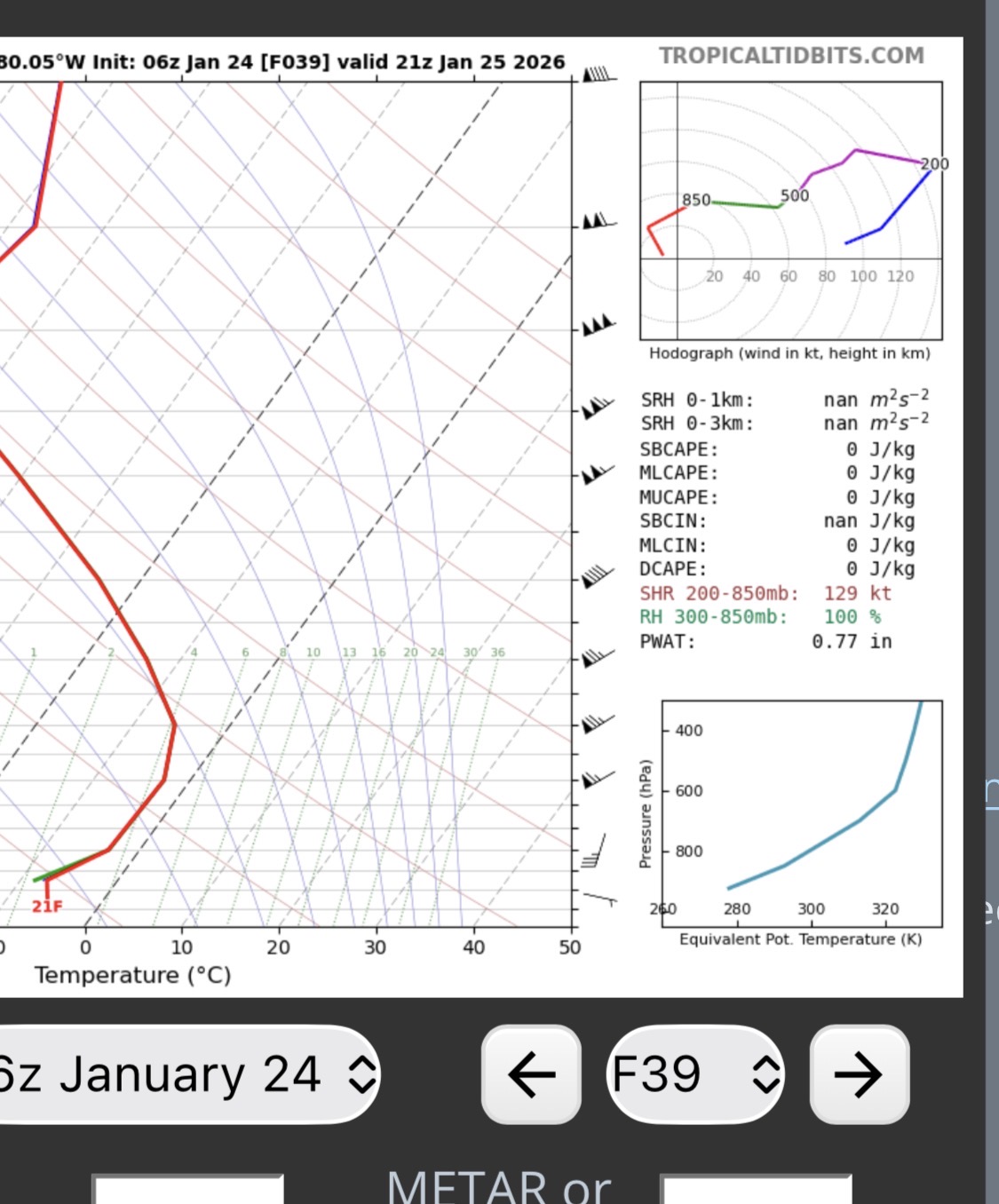
6z euro sounding looks pretty efficient, based on a quick read on pwats and snowfall.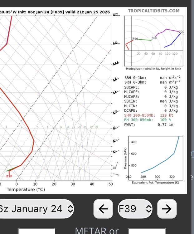
-
Pittsburgh/Western PA WINTER ‘25/‘26
CoraopolisWx replied to Burghblizz's topic in Upstate New York/Pennsylvania
-
Pittsburgh/Western PA WINTER ‘25/‘26
CoraopolisWx replied to Burghblizz's topic in Upstate New York/Pennsylvania
For me it’s a bit of PD2 and 2010. Both had strong WAA snowfall. -
Pittsburgh/Western PA WINTER ‘25/‘26
CoraopolisWx replied to Burghblizz's topic in Upstate New York/Pennsylvania
WSWarnings from Mexico to Montpelier. Impressive -
Pittsburgh/Western PA WINTER ‘25/‘26
CoraopolisWx replied to Burghblizz's topic in Upstate New York/Pennsylvania
For almost a week now, the GFS has been pretty consistent with a high qpf event for that time period. We’ll see if all of the guidance starts narrowing in on a solution by at least Wednesday. -
Pittsburgh/Western PA WINTER ‘25/‘26
CoraopolisWx replied to Burghblizz's topic in Upstate New York/Pennsylvania
Since 1900, out of the top 20 December monthly snow totals, only 2 of those seasons were below normal. So that’s a positive sign. -
Pittsburgh PA Fall 2025 Thread
CoraopolisWx replied to TheClimateChanger's topic in Upstate New York/Pennsylvania
12/9/92 might be my favorite storm, mostly for the nostalgia. -
Classic