wdrag
-
Posts
5,603 -
Joined
-
Last visited
Content Type
Profiles
Blogs
Forums
American Weather
Media Demo
Store
Gallery
Everything posted by wdrag
-
Maybe so. That does not explain downed trees in the interior I sure hope you’re safe. OKX issued an advisory. I look at it the 10 meter ASOs gust as roughly crown height. Broken branch dead or not. causes problem. Crosswind gusts are unsafe for many aircraft. Delays etc. Folks get unhappy with delays and then act irrationally. In Some cases. Impatience caused actions when plans are unexpectedly altered.
-
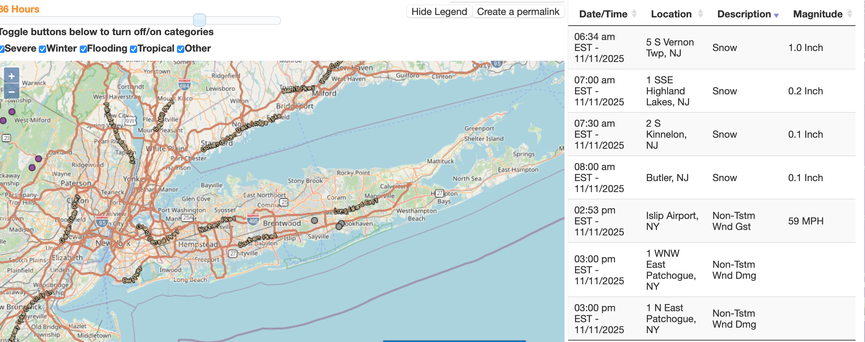
Looks like just about every airport NYC LI and around e PA have had 40 knots or greater. Think the impact is high ned minor. Worse than the last event and max gusts NYc may not arrive til 5pm
-
Max Gusts today in MPH per climate sites in NJ and NYS--please click for clarity.


-
Power outages (meters) at 145PM. in NJ, mostly nw NJ. Pennsylvania12,497 New Jersey10,874
-
Had tree detours inf Sussex County of NW NJ returning from Costco Roxbury NJ, SR15 Lafayette and CR637 Beemer Church Road in Wantage NJ around 1PM, probably fro branches-tree-wires down around 11A-Noon. Max wind gust below...generally highest near the east slopes of the Appalachians. From roughly 1030A-130P, the following generally ASOS-AWOS platform max G reports in that time frame,. KABE: Allentown, Lehigh Valley Intl Arpt, PA, United States [50kt, 26m/s] KBAF: Westfield, Barnes Municipal Airport, MA, United States [40kt, 21m/s] KBDR: Bridgeport, CT, United States [40kt, 21m/s] KBFD: Bradford, Bradford Regional Airport, PA, United States [41kt, 21m/s] KBGM: Binghamton, Binghamton Regional Airport, NY, United States [41kt, 21m/s] KBKW: Beckley, Raleigh County Memorial Airport, WV, United States [40kt, 21m/s] KBLF: Bluefield, Mercer County Airport, WV, United States [41kt, 21m/s] KBUF: Buffalo, Greater Buffalo Intl Arpt, NY, United States [42kt, 22m/s] KBWI: Baltimore, MD, United States [41kt, 21m/s] KCDW: Caldwell, Essex County Airport, NJ, United States [41kt, 21m/s] KCXY: Harrisburg, Capital City Airport, PA, United States [42kt, 22m/s] KELM: Elmira, Elmira / Corning Regional Airport, NY, United States [41kt, 21m/s] KESN: Easton / Newman Field, MD, United States [41kt, 21m/s] KFIT: Fitchburg, Fitchburg Municipal Airport, MA, United States [40kt, 21m/s] KFOK: Westhampton Beach, NY, United States [43kt, 22m/s] KFRG: Farmingdale, Republic Airport, NY, United States [41kt, 21m/s] KGAI: Montgomery, MD, United States [43kt, 22m/s] KHPN: White Plains, NY, United States [43kt, 22m/s] KIAD: Washington-Dulles Intl Arpt, VA, United States [41kt, 21m/s] KIAG: Niagara Falls, NY, United States [43kt, 22m/s] KILG: Wilmington, New Castle County Airport, DE, United States [42kt, 22m/s] KIPT: Williamsport, PA, United States [45kt, 23m/s] KLGA: New York, La Guardia Airport, NY, United States [41kt, 21m/s] KLNS: Lancaster, Lancaster Airport, PA, United States [46kt, 24m/s] KMDT: Harrisburg, Harrisburg Intl Arpt, PA, United States [47kt, 24m/s] KMIV: Millville, Millville Municipal Airport, NJ, United States [42kt, 22m/s] KMPO: Mount Pocono, PA, United States [45kt, 23m/s] KMRB: Martinsburg, WV, United States [48kt, 25m/s] KORH: Worcester, Worcester Regional Airport, MA, United States [40kt, 21m/s] KPHL: Philadelphia, Philadelphia Intl Arpt, PA, United States [41kt, 21m/s] KPNE: NE Philadelphia, PA, United States [41kt, 21m/s] KPYM: Plymouth, MA, United States [40kt, 21m/s] KRDG: Reading, Reading Regional Airport, PA, United States [46kt, 24m/s] KRSP: Campd David, MD, United States [49kt, 25m/s] KSWF: Newburgh / Stewart, NY, United States [40kt, 21m/s] KTEB: Teterboro, Teterboro Airport, NJ, United States [40kt, 21m/s] KTHV: York, York Airport, PA, United States [44kt, 23m/s] KVAY: Mount Holly, NJ, United States [41kt, 21m/s] KWRI: Mcguire AFB, NJ, United States [41kt, 21m/s] KXLL: Allentown-Queen City, PA, United States [40kt, 21m/s]
-
Power outages increasing nw NJ now
-
Allentown now 40 kt. White Plains 43 knot Mt Pocono 45 knot.
-
Allentown area significant power outage increase last hr in Northampton County.
-
Imo UPTON is conservative most of the time. Forecaster decision making and local office policy. Not sure how they verify. All I know. Writing it in an AFD doesn’t verify. Public product does. Warning Advisory verification does! That’s what I and others rely upon. If the 10A reports are the only ones for our area today then they verified with those reports outliers. maintain safety vigilance in strong gusty areas next 12 hours
-
KTEB and KLGA 40-41 KT past hour and many reports DCA/Philly and far S NJ 40-43 kt. Post 1015 am
-
sighhh.... maybe something will emerge prior to Dec 7, but for now am not excited by any possibility of a widespread 2+" snowfall for the I84 corridor . Ensembles are dead through Dec 1 and it will probably take awhile for the pattern to become more favorable after that. Oh well... guess all we have is a couple of episodes of scattered gusts 45+ MPH to witness for the rest of this month. Sort of boring and uninspiring for decorating but good weather to occasionally clean up outside. Need to add the hop in the step via our own heart. I added on at 752AM... that second week in Dec is our typical NYC CP first measurable. still a sigh... not like it used to be here in nw NJ.
-
Power outage baseline is too high this morning with significant outages in Middlesex and Ulster counties.
-
First reports... JST had 43KT prior to 5A. Here in the last 3 hours closer... KMDT: Harrisburg, Harrisburg Intl Arpt, PA, United States [40kt, 21m/s] KMPO: Mount Pocono, PA, United States [40kt, 21m/s]
-
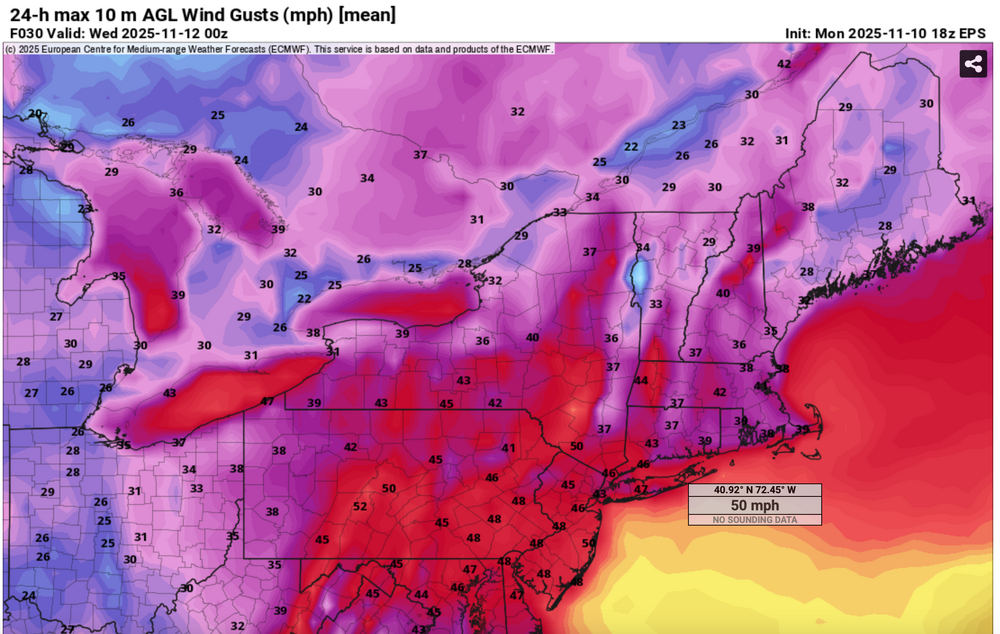
Not a major wind event, it still will have it's impacts- probably as the third wind event in the past three weeks. While many model gust tools do not forecast wind gusts above 45 MPH Sunday afternoon, the ECMWF gust tool does (seen on Pivotal) as do the soundings of the 00z/15 ECMWF and 06z/15 HRRR. Presuming these scattered gusts in excess of 45 MPH occur, there would be isolated power outages in our NYC subforum from a few broken tree branches or wind knocking down a few dead trees. Plan on air travel impact-delays Sunday afternoon, and possibly needing a little extra time to arrive at destinations (isolated detours?). Afternoon football games in NYS/NJ may be impacted by wind gusts? 535A/15
-
Probably threading wind advisory criteria early Saturday for Noon-10PM Sunday, 45-50 MPH gusts. Minor impact except air travel and where a wind blown branch crosses the road. Slot looks BGM-MPO through NYC-LI.
-
so far... rain may be a factor and wind... next wind event for us Sunday afternoon.... another marginal advisory situation... looks like G40-50 MPH.
-
So far, pretty placid relatively speaking for us here near NYC, into Thanksgiving.
-
We don't know exactly what drives an advisory--- and OKX and PHI may say it wasn't warranted for areal coverage etc. Who knows... My goal for the post was that the flurry situation was well documented as first for the season, AND, that the Blend of Models and most, if not all other modeling gust tools were inferior to the ECMWF gust tool. This is twice in succession that I've noticed the ECMWF has excelled one 40kt or greater gusts, even overcoming NAM and GFS limited R# (eddy) transfer for the 11/11 event. If all other models show 40KT plus gusts inclusive of the SPC HREF, better issue the advisory. If most don't...hesitate. Power outages increased for a time in NJ but not equivalent to the 31st when the trees were more fully leaved the gust criteria was exceeded even in the interior.
-
If indeed weak La Niña this winter? should snowfall departures be similar?
-
Philly max wind gusts... 00 NOUS41 KPHI 112159 PNSPHI DEZ001>004-MDZ012-015-019-020-NJZ001-007>010-012>027-PAZ054-055-060>062-070- 071-101>106-120959- Public Information Statement National Weather Service Mount Holly NJ 459 PM EST Tue Nov 11 2025 ...HIGHEST WIND REPORTS FOR NOVEMBER 11, 2025... Location Speed Time/Date Provider ...New Jersey... ...Atlantic County... Atlantic City Airport 46 MPH 1130 AM 11/11 ASOS Atlantic City 46 MPH 1240 PM 11/11 NJWXNET 2 ESE Pleasantville 44 MPH 0150 PM 11/11 AWS BRIGANTINE 41 MPH 1117 AM 11/11 CWOP Pleasantville Point 41 MPH 1229 PM 11/11 WXFLOW ...Burlington County... Mount Holly 44 MPH 0326 PM 11/11 ASOS Moorestown 41 MPH 1255 PM 11/11 NJWXNET McGuire AFB 38 MPH 0355 PM 11/11 AWOS ...Camden County... Pennsauken 44 MPH 1200 PM 11/11 NJWXNET Blue Anchor 35 MPH 0210 PM 11/11 RAWS ...Cape May County... 1.2 NW Avalon 52 MPH 0233 PM 11/11 HADS Cape May Harbor 49 MPH 1215 PM 11/11 HADS Cape May 47 MPH 1216 PM 11/11 WXFLOW Villas 45 MPH 0405 AM 11/11 DAVIS Ocean City 41 MPH 0137 PM 11/11 WXFLOW Cape May 39 MPH 1155 AM 11/11 AWOS Dennis Twp. 39 MPH 1225 PM 11/11 NJWXNET West Cape May 38 MPH 0225 PM 11/11 NJWXNET Woodbine Muni 38 MPH 1153 AM 11/11 AWOS North Wildwood 35 MPH 1215 PM 11/11 DAVIS ...Cumberland County... Fortescue 50 MPH 1200 PM 11/11 NJWXNET Millville 46 MPH 0208 PM 11/11 ASOS Upper Deerfield 40 MPH 0125 PM 11/11 NJWXNET Bivalve 37 MPH 1139 AM 11/11 HADS Greenwich 37 MPH 0327 PM 11/11 HADS ...Gloucester County... Kingsway Regional HS 42 MPH 1150 AM 11/11 MESOWEST Logan Twp. 35 MPH 0130 PM 11/11 NJWXNET ...Mercer County... Trenton 43 MPH 0203 PM 11/11 ASOS ...Middlesex County... Perth Amboy 43 MPH 0134 PM 11/11 WXFLOW Deans 36 MPH 1010 AM 11/11 RAWS 1 NNW Yorketown 36 MPH 0254 PM 11/11 AWOS South Amboy 35 MPH 0255 PM 11/11 DAVIS ...Monmouth County... 1.0 NW Keansburg 45 MPH 0139 PM 11/11 HADS Belmar Farmdale 43 MPH 0214 PM 11/11 AWOS SEA BRIGHT 43 MPH 0305 PM 11/11 CWOP Sea Girt 41 MPH 0105 PM 11/11 NJWXNET Monmouth 40 MPH 0153 PM 11/11 WXFLOW Cream Ridge 37 MPH 0135 PM 11/11 NJWXNET Oceanport 35 MPH 0140 PM 11/11 NJWXNET ...Morris County... Randolph 40 MPH 0325 PM 11/11 CWOP Morristown 35 MPH 1245 PM 11/11 AWOS ...Ocean County... Beach Haven 51 MPH 0216 PM 11/11 CWOP Mantoloking 49 MPH 0146 PM 11/11 WXFLOW Rutgers 49 MPH 1202 PM 11/11 WXFLOW Harvey Cedars 47 MPH 0150 PM 11/11 NJWXNET North Beach Haven 46 MPH 0105 PM 11/11 CWOP Tuckerton 45 MPH 1233 PM 11/11 HADS North Beach 42 MPH 1115 AM 11/11 DAVIS Seaside Heights 42 MPH 0209 PM 11/11 WXFLOW Toms River 41 MPH 0107 PM 11/11 AWOS Surf City 40 MPH 0115 PM 11/11 CWOP South Seaside Park 39 MPH 0129 PM 11/11 CWOP Brick 38 MPH 1225 PM 11/11 DAVIS Seaside Park 38 MPH 0315 PM 11/11 CWOP Trixies 38 MPH 0125 PM 11/11 WXFLOW Long Beach Township 37 MPH 0125 PM 11/11 DAVIS Berkeley Twp. 36 MPH 1210 PM 11/11 NJWXNET Ship Bottom 35 MPH 0330 PM 11/11 CWOP ...Salem County... Mannington Twp. 35 MPH 0325 PM 11/11 NJWXNET ...Somerset County... Somerville 35 MPH 0246 PM 11/11 ASOS ...Sussex County... High Point Monument 43 MPH 0140 PM 11/11 NJWXNET ...Warren County... Blairstown 37 MPH 1239 PM 11/11 AWOS Stewartsville 36 MPH 0135 PM 11/11 NJWXNET ...Pennsylvania... ...Berks County... Reading 45 MPH 0110 PM 11/11 ASOS Hopewell 43 MPH 0143 PM 11/11 RAWS LENHARTSVILLE 42 MPH 0315 PM 11/11 CWOP 2 WSW Hamburg 38 MPH 1010 AM 11/11 PADOT Sinking Spring 35 MPH 0113 PM 11/11 CWOP ...Bucks County... Burlington NOS 40 MPH 1224 PM 11/11 NOS-PORTS Doylestown 40 MPH 1240 PM 11/11 ASOS Newbold NOS 39 MPH 0300 PM 11/11 NOS-PORTS Kintnersville 38 MPH 1245 PM 11/11 CWOP Nockamixon 38 MPH 1043 AM 11/11 WXFLOW Perkasie 38 MPH 1235 PM 11/11 AWOS ...Chester County... White Clay Creek West Grove- 46 MPH 1150 AM 11/11 DEOS2 Coatesville 43 MPH 0315 PM 11/11 AWOS West Chester 43 MPH 0340 PM 11/11 AWOS Marsh Creek 41 MPH 1055 AM 11/11 WXFLOW Octoraro Creek Atglen 40 MPH 1150 AM 11/11 DEOS2 1 ESE West Sadsbury Twp 38 MPH 1225 PM 11/11 PADOT Cochranville 37 MPH 0239 PM 11/11 CWOP Oxford 36 MPH 1215 PM 11/11 CWOP Kimberton 35 MPH 0205 PM 11/11 DAVIS Red Clay Creek Kennett Squar 35 MPH 0105 PM 11/11 DEOS2 ...Delaware County... Upper Chichester 35 MPH 1215 PM 11/11 CWOP ...Lehigh County... Lehigh Valley Intl Airport 45 MPH 1054 AM 11/11 ASOS Queen City 44 MPH 1235 PM 11/11 AWOS Trexler 41 MPH 1143 AM 11/11 RAWS Macungie 39 MPH 1240 PM 11/11 CWOP New Tripoli 36 MPH 0110 PM 11/11 CWOP COOPERSBURG 35 MPH 1130 AM 11/11 CWOP ...Monroe County... Mt. Pocono 43 MPH 0825 PM 11/10 ASOS Wind Gap 36 MPH 0850 PM 11/10 PADOT ...Montgomery County... 1 SE Fort Washington 43 MPH 0125 PM 11/11 PADOT Philly Wings Field 39 MPH 0115 PM 11/11 AWOS Pottstown 39 MPH 0109 PM 11/11 ASOS Willow Grove 37 MPH 0200 PM 11/11 CWOP King Of Prussia 35 MPH 1125 AM 11/11 CWOP ...Northampton County... BATH 36 MPH 1021 AM 11/11 CWOP CATASAUQUA 36 MPH 1253 PM 11/11 CWOP ...Philadelphia County... Philadelphia Northeast 53 MPH 0214 PM 11/11 ASOS 1 SSE South Philadelphia 52 MPH 0210 PM 11/11 PADOT Philadelphia International 47 MPH 1154 AM 11/11 ASOS ...New Jersey... ...Maritime Stations... Sea Isle City 47 MPH 1245 PM 11/11 HADS 1.1 N Margate City 38 MPH 1257 PM 11/11 HADS &&
-
This was the EPS max gust tool from the 18z/10 (Monday) cycle for Tue. You can match with the wind gust reports. I added some LSR's as well. If interested click for clarity
-
There were two reports of trees down on e LI in the Local Storm Reports. Below shows the stronger ECMWF Wind gust tool easily prevailed over all other model guidance. 661 NOUS41 KOKX 120225 PNSOKX CTZ005>012-NJZ002-004-006-103>108-NYZ067>075-078>081-176>179-121425- Public Information Statement National Weather Service New York NY 925 PM EST Tue Nov 11 2025 ...HIGHEST WIND GUST REPORTS... Location Speed Time/Date Provider ...Connecticut... ...Fairfield County... St Lukes School 45 MPH 0417 PM 11/11 MESOWEST Bridgeport Airport 40 MPH 1058 AM 11/11 ASOS ...New Haven County... Bethany 47 MPH 0142 PM 11/11 CWOP Stony Creek 46 MPH 0155 PM 11/11 CWOP Lighthouse Point 45 MPH 1211 PM 11/11 WXFLOW New Haven Airport 40 MPH 0416 PM 11/11 ASOS ...New London County... Groton Airport 43 MPH 0340 PM 11/11 ASOS ...New Jersey... ...Bergen County... Teterboro Airport 43 MPH 0335 PM 11/11 ASOS ...Essex County... Caldwell 41 MPH 0156 PM 11/11 ASOS ...Union County... Newark Airport 45 MPH 0151 PM 11/11 ASOS ...New York... ...Kings County... South Slope 43 MPH 1056 AM 11/11 CWOP Brooklyn College 43 MPH 0400 PM 11/11 NYSM ...Nassau County... Bayville 53 MPH 0206 PM 11/11 WXFLOW Wantagh 41 MPH 0135 PM 11/11 NYSM MASSAPEQUA 40 MPH 1113 AM 11/11 CWOP Merrick 40 MPH 0255 PM 11/11 CWOP ...New York (Manhattan) County... Midtown Manhattan 45 MPH 0320 PM 11/11 NYSM Central Park 40 MPH 0204 PM 11/11 ASOS ...Orange County... Montgomery Airport 44 MPH 0406 PM 11/11 AWOS ...Queens County... NYC/La Guardia 48 MPH 0156 PM 11/11 ASOS Kew Garden Hills 47 MPH 0405 PM 11/11 NYSM NYC/JFK Airport 46 MPH 1155 AM 11/11 ASOS Breezy Point 40 MPH 1206 PM 11/11 WXFLOW ...Richmond County... College of Staten Island 44 MPH 0140 PM 11/11 NYSM 2 SE Elizabeth 43 MPH 0148 PM 11/11 NDBC ...Rockland County... Suffern 45 MPH 0400 PM 11/11 NYSM ...Suffolk County... Eatons Neck 61 MPH 0238 PM 11/11 WXFLOW Baiting Hollow 60 MPH 0319 PM 11/11 CWOP Islip Airport 59 MPH 0253 PM 11/11 ASOS Great Gull Island 54 MPH 0138 PM 11/11 WXFLOW Brookhaven 52 MPH 0315 PM 11/11 CWOP Farmingdale Airport 51 MPH 0219 PM 11/11 ASOS Southold 50 MPH 0305 PM 11/11 CWOP Shirley Airport 48 MPH 0316 PM 11/11 ASOS Westhampton Airport 48 MPH 0343 PM 11/11 ASOS Montauk Airport 47 MPH 1207 PM 11/11 ASOS Orient 46 MPH 0245 PM 11/11 CWOP Shoreham 46 MPH 0315 PM 11/11 DAVIS Ridge 46 MPH 0322 PM 11/11 CWOP Fishers Island Airport 44 MPH 0340 PM 11/11 WXFLOW West Gilgo Beach 42 MPH 0105 PM 11/11 CWOP Fire Island CG 42 MPH 0145 PM 11/11 WXFLOW Mecox Bay 42 MPH 0343 PM 11/11 WXFLOW Stony Brook 40 MPH 1040 AM 11/11 NYSM Stony Brook 40 MPH 0303 PM 11/11 CWOP ...Westchester County... White Plains Airport 53 MPH 0220 PM 11/11 ASOS ...Maritime Stations... ...Connecticut... Stongington Outer Breakwater 51 MPH 0222 PM 11/11 WXFLOW 1 ESE Norwalk 44 MPH 1127 AM 11/11 WXFLOW ...New Jersey... Jersey City 50 MPH 1158 AM 11/11 CWOP ...New York... 15 S Atlantic Beach 51 MPH 0350 PM 11/11 NDBC 26 SSE Robert Moses State Pa 49 MPH 0300 PM 11/11 NDBC Manhattan Dwntwn 49 MPH 0926 AM 11/11 AWOS Robbins Reef, NJ 48 MPH 1112 AM 11/11 NOS-PORTS Fire Island CG 46 MPH 0151 PM 11/11 WXFLOW Shinnecock 46 MPH 0335 PM 11/11 WXFLOW Point O Woods YC 45 MPH 1242 PM 11/11 WXFLOW Northport 43 MPH 0225 PM 11/11 DAVIS Kings Point 43 MPH 0418 PM 11/11 NOS-NWLON Larchmont Harbor 40 MPH 0112 PM 11/11 WXFLOW &&
-
Currently using 35658 observations from 5253 unique global stations over the past 3 hours. Last Updated: Tue Nov 11 20:31:19 UTC 2025 0 stations reporting wind gusts 70kt or stronger0 stations reporting wind gusts 60-69kt2 stations reporting wind gusts 50-59kt KISP: Islip, Long Island Mac Arthur Airport, NY, United States [51kt, 26m/s] 35 stations reporting wind gusts 40-49kt since Noon today. KACY: Atlantic City, Atlantic City Intl Arpt, NJ, United States [40kt, 21m/s] KAOO: Altoona, Altoona-Blair County Airport, PA, United States [45kt, 23m/s] KBWI: Baltimore, MD, United States [42kt, 22m/s] KFRG: Farmingdale, Republic Airport, NY, United States [44kt, 23m/s] KHPN: White Plains, NY, United States [46kt, 24m/s] KILG: Wilmington, New Castle County Airport, DE, United States [41kt, 21m/s] KISP: Islip, Long Island Mac Arthur Airport, NY, United States [42kt, 22m/s] KJFK: JFK Intl Arpt, NY, United States [40kt, 21m/s] KJRB: Manhattan/Wall Street Heliport, NY, United States [40kt, 21m/s] KLGA: New York, La Guardia Airport, NY, United States [42kt, 22m/s] KLNS: Lancaster, Lancaster Airport, PA, United States [42kt, 22m/s] KMIV: Millville, Millville Municipal Airport, NJ, United States [40kt, 21m/s] KMTP: Montauk, Montauk Airport, NY, United States [41kt, 21m/s] KORH: Worcester, Worcester Regional Airport, MA, United States [49kt, 25m/s] KPHL: Philadelphia, Philadelphia Intl Arpt, PA, United States [41kt, 21m/s] KPNE: NE Philadelphia, PA, United States [46kt, 24m/s] KPVD: Providence, RI, United States [40kt, 21m/s] KRSP: Campd David, MD, United States [43kt, 22m/s]
-
Many ASOS I95 PHL to LGA JFK 40 knot gusts now and power outages slowly increasing
-
KACY: Atlantic City, Atlantic City Intl Arpt, NJ, United States [40kt, 21m/s] KBWI: Baltimore, MD, United States [41kt, 21m/s] KILG: Wilmington, New Castle County Airport, DE, United States [41kt, 21m/s] KJRB: Manhattan/Wall Street Heliport, NY, United States [43kt, 22m/s] KLNS: Lancaster, Lancaster Airport, PA, United States [42kt, 22m/s] KPHL: Philadelphia, Philadelphia Intl Arpt, PA, United States [41kt, 21m/s] KRSP: Campd David, MD, United States [49kt, 25m/s] Above since 9A.