wdrag
-
Posts
5,603 -
Joined
-
Last visited
Content Type
Profiles
Blogs
Forums
American Weather
Media Demo
Store
Gallery
Everything posted by wdrag
-
Max G NJ coast via NJ climate sites. 52 MPH at Little Egg Harbor near ACY, so far. Will post CoCoRaHs totals tomorrow morning 9A. Flightaware misery map for NYC airports significant. STP's from OKX and PHI look reasonable.
-
NJ Power outage up to 4500
-
Wantage 0.3" at 8A. My AWN running high at 0.35 (heavier rainfall rates). EWR 0.22, LGA and CP .20. JFK 0.07, ISP .05 and BDR .01 amounts so far today as of the 12z ob.
- 246 replies
-
- 3
-

-

-
- heavy rain
- damaging wind? squalls?
- (and 2 more)
-
As of 630A... EPS/EPS AI best on rainfall through 12z... all other modeling slower-lower including SPC HREF. Near NYC spotty amounts of 1/4" per NYS mesonet and in NJ spotty amounts of 1/2". Sussex County NJ lagging for now with amounts least in NJ. G 40 MPH parts of NJ coast now. Power status NJ 1480 and NYS 350 ish which is NO big deal right now.
- 246 replies
-
- 2
-
-
- heavy rain
- damaging wind? squalls?
- (and 2 more)
-
OBS-Nowcast should go here when we start predawn Thursday. Modeling of the previously drier GEFS and SREF are becoming better with the 18z cycle and drifting east. The 00z/30 SPC HREF may be helpful when it completes around 0530z. No changes seem needed to the headline.
-
modeling differences with the 06 EPS Suites heavier as well as SPC HREF. If its drier than 1" it would be east of I95, I think . Otherwise all I see is a continued impact event as headlined Thu afternoon. Reality check tomorrow, maybe sooner via modeling, but for now (06z/29 suites)... I see little reason to change anything.
-
Probably my last til 8A tomorrow an then I'll be off line all day tomorrow roughly 830A-8P. NO changes to the thread headline... I like it very much as is. Mesoscale modeling will show bands of 3" and some spots 1/2-1". 18z HRRR and NAM have no dry slot til after 03z/31. 18z WPC continues with their 1-1.75" isohyets for virtually the entire subforum. They must have gone with the heavier 12z EPS/EPSAI ...maybe Deepmind? though I dont have access to Deep Mind. 12z CMCE and GEFS were less than WPC so there is always that possibility. The 12z ensembles were heavier than many of op runs. Lets see how it plays. I have not read any discussions today from NWS.. so there may be some reasoning I missed. PHI has started their advisory for coastal flooding NJ coast south of Monmouth. It's only a matter of time I think that the advisory expands northward, but FOLLOW NWS. I suspect a wind advisory issues for coastal sections tomorrow morning (6 hr window in the aft or eve depending on location) and reserving the back side. That prepares folks for some delays etc. Friday wind advisory possibility NJ/LI reserves for a later issuance. HSLC thunder and squally gust possible late Thu. There is going to be significant impact for a few hours Thursday, especially afternoon-eve. One final addition at 450P. NAM 5H 12 hr HFC cyclicly at least last 3 cycles near 200M in e PA around 06z/31. Should become a little unstable for a few hours ahead of it.
- 246 replies
-
- 1
-
-
- heavy rain
- damaging wind? squalls?
- (and 2 more)
-
Still overall AOB normal first 10 days... and models are "attempting" first flakes mix for I84 high terrain, esp 11/8-9. Nothing unusual.
-
Kind of agree... still not to give up hope since neg tilt, instability aloft. In bands... probably best eastern PA into central NYS northwest of the 850 low, but all modeling continues with beneficial amounts for the forum. Impossible for me to know for sure... ensembles (esp EC and ECAI ae larger than I anticipated when looking at their 00z/28 ops).
- 246 replies
-
- 1
-
-
- heavy rain
- damaging wind? squalls?
- (and 2 more)
-
There might be some impact from Melissa--adjusting the flow patterns, but for now... I'm not attributing Melissa indirectly -- I'd have to prove it w some science and that for me is not easily done. Speculation herein warranted but not for media as yes (gospel pronouncement). Basically what I see is a routine event Thursday... the 09z/28 WPC 3 day beneficial totals are within the 1 year repeat interval so its just a matter of impacts on travel. I don't see anything worse than thread headlined. Wind advisory coasts Thursday ahead of the low, and then maybe again behind it Friday afternoon-eve; scattered tree limbs down here and there for power outages, but not extensive unless we get a good squall-line (HSLC) event Thursday afternoon-evening. Coastal flooding limited to minor, imo-psurge values into minor have decreased on the GFS/GEFS/NAEFS. Therefore, its the previously exposed (Oct 12-13 event) coastal locations that seem most vulnerable to coastal flooding (NJ),. Still time to adjust but for now my anticipation has waned a bit due to the upper 5h low arcing northeastward through western-central PA.
- 246 replies
-
- 2
-
-
- heavy rain
- damaging wind? squalls?
- (and 2 more)
-
Last several GFS op cycles offering 4+ in a narrow band roughly MMU-POU... something to model monitor tomorrow. Likely my last on this til Tue am. Unsure whether PHI or OKX are looking at HSLC etc.
- 246 replies
-
- 2
-
-
- heavy rain
- damaging wind? squalls?
- (and 2 more)
-
High Shear Low Cape (HSLC) environment for e PA/NJ/LI Thu afternoon? Don't know. We'll monitor SPC etc on this. Right now flash density from the 12z/27 EC op has a possibility of thunder here Thu afternoon NJ/ NYC. Back tomorrow.
- 246 replies
-
- 2
-
-
- heavy rain
- damaging wind? squalls?
- (and 2 more)
-
Update through 658A/27... no changes. Ensemble modeling continues similar with two groups..eastward wetter GEFS suites and slightly westward EC suites. Results are similar. I am not planning to work outside Thursday in northwest NJ, cleaning my gutters of leaves the day before-Wed AM... might need standby DVD in case of internet-power outage Thu afternoon as all modeled products this morning are similar to what we saw yesterday, including the high likelihood of coastal flooding with the Thu aftn-evening high tide cycle. 06z GFS went a little ballistic on qpf and that is related to the nearly stand still Thu aft-evening inflow pattern with PW over 1.5", caused by a suddenly intensifying 5H HFC across NJ---I cant figure the reasons for that... almost like a breathing 5H low HFC... 200M HFC TN Valley a day or two before, then weakens across VA and suddenly strengthens PA/NJ Thurs. IF it happens, I'd have to add an inland flooding tag to the thread and update ARI since this sole GFS cycle has spot 6" amounts in se NYS. I'm not buying that solution right now. One thread change that I may have to make is beef up the chance of iso svr ... but will wait til Tuesday evening before any adjusting.
- 246 replies
-
- 3
-
-
-
- heavy rain
- damaging wind? squalls?
- (and 2 more)
-
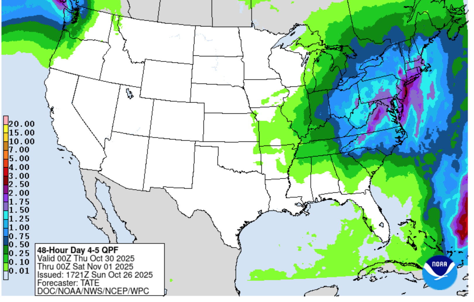
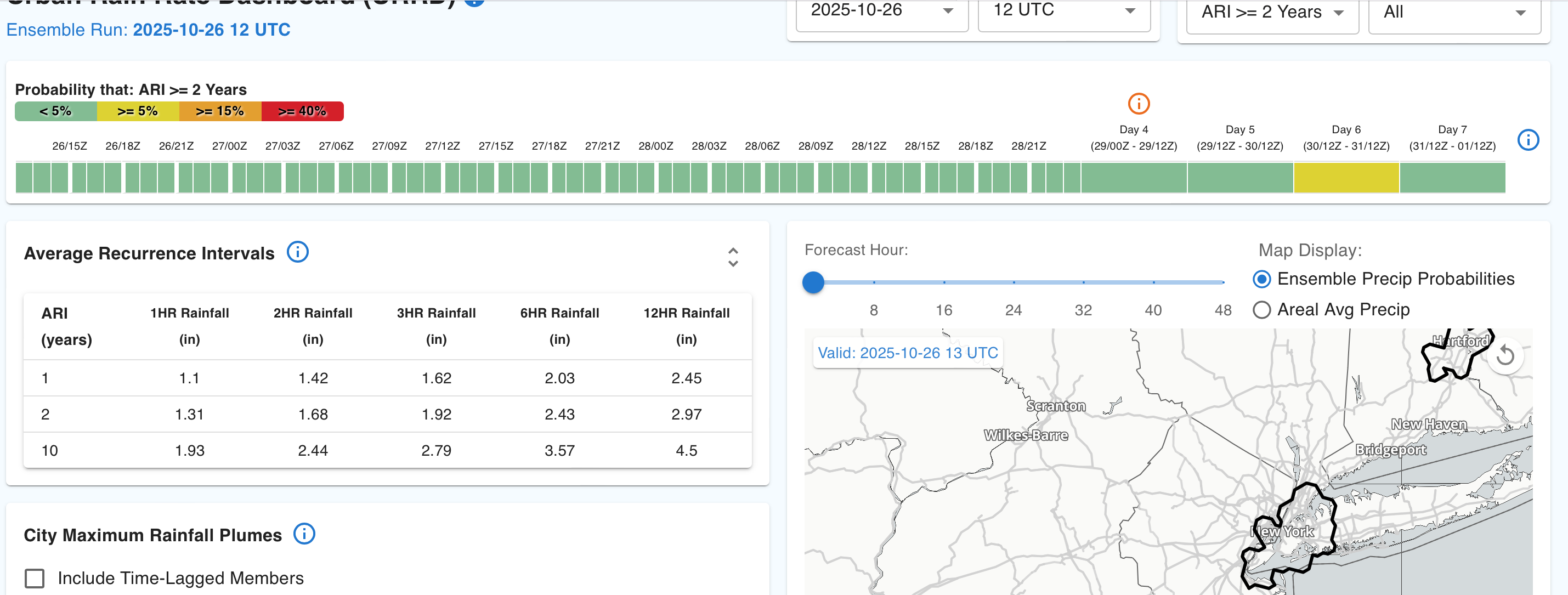
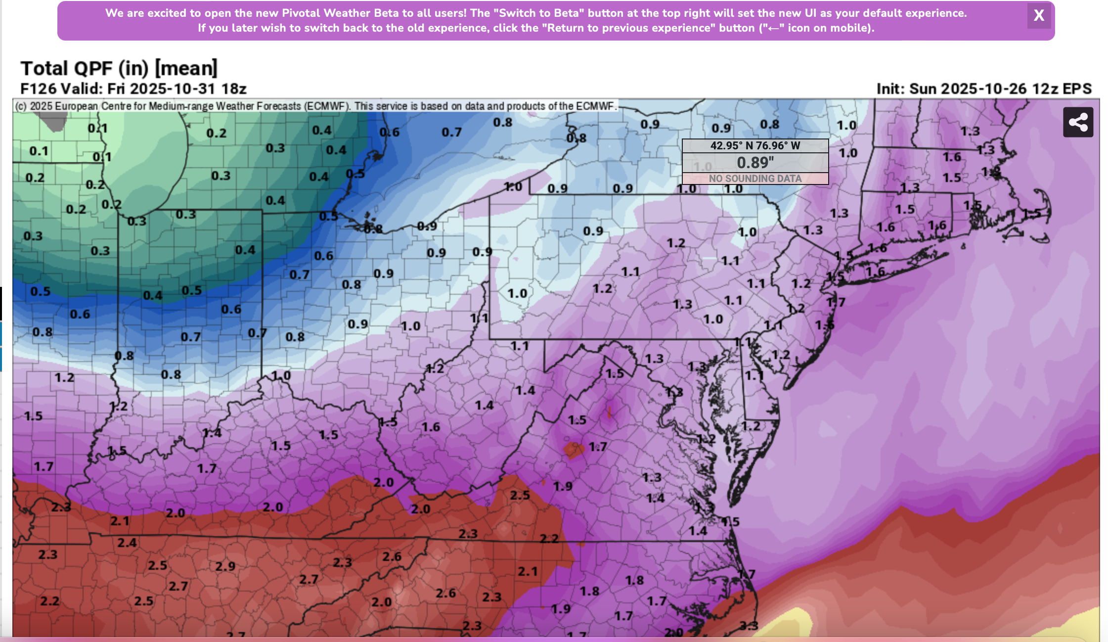
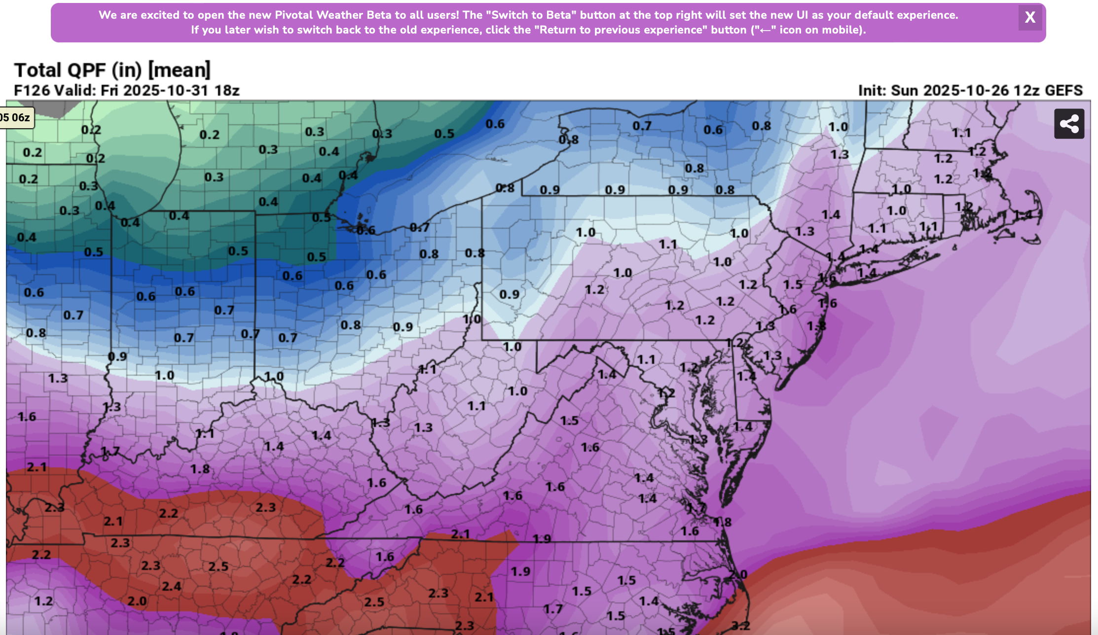
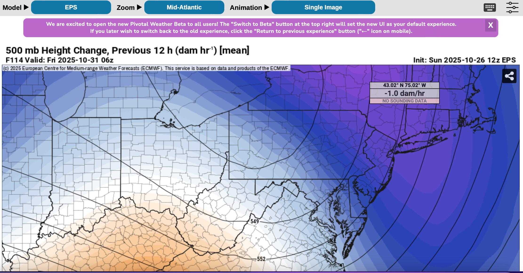
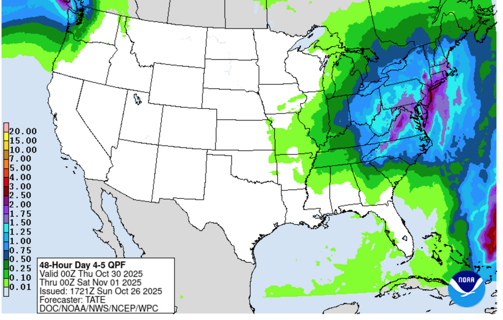
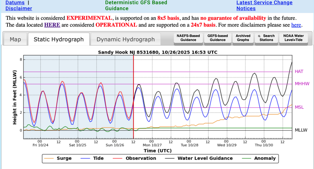
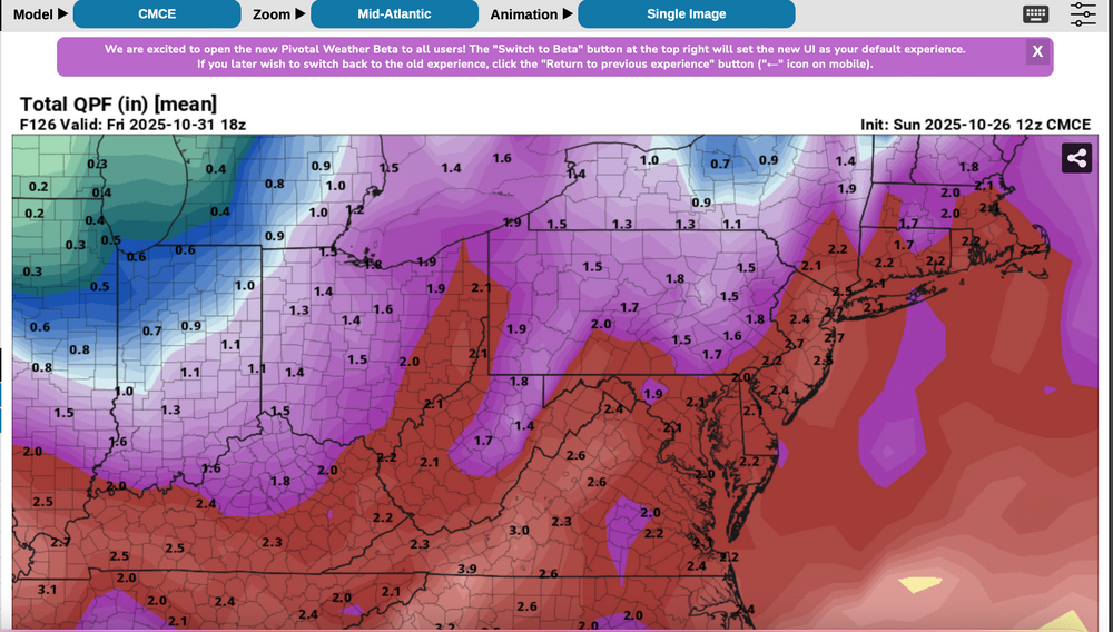
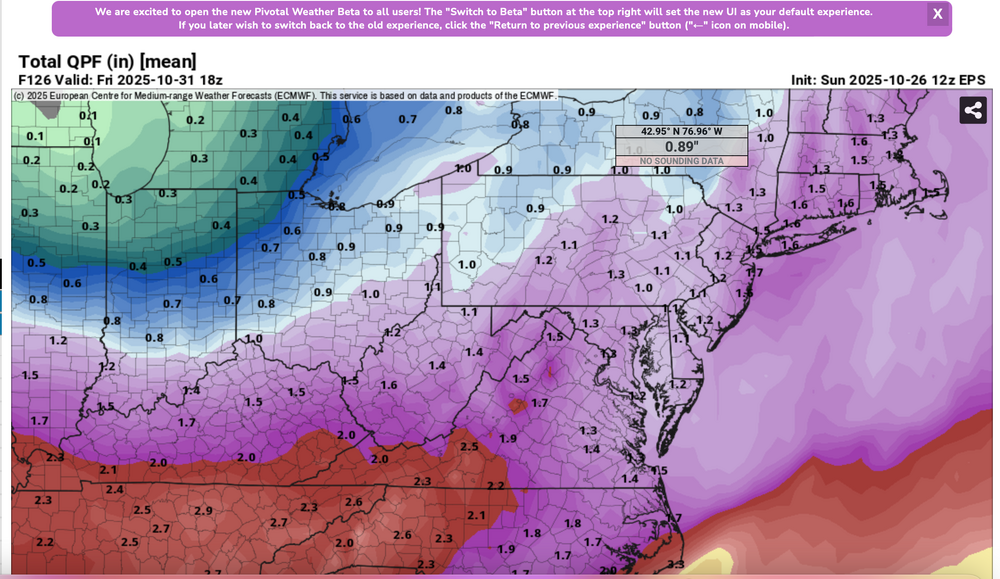
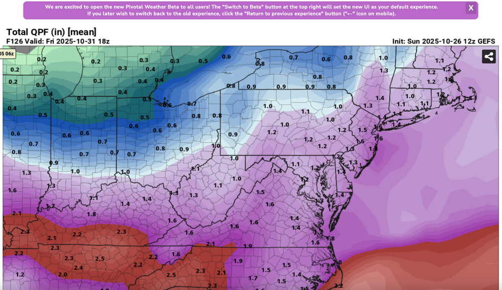
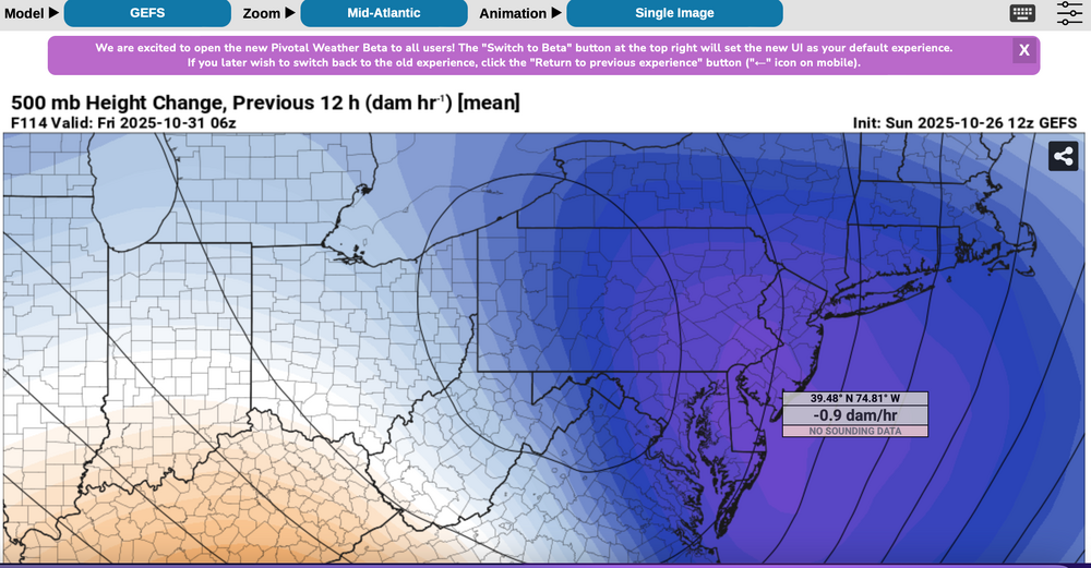
Please follow any NWS Watches, warnings, statements that may arise from this coming minor or moderate event. This is a D4-5 advance heads-up thread for those who have a need to be advised. Modeling has plenty of spread in solutions so that the ensembles are somewhat muted. There is no doubt in my mind that some sort of minor or possibly moderate impact event is coming. Modeling has been wavering for the past 4 days and hopefully uncertainties resolve by mid week. If I had plans as a motorist or via air travel Thursday-early Friday, I'd think about delays and how to minimize adverse impact, then possibly implement changes Tuesday or Wednesday Timing of the 6-10 hour worst case is uncertain. Beneficial rainfall should result in October totals at all NWS OKX-Upton climate sites roughly 3.3-4.3", within about 1/2" of normal. Not everyone will get 1"+ but the attached Sunday afternoon 10/26 WPC guidance is a best estimate for D4-5. Rainfall still could end up less than indicated. A graphic of average return interval (ARI) for various event amounts, at NYC, is attached-not alarming. This could still end up a routine event although I think wind can add impact. Rainfall intensity during one of the rush hours combined with potential for a period of east-southeast wind gusts 45-55 mph on the remaining wet fully leaved trees may result in a scattering of broken limb caused power outages, similar to the 10/12-13 event. Lunar cycle argues for maximum worst case coastal flooding in the minor category. Modeling from P-Surge is attached. It might be too robust (follow NWS), suggesting a worst cause 3 ft surge along parts of the coasts during the Thursday afternoon-evening high tide cycle (using Sandy Hook as example). Lowered pressure this time compared to 10/12-13 contributes to the surge. Please be aware ensembles are not showing much more than 50-55knot se inflow here, limiting potential for excessive rainfall and surge. There is a slightest chance for isolated severe however CAPE seems to be very limited, despite the favorable strong shear and diffluent upper level flow. A 100-150M 12 hour 500 MB Height Fall Center circles northeastward from the southeast central USA into PA/NJ early Friday. That helps drive the relatively short duration heavy rain event. Presuming the upper Low continues to evolve northward through PA into NYS the eastern Great Lakes there should be a progressive rapid improvement sometime Friday morning. Westerly winds may gust 25-35 MPH at times during Halloween evening but hopefully without any showers in the area. Ensemble rainfall from several modeling centers has been attached as something to look back upon Saturday 11/1 when all the totals are in. The 500MB ensembles attached also show the 12 hr HFC. Fairly modest in comparison to some of the operational cycles we've been seeing the past several days. If the 5h ensemble pattern prevails or is further west, then we've tracked a routine event. The thread current headline will eventually update if moderate impact potential decreases. For now this hopefully adequately summarizes what is on the table for rain/wind/coastal concerns. Let's see if its worth tracking. 620P/26


- 246 replies
-
- 12
-
-
-
- heavy rain
- damaging wind? squalls?
- (and 2 more)
-
At a 40th party now but I will get a tracker thread going for Thursday-Friday. Moderate impact 12 hour event 1-3 inches, all the other parameters mentioned earlier today. I just need computer time at home to phrase carefully. Should see the thread at 6pm. Have seen 12z/26 gfs and cmc ops. remember this is D5. Lots can go awry so let’s be a little cautious on anticipating too much wind and rain.
-
I think a little less on wind from 2 weeks ago... tides definitely less (lunar 1/4 moon) but if sfc Pres drops to 995 when it passes NYC then maybe similar to two weeks ago. Rainfall will distribute differently but a good chance of 1+. This is D5.. Many might not care a bout 1.5" rain and iso power outage. There isn't a threshold but if we publish--- then this may garner more attention outside our normal membership... I want it to be reliable which means succeeds. I'm on board as posted earlier but this is for group and I want to make sure the group shines in its attention. Two weeks ago had much better agreement on moderate impact and even the tides were just a little less than anticipated except central NJ coast. We've been talking about this for days. EC/ECAI moving the max HFC west of us bothered me... I kind of like this to maximize over NJ/LI/CT... the one consideration in favor of stronger wind is NORTHWARD MOVING HFC with sfc wind turning se-s... if the sfc low does pass west. GEFS and CMCE have me most concerned about 6-12 hr moderate impact. That may not help... maybe this does. Once I thread it... I sweat it... just like I did in NWS with HWO etc... sleep interrupted worry. I feel some sort of responsibility to what I post... Just not quite confident enough and I do not need the naysayers saying I told you so. I think we have time. Probably offline til 3P.
-
Confusion emoji to me means uncertainty. Over the years of publishing for the NWS, I learned maybe a little... self discipline is a desired trait as is patience. While I think something, I prefer to be mostly correct in the expected reality--especitally D5. I'll have much more time this evening to balance the tipping point for a thread. Right now, our 06z/26 evaluated Average Return Interval for LGA is 9% for a 2 year or less return rate. That's not very high.
-
No thread yet--- not at tipping point for a 60% or greater moderate impact worthy forum event. WPC increased their qpf overnight. GFS and CMC modeling more ominous and even the 5H westward EC suite putting us on the edge but for now, all obs-disc can remain here. Will rereview late today-don't want to overstate. This will have travel impact here...certainly late Thu-early Fri and those who have to be somewhere on time might consider possible adjustments if below comes to fruition. To me... looks like minimum 1/2- maximum 3" rain event with max coastal gust 45-55 MPH late Thu-early Fri when it should be at its worst here w associated leafed tree breakage inducing power outages. Minor coastal flooding possible Thu afternoon or Fri morning high tide cycle but first quarter lunar cycle is not favorable for easier flooding.. Max 2-3" rainfall axis could still split the forum to the west and east but for now the target is as WPC has it... I95 eastward and so if all goes well-beneficially- we'll see October rainfall end up within 1/2" of normal... somewhere between 3.3-4.3"--thats a guess that sides with the WPC 09z rainfall forecast. Noting CP October rainfall is 0.4" above all other OKX Climate sites. Will check in late today--have a good day.
-
NO thread before tomorrow morning. Surprisingly WPC DECREASED the expected rainfall in its afternoon forecast. Yet...all 12z ensemble models are same or increased amounts with CMCE leading the way. Could be routine less than 1" event... I think more than that due to likely southern track scoop, 150M 12 hr HFC passing across PA and a pretty strong 5H jet. Have to go with what will work best for the outcome which is modeled with varying solutions. Waiting it out. Maybe tomorrow morning at 630A... could end up <1" but I thiink significantly more for a part of the forum with wind 50+ for a 6 hr period Thu or early Fri. Patience and model watching...
-
On modeling while awaiting a hayride return.., imo ballon launches help confirm but imo, satellite,aircraft . Radar all contribute to improved modeling. We wouldn’t have had a clue in the 20th century. Modeling is pretty darn good and is the reason threads are startednonce some sort mood reliable agreement is reached. We evaluate the threads once started. Today’s D5 is reliable telling you whether something significant will happen. We on this forum have a difference of opinion. Model sensitivity to theNew England trough is part of the problem.? Others in NWS can explain
-
Am in the midst of Halloween fun for my 3 year old granddaughter. My goal is to review the 12z EC/ECAI and then get going on a threat either 5-6P or after 830P. 12z GS ballistic like the prior EC, even more so. So, need to step back and fully assess late today. Seemingly a moderate impact player ahead for Thu-Fri (rain/wind/power and minor CF). Note some modeling starts showery rains Tuesday.
-
If a thread creates, it wont be until at least 6PM.. family considerations. I might post a one liner that one is coming, prior to 6P. Lot's of solution spread and that's why the ensembles are so timid. I am pretty sure the ensembles are too weak.
-
fwiw...Nov thread is up with no nuance from me.
-
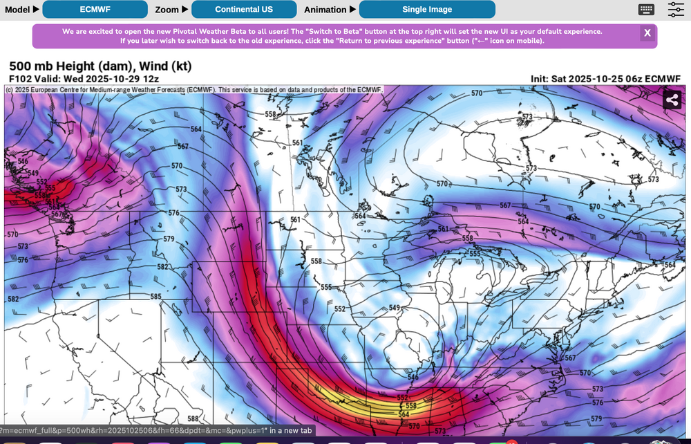
06z EC 6 hr max G over 60MPH near NYC-NNJ coast. long ways to go but the jet features argue for a moderate impact event Wednesday night-Thursday. EC upper level difference is large. Lack of ML CAPE limits potential for SVR but if modeling continues this is going to be an impact event. No thread - just reviewing for. 12 HOUR primary event Thursday.
-
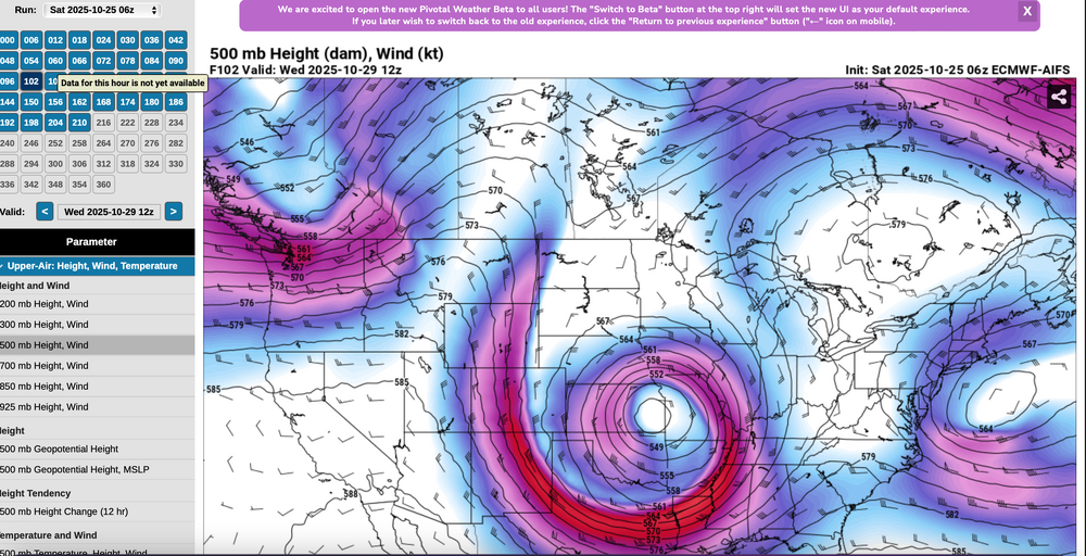
6z/25 EC and ECAI 5H at the same time - 102 hours out... note the huge difference in the ops at D4 off the east coast-New England-Great Lakes. Long ways to go to resolve what will happen.