

weathermedic
-
Posts
2,235 -
Joined
-
Last visited
Content Type
Profiles
Blogs
Forums
American Weather
Media Demo
Store
Gallery
Everything posted by weathermedic
-
TWC future radar has those showers/storms making it to the city around 1:30am
-
Watch expanding?
-
-
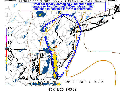
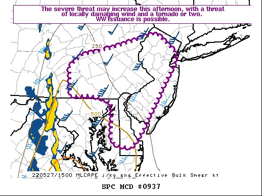
Well that escalated quickly. TORNADO WATCH OUTLINE UPDATE FOR WT 251 NWS STORM PREDICTION CENTER NORMAN OK 1135 AM EDT FRI MAY 20 2022 TORNADO WATCH 251 IS IN EFFECT UNTIL 700 PM EDT FOR THE FOLLOWING LOCATIONS NJC005-007-015-019-021-023-025-027-029-033-035-037-041-202300- /O.NEW.KWNS.TO.A.0251.220520T1535Z-220520T2300Z/ NJ . NEW JERSEY COUNTIES INCLUDED ARE BURLINGTON CAMDEN GLOUCESTER HUNTERDON MERCER MIDDLESEX MONMOUTH MORRIS OCEAN SALEM SOMERSET SUSSEX WARREN
-
Severe t-storm warnings with the MCS in south central PA. Still looks quite healthy on the radar.
-
Heat Advisories for areas north and west of NYC. Also seems as if the thunderstorm potential increased slightly: As the ridging attempts to get established and mid level shortwave will begin to approach and work through from the CWA. This MCC, or what`s left of it is now progged by most near term guidance to slide through late in the day and into this evening. There is uncertainty as to how much this MCC / MCV can maintain itself as it works east of the Appalachians and closer to the Atlantic seaboard. The instability and convection should become more elevated as it works east as it encounter the more stable air and relatively lower dewpoint / virtual temperature near surface profile. Look for a thunderstorm / thundershower chance from west to east as this system pushes through. This will ride basically north of a warm front down to the south. The remnant MCC /MCV should then eject to the ENE towards midnight. Thereafter the warm front approaches and pushes through towards daybreak Saturday morning. Look for a good deal of clouds and low level moisture to persist through much of the night until the warm front can clear the area. Lows will be above normal with cloud cover in place, along with patchy fog in spots, especially where rain can occur and moisten the ground
-
Storm in northern Queens just got severe warned.
-
They postponed the Mets game for this
-
The entire line up and down in NYS from the Canadian border to the PA/NJ border is severe warned.
-
Nice slug of rain on radar east of NJ/south of LI heading north. Should be a few hours worth of rain later this afternoon into the evening if it holds together.
-
Temp 58, RH down to 16% with a DP of 12 at my station. Pretty dry considering it being at night and on a stiff NE wind.
-
Not often RH stays in the 25 percent range with a persistent NE wind. Temp up to 61 from a morning low of 47 at my station. Strong May sun doing its work. Imagine how warm we would be if the wind was NW-W.
-
Up to 1.80 inches here so far.
-
1.25 of rain total so far at my station.
-
Flood Warning National Weather Service New York NY 912 PM EDT Thu Apr 7 2022 NJC003-013-017-031-039-NYC071-085-087-119-080415- /O.NEW.KOKX.FA.W.0001.220408T0112Z-220408T0415Z/ /00000.0.ER.000000T0000Z.000000T0000Z.000000T0000Z.OO/ Bergen NJ-Essex NJ-Hudson NJ-Passaic NJ-Union NJ-Orange NY-Richmond (Staten Island) NY-Rockland NY-Westchester NY- 912 PM EDT Thu Apr 7 2022 ...FLOOD WARNING IN EFFECT UNTIL 1215 AM EDT FRIDAY... * WHAT...Flooding caused by excessive rainfall is expected. * WHERE...Portions of northeast New Jersey and southeast New York, including the following counties, in northeast New Jersey, Bergen, Essex, Hudson, Passaic and Union. In southeast New York, Orange, Richmond (Staten Island), Rockland and Westchester. * WHEN...Until 1215 AM EDT. * IMPACTS...Flooding of rivers, creeks, streams, and other low-lying and flood-prone locations is imminent or occurring. Streams continue to rise due to excess runoff from earlier rainfall. It will take several hours for all the water from these storms to work through local drainage systems in urban areas. * ADDITIONAL DETAILS... - At 912 PM EDT, Doppler radar indicated heavy rain due to heavy rain and thunderstorms. Flooding is ongoing or expected to begin shortly in the warned area. Between 1.5 and 2.5 inches of rain have fallen. - Additional rainfall amounts of 1 to 1.5 inches are possible in the warned area. - Some locations that will experience flooding include... Newark, Paterson, Elizabeth, Passaic, Wayne, Hoboken, Plainfield, Bloomfield, Hackensack, Linden, New City, Orange, Bergenfield, Paramus, Ridgewood, Summit, Lyndhurst, Millburn, Monsey and Rutherford.
-
Special Weather Statement National Weather Service New York NY 910 PM EDT Thu Apr 7 2022 CTZ009-NJZ002-004-006-103>106-NYZ067>073-080200- Southern Fairfield CT-Hudson NJ-Eastern Essex NJ-Western Bergen NJ- Western Passaic NJ-Western Essex NJ-Eastern Bergen NJ- Eastern Passaic NJ-Rockland NY-Orange NY-Putnam NY- Southern Westchester NY-Bronx NY-New York (Manhattan) NY- Northern Westchester NY- 910 PM EDT Thu Apr 7 2022 ...Strong thunderstorms will impact portions of southern Fairfield, Hudson, Passaic, Bergen, northeastern Essex, Westchester, southeastern Orange, Putnam, Bronx, Rockland and New York (Manhattan) Counties through 1000 PM EDT... At 908 PM EDT, Doppler radar was tracking strong thunderstorms along a line extending from Greenwood Lake to Mott Haven. Movement was northeast at 45 mph. HAZARD...Wind gusts 40 to 45 mph. SOURCE...Radar indicated. IMPACT...Gusty winds could knock down tree limbs and blow around unsecured objects. Locations impacted include... Jersey City, Yonkers, Paterson, Stamford, Norwalk, New Rochelle, Passaic, White Plains, Wayne, Mott Haven, Hoboken, Bloomfield, East Tremont, Hackensack and New City.
-
Nice cell over the central Nassau/Suffolk border area. Any reports?
-
Date on the bottom one is from Nov 13, 2021
-
.75 inches total so far here.
-
 Wind gusted to 44 mph just now at my station.
 -
Temp down to 32. Precip stopped for now. Wind gust to 34 mph at my station.
-
URGENT - WINTER WEATHER MESSAGE National Weather Service New York NY 307 PM EST Fri Mar 11 2022 CTZ009-NJZ006-NYZ071>075-176-178-120415- /O.NEW.KOKX.WW.Y.0015.220312T1400Z-220313T0000Z/ Southern Fairfield-Hudson-Southern Westchester- New York (Manhattan)-Bronx-Richmond (Staten Island)- Kings (Brooklyn)-Northern Queens-Southern Queens- 307 PM EST Fri Mar 11 2022 ...WINTER WEATHER ADVISORY IN EFFECT FROM 9 AM TO 7 PM EST SATURDAY... * WHAT...Snow expected, along with the refreezing of wet surfaces. Total snow accumulations of 1 to 3 inches. Winds gusting as high as 50 mph. * WHERE...Portions of northeast New Jersey, southern Connecticut and southeast New York. * WHEN...From 9 AM to 7 PM EST Saturday. * IMPACTS...Plan on slippery road conditions. Gusty winds could bring down tree branches. * ADDITIONAL DETAILS...Temperatures will fall quickly during the day Saturday resulting in a quick freezing some standing water resulting in difficult travel.
-
Wind Advisory issued for Long Island: URGENT - WEATHER MESSAGE National Weather Service New York NY 304 PM EST Fri Mar 11 2022 NYZ078>081-177-179-120415- /O.NEW.KOKX.WI.Y.0006.220312T1600Z-220313T0500Z/ Northwest Suffolk-Northeast Suffolk-Southwest Suffolk- Southeast Suffolk-Northern Nassau-Southern Nassau- 304 PM EST Fri Mar 11 2022 ...WIND ADVISORY IN EFFECT FROM 11 AM SATURDAY TO MIDNIGHT EST SATURDAY NIGHT... * WHAT...Northwest winds 25 to 35 mph with gusts up to 50 mph expected. * WHERE...Northwest Suffolk, Northeast Suffolk, Southwest Suffolk, Southeast Suffolk, Northern Nassau and Southern Nassau Counties. * WHEN...From 11 AM Saturday to midnight EST Saturday night. * IMPACTS...Gusty winds could blow around unsecured objects. Tree limbs could be blown down and a few power outages may result. * ADDITIONAL DETAILS...In addition to the wind, rain will change over to snow by Saturday afternoon before ending. At least a coating of snow is expected for most areas. As temperatures drop below freezing by late afternoon into the evening, refreezing is possible on some surfaces, creating the potential for hazardous travel.
-
EWR gusted to 59.8 mph
-
Heavy rain with a wind gust to 37 mph at my station.

