weathermedic
-
Posts
2,235 -
Joined
-
Last visited
Content Type
Profiles
Blogs
Forums
American Weather
Media Demo
Store
Gallery
Everything posted by weathermedic
-

OBS-Nowcast Noon Saturday 2/15-Noon Monday 2/17
weathermedic replied to wdrag's topic in New York City Metro
From the OKX AFD at 4:18pm: NEAR TERM /UNTIL 6 AM MONDAY MORNING/... The secondary low was deepening over the New York City metro area at 20Z with a warm front through Long Island, reaching the north shore. The warm front may reach into coastal Connecticut before the low tracks northeast and a cold front moves through early this evening. The low reaches southeastern Canada this evening and then remains nearly stationary. With cold advection and strong gradient westerly flow, gusts are still expected to reach Wind Advisory levels this evening, 45 to near 55 mph, and continue into Monday. The Wind Advisory remains in effect through Monday afternoon for the entire region. -
OBS-Nowcast Noon Saturday 2/15-Noon Monday 2/17
weathermedic replied to wdrag's topic in New York City Metro
Not to mention the dense fog in areas where the warm front has gone through -
OBS-Nowcast Noon Saturday 2/15-Noon Monday 2/17
weathermedic replied to wdrag's topic in New York City Metro
Southern half of Long Island in the strong southerly flow. Southern NJ temps in 50s-low 60s. Winds cranking as well -
OBS-Nowcast Noon Saturday 2/15-Noon Monday 2/17
weathermedic replied to wdrag's topic in New York City Metro
Flipped to sleet here. About 1/4 inch of snow prior. -
With what looks like strong winds accompanying the snow, ratios may not be ideal since the snowflakes will be getting broken up, not allowing for maximum “fluffiness”
-
Looks great, however a couple of things to keep in mind. It’s the GFS. It’s a week away. Looks like it’s developing a double barrel low off the coast. Those usually don’t work out too well for us.
-
Only sticking to colder surfaces. Temp now down to 32 here in Sheepshead Bay.
-
Measured 1.75 of snow and 1.25 of sleet. Grand total of 3 inches here in Sheepshead Bay Brooklyn.
-
Changing over to sleet now after 1.75 inches of snow here in southern Brooklyn.
-
Just measured 1.5 inches here in Sheepshead Bay Brooklyn. Still moderate snow. Winds have shifted from the south to the east. 32/29
-
NYC Sanitation just gave the order to "drop the plows" so it's piling up on the streets.
-
32/27 with moderate to heavy snow. Good solid coating on everything. Streets whitened up also.
-
35 now with light wet snow falling here in Sheepshead Bay Brooklyn.
-
36, southerly wind and rain mixed with some flakes here in Sheepshead Bay Brooklyn. Edit: Of course sanitation is salting here.
-
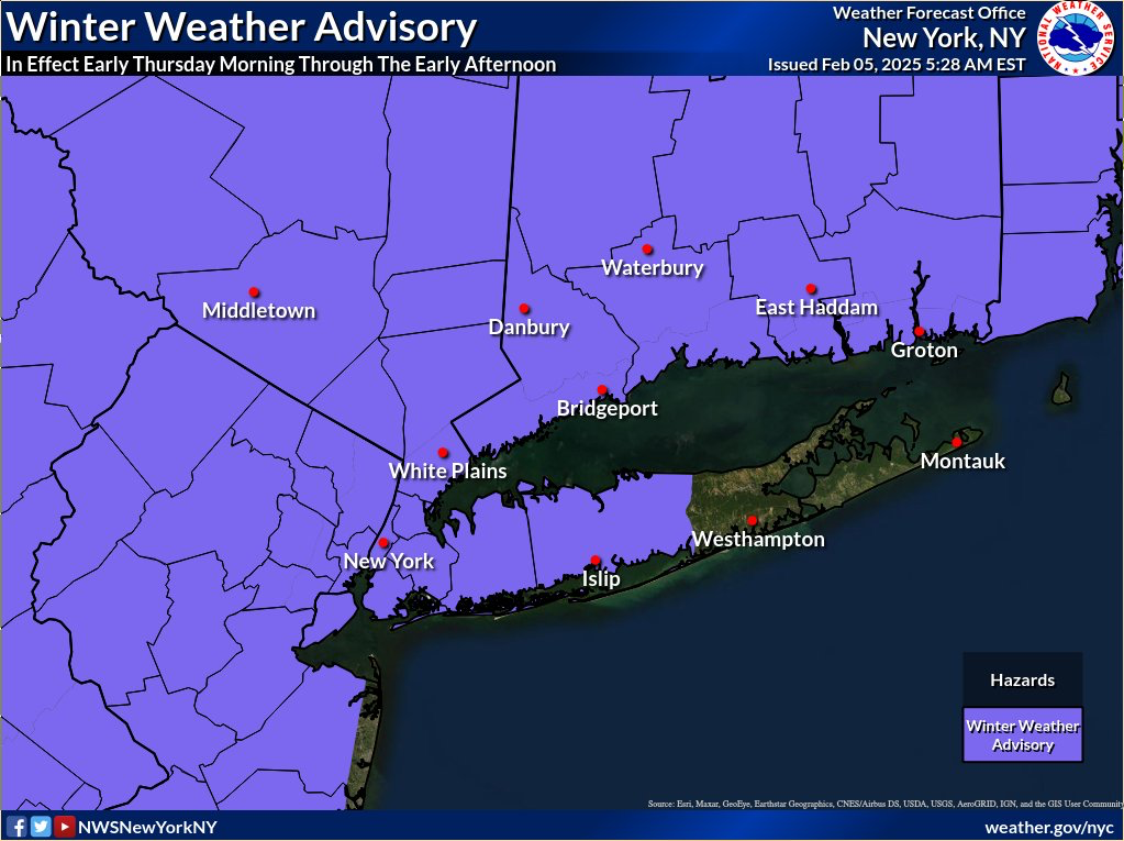
Wind advisory for the entire area today
-
From the NWS New York X (formerly Twitter) feed: Once again our weather balloon measured upper level wind speeds of 203 knots (234 mph) at a pressure level of 243 mb (around 34,000 ft)! This makes the 12th such observation of 200+ knot winds from our site, dating back to 1952.
-
Don't forget the Con Ed manholes here in the city which will inevitably result in several manhole fires
-
-8 at Montgomery according to the 5am NWS Obs. Coldest reading on that obs.
-
2.5 inches here in Sheepshead Bay
-
Listening to NYC Sanitation on the scanner. Bosses gave the orders for the trucks to drop their plows.