

weathermedic
-
Posts
2,235 -
Joined
-
Last visited
Content Type
Profiles
Blogs
Forums
American Weather
Media Demo
Store
Gallery
Everything posted by weathermedic
-

Two Mdt to high impact events NYC subforum; wknd Jan 6-7 Incl OBS, and mid week Jan 9-10 (incl OBS). Total water equiv by 00z/11 general 2", possibly 6" includes snow-ice mainly interior. RVR flood potential increases Jan 10 and beyond. Damaging wind.
weathermedic replied to wdrag's topic in New York City Metro
1.21 inches so far and coming down heavy. OKX issued a flood warning: Flood Warning National Weather Service New York NY 934 PM EST Tue Jan 9 2024 NJC003-013-017-039-NYC005-047-061-081-085-100530- /O.NEW.KOKX.FA.W.0003.240110T0234Z-240110T0530Z/ /00000.0.ER.000000T0000Z.000000T0000Z.000000T0000Z.OO/ Bergen NJ-Essex NJ-Hudson NJ-Union NJ-Bronx NY-Kings (Brooklyn) NY-New York (Manhattan) NY-Queens NY-Richmond (Staten Island) NY- 934 PM EST Tue Jan 9 2024 ...FLOOD WARNING IN EFFECT UNTIL 1230 AM EST WEDNESDAY... ...REPLACES FLOOD ADVISORY... * WHAT...Urban area and small stream flooding caused by excessive rainfall is expected. * WHERE...Portions of northeast New Jersey, including the following counties, Bergen, Essex, Hudson and Union and southeast New York, including the following counties, Bronx, Kings (Brooklyn), New York (Manhattan), Queens and Richmond (Staten Island). * WHEN...Until 1230 AM EST. * IMPACTS...Flooding of rivers, creeks, streams, and other low-lying and flood-prone locations is imminent or occurring. * ADDITIONAL DETAILS... - At 934 PM EST, Doppler radar indicated heavy rain. Flooding is already occurring in the warned area. Between 0.5 and 1.5 inches of rain have fallen. - Additional rainfall amounts of 1 to 1.5 inches are possible in the warned area. - Some locations that will experience flooding include... Newark, Jersey City, Jamaica, Flatbush, Flushing, Bayonne, Mott Haven, Hoboken, East Tremont, Hackensack, Bergenfield, Paramus, Coney Island, Lyndhurst, Rutherford, Secaucus, Harrison, Rockaway Beach, Ridgefield and Todt Hill. - http://www.weather.gov/safety/flood -
Two Mdt to high impact events NYC subforum; wknd Jan 6-7 Incl OBS, and mid week Jan 9-10 (incl OBS). Total water equiv by 00z/11 general 2", possibly 6" includes snow-ice mainly interior. RVR flood potential increases Jan 10 and beyond. Damaging wind.
weathermedic replied to wdrag's topic in New York City Metro
Gusting to 31 mph at JFK last hour- 3,610 replies
-
- 1
-

-
- snow
- heavy rain
- (and 5 more)
-
Two Mdt to high impact events NYC subforum; wknd Jan 6-7 Incl OBS, and mid week Jan 9-10 (incl OBS). Total water equiv by 00z/11 general 2", possibly 6" includes snow-ice mainly interior. RVR flood potential increases Jan 10 and beyond. Damaging wind.
weathermedic replied to wdrag's topic in New York City Metro
Empty trailer ban on the NYS Thruway (I-90) with at least one tractor trailer blown over between exits 59-60 earlier this morning.- 3,610 replies
-
- 2
-

-
-
- snow
- heavy rain
- (and 5 more)
-
Two Mdt to high impact events NYC subforum; wknd Jan 6-7 Incl OBS, and mid week Jan 9-10 (incl OBS). Total water equiv by 00z/11 general 2", possibly 6" includes snow-ice mainly interior. RVR flood potential increases Jan 10 and beyond. Damaging wind.
weathermedic replied to wdrag's topic in New York City Metro
Almost the entire eastern U.S. east of the Mississippi is covered with some kind of precipitation, snow, rain and severe in the south. Not a very common occurrence. Gives you an idea of the dynamics/moisture with this system.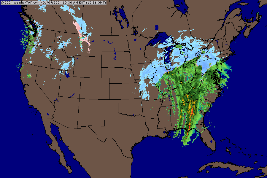
- 3,610 replies
-
- 2
-
-
- snow
- heavy rain
- (and 5 more)
-
Two Mdt to high impact events NYC subforum; wknd Jan 6-7 Incl OBS, and mid week Jan 9-10 (incl OBS). Total water equiv by 00z/11 general 2", possibly 6" includes snow-ice mainly interior. RVR flood potential increases Jan 10 and beyond. Damaging wind.
weathermedic replied to wdrag's topic in New York City Metro
The good thing about high winds in the winter months is that most of the trees do not have leaves on them so there isn't as much resistance.- 3,610 replies
-
- 2
-
-
- snow
- heavy rain
- (and 5 more)
-
Two Mdt to high impact events NYC subforum; wknd Jan 6-7 Incl OBS, and mid week Jan 9-10 (incl OBS). Total water equiv by 00z/11 general 2", possibly 6" includes snow-ice mainly interior. RVR flood potential increases Jan 10 and beyond. Damaging wind.
weathermedic replied to wdrag's topic in New York City Metro
From Upton: The High Wind Warning has been expanded to include the Bronx and Manhattan from 6 PM tonight to 6 AM tomorrow. Southeast winds of 20 to 30 mph with gusts of 65 mph are expected inland, with 25 to 35 mph winds and gusts as high as 70 mph anticipated along the coast. The period of strongest winds will be from about 9 PM to 3 AM.- 3,610 replies
-
- 2
-
-
-
- snow
- heavy rain
- (and 5 more)
-
Two Mdt to high impact events NYC subforum; wknd Jan 6-7 Incl OBS, and mid week Jan 9-10 (incl OBS). Total water equiv by 00z/11 general 2", possibly 6" includes snow-ice mainly interior. RVR flood potential increases Jan 10 and beyond. Damaging wind.
weathermedic replied to wdrag's topic in New York City Metro
Also went with a coastal flood warning for southern Queens and Nassau. Coastal Hazard Message National Weather Service New York NY 339 PM EST Mon Jan 8 2024 NYZ178-100315- /O.NEW.KOKX.CF.W.0001.240110T1000Z-240110T1400Z/ Southern Queens- 339 PM EST Mon Jan 8 2024 ...COASTAL FLOOD WARNING IN EFFECT FROM 5 AM TO 9 AM EST WEDNESDAY... * WHAT...2 to 2 1/2 feet of inundation above ground level expected in vulnerable areas near the waterfront and shoreline with the Wednesday morning high tide. * WHERE...Southern Queens County. * WHEN...From 5 AM to 9 AM EST Wednesday. * COASTAL FLOOD IMPACTS...Moderate flooding of vulnerable areas near the waterfront and shoreline, particularly Wednesday morning. Expect 2 to 2 1/2 ft of inundation above ground level in low lying, vulnerable areas. This will result in numerous road closures and cause widespread flooding of low lying property including parking lots, parks, lawns and homes/businesses with basements near the waterfront. Vehicles parked in vulnerable areas near the waterfront will likely become flooded. Flooding will also extend inland from the waterfront along tidal rivers and bays. * SHORELINE IMPACTS...Large breaking waves of 10 to 15 ft along the oceanfront will result in scattered dune erosion and localized overwashes. Localized flooding of roadways and vulnerable structures behind protective dunes is possible. * ADDITIONAL DETAILS...Peak surge of 4 to 5 ft will likely be between times of high tide Tuesday evening and Wednesday morning. The timing of an offshore windshift before the time of high tide Wednesday morning is expected to keep the threat for major flood thresholds (3 ft of inundation above ground) to be reached low and localized. Surge guidance trends will be monitor and forecast refined over the next 24 hours. In addition, heavy rain during the Tuesday evening high tide will likely exacerbate urban and poor drainage flood issues for coastal and shoreline roads. -
Two Mdt to high impact events NYC subforum; wknd Jan 6-7 Incl OBS, and mid week Jan 9-10 (incl OBS). Total water equiv by 00z/11 general 2", possibly 6" includes snow-ice mainly interior. RVR flood potential increases Jan 10 and beyond. Damaging wind.
weathermedic replied to wdrag's topic in New York City Metro
Finished with .77 liquid at my station -
Two Mdt to high impact events NYC subforum; wknd Jan 6-7 Incl OBS, and mid week Jan 9-10 (incl OBS). Total water equiv by 00z/11 general 2", possibly 6" includes snow-ice mainly interior. RVR flood potential increases Jan 10 and beyond. Damaging wind.
weathermedic replied to wdrag's topic in New York City Metro
,47 inches of liquid at my station. Had a coating of snow on colder surfaces until it changed to rain. Temp 37 wind NE.- 3,610 replies
-
- 1
-
-
- snow
- heavy rain
- (and 5 more)
-
Two Mdt to high impact events NYC subforum; wknd Jan 6-7 Incl OBS, and mid week Jan 9-10 (incl OBS). Total water equiv by 00z/11 general 2", possibly 6" includes snow-ice mainly interior. RVR flood potential increases Jan 10 and beyond. Damaging wind.
weathermedic replied to wdrag's topic in New York City Metro
NYC Sanitation on Staten Island saying (over their radios) that the entrance/exit ramps to the highways are starting to show traces of accumulation and the order to drop salt has been given- 3,610 replies
-
- 5
-
-
-

-
- snow
- heavy rain
- (and 5 more)
-
Two Mdt to high impact events NYC subforum; wknd Jan 6-7 Incl OBS, and mid week Jan 9-10 (incl OBS). Total water equiv by 00z/11 general 2", possibly 6" includes snow-ice mainly interior. RVR flood potential increases Jan 10 and beyond. Damaging wind.
weathermedic replied to wdrag's topic in New York City Metro
Moderate snow here now. Sticking to cars and grass. Temp down to 33 DP 31 -
Two Mdt to high impact events NYC subforum; wknd Jan 6-7 Incl OBS, and mid week Jan 9-10 (incl OBS). Total water equiv by 00z/11 general 2", possibly 6" includes snow-ice mainly interior. RVR flood potential increases Jan 10 and beyond. Damaging wind.
weathermedic replied to wdrag's topic in New York City Metro
34/31 with light snow at my station here in south Brooklyn -
Two Mdt to high impact events NYC subforum; wknd Jan 6-7 Incl OBS, and mid week Jan 9-10 (incl OBS). Total water equiv by 00z/11 general 2", possibly 6" includes snow-ice mainly interior. RVR flood potential increases Jan 10 and beyond. Damaging wind.
weathermedic replied to wdrag's topic in New York City Metro
Flurries in southern Brooklyn 37/28 -
Two Mdt to high impact events NYC subforum; wknd Jan 6-7 Incl OBS, and mid week Jan 9-10 (incl OBS). Total water equiv by 00z/11 general 2", possibly 6" includes snow-ice mainly interior. RVR flood potential increases Jan 10 and beyond. Damaging wind.
weathermedic replied to wdrag's topic in New York City Metro
As Bernie always says "windshield wiper effect" Models will go back and forth in the days preceding a storm- 3,610 replies
-
- 1
-
-
- snow
- heavy rain
- (and 5 more)
-
Showers in the forecast every day for the NY Metro through Friday
-
Moderate-High Impact Storm Noon Sun Dec 17, 2023 - 4PM Mon Dec 18. Flooding rain I95 corridor northwestward, coastal tidal flooding, brief periods of damaging 50 MPH+ wind gusts LI/CT Monday, ends as a little wet snow interior elevations Tue morning.
weathermedic replied to wdrag's topic in New York City Metro
Up to 2.11 inches for the storm so far. Lowest barometer reading was 29.04. Highest wind gust was 27 mph, but my Davis is kind of sheltered from more accurate wind readings. -
Moderate-High Impact Storm Noon Sun Dec 17, 2023 - 4PM Mon Dec 18. Flooding rain I95 corridor northwestward, coastal tidal flooding, brief periods of damaging 50 MPH+ wind gusts LI/CT Monday, ends as a little wet snow interior elevations Tue morning.
weathermedic replied to wdrag's topic in New York City Metro
1.95 inches so far at my station in southern Brooklyn. -
Moderate-High Impact Storm Noon Sun Dec 17, 2023 - 4PM Mon Dec 18. Flooding rain I95 corridor northwestward, coastal tidal flooding, brief periods of damaging 50 MPH+ wind gusts LI/CT Monday, ends as a little wet snow interior elevations Tue morning.
weathermedic replied to wdrag's topic in New York City Metro
Milville NJ pressure down to 29.21 (989 mil) as of the 2am roundup. JFK gusting to 39 mph as of 3am. Flood Advisory citywide Jones Beach mesonet gusted to 55mph at 3am -
Moderate-High Impact Storm Noon Sun Dec 17, 2023 - 4PM Mon Dec 18. Flooding rain I95 corridor northwestward, coastal tidal flooding, brief periods of damaging 50 MPH+ wind gusts LI/CT Monday, ends as a little wet snow interior elevations Tue morning.
weathermedic replied to wdrag's topic in New York City Metro
JFK had a couple of gusts to 21 mph since 9pm. Pressure down to 29.79- 489 replies
-
- 1
-
-
- flooding rains
- coastal flooding
- (and 4 more)
-
Moderate-High Impact Storm Noon Sun Dec 17, 2023 - 4PM Mon Dec 18. Flooding rain I95 corridor northwestward, coastal tidal flooding, brief periods of damaging 50 MPH+ wind gusts LI/CT Monday, ends as a little wet snow interior elevations Tue morning.
weathermedic replied to wdrag's topic in New York City Metro
Buoy at Diamond Shoals NC has wave heights of 23 feet and winds gusting to 52.4 knots (60 mph)- 489 replies
-
- 1
-
-
- flooding rains
- coastal flooding
- (and 4 more)
-
Moderate-High Impact Storm Noon Sun Dec 17, 2023 - 4PM Mon Dec 18. Flooding rain I95 corridor northwestward, coastal tidal flooding, brief periods of damaging 50 MPH+ wind gusts LI/CT Monday, ends as a little wet snow interior elevations Tue morning.
weathermedic replied to wdrag's topic in New York City Metro
Lots of lightning off the southeast coast over the Atlantic -
Moderate-High Impact Storm Noon Sun Dec 17, 2023 - 4PM Mon Dec 18. Flooding rain I95 corridor northwestward, coastal tidal flooding, brief periods of damaging 50 MPH+ wind gusts LI/CT Monday, ends as a little wet snow interior elevations Tue morning.
weathermedic replied to wdrag's topic in New York City Metro
Coastal flood warnings expanded by Upton: ...COASTAL FLOOD WARNING IN EFFECT FROM 10 AM TO 4 PM EST MONDAY... * WHAT...1 to 2 ft of inundation above ground level is likely in vulnerable areas near the waterfront and shoreline with the Monday midday high tide. * WHERE...In New Jersey, Hudson, Eastern Bergen, Eastern Essex and Eastern Union Counties. In New York, Richmond (Staten Island) and Kings (Brooklyn) Counties. * WHEN...From 10 AM to 4 PM EST Monday. Widespread minor to moderate flooding is expected with the Monday afternoon high tide. -
Moderate-High Impact Storm Noon Sun Dec 17, 2023 - 4PM Mon Dec 18. Flooding rain I95 corridor northwestward, coastal tidal flooding, brief periods of damaging 50 MPH+ wind gusts LI/CT Monday, ends as a little wet snow interior elevations Tue morning.
weathermedic replied to wdrag's topic in New York City Metro
Lowest surface pressure I can find is 990. Anyone else? -
May head up the coast, don't know how far up though
-
Finished with 2.47 inches of rain at my station. Got down to 39 degrees before the sun came out.