weathermedic
-
Posts
2,235 -
Joined
-
Last visited
Content Type
Profiles
Blogs
Forums
American Weather
Media Demo
Store
Gallery
Everything posted by weathermedic
-
Topped off at 3 inches here in Sheepshead Bay. Temp down to 28.
-
Back edge of the snow rapidly approaching extreme eastern metropolitan NJ and the Hudson River
-
2 inches here in Sheepshead Bay so far. Temp down to 30
-
1.5 inches on colder surfaces here in Sheepshead Bay. Snowing moderately. Temp still at 33
-
Very small flakes and 34 degrees. Everything wet
-
 Wind now NW. Temp down to 40 DP 29 WB 36
 -
4pm NWS Obs all showing westerly winds in the city and at Newark. CP down to 39 with a DP of 25
-
42 DP 31. Wet bulb 38 with a westerly wind at my station. Not very friendly for snow at the start
-
Nice write up from the afternoon OKX AFD: NEAR TERM /UNTIL 6 AM SUNDAY MORNING/... Key Points: * Winter Weather Advisories have been expanded across most of the local Tri-State region from 10pm tonight through 1pm Sunday. * 2 to 3" of snow expected across much of the interior, 3 to 5" for NYC/NJ metro and coast, and 4 to 6" for E LI, tonight into Sunday morning. Locally higher amounts possible. A strong polar low (-2 std 500mb height) digs southeast from Ontario into the Great Lakes into tonight. Trend over the last 24-48 hours has been for this feature to take on a slightly more neutral tilt (from positive) as it pivots towards the area tonight into Sunday morning. This will provide a bit more theta-e advection into the area, and also shift the the ULJ slightly farther NW of the region. At the surface, a weak cold front moves through the region this evening, with combination of approaching shortwave PVA and RRQ of 150kt ULJ inducing weak low pressure development along the front across Mid Atlantic this evening, tracking southeast of the 40/70 lat/lon tonight into Sunday AM. Although surface features are weak, the deep layered lift overnight into Sunday AM (including RRQ of ULJ, and modest mid-level frontogenesis/lift in the snow growth region along the coast), and slightly more depth of moisture for low pressure to work with has resulted in a gradual increase in QPF and snowfall totals over the last 48 hrs. Good agreement in liquid equivalent of .3 to .5 for coast and .1 to .2 for interior. Main snowfall amount forecast challenge is from northward extent and duration of moderate snow banding, and snow ratios during peak dendritic snow growth late tonight. SLRs should exceed typical 10:1 late tonight into Sunday morning during best snow growth period and dropping 850 hpa temps, with 12-14:1 seeming reasonable late tonight into Sun AM. This has resulted in a general 1" increase in snow amounts across the area. 3-5" likely across much of the coast including NYC/NJ metro, with locally 6" possible. 4-6" across E LI, with locally 7" possible. 2 to 4" across interior. WPC Superensemble and experimental NBM 5.0 have pretty good clustering in these ranges, with reasonable worst case (10% prob of exceeding) a couple of inches higher. In terms of timing, snow could develop as early as 6-7pm this evening, perhaps mixing with rain for city/coast at onset with air temps in the upper 30s/lower 40s. Steadier snow likely develops after 9pm from w to e, with a steady light to moderate snow from midnight through Sunday morning. Snowfall rates of up to 1/2"/hr likely develop after midnight through mid to late morning for much of the area, with potential for brief 1"/hr rates along the coast from 4am to 11am during best snow growth. This signal is evident in the high-res CAMs, with highest prob across southern and E LI. This will be time period of greatest travel impacts in terms of reduced vsby and snow covered roads with freezing/sub freezing air temps, higher snow rates, and reduced vsby. Initially above freezing air/surface temps for city/coast this evening, dropping below freezing late tonight into Sunday AM, may resulted in icy spots on untreated surfaces. Steady snow exits from w to e mid to late morning, except early afternoon for far SE areas.
-
37 on a southerly wind here
-
OKX AM AFD: SHORT TERM /6 PM THIS EVENING THROUGH MONDAY NIGHT/... Key Points: * 1 to 4 inches of snow are expected across the area tonight into Sunday morning, with up to 5 inches in eastern Long Island. * Winter Weather Advisories have been expanded slightly west and north to include all coastal zones from 10pm tonight through 1pm Sunday. * Windy and cold Sunday night into Monday morning with wind chills below zero in some areas. A strong closed h5 low dives SE through the Great lakes tonight. Associated positively tilted trough helps send a cold front through the area tonight. An area of low pressure forms along the front to our south in response. Because of the positive tilt, the low will be progressive and not really strengthen more rapidly until it is well off to our east. The precip shield with this system is however still expected well north of the weak low center and into our area thanks to synoptic lift courtesy of the right-entrance region of a strong upper jet streak adding to shortwave lift and the cold front itself. NBM and WPC liquid equivalent precip are in line with consensus of deterministic and ensemble model output. While there appears to be only modest omega in the dendritic snow growth zone, the zone is large due the magnitude of the cold aloft and is saturated. Upward motion is still there with the upper divergence and PVA. This, along with much of snowfall occurring at night and cold/low wet-bulb zeroes, should help offset the more typical lower liquid to snow ratios one would expect with surface temperatures close to freezing, which will be the case for the coastal areas for much of the event. Generally speaking, precip type starts as rain or a rain/snow mix at the coast with mainly snow inland this evening before a changeover to snow everywhere by midnight. Greatest impacts will be from late evening through at least mid-morning Sunday when the snow will have an easier time sticking to untreated surfaces. Snow should be exiting east out of area by around noontime Sunday. Snow amounts have not changed much from the previous forecasts, but with more confidence in the totals, Winter Weather Advisories for tonight into Sunday have expanded to include coastal CT, Southern Westchester County, and additional parts of NE NJ. Winds then pick up Sunday night into Monday and will be gusty with strong cold advection and a tightening pressure gradient. Wind chills late at night into Monday morning dip to -5 to 10 above, but are short of Cold Weather Advisory criteria. Highs on Monday will be averaging only around 30 - well below normal. Winds then diminish Monday night with wind chills not as cold this time, but still in the single digits to teens.
-
They are also still mentioning it starts off as rain in the city
-
Band of snow headed to parts of the city
-
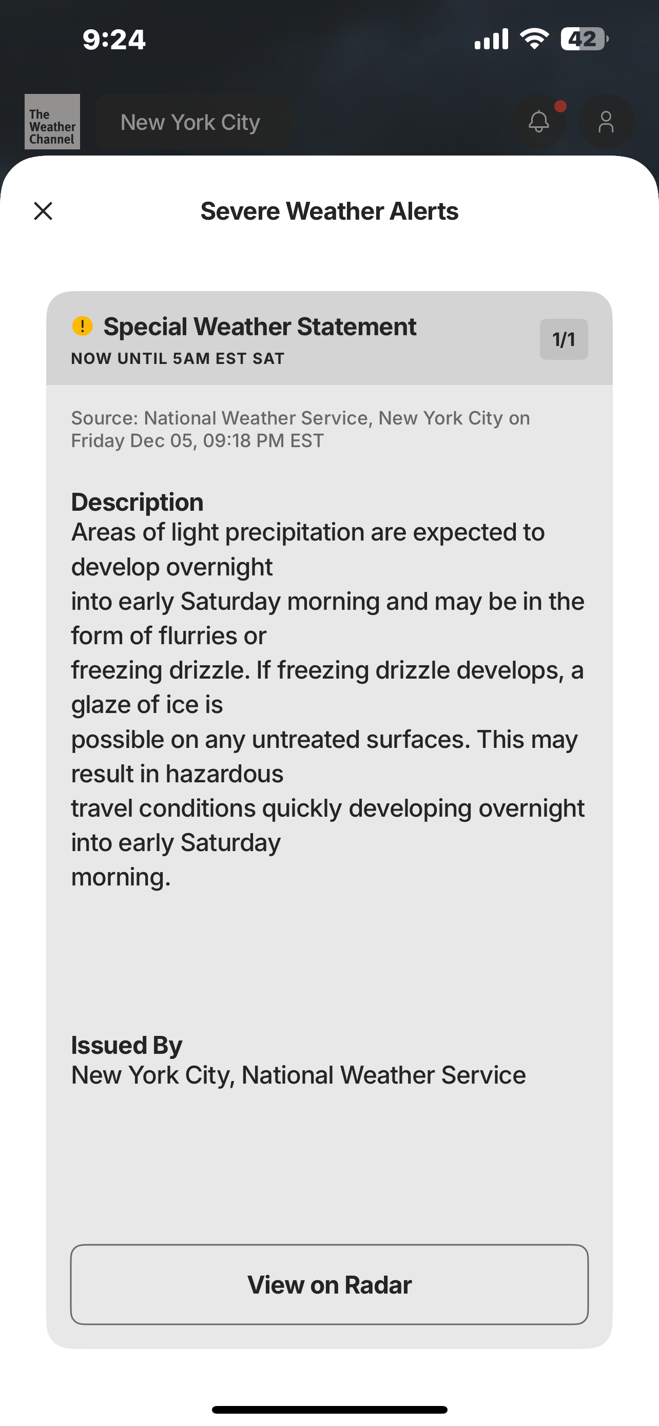
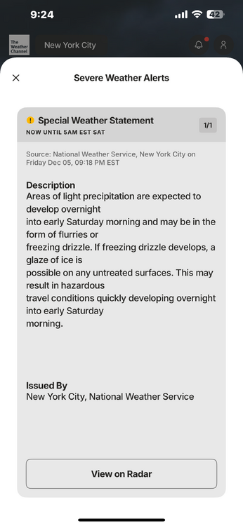
URGENT - WEATHER MESSAGE National Weather Service New York NY 845 AM EST Thu Dec 11 2025 CTZ005>012-NJZ006-NYZ071>075-078>081-176>179-112200- /O.NEW.KOKX.WI.Y.0010.251211T1345Z-251212T0900Z/ Northern Fairfield-Northern New Haven-Northern Middlesex-Northern New London-Southern Fairfield-Southern New Haven-Southern Middlesex-Southern New London-Hudson-Southern Westchester-New York (Manhattan)-Bronx-Richmond (Staten Island)-Kings (Brooklyn)- Northwest Suffolk-Northeast Suffolk-Southwest Suffolk-Southeast Suffolk-Northern Queens-Northern Nassau-Southern Queens-Southern Nassau- 845 AM EST Thu Dec 11 2025 ...WIND ADVISORY IN EFFECT UNTIL 4 AM EST FRIDAY... * WHAT...West winds 10 to 20 mph with gusts up to 50 mph. * WHERE...Portions of southern Connecticut, northeast New Jersey, and southeast New York. * WHEN...Until 4 AM EST Friday. * IMPACTS...Gusty winds will blow around unsecured objects. Tree limbs could be blown down and a few power outages may result.
-
-
Finally made it to 32 this morning for the first time this season at my station.
-
Upton AFD: LONG TERM /TUESDAY THROUGH FRIDAY/... Key Points: * Low pressure may bring the first bout of winter weather to the area Tuesday into Tuesday night. There remains uncertainty in the low track, which will be critical in determining precipitation type. At this time, it looks like mainly rain at the coast with rain/snow line somewhere over the interior. * Below normal temperatures through next Friday. NBM closely followed during this timeframe. The focus for this forecast period will remain on a potential coastal low bringing wintry weather to the region Tuesday into Tuesday night. Global models have trended farther NW with the low track the last 24h, with many of the 12Z operationals just inside the 40N...70W benchmark. The EPS/GEFS mean are farther SE, deeper, and more clustered around the mean, but there are also more members to the NW of the mean than recent days. While the Pac energy associated with this southern branch storm system is about to come onshore western Canada, there will likely be some run to run changes that are often critical to precipitation type across the area. In addition, with no blocking over the north Atlantic, high pressure quickly lifts out of the Northeast as the storm approaches, allowing for more of a marine influence and erosion of the cold air. This is why it is too difficult this far out to mention snowfall totals. What does appear to be more certain though is for a strong coastal low to impact the region. The forecast is more reflective of a consenus forecast. Such a track favors a mainly rain event at the coast, with a rain/snow line working inland. Inland locations have the best chance of seeing winter weather impacts at this time. NBM probabilities for greater than inch of snowfall range from 10-25 percent at the coast and 40- 70 percent inland. For an advisory level snow, these probabilities are 0-10 percent and 20-40 percent, respectively. High pressure will primarily in control for the second half of the week, minus a cold frontal passage on Thursday.
-
Great insight as usual Walt. NWS OKX AFD seems to be on the fence in issuing a wind advisory for Friday and does mention a slight chance of showers/flurries. I highlighted the passage to make it easier: SHORT TERM /FRIDAY THROUGH SATURDAY NIGHT/... Key Point * Friday winds gust to 40 to 45 mph, possibly higher, close to 50 mph at times. * Friday still very cold with high temperatures upper 30s to lower 40s. Max wind chills mostly in the lower 30s. The low in Quebec makes its way towards the Canadian Maritimes without much change in strength with its central low pressure on Friday. The pressure gradient during the day Friday between this low and high pressure well to the southwest becomes the most tight, indicating an even more gusty westerly flow. This will be conveyed through a deeper mixing layer and steeper lapse rates which are shown in the forecast model BUFKIT soundings. There is some indication also of some narrow sliver of elevated CAPE and with positive vorticity advection could have a few rain and/or snow showers for parts of the region. POPs are just slight chance for this. The core of the 850mb cold pool will be across the region so made some adjustments to NBM to account for this. Went higher than NBM for clouds and POPs as well as winds and lower than NBM for temperatures. NBM 90th percentile winds were used and even with these were manually adjusted up to better match up with forecast soundings from BUFKIT especially with deep vertical mixing. The current forecast has wind gust maxima of 40 to 45 mph, just below wind advisory criteria. Cannot rule out a few wind gusts to wind advisory thresholds, near 50 mph Friday. At this time, still too early and not high enough confidence to go with wind advisory for Friday but chances are slowly trending up. 06Z MAVs have trended slightly higher with sustained winds Friday afternoon for some sites compared to the 00Z MAVs. Would also like to see LAMP gusts indicate some mid to upper 30s for wind gusts to increase confidence in wind advisory for Friday. BUFKIT already indicating a few spots late afternoon into evening mix up to near 800mb with 45 kt at top of mixed layer. The 40kt wind gust potential in the HRRR fields has expanded comparing the 00Z HRRR run to the 06Z HRRR run. The wind gust potential with the 00Z run only indicated some areas of 35-40 kt wind gust potential within the region for Friday mainly in the easternmost part of LI Sound and now covers most of LI Sound and along more coastline. Forecast high temperatures Friday are mostly in the upper 30s to lower 40s with wind chills at most in the lower 30s for most locations.
-
From the NWS OKX AFD: SHORT TERM /THURSDAY THROUGH FRIDAY NIGHT/... Key points * Winds of near 20 mph with gusts near 35 to 40 mph forecast for Thanksgiving. High temperatures Thanksgiving mainly low to mid 40s but wind chills stay in the 30s. * Winds of near 25 mph with gusts near 40 to 45 mph forecast for Friday. There is still some model indication of near 50 mph wind gusts being possible. High temperatures Friday mainly in the upper 30s to lower 40s with wind chills staying mostly in the 20s to lower 30s. The key points with the short term will be gusty winds and with the higher winds, cold temperatures as well as wind chills. No measurable precipitation is expected during the timeframe of Thanksgiving through Friday night. There could be a few light rain/snow showers with strong mid level vorticity maximum pushing across on Friday. A much colder airmass will be across the region during the short term.
-
.66 total at my station.
-
.29 in the bucket at my station
-
Some of the area airports still gusting to 40mph or higher on the NWS OBS page.
-
Was just about to comment on that. Nothing from NWS?
-
Nice write up on the wind potential from OFK AFD: NEAR TERM /THROUGH TONIGHT/... ***Strong to High Winds Possible Tonight*** Deepening low pressure over the Great Lakes will track east today and pass to the north tonight, dragging a strong cold front through the area. Gusty SW winds will precede the front with the potential for gusts of 25 to 35 mph this afternoon, highest along the coast and east end of LI (40-50kt LLJ passing to the SE). A few showers will be possible along and ahead of the front this evening. CAMs show a line of convection approaching the Lower Hudson Valley around 8 pm (00Z), then dissipating as it works west to east across the area through around midnight. There is weak instability and an isolated thunderstorm is possible north and west of the NYC metro. SPC does have the Lower Hudson Valley and much of southern CT under a marginal risk, as an isolated thunderstorm could mix down some higher winds from aloft. However, the main concern is for a period of strong to possibly high post-frontal winds. The strongest winds look to be for about a 3- to 6-hour period following the cold frontal passage, from around midnight to daybreak. Latest 00Z soundings from NAM and GFS do show a period of 50-55kt winds at the top of the mixed layer during the strongest cold advection. At the same time, the nighttime hours are not as conducive to mixing due to the loss of daytime heating. NBM winds which are notoriously too weak in these situations have winds gusts below 45 mph, and even the NBM90 isn`t much higher. Neither of which support high wind warning criteria (sustained equal or greater than 40 mph and/or gusts equal or greater than 58 mph). In fact, the NBM probabilities are less than 10 percent for greater than 55 mph. Ever the HREF and global ensemble (GEFS,GEPS,and EPS) also have low probabilities. The highest probabilities are over the warmer water due to to the better mixing. Thus, have changed the high wind watch to a wind advisory for the Lower Hudson Valley, interior NE NJ, and interior SW CT. Elsewhere, the high wind watch remains in effect due to the maritime influence and warmer surface temperatures providing a deeper mixed layer. However, confidence is not high enough to go with a warning and there is time to get another look at some newer guidance before making a final decision. Either way, feel confident for gusts of 40 to 50 mph areawide.