donsutherland1
-
Posts
23,761 -
Joined
Content Type
Profiles
Blogs
Forums
American Weather
Media Demo
Store
Gallery
Everything posted by donsutherland1
-
2025-2026 ENSO
donsutherland1 replied to 40/70 Benchmark's topic in Weather Forecasting and Discussion
At least for NYC, the AO is a bigger factor. Red text=% of days e.g., AO-/NAO-; blue text: % of days in the quadrant with measurable snowfall; black text: percentage of total days with measurable snowfall. This is December-February/winter data.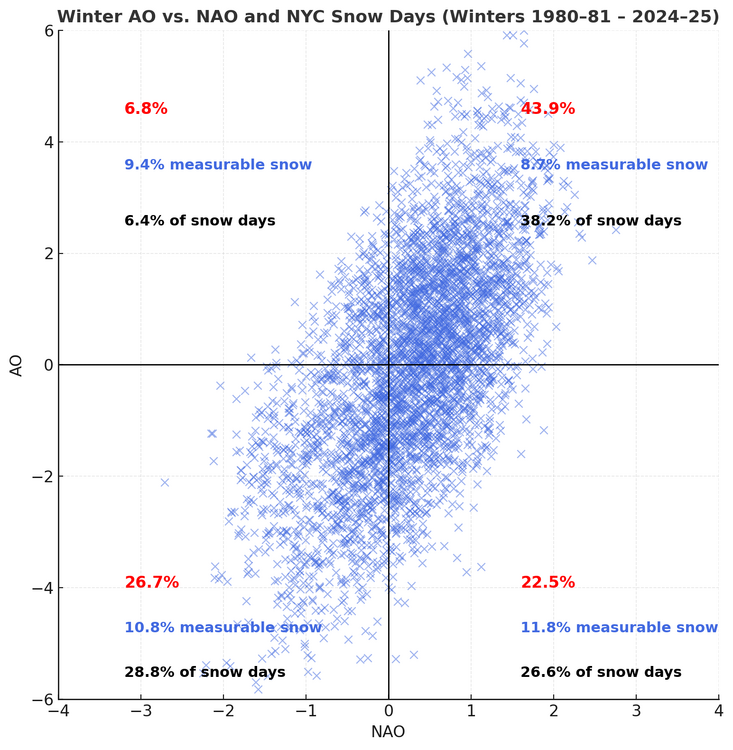
-
A fresh shot of cool air is now overspreading the region. Parts of the region could experience their coolest temperatures so far this fall tomorrow and Friday morning. Dry conditions will likely prevail through the remainder of the week. Milder air should begin to return during the weekend. In the 18 past years where Central Park saw at least two 80° or above highs and Newark saw at least two 84° or above highs during the first week of October, the temperature returned to 70° or above on at least one day during the second half of October in 17 (94.4%) of those cases. For all other cases, 84.1% saw at least one such high temperature during the second half of October. Therefore, the sharp cool spell very likely won't mean that New York City has seen its last 70° or above high temperature. The ENSO Region 1+2 anomaly was -0.1°C and the Region 3.4 anomaly was -0.3°C for the week centered around October 8. For the past six weeks, the ENSO Region 1+2 anomaly has averaged -0.12°C and the ENSO Region 3.4 anomaly has averaged -0.42°C. La Niña conditions will likely continue through mid-winter. The SOI was -3.10 today. The preliminary Arctic Oscillation (AO) was -0.731 today. Based on sensitivity analysis applied to the latest guidance, there is an implied 60% probability that New York City will have a warmer than normal October (1991-2020 normal). October will likely finish with a mean temperature near 58.7° (0.8° above normal). Supplemental Information: The projected mean would be 1.8° above the 1981-2010 normal monthly value.
-
2025-2026 ENSO
donsutherland1 replied to 40/70 Benchmark's topic in Weather Forecasting and Discussion
I agree that it was overplayed. -
2025-2026 ENSO
donsutherland1 replied to 40/70 Benchmark's topic in Weather Forecasting and Discussion
Exceptional events are low probability events. One can't continually call for low probability events and expect anything but a low probability of verification. Unfortunately, social media is populated by sites and accounts that seek clicks and attention, many of which have little or no understanding of model limitations, local/regional climatology, what is an extreme solution/outlier, the general nature of outliers, etc. That's a big problem for the weather community, as credible forecasters are drowned out by the noise and the credibility of the community is undercut when the extreme ideas typically don't verify. But, at least for now, social media is the "Wild West" of forecasting with no barriers to entry and no screening for quality. -
Occasional Thoughts on Climate Change
donsutherland1 replied to donsutherland1's topic in Climate Change
"Scary" is your description. "Sobering" is mine. But that's where the science is. On your point about verification, sea level forecasts have fared very well, so far. A paper that was published this past summer revealed: With an acceleration of global sea-level rise during the satellite altimetry era (since 1993) firmly established, it is now appropriate to examine sea-level projections made around the onset of this time period. Here we show that the mid-range projection from the Second Assessment Report of the IPCC (1995/1996) was strikingly close to what transpired over the next 30 years, with the magnitude of sea-level rise underestimated by only ∼1 cm. -
Occasional Thoughts on Climate Change
donsutherland1 replied to donsutherland1's topic in Climate Change
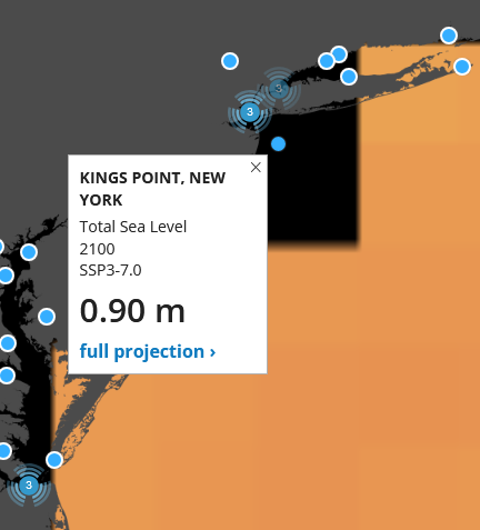
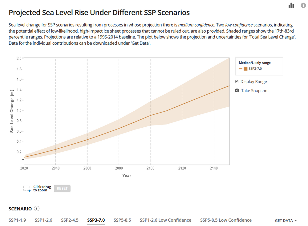
The body of science is what it is. Citing it doesn't make one an "alarmist." By the way, from the Oxford English Dictionary: And for those who are interested in sea level rise, NASA provides a great site for seeing the projections. Images for one location from one scenario: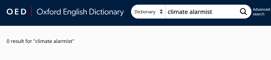
-
Occasional Thoughts on Climate Change
donsutherland1 replied to donsutherland1's topic in Climate Change
Recognizing cyclical/natural causes for climate change, alone, is insufficient. Climate change can be driven by cyclical/natural and human causes. "Climate change denial" or "climate denial" is a term that was developed to describe a position that rejects human-induced climate change. The Oxford English Dictionary defines climate denial as follows: "Rejection of the idea (or the evidence) that climate change caused by human activity is occurring, or that it represents a significant threat to human and environmental welfare." -
Occasional Thoughts on Climate Change
donsutherland1 replied to donsutherland1's topic in Climate Change
This caricature is the kind of narrative the climate change denial movement is pushing, with some success, due to the very limitations of human nature a number of us have discussed. This rhetorical move of labeling climate science as a “scary religion” and its communication as “fear mongering,” diverts attention away from measurable changes in temperature, sea level, atmospheric composition, and the role of human-induced greenhouse gas pollution in driving those changes. It reframes the issue as a matter of emotion or ideology, not science. By characterizing concern about climate change as exaggerated and predictions as “crying wolf,” it normalizes passivity and delays collective response. The premise of its strategy is to convince the public that the threat of climate change is overblown, if it exists at all. After all, if a threat is overblown or non-existent, then no change is necessary. Put another way, humanity can continue, even expand, its ongoing greenhouse gas-driven geoengineering project. Yet, sea level rise is not imaginary. Sea level rise is real. The notion that a reduction in the Greenland and Antarctic ice sheets will result in no sea level rise whatsoever is fiction. The description of what sea level rise might look like can call attention to what will become a big problem in the future. Further, sea level rise and human futility in holding it back is not without historical precedent. Along the ancient seafront of Delos, generations of builders struggled to hold back the advancing sea. Beginning in the Classical era, they constructed an immense granite breakwater to protect the harbor from waves and erosion. Over the centuries, as the shoreline crept inland, new defenses were added: rockfills, seawalls, and massive boulders aligned along the coast. Each layer of construction, which now lies at depths of 3 to 4 meters below the modern sea, marks an episode of retreat and rebuilding, a record of determination in the face of encroaching waters. Roads and docks that once thrived with merchants and pilgrims were gradually overtaken by the rising tide. Today, the remains of these ancient defenses lie submerged beneath the Aegean Sea, preserved in successive bands of beachrock. Divers can trace their contours like pages in a drowned chronicle that bears the testimony to centuries of futile struggle against a force that could not be contained. The harborworks of Delos, once symbols of resilience and prosperity, now rest silent beneath the waves, their stones bearing witness to the city’s slow surrender to the rise of the sea. Doggerland, which now lies beneath the waters of the North Sea, provides another example of land that was reclaimed by a rising sea. Climate science has done its part. No one can even plausibly argue that "they didn't know," much less claim that the events projected by the science (more frequent heatwaves, more intense precipitation events, melting glaciers/ice sheets, rising sea levels) were matters beyond human control. Those outcomes will be a matter of choice, namely the choice to set aside the laws of physics, to continue to inject vast sums of CO2 into the atmosphere. -
Occasional Thoughts on Climate Change
donsutherland1 replied to donsutherland1's topic in Climate Change
I think you sum things up quite well when you observe, "We ARE in a catastrophe, a slow moving one. Too slow to be seen in what we call 'real time', or human perception, but that slowness only beguiles us into a false sense of lessening urgency." The dismissive reply, “Sky is falling, sky is falling... no one believes our cyclical climate change is an issue anymore,” underscores the profound limits of human perception. Bound by the narrow window of our senses, humanity struggles to grasp processes that unfold across geological time. The fact that atmospheric CO₂ is rising at a rate an order of magnitude faster than during the Paleocene–Eocene Thermal Maximum defies societal comprehension. Likewise, the speed and scale of modern warming — occurring over mere decades — eclipses even the most abrupt natural transitions of the past. Science, meanwhile, becomes abstracted: detached from daily life and stripped of moral urgency, reduced to statistics that fail to move those in power. One can imagine a future, perhaps later this century or the next , unfolding not unlike this: Along the crumbling coast of a small seaside town, the waves crept higher each year. First they lapped at the boardwalk, then at the porches of modest homes, and finally, with one furious storm, they tore entire houses into the sea. Families watched helplessly as their memories — photographs, heirlooms, childhood bedrooms — vanished beneath the rising tide’s insatiable pull. Erosion devoured the land faster than insurance adjusters could arrive. Those who stayed were left standing on smaller and smaller fragments of earth, surviving on borrowed time. Eventually, the ocean reclaimed even those last fragile remnants. When the survivors turned to their government and neighbors for help, the answer was chillingly simple: “You should have protected your property. It’s your problem, not ours.” The same indifference that once ignored melting glaciers now ignored the people who had lost everything. The moral is stark: indifference to climate change protects no one. It merely ensures that the destruction will spread. Some of this future has already arrived. Insurers are withdrawing from entire regions. Empathy is receding just as the waters advance. Even on today’s smaller scales, societal compassion erodes as swiftly as the land itself. One sees the draining empathy in rising Nativism in various parts of the world, including but not limited to the United States, which is a symptom a broader and deepening societal sickness. In the U.S., that societal infection is being compounded by a growing rejection of science. Sustainability breaks down when the rate of change exceeds the rate at which society, ecosystems, and organisms can adapt to that change. When the gulf between nonlinear environmental upheaval and our linear, incremental responses becomes too vast, a system reaches its inflection point. It breaks or finds a new stable regime, that is not necessarily compatible with human welfare. The tragedy of climate change is not merely the loss of stability. It is the squandering of agency. Humanity still possesses the ability to act, though less effectively than if it had done so earlier. Humanity can still limit the damage e.g., perhaps to 3°C by 2100 rather than 1.5°C, assuming no big positive feedbacks. But bound by the limits of human nature, weak leadership, and an economic model that treats a finite planet as an infinite resource to be exploited, humanity continues to squander its narrowing window. Catastrophe is not sudden. It is cumulative. Arguably, humanity is already in the midst of the early days of rising catastrophe. -
2025-2026 ENSO
donsutherland1 replied to 40/70 Benchmark's topic in Weather Forecasting and Discussion
Neutral-cool winters offer a mixed picture. There have been some good ones, one great one (the highly popular 2013-14), one horrible one, since 1980. 1980-81, 1981-82, 1989-1990, 2001-02, 2012-13, 2013-14, and 2016-17. By late fall, there could be stronger hints. The coefficient of determination for the WPO begins to ramp up in November. A predominantly negative WPO is a good sign for the winter; a predominantly positive one is not. Finally, based on subsequent research, the rapid buildup of snow cover in Siberia is not a good thing, if one is looking for a lot of Atlantic blocking. This research has suggested that a higher Siberian Snow Advance Index (SAI) is correlated with a positive AO. It also notes that the early inverse relationship found by Cohen et al., was an exception, not a rule. Excerpts: The running decadal correlations between the SAI_OCT and AO and SAI_NOV and AO are shown in Fig. 7d and e, respectively. In the former, there are significantly more positive than negative values (Table 3), suggesting that the period of strong positive (negative as defined here) correlations that occurred in the 1990s and 2000s, as described by Cohen and Jones (2011), was a rather exceptional event, as previously noted by Peings et al. (2013). Indeed, the frequency of decades with significant SCA_OCT–AO correlations of either sign are not significant. In addition to the recent period in the 2000s, Fig. 7d reveals a period of significant negative correlations centred in the 1840s, also present in the 21-year data (Fig. S4d). Finally, the ERA5 data reveal that the recent period of the statistically significant negative relationship between SAI_OCT and the AO has ended: the most recent decades have positive r values. -
Occasional Thoughts on Climate Change
donsutherland1 replied to donsutherland1's topic in Climate Change
I strongly agree. Data adjustment is essential, because without accounting for station moves, observer/observation changes, and changing local environments e.g., urbanization, the record would reflect human and site variability rather than true climate trends. The Coatesville 1SW example clearly demonstrates why homogenization techniques are both necessary and effective. -
Occasional Thoughts on Climate Change
donsutherland1 replied to donsutherland1's topic in Climate Change
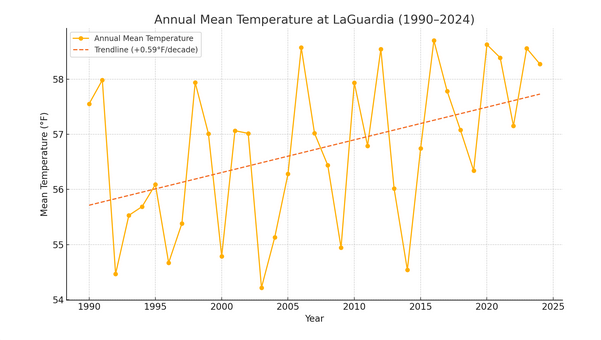
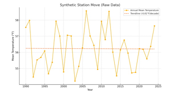
If one is looking for a reliable climate record, adjustments are necessary whenever a station moves. Here's an illustration. Envision a case where one is measuring the temperature in Queens, NY. Assume that the climate record starts in 1990 for purposes of illustration. Temperatures are taken at LaGuardia Airport through 2014. After that, the Queens station moves to JFK Airport. Temperatures are then recorded at JFK Airport through 2024 for purposes of this illustration. If one relied only on raw, unadjusted data, here's what the Queens climate record would look like: There would essentially be no trend in temperatures. Those arguing for the use of unadjusted data would argue that warming is an artifact of statistical adjustments. But here's what things would actually look like: JFK: LaGuardia: The graphs reveal a clear discontinuity in the temperature record when switching from LaGuardia Airport (1990–2014) to JFK Airport (2015–2024), even though they are only 10.9 miles apart. The resulting trend is artificially altered by the change in station location, not by climate. In fact, both stations were warming at similar rates. This simple illustration demonstrates that without adjusting for such moves, the integrity of the climate record ceases to exist. The synthetic station trend is lower than either station individually. In other words, threading the raw data to maintain a continuous climate record creates a badly biased outcome. In sum, station moves introduce biases. To maintain an accurate climate record, data must be homogenized. The data must be corrected for site changes, if one wants an accurate climate signal.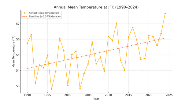
-
Tomorrow will be partly sunny and milder with highs reaching the middle 60s. However, a fresh shot of cool air will move into the region late in the day or at night. Following the frontal passage, parts of the region could experience their coolest temperatures so far this fall. Dry conditions will likely prevail through the remainder of the week. In the 18 past years where Central Park saw at least two 80° or above highs and Newark saw at least two 84° or above highs during the first week of October, the temperature returned to 70° or above on at least one day during the second half of October in 17 (94.4%) of those cases. For all other cases, 84.1% saw at least one such high temperature during the second half of October. Therefore, the sharp cool spell very likely won't mean that New York City has seen its last 70° or above high temperature. The ENSO Region 1+2 anomaly was -0.1°C and the Region 3.4 anomaly was -0.3°C for the week centered around October 8. For the past six weeks, the ENSO Region 1+2 anomaly has averaged -0.12°C and the ENSO Region 3.4 anomaly has averaged -0.42°C. La Niña conditions will likely continue through mid-winter. The SOI was -3.48 today. The preliminary Arctic Oscillation (AO) was -0.487 today. Based on sensitivity analysis applied to the latest guidance, there is an implied 66% probability that New York City will have a warmer than normal October (1991-2020 normal). October will likely finish with a mean temperature near 58.9° (1.0° above normal). Supplemental Information: The projected mean would be 2.0° above the 1981-2010 normal monthly value.
-
Three-day rainfall totals for the New York City area:
- 731 replies
-
- 3
-

-
- heavy rain
- damaging wind
- (and 2 more)
-
Probably less than that in most places, but a few areas could still see another 0.25". Favored areas for the heavier amounts are on Long Island.
- 731 replies
-
- 1
-
-
- heavy rain
- damaging wind
- (and 2 more)
-
The nor'easter that brought heavy rainfall to the coastal plain is now poised to pull away. Some additional showers, periods of rain, and drizzle are likely overnight. Following the nor'easter, tomorrow will be mostly cloudy and mild. Clouds could break from west to east during the afternoon. Temperatures will top out in the lower 60s in many parts of the region. Wednesday will be partly sunny and milder with highs reaching the middle 60s. However, a fresh shot of cool air will move into the region late Wednesday or Wednesday night. Following the frontal passage, parts of the region could experience their coolest temperatures so far this fall. Dry conditions will likely prevail through the remainder of the week. In the 18 past years where Central Park saw at least two 80° or above highs and Newark saw at least two 84° or above highs during the first week of October, the temperature returned to 70° or above on at least one day during the second half of October in 17 (94.4%) of those cases. For all other cases, 84.1% saw at least one such high temperature during the second half of October. Therefore, the sharp cool spell very likely won't mean that New York City has seen its last 70° or above high temperature. The ENSO Region 1+2 anomaly was -0.1°C and the Region 3.4 anomaly was -0.3°C for the week centered around October 8. For the past six weeks, the ENSO Region 1+2 anomaly has averaged -0.12°C and the ENSO Region 3.4 anomaly has averaged -0.42°C. La Niña conditions will likely continue through mid-winter. The SOI was +7.15 today. The preliminary Arctic Oscillation (AO) was -0.345 today. Based on sensitivity analysis applied to the latest guidance, there is an implied 63% probability that New York City will have a warmer than normal October (1991-2020 normal). October will likely finish with a mean temperature near 58.8° (0.9° above normal). Supplemental Information: The projected mean would be 1.9° above the 1981-2010 normal monthly value.
-
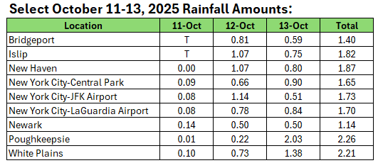
Select rainfall amounts through 6 pm: Daily Record for October 13: Poughkeepsie: 1.89" (old record: 1.25", 2005)
- 731 replies
-
- 1
-
-
- heavy rain
- damaging wind
- (and 2 more)
-
2025-2026 ENSO
donsutherland1 replied to 40/70 Benchmark's topic in Weather Forecasting and Discussion
One doesn't need to include 2013-2014 to get some sustained periods of high latitude blocking, particularly in the EPO domain. If, and it remains conditional, 2013 falls apart in its ability to predict the fall pattern evolution, it's tough to argue that it should be retained. None of the cases, including the emerging 2021-2022 case, is perfect. But their ability to retain predictive value heading toward winter matters. For now, there is no strong evidence for a "blow torch" winter in the Northeast or Great Lakes Region. Snowfall looks better than in recent winters e.g., I posted an initial guess of 15"-25" for NYC in the NYC forum (Boston looks even better, though not a blockbuster).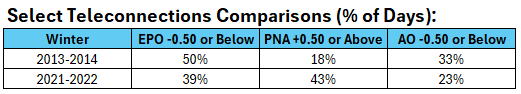
-
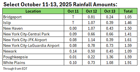
Through 9 am, rainfall amounts have been pretty much in line with expectations for the ongoing event.
- 731 replies
-
- 1
-
-
- heavy rain
- damaging wind
- (and 2 more)
-
2025-2026 ENSO
donsutherland1 replied to 40/70 Benchmark's topic in Weather Forecasting and Discussion
I agree. That it misses on some other key variables i.e., IOD, QBO, etc., leads me to rank it lower, excluding the SSTs. It's still in the larger mix. I'll re-examine the SSTAs later this month. The October outcome could provide a powerful clue. The 2013 500 mb outcome diverges from the last monthly ECMWF forecast for October. If the ECMWF forecast is reasonably accurate, that will indicate that the 2013 scenario is off track. And if the "Blob" continues to dissipate, that would be a further signal. -
2025-2026 ENSO
donsutherland1 replied to 40/70 Benchmark's topic in Weather Forecasting and Discussion
It's too soon to tell. Last winter's miss was unusually large. One can probably use a +/- 1°C range to consider reasonable possibilities. -
2025-2026 ENSO
donsutherland1 replied to 40/70 Benchmark's topic in Weather Forecasting and Discussion
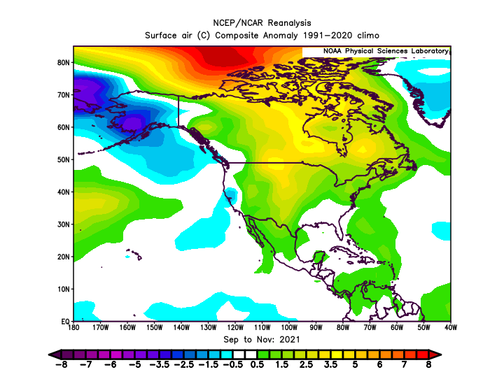
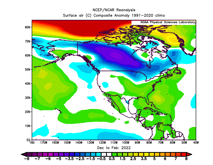
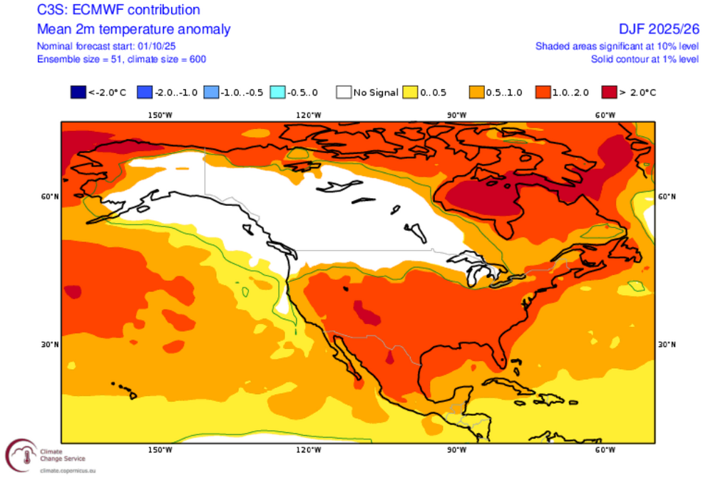
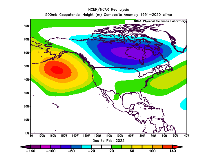
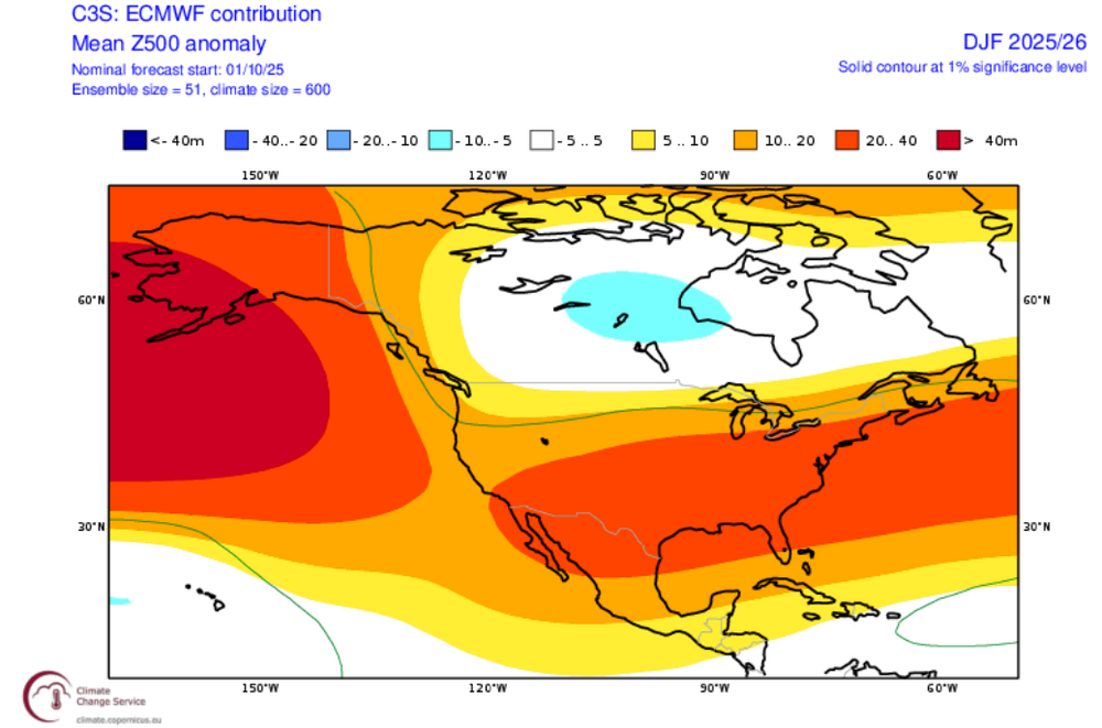
To date, among the emerging cases that could provide insight into Winter 2025-2026 temperatures is 2021 (ENSO, RONI, QBO, IOD, and PDO). Consistent with the lack of statistical relationship between ACE and winter temperatures/snowfall, ACE isn't considered. Solar flux is also a mismatch (suggesting perhaps a milder version of 2021-2022), but for now this is an emerging case. The evolution of the North Pacific SSTAs and continuing evolution of ENSO will be important factors. Here's the fall 2025 outlook using 2021: Fall 2025 (through October 10): Winter 2025-2026 using 2021-2022: ECMWF DJF Forecast:
-
Mountain West Discussion
donsutherland1 replied to mayjawintastawm's topic in Central/Western States
Just in time for Thanksgiving Day. Have a great Thanksgiving Day, tomorrow. -
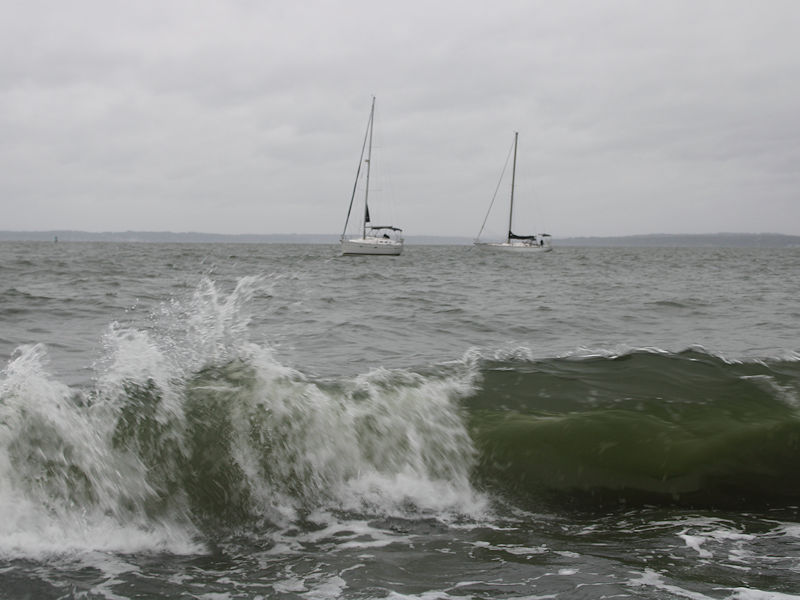
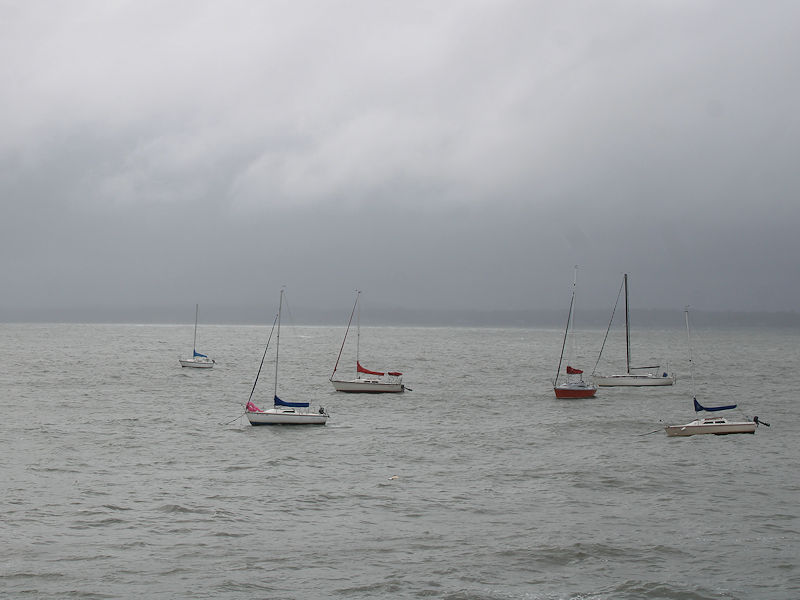
Two photos from late this afternoon from the Long Island Sound: