donsutherland1
-
Posts
23,719 -
Joined
Content Type
Profiles
Blogs
Forums
American Weather
Media Demo
Store
Gallery
Everything posted by donsutherland1
-
Morning thoughts… Today will be partly sunny and pleasant. High temperatures will likely reach the middle and upper 70s with a few lower 80s in most of the region. Likely high temperatures around the region include: New York City (Central Park): 77° Newark: 81° Philadelphia: 81° Normals: New York City: 30-Year: 75.1°; 15-Year: 76.1° Newark: 30-Year: 76.6°; 15-Year: 77.7° Philadelphia: 30-Year: 77.9°; 15-Year: 78.7° A moderate to perhaps significant rainfall is possible during the middle or latter part of the week.
-
Occasional Thoughts on Climate Change
donsutherland1 replied to donsutherland1's topic in Climate Change
One isn’t dealing with trivial amounts of oil and gas, and therefore future greenhouse gas emissions. From the BOEM: The Bureau of Ocean Energy Management (BOEM) proposes to offer approximately 78.2 million acres for a region-wide Gulf of Mexico lease sale scheduled for March 2021. Lease Sale 257, scheduled to be livestreamed from New Orleans, will be the eighth offshore sale under the 2017-2022 Outer Continental Shelf Oil and Gas Leasing Program. The sale will include approximately 14,594 unleased blocks – all of the available unleased areas in federal waters of the Gulf of Mexico... The Gulf of Mexico Outer Continental Shelf (OCS), covering about 160 million acres, is estimated to contain about 48 billion barrels of undiscovered technically recoverable oil and 141 trillion cubic feet of undiscovered technically recoverable gas. https://www.boem.gov/boem-proposes-first-gulf-oil-and-gas-lease-sale-2021 Nearly 49% of an area with enormous fossil fuel reserves is very substantial. This is why climate scientists, environmentalists, and members of the public who want to address climate change are objecting. Geopolitically, a country that is expanding its own fossil fuel footprint lacks the standing to tell others, including India and China, to do more, even as more is urgently needed if the 1.5C or 2.0C goals are to be met. All in all, it provides a damaging example. -
Occasional Thoughts on Climate Change
donsutherland1 replied to donsutherland1's topic in Climate Change
The reason why expansion of fossil fuel infrastructure despite promises of addressing climate change needs to be called out:
-
The last weekend of astronomical summer began with temperatures reaching the middle and upper 80s across the New York City region. Tomorrow will be fair and somewhat cooler. The potential exists for a moderate to perhaps significant rainfall during the middle or latter part of next week. Readings will mainly be in the 70s during the day and upper 50s and lower 60s at night. The recent guidance has taken a dramatic turn away from a warm close to September. Instead, early indications of a trough and cooler than normal readings have grown in magnitude. If the guidance holds up, it is close to a toss-up whether 2021 will become the 6th out of the last 7 years during which September has had a mean temperature of 70° or above in New York City. Considering that the close of September is still more than 10 days out, the guidance can still reverse. Prior to 2000, New York City saw such warmth on average once every five years. In short, September has become more an extension of summer than a gateway to autumn in the New York City area. Fall 2021 will likely be wetter to much wetter than normal in the northern Middle Atlantic region. Since 1869, there have been 9 August cases where New York City picked up 20.00" or more rainfall during the summer. Two thirds of those cases (and 4/5 of those with summer mean temperatures of 73.0° or above) had 17.00" or more fall precipitation in New York City. 2011 is probably the closest match in terms of precipitation and a nearly identical summer mean temperature. Mean fall precipitation for those 9 cases was 14.86". The median was 17.35". The 1991-2020 normal value is 12.27". The ENSO Region 1+2 anomaly was -0.2°C and the Region 3.4 anomaly was -0.3°C for the week centered around September 8. For the past six weeks, the ENSO Region 1+2 anomaly has averaged +0.22°C and the ENSO Region 3.4 anomaly has averaged -0.43°C. Neutral ENSO conditions will likely prevail through September. Afterward, La Niña conditions could begin to develop. The SOI was +14.20 today. The preliminary Arctic Oscillation (AO) figure was +0.354 today. On September 16 the MJO was in Phase 3 at an amplitude of 1.826 (RMM). The September 15-adjusted amplitude was 1.851 (RMM). Based on sensitivity analysis applied to the latest guidance, there is an implied 64% probability that New York City will have a warmer than normal September (1991-2020 normal). September will likely finish with a mean temperature near 70.2° (1.0° above normal).
-
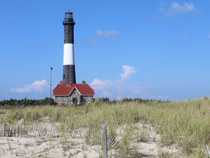
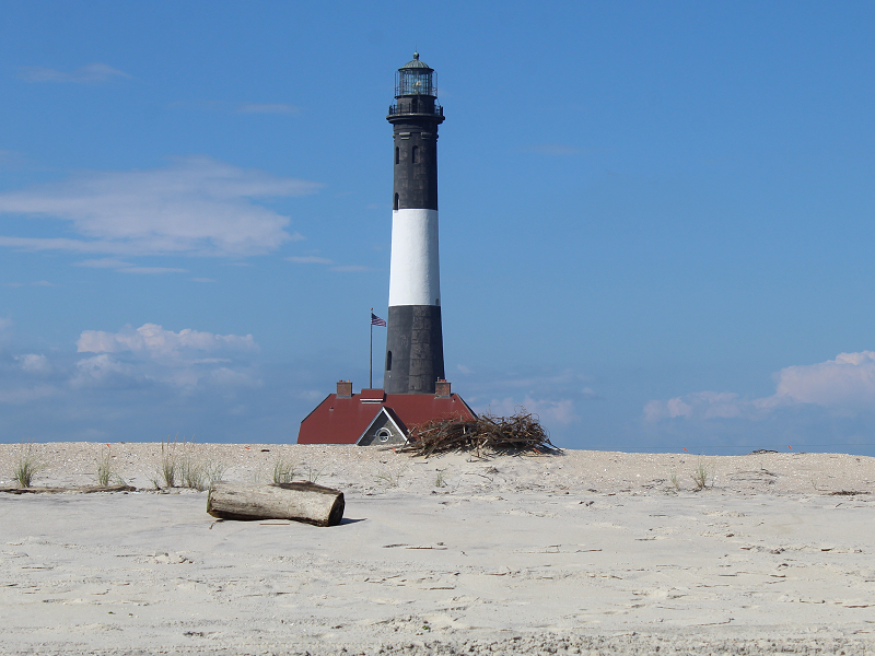
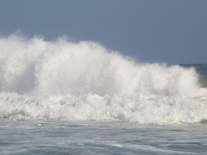
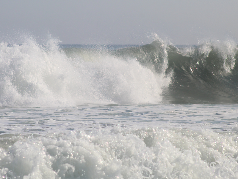
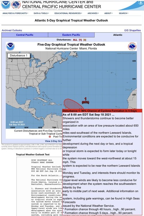
Bright sunshine was present at Robert Moses State Park. The waves were higher than usual on account of Odette, which is far offshore.
-
Occasional Thoughts on Climate Change
donsutherland1 replied to donsutherland1's topic in Climate Change
My guess is that with some exceptions, human society has an almost iron-clad commitment to the status quo, even one that is unsustainable, because it has fear of change that exceeds fear of the consequences of inaction. Thus, there is a bias for inaction and rhetoric outruns substantive action. Denial of the reality that a status quo can’t be preserved is explicit (denial of climate change) or implicit (belief that one can finance and approve expanded fossil fuel production and magically make progress toward net zero emissions). Far more effort and investment are devoted to saving the status quo than toward an early transition during which time is sufficient to avert significant disruption or avoid the much higher cost from allowing things to worsen. The leadership and action undertaken to address the ozone hole and acid rain are exceptions to the rule. My concern is that the disasters of this summer will be largely forgotten in the policy and business world. In terms of concrete policy and energy production, things will go on little changed. The gap between rhetoric and action will continue to widen. That gap will only be resolved when a crisis of a much larger magnitude imposes a new order. Then, of course, the shift will be more disruptive and the economic and human costs much higher than would otherwise have been the case. There are plausible candidates for such crises, but they still lie in the future. One would entail a series of years where widespread crop failures lead to an appreciable shortage of food. Another would entail a massive marine heatwave that results in an appreciable decline in the population of sea life, including seafood. Still another would entail reaching an irreversible tipping point that dooms the Greenland ice sheet and a significant part of the Antarctic ice sheet, and subsequently, much of the world’s coastlines and coastal cities to the rising sea. I don’t currently think humanity will get that far, but am concerned that humanity will approach such a situation due to insufficient policy measures. Unfortunately, because humans aren’t prescient, it will be uncertain precisely where the boundary that separates a severe crisis from a truly catastrophic one lies. With continued delay, there will be danger that humanity could wait too long to avert the latter. -
Perhaps the last chance? But not my preference.
-
Morning thoughts… Today will be partly sunny and warm. High temperatures will likely reach the lower and middle 80s in most of the region. Likely high temperatures around the region include: New York City (Central Park): 82° Newark: 87° Philadelphia: 86° Normals: New York City: 30-Year: 75.5°; 15-Year: 76.4° Newark: 30-Year: 77.0°; 15-Year: 78.0° Philadelphia: 30-Year: 78.2°; 15-Year: 79.1° Tomorrow will be partly sunny and cooler.
-
Occasional Thoughts on Climate Change
donsutherland1 replied to donsutherland1's topic in Climate Change
My concern is that she is merely carrying out the Administration’s policy. That policy is inconsistent with its rhetoric and even more inconsistent with what’s needed to begin to address climate change. -
Occasional Thoughts on Climate Change
donsutherland1 replied to donsutherland1's topic in Climate Change
It’s from the Bureau of Ocean Energy Management (part of the Department of Interior). -
Larry almost certainly enhanced the blocking. But at this time of year, long-range modeling can change dramatically.
-
Occasional Thoughts on Climate Change
donsutherland1 replied to donsutherland1's topic in Climate Change
A new document concerning oil and gas lease sale 257 is just the latest evidence that the tyranny of the status quo in favor of fossil fuels still prevails in Washington, D.C.. Page 7 declares that the recent IPCC report “does not present sufficient cause” to block the sale of new oil and gas leases. The IPCC had declared, “It is unequivocal that human influence has warmed the atmosphere, ocean and land. Widespread and rapid changes in the atmosphere, ocean, cryosphere and biosphere have occurred.” Unfortunately, despite all its bold talk, “unequivocal” evidence is insufficient cause for this Administration to suspend the expansion of the nation’s fossil fuel footprint. Something close to business-as-usual is its energy policy business. And, in the best tradition of punting concrete action into the future while seeking credit for that punt, the document suggests, that the report and “additional analysis of climate change may be a significant consideration” in the future. No credit is merited. Instead, the Administration will have steepened the slope for achieving net zero emissions by 2050. Given this pathetic embrace of fossil fuel expansion, it is becoming increasingly likely that the United States will come to the COP26 conference without something big and concrete like a clean electricity standard. Instead it may well make promises that are short of concrete policy outcomes. There will be no enforcement mechanisms. And the actual actions will be left to the future. Again. Other countries will take note. The U.S. Republican Party and pro-fossil fuel Democrats such as Joe Mancin will be emboldened. U.S. policy action will fizzle. Another opportunity to finally begin to tackle climate change will be squandered. Another generation of political leaders will bequeath the growing mess of climate change to the nation’s youth—youth who made the current Administration’s victory possible in the first place. Being marginally better than the historically bad Trump Administration is of little consolation. Much more needs to be done over an increasingly short and shortening timeframe. Will the President intervene to overturn this decision to increase the nation’s greenhouse gas emissions? In other words, will he provide leadership or leadership failure. Well, for an Administration that asked OPEC to increase oil production just after the IPCC released its report, the odds seem against such action. I hope my worries are misplaced. Whether the U.S. announces concrete, binding policies or merely offers promises at COP26 will be revealing. -
Tomorrow will be partly sunny and warmer. Readings will likely reach the lower and middle 80s across much of the region. However the warmth will likely be fairly short-lived. Overnight, the guidance has taken a dramatic turn away from a warm close to September. Instead, early indications of a trough and cooler than normal readings have grown in magnitude. If the guidance holds up, it is close to a toss-up whether 2021 will become the 6th out of the last 7 years during which September has had a mean temperature of 70° or above in New York City. Considering that the close of September is still more than 10 days out, the guidance can still reverse. Prior to 2000, New York City saw such warmth on average once every five years. In short, September has become more an extension of summer than a gateway to autumn in the New York City area. Fall 2021 will likely be wetter to much wetter than normal in the northern Middle Atlantic region. Since 1869, there have been 9 August cases where New York City picked up 20.00" or more rainfall during the summer. Two thirds of those cases (and 4/5 of those with summer mean temperatures of 73.0° or above) had 17.00" or more fall precipitation in New York City. 2011 is probably the closest match in terms of precipitation and a nearly identical summer mean temperature. Mean fall precipitation for those 9 cases was 14.86". The median was 17.35". The 1991-2020 normal value is 12.27". The ENSO Region 1+2 anomaly was -0.2°C and the Region 3.4 anomaly was -0.3°C for the week centered around September 8. For the past six weeks, the ENSO Region 1+2 anomaly has averaged +0.22°C and the ENSO Region 3.4 anomaly has averaged -0.43°C. Neutral ENSO conditions will likely prevail through September. Afterward, La Niña conditions could begin to develop. The SOI was +14.50 today. The preliminary Arctic Oscillation (AO) figure was +0.279 today. On September 15 the MJO was in Phase 3 at an amplitude of 1.852 (RMM). The September 14-adjusted amplitude was 2.022 (RMM). Based on sensitivity analysis applied to the latest guidance, there is an implied 60% probability that New York City will have a warmer than normal September (1991-2020 normal). September will likely finish with a mean temperature near 70.4° (1.2° above normal).
-
Arctic Sea Ice Extent, Area, and Volume
donsutherland1 replied to ORH_wxman's topic in Climate Change
Thanks. It still missed badly on NSIDC both last year and this year. -
Morning thoughts… Today will be partly to mostly cloudy and still cool. Some widely scattered showers are possible. Most of the region will see no measurable rainfall. High temperatures will likely reach the middle and upper 70s in most of the region. Likely high temperatures around the region include: New York City (Central Park): 75° Newark: 79° Philadelphia: 80° Normals: New York City: 30-Year: 75.9°; 15-Year: 76.7° Newark: 30-Year: 77.4°; 15-Year: 78.3° Philadelphia: 30-Year: 78.6°; 15-Year: 79.4° Tomorrow will be partly sunny and warmer.
-
The frontal system that produced scattered showers and thundershowers yesterday and today will move back toward the region tomorrow. As a result, some additional showers are likely. A warm September outcome remains on track. Despite a cooler than normal first 7-10 days (for example, the 9/1-7 anomaly was -2.5° in New York City and the 9/1-10 anomaly was -1.6° in New York City), September will likely feature near normal to somewhat warmer than normal temperatures in much of the region. The second half of the month could feature above to perhaps much above normal temperatures. As a result, 2021 is increasingly likely to become the 6th out of the last 7 years during which September has had a mean temperature of 70° or above in New York City. Prior to 2000, New York City saw such warmth on average once every five years. In short, September has become more an extension of summer than a gateway to autumn in the New York City area. Fall 2021 will likely be wetter to much wetter than normal in the northern Middle Atlantic region. Since 1869, there have been 9 August cases where New York City picked up 20.00" or more rainfall during the summer. Two thirds of those cases (and 4/5 of those with summer mean temperatures of 73.0° or above) had 17.00" or more fall precipitation in New York City. 2011 is probably the closest match in terms of precipitation and a nearly identical summer mean temperature. Mean fall precipitation for those 9 cases was 14.86". The median was 17.35". The 1991-2020 normal value is 12.27". The ENSO Region 1+2 anomaly was -0.2°C and the Region 3.4 anomaly was -0.3°C for the week centered around September 8. For the past six weeks, the ENSO Region 1+2 anomaly has averaged +0.22°C and the ENSO Region 3.4 anomaly has averaged -0.43°C. Neutral ENSO conditions will likely prevail through September. Afterward, La Niña conditions could begin to develop. The SOI was +9.75 today. The preliminary Arctic Oscillation (AO) figure was +0.131 today. On September 14 the MJO was in Phase 3 at an amplitude of 2.022 (RMM). The September 13-adjusted amplitude was 1.897 (RMM). Based on sensitivity analysis applied to the latest guidance, there is an implied 71% probability that New York City will have a warmer than normal September (1991-2020 normal). September will likely finish with a mean temperature near 70.8° (1.6° above normal).
-
Arctic Sea Ice Extent, Area, and Volume
donsutherland1 replied to ORH_wxman's topic in Climate Change
Just as had been the case last year, the Slater model performed horribly. Had one taken the mean 2010-2020 decline from the date the model forecast was generated, one would have had a vastly better idea of minimum extent. That figure was 4.4 million square kilometers (JAXA). The SIA had an implied minimum of 5.15 million square kilometers. Now that Arctic sea ice extent has increased for 3 consecutive days, it is likely that the 9/12 figure of 4,612,915 square kilometers will be the 2021 minimum. That will be the highest minimum extent since 2014 when the minimum extent was 4,884,120 square kilometers. The last figure at or above 5 million square kilometers was more than a decade ago in 2009. -
Morning thoughts… Today will be mostly cloudy and cooler. Showers and perhaps thundershowers are possible in some areas. High temperatures will likely reach the middle and upper 70s in most of the region. Likely high temperatures around the region include: New York City (Central Park): 75° Newark: 79° Philadelphia: 80° Normals: New York City: 30-Year: 76.3°; 15-Year: 77.1° Newark: 30-Year: 77.8°; 15-Year: 78.6° Philadelphia: 30-Year: 79.0°; 15-Year: 79.7° Tomorrow will be partly to mostly cloudy.
-
A cold front will cross the region tonight with some showers and thundershowers. Its progression will slow resulting in a partly to mostly cloudy and cooler day tomorrow. Additional showers are possible in parts of the region. A warm September outcome remains on track. Despite a cooler than normal first 7-10 days (for example, the 9/1-7 anomaly was -2.5° in New York City and the 9/1-10 anomaly was -1.6° in New York City), September will likely feature near normal to somewhat warmer than normal temperatures in much of the region. The second half of the month could feature above to perhaps much above normal temperatures. As a result, 2021 is increasingly likely to become the 6th out of the last 7 years during which September has had a mean temperature of 70° or above in New York City. Prior to 2000, New York City saw such warmth on average once every five years. In short, September has become more an extension of summer than a gateway to autumn in the New York City area. Fall 2021 will likely be wetter to much wetter than normal in the northern Middle Atlantic region. Since 1869, there have been 9 August cases where New York City picked up 20.00" or more rainfall during the summer. Two thirds of those cases (and 4/5 of those with summer mean temperatures of 73.0° or above) had 17.00" or more fall precipitation in New York City. 2011 is probably the closest match in terms of precipitation and a nearly identical summer mean temperature. Mean fall precipitation for those 9 cases was 14.86". The median was 17.35". The 1991-2020 normal value is 12.27". The ENSO Region 1+2 anomaly was -0.2°C and the Region 3.4 anomaly was -0.3°C for the week centered around September 8. For the past six weeks, the ENSO Region 1+2 anomaly has averaged +0.22°C and the ENSO Region 3.4 anomaly has averaged -0.43°C. Neutral ENSO conditions will likely prevail through September. Afterward, La Niña conditions could begin to develop. The SOI was +10.34 today. The preliminary Arctic Oscillation (AO) figure was +0.141 today. On September 13 the MJO was in Phase 3 at an amplitude of 1.898 (RMM). The September 12-adjusted amplitude was 1.603 (RMM). Based on sensitivity analysis applied to the latest guidance, there is an implied 76% probability that New York City will have a warmer than normal September (1991-2020 normal). September will likely finish with a mean temperature near 71.0° (1.8° above normal).
-
Accidentally posted in the climate change forum (when did the definition of climate change so drastically that this was there?): Morning thoughts… Today will be partly sunny and very warm. High temperatures will likely reach the middle and upper 80s in most of the region. An approaching cold front could trigger some late day or evening showers or thunderstorms. Likely high temperatures around the region include: New York City (Central Park): 85° Newark: 89° Philadelphia: 89° Normals: New York City: 30-Year: 76.6°; 15-Year: 77.1° Newark: 30-Year: 78.1°; 15-Year: 78.9° Philadelphia: 30-Year: 79.3°; 15-Year: 80.0° Tomorrow will be mostly cloudy and cooler. Some showers are possible.
-
Occasional Thoughts on Climate Change
donsutherland1 replied to donsutherland1's topic in Climate Change
Oops. It most definitely should not have been in the climate change forum. -
EWR: 127 days (5/6-9/11/1966 and 5/11-9/16/1971) JFK: 97 days (6/5-9/11/1966) LGA: 112 days (5/21-9/11/1966 and 5/24-9/14/1981) NYC: 111 days (5/31-9/20/1882)
-
Occasional Thoughts on Climate Change
donsutherland1 replied to donsutherland1's topic in Climate Change
Mancin is using any rationale he can to protect fossil fuels. -
Now Central Park’s trees have created a fairly large summer temperature divergence.
-
It isn't, because the first 80-degree day occurred on April 20, 1993.