

donsutherland1
-
Posts
23,780 -
Joined
Content Type
Profiles
Blogs
Forums
American Weather
Media Demo
Store
Gallery
Everything posted by donsutherland1
-
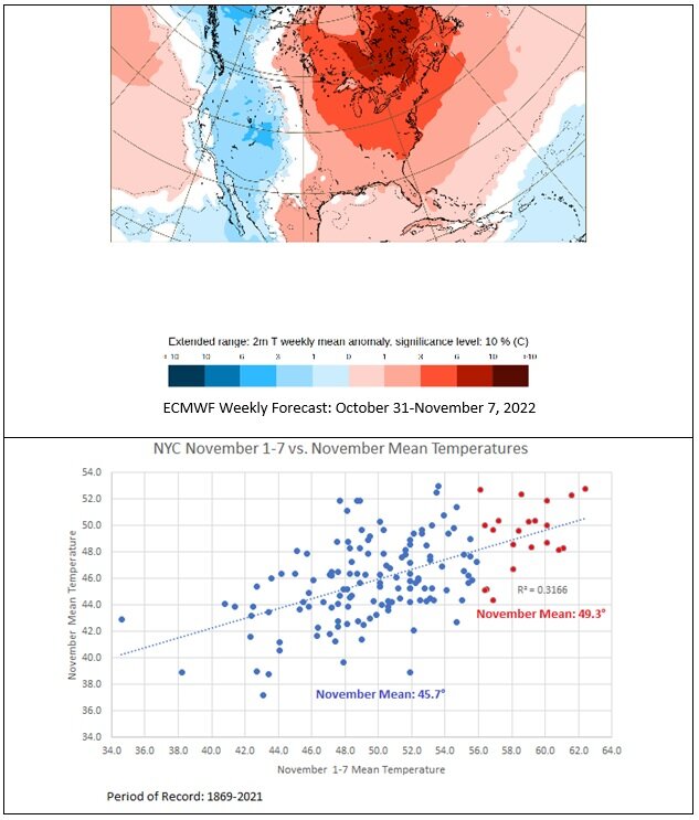
The first week of November continues to look exceptionally warm, especially in parts of Ontario, Quebec, and New England. The New York City area remains on track for a much warmer than normal November 1-7.
-
A cold front moved across the region earlier today. In its wake, slightly cooler air moved into the region. Overnight, it will turn much cooler. Tomorrow will be partly sunny and cool. Temperatures will stay in the 50s in most of the region. The weekend will also begin with cooler than normal readings but temperatures will be moderating by Sunday. Unseasonable warmth will return early next week. November could begin with warmer than normal temperatures. The ENSO Region 1+2 anomaly was -1.4°C and the Region 3.4 anomaly was -0.8°C for the week centered around October 19. For the past six weeks, the ENSO Region 1+2 anomaly has averaged -1.42°C and the ENSO Region 3.4 anomaly has averaged -0.83°C. La Niña conditions will likely persist through the fall. The SOI was +21.01 today. The preliminary Arctic Oscillation (AO) was +1.082 today. On October 25 the MJO was in Phase 7 at an amplitude of 1.839 (RMM). The October 24-adjusted amplitude was 1.887 (RMM). Based on sensitivity analysis applied to the latest guidance, there is an implied 92% probability that New York City will have a cooler than normal October (1991-2020 normal). October will likely finish with a mean temperature near 56.9° (1.0° below normal).
-
Morning thoughts… Today will be mostly sunny and a bit cooler. High temperatures will reach the lower and middle 60s in most of the region. Likely high temperatures around the region include: New York City (Central Park): 64° Newark: 65° Philadelphia: 66° Tomorrow will e noticeably cooler. Normals: New York City: 30-Year: 60.6°; 15-Year: 61.2° Newark: 30-Year: 61.9°; 15-Year: 62.6° Philadelphia: 30-Year: 63.1°; 15-Year: 63.2°
-
Tomorrow will be partly sunny and somewhat cooler. Readings will return to near normal or somewhat below noral levels to end the week. However, more warmth will likely return to start next week. With the MJO in Phase 6 at a high amplitude and the Arctic Oscillation forecast to be positive for the closing week of the month, the closing week of October could feature above to much above normal temperatures. November could begin with warmer than normal temperatures. The ENSO Region 1+2 anomaly was -1.4°C and the Region 3.4 anomaly was -0.8°C for the week centered around October 19. For the past six weeks, the ENSO Region 1+2 anomaly has averaged -1.42°C and the ENSO Region 3.4 anomaly has averaged -0.83°C. La Niña conditions will likely persist through the fall. The SOI was +0.71 today. The preliminary Arctic Oscillation (AO) was +1.558 today. On October 24 the MJO was in Phase 6 at an amplitude of 1.890 (RMM). The October 23-adjusted amplitude was 1.860 (RMM). Based on sensitivity analysis applied to the latest guidance, there is an implied 90% probability that New York City will have a cooler than normal October (1991-2020 normal). October will likely finish with a mean temperature near 56.9° (1.0° below normal).
-
It would be even warmer were there fewer clouds. Up in Quebec, record highs are widespread. Yesterday, Montreal hit 77°, its latest such temperature on record. Through 1 pm, it has a daily record 72° today.
-
JFK will probably come in close to normal perhaps a few tenths of a degree above. LGA, NYC, and EWR will be below normal, though LGA might wind up within 0.5° of normal.
-
I'm using the 1991-2020 normals, which are warmer than the prior 1981-2010 ones.
-
Yes. The prior record of 77° was set in 2001.
-
The afternoon will be similar to yesterday. There will be some breaks in the clouds in some areas.
-
Morning thoughts… Today will be mostly cloudy with some early fog and drizzle. High temperatures will reach the upper 60s and lower 70s in most of the region. Likely high temperatures around the region include: New York City (Central Park): 70° Newark: 71° Philadelphia: 71° Cooler air could return late in the week. Normals: New York City: 30-Year: 60.9°; 15-Year: 61.2° Newark: 30-Year: 62.3°; 15-Year: 63.0° Philadelphia: 30-Year: 63.4°; 15-Year: 63.6°
-
78 degrees.
-
There was an extended period of below normal readings.
-
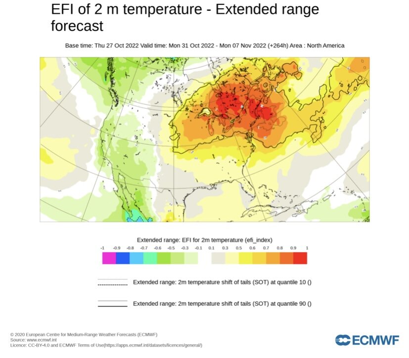
The latest ECMWF weekly forecast suggests that the New York City area will see temperatures run 3°C-6°C (5.4°F-10.8°F) above normal during the first week of November. Such warmth has typically indicated a warmer than normal November.Parts of E. Canada will be even warmer.
-
Morning fog lifted and the clouds broke for a time. As a result, the mercury rose into the 70s in many parts of the region this afternoon. Highs included: Islip: 75° New York City-Central Park: 70° New York City-JFK: 73° Newark: 73° Philadelphia: 70° Tomorrow will be another variably cloudy and warm day following some fog and drizzle. With the MJO in Phase 6 at a high amplitude and the Arctic Oscillation forecast to be positive for the closing week of the month, the closing week of October could feature above to much above normal temperatures. November could begin with warmer than normal temperatures. The ENSO Region 1+2 anomaly was -1.4°C and the Region 3.4 anomaly was -0.8°C for the week centered around October 19. For the past six weeks, the ENSO Region 1+2 anomaly has averaged -1.42°C and the ENSO Region 3.4 anomaly has averaged -0.83°C. La Niña conditions will likely persist through the fall. The SOI was +12.44 today. The preliminary Arctic Oscillation (AO) was +1.558 today. On October 23 the MJO was in Phase 6 at an amplitude of 1.860 (RMM). The October 22-adjusted amplitude was 1.536 (RMM). Based on sensitivity analysis applied to the latest guidance, there is an implied 83% probability that New York City will have a cooler than normal October (1991-2020 normal). October will likely finish with a mean temperature near 57.1° (0.8° below normal).
-
It could. Merbok likely altered the pattern leading to 3-4 weeks of generally below normal temperatures.
-
October will be 0.5-1.5 degrees below normal across the area. There’s a stronger correlation between December and seasonal snowfall than temperatures.
-
Morning thoughts… Today will be mostly cloudy with some showers and drizzle. High temperatures will reach the upper 60s in most of the region. Likely high temperatures around the region include: New York City (Central Park): 68° Newark: 69° Philadelphia: 71° Cooler air could return late in the week. Normals: New York City: 30-Year: 61.2°; 15-Year: 61.6° Newark: 30-Year: 62.7°; 15-Year: 63.4° Philadelphia: 30-Year: 63.8°; 15-Year: 64.0°
-
That’s the way it currently looks. Whether it turns colder late in the month remains to be seen.
-
Although the ongoing system has generally produced less rainfall than modeled, a few locations saw more than 0.50" of rain. Through 5 pm, Philadelphia had picked up 0.72" today. Islip had received 1.16". Tomorrow will be variably cloudy and warmer. Additional showers are possible. Wednesday will be another warm day. With the MJO having come out of Phase 6 at a high amplitude and the Arctic Oscillation forecast to be positive for the closing week of the month, the closing week of October could feature above to much above normal temperatures. November could begin with warmer than normal temperatures. The ENSO Region 1+2 anomaly was -2.0°C and the Region 3.4 anomaly was -0.8°C for the week centered around October 12. For the past six weeks, the ENSO Region 1+2 anomaly has averaged -1.33°C and the ENSO Region 3.4 anomaly has averaged -0.87°C. La Niña conditions will likely persist through the fall. The SOI was +22.75 today. The preliminary Arctic Oscillation (AO) was +1.664 today. On October 22 the MJO was in Phase 7 at an amplitude of 1.535 (RMM). The October 21-adjusted amplitude was 1.386 (RMM). Based on sensitivity analysis applied to the latest guidance, there is an implied 75% probability that New York City will have a cooler than normal October (1991-2020 normal). October will likely finish with a mean temperature near 57.2° (0.7° below normal).
-
Morning thoughts… Today will be mostly cloudy with some showers and periods of rain. High temperatures will reach the lower and middle 60s in most of the region. Likely high temperatures around the region include: New York City (Central Park): 63° Newark: 64° Philadelphia: 65° It will become noticeably warmer tomorrow. Normals: New York City: 30-Year: 61.6°; 15-Year: 62.0° Newark: 30-Year: 63.0°; 15-Year: 63.8° Philadelphia: 30-Year: 64.2°; 15-Year: 64.5°
-
Parts of the region experienced occasional showers and light rain during the afternoon into the evening. Periods of rain will continue into tomorrow. Philadelphia, Newark, and New York City will likely see 0.25"-0.75" of rain. There will likely be a general 0.50"-1.50" of rain east of New York City into southern New England, including Bridgeport, Islip, and Boston. Additional showers are possible on Tuesday. With the MJO having come out of Phase 6 at a high amplitude and the Arctic Oscillation forecast to be positive for the closing week of the month, the closing week of October could feature above to much above normal temperatures. November could begin with warmer than normal temperatures. The ENSO Region 1+2 anomaly was -2.0°C and the Region 3.4 anomaly was -0.8°C for the week centered around October 12. For the past six weeks, the ENSO Region 1+2 anomaly has averaged -1.33°C and the ENSO Region 3.4 anomaly has averaged -0.87°C. La Niña conditions will likely persist through the fall. The SOI was +23.59 today. The preliminary Arctic Oscillation (AO) was +1.404 today. On October 21 the MJO was in Phase 7 at an amplitude of 1.380 (RMM). The October 20-adjusted amplitude was 1.222 (RMM). Based on sensitivity analysis applied to the latest guidance, there is an implied 66% probability that New York City will have a cooler than normal October (1991-2020 normal). October will likely finish with a mean temperature near 57.3° (0.6° below normal).
-
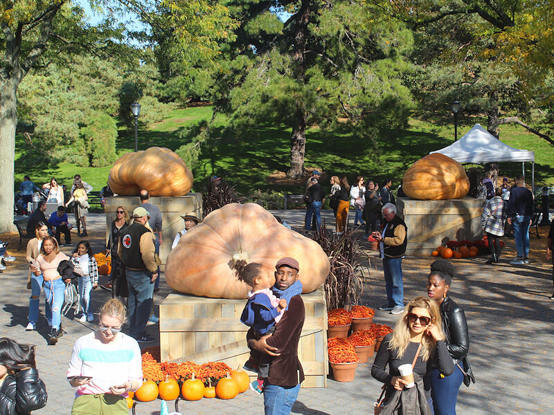
I expect the 3,000 pound threshold to be surpassed within the next few years.
-
Under bright sunshine, the temperature rose into the middle and upper 60s across the region. Philadelphia saw the temperature peak at 70°. Out West, Lincoln, NE hit 82°. Three days earlier, Lincoln registered at low temperature of 16°. The 82° high is the highest October temperature 3 or fewer days after a 16° or colder low temperature. The prior mark was 67°, which occurred on October 28, 1887 following a 15° low temperature three days earlier. Tomorrow, the mercury could rise into the upper 80s and perhaps make a run at 90°. In the northern Mid-Atlantic and southern New England areas, tomorrow will become mostly cloudy. Rain will arrive and continue into Monday. Philadelphia, Newark, and New York City will likely see 0.25"-0.75" of rain. There will likely be a general 0.50"-1.50" of rain east of New York City into southern New England, including Bridgeport, Islip, and Boston. Afterward, with the MJO currently in Phase 6 at a high amplitude and the Arctic Oscillation forecast to be positive for the closing week of the month, the closing week of October could feature above to much above normal temperatures. The ENSO Region 1+2 anomaly was -2.0°C and the Region 3.4 anomaly was -0.8°C for the week centered around October 12. For the past six weeks, the ENSO Region 1+2 anomaly has averaged -1.33°C and the ENSO Region 3.4 anomaly has averaged -0.87°C. La Niña conditions will likely persist through the fall. The SOI was +17.34 today. The preliminary Arctic Oscillation (AO) was +0.746 today. On October 20 the MJO was in Phase 6 at an amplitude of 1.220 (RMM). The October 19-adjusted amplitude was 1.132 (RMM). Based on sensitivity analysis applied to the latest guidance, there is an implied 63% probability that New York City will have a cooler than normal October (1991-2020 normal). October will likely finish with a mean temperature near 57.3° (0.6° below normal).
-
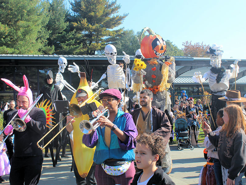
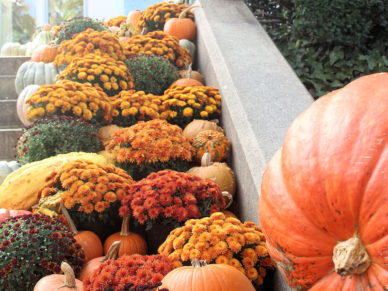
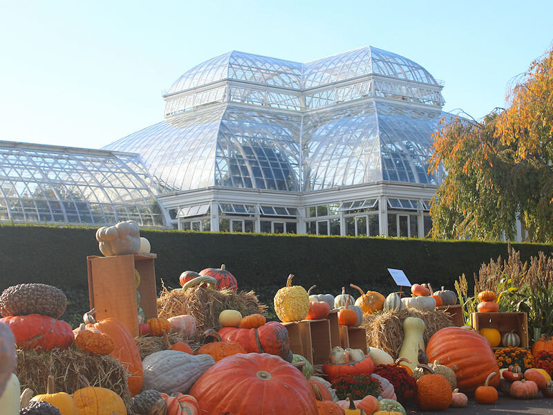
Under mostly sunny skies, the temperature soared into the middle 60s in New York City. The giant pumpkins, one of which weighed in at 2,554 pounds, had arrived to the New York Botanical Garden. Overall, it was a festive mid-autumn day.
-
IMO, the month will be 0.5 degrees to 1.0 degrees below normal in most of the region. Yesterday’s guidance may have been a bit aggressive on the closing week’s warmth.


