donsutherland1
-
Posts
23,768 -
Joined
Content Type
Profiles
Blogs
Forums
American Weather
Media Demo
Store
Gallery
Everything posted by donsutherland1
-
Morning thoughts… Today will be partly to mostly cloudy and very mild. High temperatures will reach the upper 40s and lower 50s in most areas. Likely high temperatures around the region include: New York City (Central Park): 51° Newark: 53° Philadelphia: 55° Cooler air will return tomorrow. A short Arctic blast is likely toward the end of the week. Normals: New York City: 30-Year: 39.7°; 15-Year: 39.9° Newark: 30-Year: 40.2°; 15-Year: 40.6° Philadelphia: 30-Year: 41.5°; 15-Year: 41.7°
-
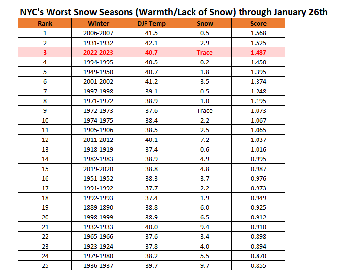
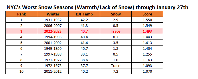
New York City's snow season futility rankings through January 29th:
-
JFK and Central Park share the 332-day record.
-
The list was latest first measurable snowfall. You’re thinking of the longest stretch without measurable snow.
-
Today’s split was 53-42.
-
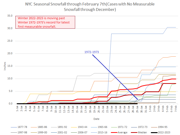
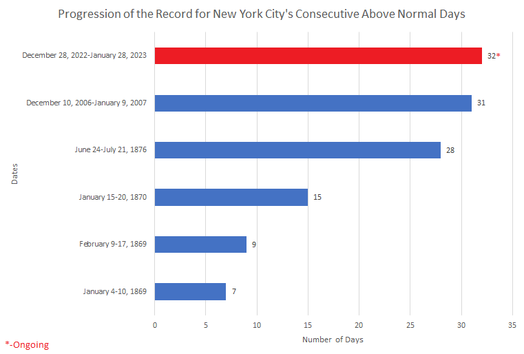
Today was New York City's 33rd consecutive warmer than normal day. That extended the ongoing record. The prior record of 31 days was set during December 10, 2006 through January 9, 2007. Today will also be New York City's 10th day this month with a low temperature of 40° or above. That would tied the January record set in 1932. Tomorrow will be another mild day. However, colder air will begin to return to the region late tomorrow. Winter 2022-2023 has now surpassed the record for latest first measurable snowfall in New York City. The old record of January 29th was set in 1973. It is likely that New York City will get through all of January without a measurable snowfall. A cooler pattern will move in during the first week of February and last through the week. That pattern will be highlighted by a brief Arctic blast. Saturday could be the coldest day with the temperature rising only into the upper teens and lower 20s during the daytime after a morning low in the single digits to perhaps lower teens in New York City and possibly near zero outside the City. The onset of this cooler period might afford some opportunities for snowfall, but a snowy outcome remains far from certain. Afterward, moderation will likely commence during the second week of the month. The ENSO Region 1+2 anomaly was -0.3°C and the Region 3.4 anomaly was -0.6°C for the week centered around January 11. For the past six weeks, the ENSO Region 1+2 anomaly has averaged -0.30°C and the ENSO Region 3.4 anomaly has averaged -0.75°C. La Niña conditions are beginning to fade and they should evolve to neutral conditions during late winter or early spring. The SOI was +16.26 today. The preliminary Arctic Oscillation (AO) was +1.729 today. On January 27 the MJO was in Phase 3 at an amplitude of 2.066 (RMM). The January 26-adjusted amplitude was 1.937 (RMM). Based on sensitivity analysis applied to the latest guidance, there is an implied near 100% probability that New York City will have a warmer than normal January (1991-2020 normal). January will likely finish with a mean temperature near 43.0° (9.3° above normal). That will rank January 2023 as the second warmest January on record.
-
As does Central Park.
-
I recall the big sleet storms in 2007.
-
Morning thoughts… Today will be partly cloudy and very mild. High temperatures will reach the lower 50s in most areas. Likely high temperatures around the region include: New York City (Central Park): 52° Newark: 54° Philadelphia: 53° The mild weather will continue through tomorrow before it turns colder. Normals: New York City: 30-Year: 39.6°; 15-Year: 39.9° Newark: 30-Year: 40.1°; 15-Year: 40.6° Philadelphia: 30-Year: 41.4°; 15-Year: 41.6°
-
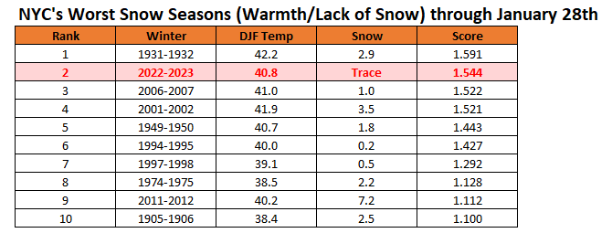
New York City's snow season futility rankings through January 28th:
-
No. January 4, 1932 was slightly below normal.
-
Yes. The high was 60 and the low was 33.
-
The January 1-30, 1932 mean temperature was 43.7.
-
The split was 33-24.
-
I believe the 31st will deny us the record.
-
Today was New York City's 32nd consecutive warmer than normal day. That broke the all-time record of 31 days, which was set during December 10, 2006 through January 9, 2007. All two cases with 30 consecutive such days have occurred since 2000. One-third of streaks of 20 or more such days have occurred since 2000. Tomorrow and Monday will be mild days. However, colder air will begin to return to the region late Monday. New York City will see its latest ever first measurable snowfall of the season. The existing record of January 29th was set in 1973. It is likely that New York City will get through all of January without a measurable snowfall. A cooler pattern will move in during the first week of February and last through the week. Saturday could be the coldest day with the temperature rising only into the lower or middle 20s with a low temperature in the low teens in New York City and single digits outside the City. The onset of this cooler period might afford some opportunities for snowfall, but a snowy outcome remains far from certain. Afterward, moderation could begin to occur during the second week of the month. The ENSO Region 1+2 anomaly was -0.3°C and the Region 3.4 anomaly was -0.6°C for the week centered around January 11. For the past six weeks, the ENSO Region 1+2 anomaly has averaged -0.30°C and the ENSO Region 3.4 anomaly has averaged -0.75°C. La Niña conditions are beginning to fade and they should evolve to neutral conditions during late winter or early spring. The SOI was +8.63 today. The preliminary Arctic Oscillation (AO) was +0.991 today. On January 26 the MJO was in Phase 3 at an amplitude of 1.937 (RMM). The January 25-adjusted amplitude was 1.958 (RMM). Based on sensitivity analysis applied to the latest guidance, there is an implied near 100% probability that New York City will have a warmer than normal January (1991-2020 normal). January will likely finish with a mean temperature near 42.7° (9.0° above normal). That will rank January 2023 as the second warmest January on record.
-
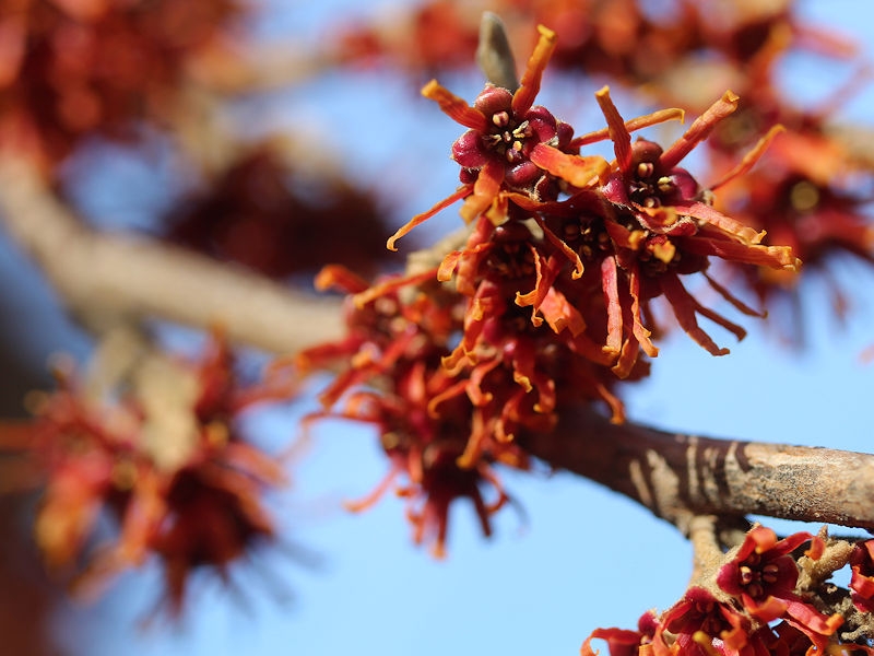
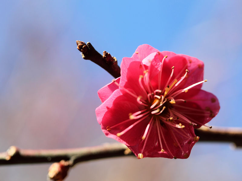
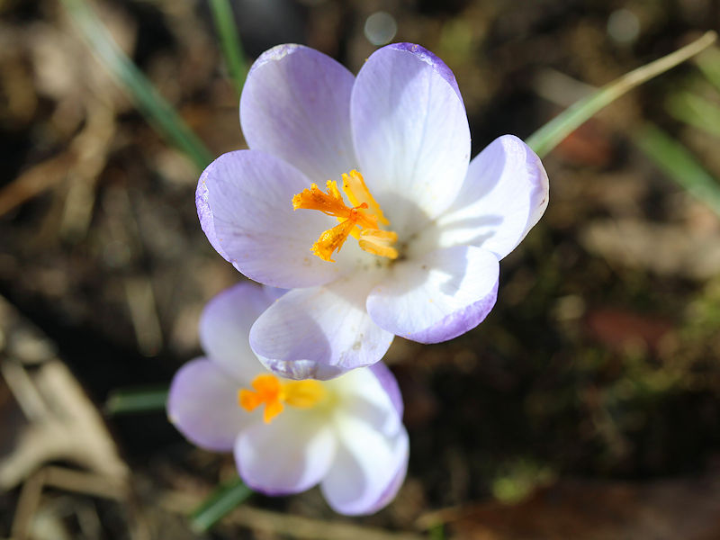
January 28, 2023 at the New York Botanical Garden (Bronx, New York). 1. Ozark witch-hazel 2. Amur adonis 3. Japanese apricot 4. Crocuses 5. Hoop petticoat daffodil 6. Japanese mahonia


-
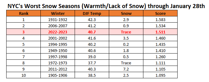
Snow season futility rankings through January 27th:
-
Morning thoughts… Clouds will increase today. It will be unseasonably mild. High temperatures will reach the upper 40s and lower 50s in most areas. Likely high temperatures around the region include: New York City (Central Park): 49° Newark: 51° Philadelphia: 52° The mild weather will continue through Monday before it turns colder. Normals: New York City: 30-Year: 39.5°; 15-Year: 39.8° Newark: 30-Year: 40.0°; 15-Year: 40.5° Philadelphia: 30-Year: 41.3°; 15-Year: 41.6°
-
With a low temperature of 36°, New York City's Central Park will record its 32nd consecutive above normal mean temperature. That sets a new record.
-
That’s true. Good point.
-
Tomorrow will be partly sunny and mild. The mercury approach or reach 50° in New York City. New York City is now on track to see its latest ever first measurable snowfall of the season. The existing record of January 29th was set in 1973. There is a distinct possibility that New York City could get through all of January without a measurable snowfall. A cooler pattern will move in during the first week of February and last through the week. The onset of this cooler period might afford some opportunities for snowfall, but a snowy outcome remains far from certain. Afterward, moderation could begin to occur during the second week of the month. The ENSO Region 1+2 anomaly was -0.3°C and the Region 3.4 anomaly was -0.6°C for the week centered around January 11. For the past six weeks, the ENSO Region 1+2 anomaly has averaged -0.30°C and the ENSO Region 3.4 anomaly has averaged -0.75°C. La Niña conditions are beginning to fade and they should evolve to neutral conditions during late winter or early spring. The SOI was -3.48 today. The preliminary Arctic Oscillation (AO) was +0.826 today. On January 25 the MJO was in Phase 3 at an amplitude of 1.959 (RMM). The January 24-adjusted amplitude was 1.589 (RMM). Based on sensitivity analysis applied to the latest guidance, there is an implied near 100% probability that New York City will have a warmer than normal January (1991-2020 normal). January will likely finish with a mean temperature near 42.5° (8.8° above normal). That will rank January 2023 as the second warmest January on record.
-
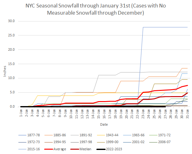
Winter 2022-2023 seems to have "flat-lined." Is there an Automated External Defibrillator to shock some life into Winter 2022-2023? Snowfall outcomes for all cases where NYC saw no measurable snow through December 31st.
-
I agree.
-
Here's the top 25: