donsutherland1
-
Posts
23,768 -
Joined
Content Type
Profiles
Blogs
Forums
American Weather
Media Demo
Store
Gallery
Everything posted by donsutherland1
-
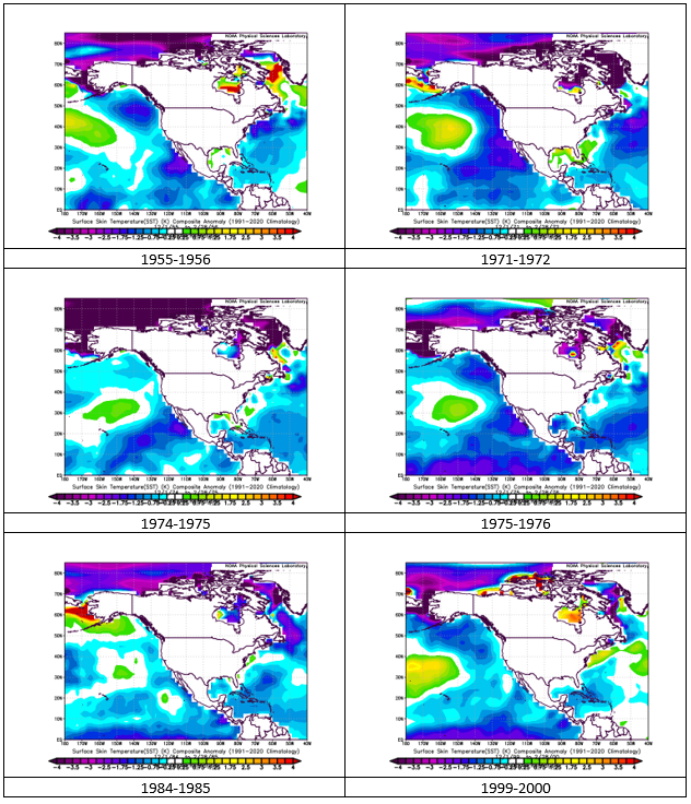
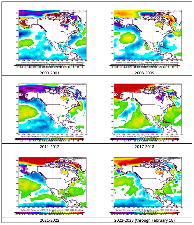
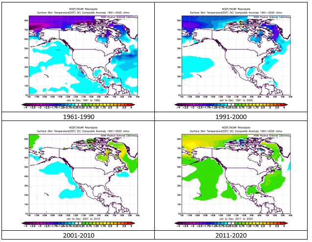
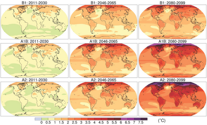
I believe that there is a lot more to the story. ENSO can have some impact via the upper air patterns, but there's more to the story. If one looks at all second and third year La Niña events, the Atlantic SSTA picture is mixed. The Atlantic anomalies are warmer in recent years and generally colder in earlier ones. That seems to reflect a longer-term evolution of SSTAs that is underway. Second and Third Year La Niña Events: Longer-Term Evolution of Atlantic SSTAs: Indeed, the longer-term evolution appears to be consistent with the expectations from the climate models for a range of scenarios. From the IPCC:
-
Morning thoughts… Today will be mostly cloudy. Additional showers are likely during the afternoon. High temperatures will reach the upper 40s and lower 50s in most areas. Likely high temperatures around the region include: New York City (Central Park): 49° Newark: 52° Philadelphia: 57° Tomorrow will be somewhat cooler. Normals: New York City: 30-Year: 43.4°; 15-Year: 43.5° Newark: 30-Year: 44.3°; 15-Year: 44.5° Philadelphia: 30-Year: 45.7°; 15-Year: 45.5°
-
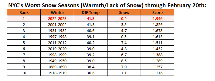
New York City's snow season futility rankings through February 20th:
-
During a sun-filled afternoon, temperatures reached the lower 60s in much of the region. Tomorrow will be mainly cloudy and cooler. Some showers are possible. Temperatures will run generally above to much above normal through the much of the remainder of February. Nevertheless, a brief cool shot could afford an opportunity for a snowfall in the Mid-Atlantic region during the February 23-25 timeframe. More than likely, any snowfall would be modest. A snowfall is not a guaranteed outcome. No severe shots of cold appear likely through February. Among the extended range scenarios on the table is a late February-early March 2002-type outcome. Under such a scenario, cold air would flood into the Plains States, but persistent southeast ridging would keep most of the cold away from the northeastern and Mid-Atlantic United States. During February 28-March 5, 2002 high temperatures in the New York City area generally reached the lower to middle 40s with low temperatures in the 20s at night. At the height of the cold, one night saw the temperature fall into the upper teens. By March 7, the cold was gone and readings returned to much above normal levels. The latest ECMWF weekly forecast suggests that the second week of March could see near normal readings. Uncertainty remains high. The ENSO Region 1+2 anomaly was +0.8°C and the Region 3.4 anomaly was -0.5°C for the week centered around February 15. For the past six weeks, the ENSO Region 1+2 anomaly has averaged +0.15°C and the ENSO Region 3.4 anomaly has averaged -0.56°C. La Niña conditions fading and they should evolve to neutral conditions during late winter or early spring. The SOI was +10.90 today. The preliminary Arctic Oscillation (AO) was +2.886 today. On February 18 the MJO was in Phase 7 at an amplitude of 1.998 (RMM). The February 17-adjusted amplitude was 2.123 (RMM). Based on sensitivity analysis applied to the latest guidance, there is an implied near 100% probability that New York City will have a warmer than normal February (1991-2020 normal). February will likely finish with a mean temperature near 41.2° (5.3° above normal).
-
Maybe a little hope on the ECMWF weeklies? The following week is coldest with anomalies between 0°C and 1.0°C below normal. Of course, by then normal highs are around 49° with normal lows around 35°.
-
Yes, that’s correct about phase 8.
-
In general, as noted on a number of occasions in the past, one should make or accept extreme forecasts without sufficient evidence for such an outcome. Without sufficient evidence, contextual understanding, and respect for uncertainty in the extended range, such forecasts are almost always doomed to fail. The March 1-April 15 forecast anomaly of 5° below normal for New York City provides the latest example. March has yet to begin, but some of the ensembles now extend into the opening days of March. For an illustration of where things stand, the EPS forecasts a March 1-6 anomaly of 0.7° below normal. That the EPS is also potentially evolving toward a warmer pattern is set aside. In fact, by 360 hours, the 2/20 0z run shows a 500 mb pattern similar to that of March 9, 2006 that preceded a period of above normal temperatures. At that range, a lot can still change. But going back to the forecast -0.7° anomaly, if that anomaly verifies, then the remainder of the period March 7-April 15 would need to average 5.6° below normal to achieve a 5° below normal average for March 1-April 15. Put simply, as March approaches, extent of cold needed to achieve the extreme forecast will need to become even more extreme. In sum, unless overwhelming and credible evidence is presented, extreme forecasts over long timeframes are little more than speculation. There is no skill involved. There is no insight that informs them. The probability of their verifying is very low. If anything, they are noise seeking to grab the attention of social media, not legitimate attempts to inform the public. The forecast in question will be verified at the end of the timeframe with periodic updates for purposes of illustrating the important points concerning extreme forecasts made in the absence of sufficient and credible evidence.
-
UncleW might know more. However, at that time only a limited number of observations were made. Thus, a late night or predawn low temperature might not have been observed.
-
That minimum temperature is an error. It seems that some of the data in Xmacis was messed up following an outage. The record high minimum temperature for July 2 is 82 in 1901.
-
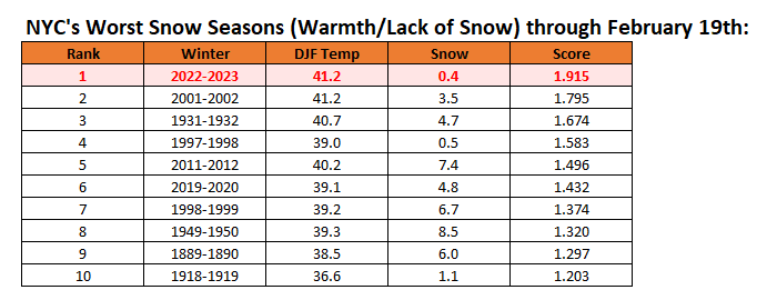
New York City's snow season futility rankings through February 19th:
-
Despite considerable mid- and high-level clouds, the mercury rose into the lower 50s across the region today. Tomorrow will be even milder. Temperatures will run generally above to much above normal through the much of the remainder of February. Nevertheless, a brief cool shot could afford an opportunity for a snowfall in the Mid-Atlantic region during the February 23-25 timeframe. More than likely, any snowfall would be modest. A snowfall is not a guaranteed outcome. No severe shots of cold appear likely through February. Among the extended range scenarios on the table is a late February-early March 2002-type outcome. Under such a scenario, cold air would flood into the Plains States, but persistent southeast ridging would keep most of the cold away from the northeastern and Mid-Atlantic United States. During February 28-March 5, 2002 high temperatures in the New York City area generally reached the lower to middle 40s with low temperatures in the 20s at night. At the height of the cold, one night saw the temperature fall into the upper teens. By March 7, the cold was gone and readings returned to much above normal levels. The ENSO Region 1+2 anomaly was +0.7°C and the Region 3.4 anomaly was -0.5°C for the week centered around February 8. For the past six weeks, the ENSO Region 1+2 anomaly has averaged -0.12°C and the ENSO Region 3.4 anomaly has averaged -0.62°C. La Niña conditions fading and they should evolve to neutral conditions during late winter or early spring. The SOI was +4.18 today. The preliminary Arctic Oscillation (AO) was +2.515 today. On February 17 the MJO was in Phase 7 at an amplitude of 2.147 (RMM). The February 16-adjusted amplitude was 2.003 (RMM). Based on sensitivity analysis applied to the latest guidance, there is an implied near 100% probability that New York City will have a warmer than normal February (1991-2020 normal). February will likely finish with a mean temperature near 41.3° (5.4° above normal).
-
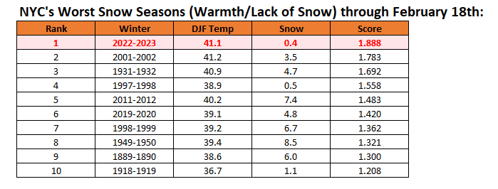
Yes, it was a bad night on the models, but not that surprising. 9 of the 10 most “futile” winters through February 18th (excluding the current one) had less than 15” snowfall when the season ended. The top 5 had less than 10”. Only 1889-90, from a much colder climate era, reached 20” (24.4”).
-
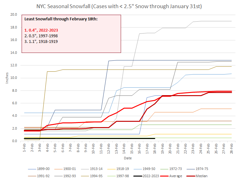
In the world we inhabit, some things are eminently predictable. The sun rises and sets. Dropped objects fall to the ground. The tide rises and falls. And, as @snowman19 reminded readers just this morning--at least those willing to listen--modeled snowstorms disappear into the abyss of winter 2022-2023. It has long been said that there is always change. But not for the finite time that marks the saddest winters ever known to those who suffer through them. There is something special and sinister about winters such as 1918-1919, 1972-1973, 2001-2002, 2019-2020, and perhaps 2022-2023. During those "ratter" winters, opportunities for snowstorms are missed. The snow does not fall. Nevertheless, some refuse to accept the reality of the circumstances in which they find themselves. They cling fast to hollow aphorisms about the snow being "delayed but not denied." They are seduced by the siren call of MJO charts with low long-range verification scores and often low correlation outcomes. They are smitten by dusty analogs of a colder, snowier world that once was. The snow drought persists day after day. Sleighs go unused. There is no romance to be found in such winters. The hourglass empties. The sun's warmth grows. Spring blossoms begin to unfurl their colors to herald the coming change in seasons. The ship of "Winter 2022-2023" has now crossed mid-February. Central Park's barren ground has seen just 0.4" of snow. Even as the forsaken ship flounders on the stormy seas of warmth, a voice cries out from its Twitter watchtower: "Big snow, severe cold on the horizon!" Its confidence is unmistakable. It seems possessed of the certainty that only exists in such matters as the rising and setting of the sun. It appears that this voice has never felt the sting of its own countless busted forecasts for cold and snow that lie in the ship's wake as far back as the eye can see. It is undeterred that the analogs on which its forecasts are based have long ago melted in the rising warmth of climate change rendering them useless. It proclaims for New York City, "5° below normal, 20" of snow, from March 1 to April 15!" That the horizon is perpetually shrouded by the mist of uncertainty is irrelevant. Its confidence is complete. Instead, what seems increasingly likely is that this stricken ship will sink beneath the battering waves of winter futility long before it ever reaches a cold and snowy destination. There are rare miracles. The 5" snowstorm on March 22, 1998 after 0.5" had fallen all winter until then offers one example. Hope has not yet succumbed to hopelessness. The story of Winter 2022-2023 is nearly finished. Its last pages will be written over the next two months. What will those pages say? How will the story end? Will the ship of winter be lost?

-
Morning thoughts… Today will be variably cloudy and much milder. High temperatures will reach the lower and middle 50s in most areas. Likely high temperatures around the region include: New York City (Central Park): 51° Newark: 54° Philadelphia: 55° With the exception of Wednesday, readings will be generally above normal through Friday. Normals: New York City: 30-Year: 43.0°; 15-Year: 43.0° Newark: 30-Year: 43.9°; 15-Year: 44.0° Philadelphia: 30-Year: 45.2°; 15-Year: 45.0°
-
New York City's snow season futility rankings through February 18th:
-
It can happen, but it’s not common.
-
It’s encouraging that model support exists. Hopefully, this potential opportunity will be realized.
-
More and more blossoms are coming into bloom at the New York Botanical Garden. Inside the annual Orchid show is underway.


-
After a brisk sun-filled day, readings will rebound tomorrow. Temperatures will run generally above to much above normal through the much of the remainder of February. Nevertheless, a brief cool shot could afford an opportunity for a snowfall in the Mid-Atlantic region during the February 23-25 timeframe. More than likely, any snowfall would be modest. At this timeframe, a snowfall is not a guaranteed outcome. No severe shots of cold appear likely through February. Among the extended range scenarios on the table is a late February-early March 2002-type outcome. Under such a scenario, cold air would flood into the Plains States, but persistent southeast ridging would keep most of the cold away from the northeastern and Mid-Atlantic United States. During February 28-March 5, 2002 high temperatures in the New York City area generally reached the lower to middle 40s with low temperatures in the 20s at night. At the height of the cold, one night saw the temperature fall into the upper teens. By March 7, the cold was gone and readings returned to much above normal levels. The ENSO Region 1+2 anomaly was +0.7°C and the Region 3.4 anomaly was -0.5°C for the week centered around February 8. For the past six weeks, the ENSO Region 1+2 anomaly has averaged -0.12°C and the ENSO Region 3.4 anomaly has averaged -0.62°C. La Niña conditions fading and they should evolve to neutral conditions during late winter or early spring. The SOI was +4.56 today. The preliminary Arctic Oscillation (AO) was +1.773 today. On February 16 the MJO was in Phase 6 at an amplitude of 2.001 (RMM). The February 15-adjusted amplitude was 1.930 (RMM). Based on sensitivity analysis applied to the latest guidance, there is an implied near 100% probability that New York City will have a warmer than normal February (1991-2020 normal). February will likely finish with a mean temperature near 41.3° (5.4° above normal).
-
It’s much less of a factor, as long as it’s not strongly negative (-1 or below).
-
It likely is an important part of that story.
-
It may have something to do with the ongoing marine heatwave in the northwestern Atlantic Ocean.
-
How New York City's winters with the least snowfall through January 31st progressed through February:
-
No. It's only through February 17th. In the final rankings, excluding this winter, 2001-2002 ranked 1st and 1931-1932 ranked 2nd.
-
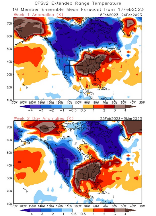
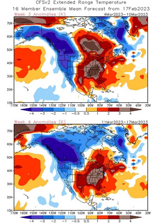
The CFSv2 is warm throughout 4 weeks. I am not sold on the CFSv2 idea, but could see a briefly cooler start to March (not severely cold) with a rebound in temperatures during the second week of the month. That's the scenario that is beginning to show up on the extended range of the EPS. It's also the scenario that played out in late February-early March 2002. Below are the CFSv2 maps: