donsutherland1
-
Posts
23,765 -
Joined
Content Type
Profiles
Blogs
Forums
American Weather
Media Demo
Store
Gallery
Everything posted by donsutherland1
-
Following the upcoming warmup after this weekend, we'll need to wait until after the first or second weeks of February for more opportunities for cold and snow. Following the jet extension, if the North Pacific Jet shifts Equatorward, that would favor a return to cold. If, however, the North Pacific Jet remains or shifts further Poleward, that would potentially delay the return of cold. Most of the guidance suggests that the first week of February will at least start mild. ENSO climatology associated with strong El Niño event favors cooler weather especially in the days leading up to and going beyond mid-month. Given ENSO climatology, I suspect that there will be some additional opportunities for snow in February, even if there is no extreme cold.
-
Through 1 pm, snowfall amounts included: Atlantic City: 1.3" Baltimore: 4.1" New York City: 0.1" Newark: 0.6" Philadelphia: 2.9" Washington, DC: 3.3" There were some 6.0" amounts. Areas receiving 6.0" of snow included Clayton, Dover, and Middletown in Delaware. Following the storm, the temperature will fall into the teens in New York City tonight and again tomorrow night. Outlying areas could experience some single-digit cold. Tomorrow will be fair but very cold with the mercury struggling to reach the lower and middle 20s across the northern Mid-Atlantic region. Overall, this coming weekend will see this winter's coldest readings so far. Beyond that, the development of an EPO+/AO+ pattern will lead to a noticeable warming trend that could send temperatures well into the 40s across the region and even into the 50s in parts of the region. This warm period will very likely assure that January will wind up as a warmer than normal month and Winter 2023-24 will become yet another warmer than normal winter in the New York City and Philadelphia areas. The generally mild conditions could continue into the first week of February with only brief interruptions. The ENSO Region 1+2 anomaly was +0.9°C and the Region 3.4 anomaly was +1.9°C for the week centered around January 10. For the past six weeks, the ENSO Region 1+2 anomaly has averaged +1.18°C and the ENSO Region 3.4 anomaly has averaged +1.95°C. A basinwide El Niño event is ongoing. The ongoing El Niño event has recently peaked. The SOI was +20.45 today. The preliminary Arctic Oscillation (AO) was -0.535 today. Strong blocking in the final week of November, as occurred this year, has often been followed by frequent blocking in December and January. On January 17 the MJO was in Phase 4 at an amplitude of 2.729 (RMM). The January 16-adjusted amplitude was 2.667 (RMM). Based on sensitivity analysis applied to the latest guidance, there is an implied 87% probability that New York City will have a warmer than normal January (1991-2020 normal). January will likely finish with a mean temperature near 35.8° (2.1° above normal).
-
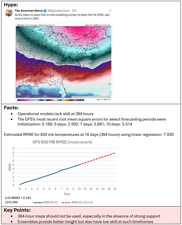
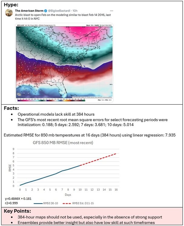
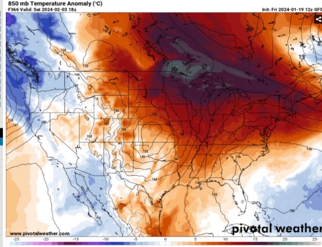
What happens when one posts maps for extreme cold from late November through December and the period winds up among the warmest on record? What happens when one posts maps of near historic cold in the Northeast to end December and start January but temperatures again average above normal? What happens when one posts a GGEM run showing 10”+ snow for NYC on January 19th with a PNA- pattern and it becomes clear that there will be no major snowstorm? Some punt ahead to hype another cold or snowy event. And how does the GFS look the following day for the same point in time? Although such maps remain well outside the skillful range, the dramatic change underscores the futility of latching onto unskillful guidance. Serious forecasters respect the limitations of models. They don’t exploit the models’ limitations to confirm biases and pursue clicks. Yet, that’s the kind of hype one finds on X/Twitter and other social media from several accounts on a frequent basis. Such hype damages the credibility of professional private and public sector meteorologists who consistently provide good forecasts, but who often are drowned out by the hype of those who seek clicks/views but then tarnished by the fallout resulting from the failed extreme forecasts made by those who hype extreme events. And even as some of the accounts frequently punt ahead with repeated calls for cold/snow, it’s important to remember that in the larger context, the periodic convergence of cold/snow with such calls is far more a matter of coincidence than skill.
-
That’s the way it seems right now. It could still be close.
-
2009-10 was the last such winter where Washington, DC received more snowfall than Boston. The longest stretch was 3 consecutive winters: 1934-35 through 1936-37.
-
Scattered flurries are now falling in Larchmont, NY.
-
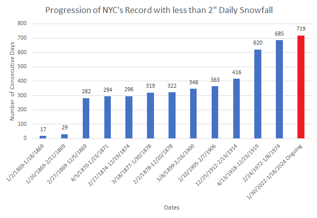
It's the 2" streak (today would be day 720).
-
Yes. My thinking is that Central Park will see a coating to 2" (1" being most likely but downside risk). The 12z national blend of model forecast is down to 1.2".
-
I doubt it. NYC is at 1.9". I think Central Park will see at least 0.5". Winter 2022-2023 had season-total snowfall of 2.3".
-
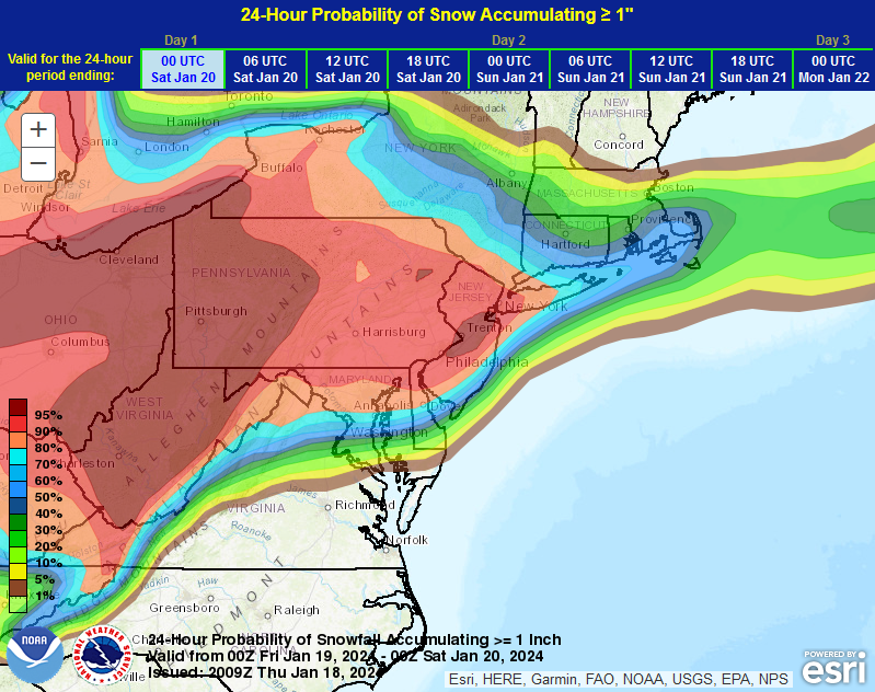
Based on overnight developments, it now appears likely that New York City's streak without reaching 2" or more daily snowfall will reach 720 days today and then continue to increase in coming days as Arctic air retreats and a much milder period sets in. Parts of the Mid-Atlantic region, notably central New Jersey southward to Washington, DC will likely see 3"-5" of snow with locally higher amounts of 6" or perhaps a little more. Central Park is now in line for a coating to 2" (1" being the most likely amount). Brooklyn, Queens, and Staten Island should see 1"-2". There remains a chance that Staten Island could see a few 3" amounts. Long Island will likely see 1"-3" with the highest amounts on the South Shore. Things could be worse. For example, the last January storm that saw 4" or more snow in Washington, DC, but a trace or less in New York City occurred on January 3, 2022. Washington, DC picked up 6.9" of snow. No snow fell in New York City. This storm will have a better northern edge, but only to the extent that New York City and its nearby suburbs pick up a light snowfall.
-
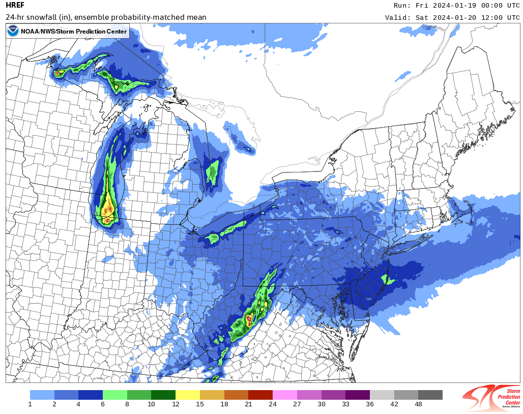
New York City, Newark, and nearby areas remain in line for 1"-3" of snow. Philadelphia and a swath of central New Jersey will likely see 3"-5" with some locally higher amounts of up to 6". The central and northern Hudson Valley will see a coating to an inch of snow. EPS and NBE Numbers: WPC Snowfall Probability Maps:
-
Was that for Central Park or another location?
-
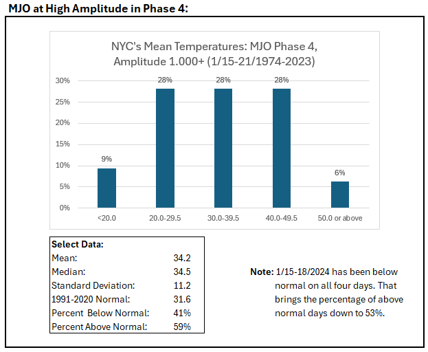
Phase 4 at high amplitude during January 18 +/- 3 days for NYC: In this case, it appears that a strong EPO-/AO- pattern has more than offset the impact of the MJO during January 15-18, 2024. With the AO forecast to rise rapidly to strongly positive values, the cold will quickly depart (as is currently modeled beyond the coming weekend).
-
A storm could impact the region Friday or Saturday. New York City, Newark, and nearby areas will pick up 1"-3" of snow. Philadelphia and a swath of central New Jersey will likely see 3"-5" with some locally higher amounts of up to 6". The central and northern Hudson Valley's will see a coating to an inch of snow. Following the storm, the temperature will likely fall into the teens in New York City during the weekend. This weekend will likely see this winter's coldest readings so far. Beyond that, a noticeable warming trend that could send temperatures well into the 40s across the region and even into the 50s in parts of the region will likely commence. This warm period will very likely assure that January will wind up as a warmer than normal month and Winter 2023-24 will become yet another warmer than normal winter in the New York City and Philadelphia areas. The ENSO Region 1+2 anomaly was +0.9°C and the Region 3.4 anomaly was +1.9°C for the week centered around January 10. For the past six weeks, the ENSO Region 1+2 anomaly has averaged +1.18°C and the ENSO Region 3.4 anomaly has averaged +1.95°C. A basinwide El Niño event is ongoing. The ongoing El Niño event has recently peaked. The SOI was +19.70 today. The preliminary Arctic Oscillation (AO) was -2.226 today. Strong blocking in the final week of November, as occurred this year, has often been followed by frequent blocking in December and January. On January 16 the MJO was in Phase 4 at an amplitude of 2.667 (RMM). The January 15-adjusted amplitude was 2.277 (RMM). Based on sensitivity analysis applied to the latest guidance, there is an implied 82% probability that New York City will have a warmer than normal January (1991-2020 normal). January will likely finish with a mean temperature near 35.7° (2.0° above normal).
-
Here's the 2" record (through today):
-
I agree with you, Walt. One of the underlying models must be skewing things. Let's see what the 0z HREF shows.
-
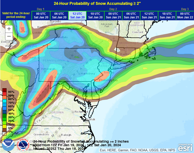
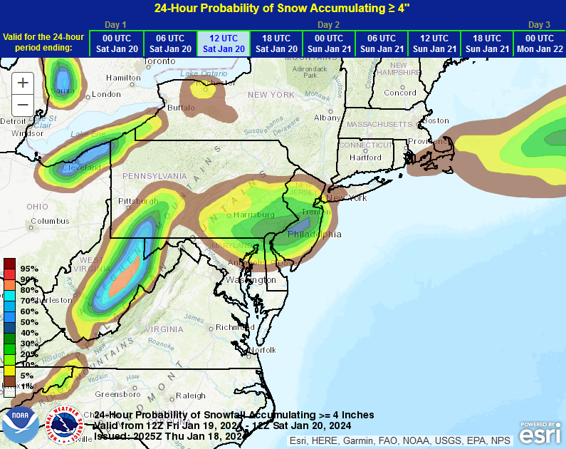
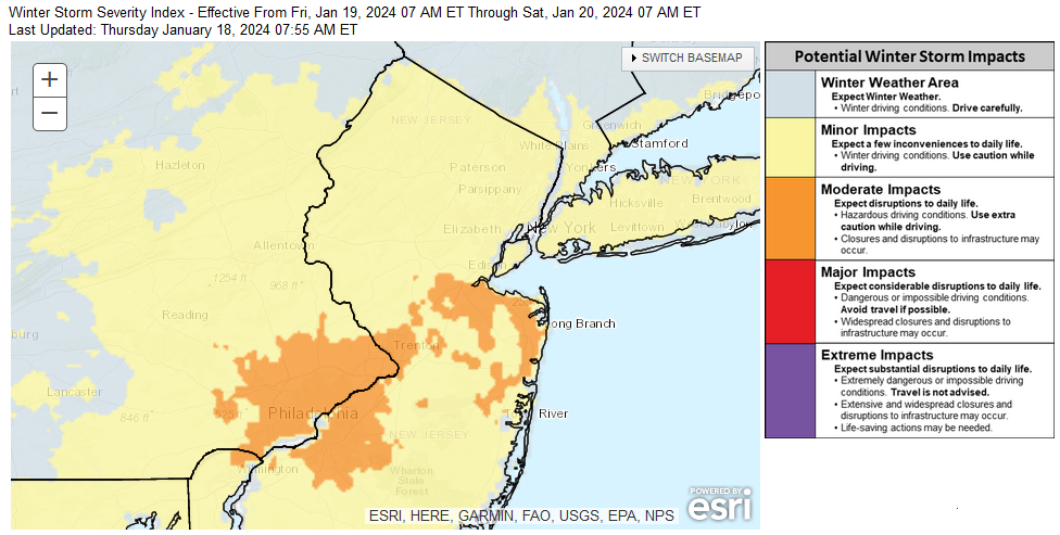
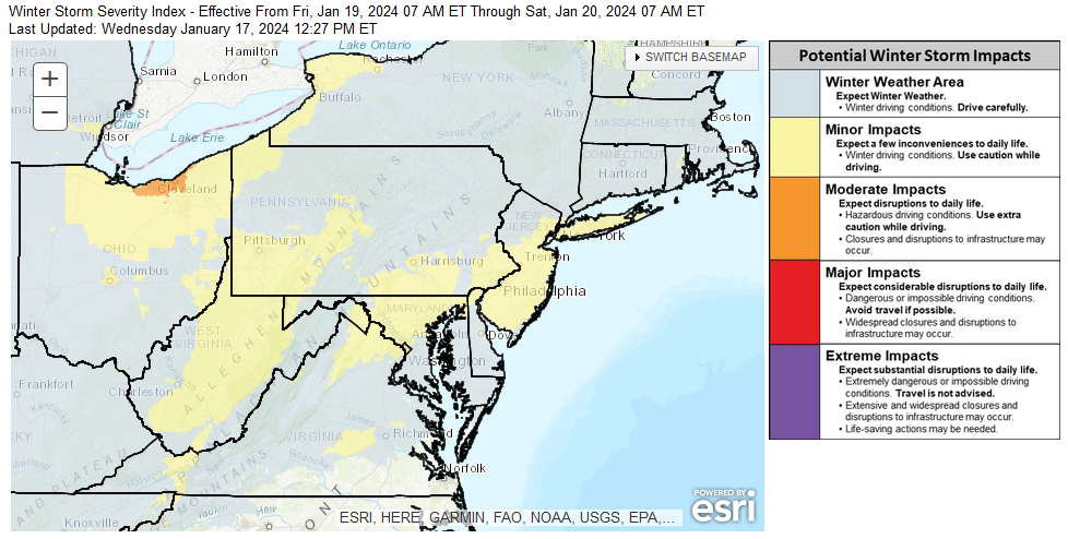
Things remain on track for a general 1"-3" snowfall in the New York City area tomorrow. Philadelphia, Trenton, and Belmar will likely see 2"-4" with that area possibly seeing some locally higher amounts of 6" as it is favored for the development of an inverted trough. There remains some uncertainty concerning the exact placement of the inverted trough. Once one gets north and west of White Plains, snowfall amounts will fall off. The northern Hudson Valley could see a coating to 1" of snow (with more downside risk than upside risk). Following this storm, New York City will have more snowfall this winter than it had for all of last winter. WPC's Winter Storm Severity Index: EPS and NBE Numbers: Historic Data: With the PNA's being negative, the probability of this week's storms being moderate or significant in New York City was low. During January, a PNA+ is associated with moderate or large snowstorms. The percentage of storms by snowfall amount with a PNA+ (January 1-31, 1950-2023): 4" or more: 66% 6" or more: 77% 10" or more: 89%
-
Right now, it doesn’t look like the area would be pounded by a series of big rainstorms.
-
Latest EPS and NBE data. The NBE seems to be focusing the highest snowfall in an area that includes New York City, Newark, and Trenton. It's premature to be confident where the inverted trough will actually set up, assuming it does.
-
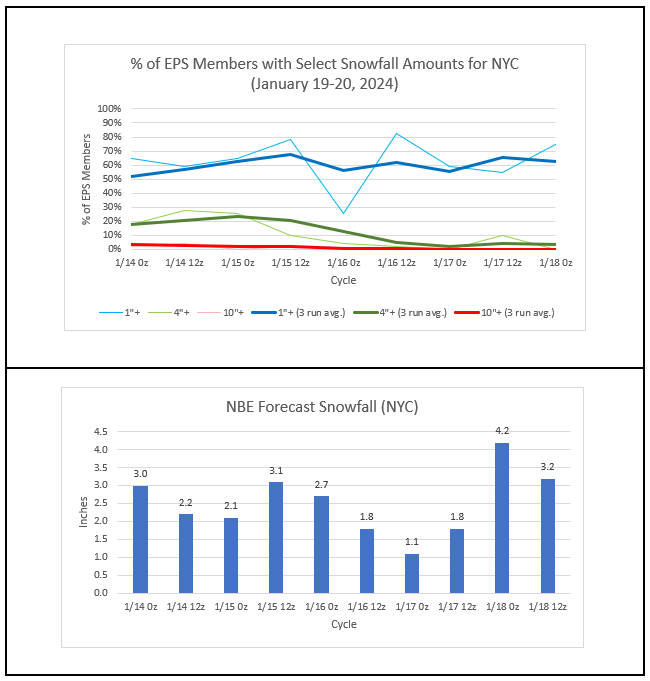
The temperature dipped to 17° this morning in Central Park. That was New York City's first reading below 20° this winter. It was also the fifth latest first teens on record. Another storm could impact the region Friday or Saturday. This again appears to be mainly a 1"-3" snow event for the New York City and Newark areas. However, there could be an area of moderate snow (generally around 4"). Ratios could be in the 12:1 to 15:1 range in many areas leading to a fluffier snow. Following the storm, the temperature will likely fall into the teens in New York City during the weekend, which will likely see this winter's coldest readings so far. Beyond that, a noticeable warming trend that could send temperatures well into the 40s across the region and even into the 50s in parts of the region will likely commence. This warm period will very likely assure that January will wind up as a warmer than normal month and Winter 2023-24 will become yet another warmer than normal winter in the New York City and Philadelphia areas. The ENSO Region 1+2 anomaly was +0.9°C and the Region 3.4 anomaly was +1.9°C for the week centered around January 10. For the past six weeks, the ENSO Region 1+2 anomaly has averaged +1.18°C and the ENSO Region 3.4 anomaly has averaged +1.95°C. A basinwide El Niño event is ongoing. The ongoing El Niño event has recently peaked. The SOI was +26.15 today. The preliminary Arctic Oscillation (AO) was -2.461 today. Strong blocking in the final week of November, as occurred this year, has often been followed by frequent blocking in December and January. On January 15 the MJO was in Phase 4 at an amplitude of 2.277 (RMM). The January 14-adjusted amplitude was 1.828 (RMM). Based on sensitivity analysis applied to the latest guidance, there is an implied 81% probability that New York City will have a warmer than normal January (1991-2020 normal). January will likely finish with a mean temperature near 35.6° (1.9° above normal).
-
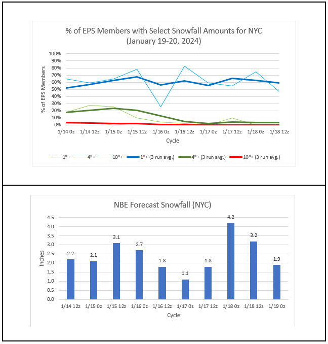
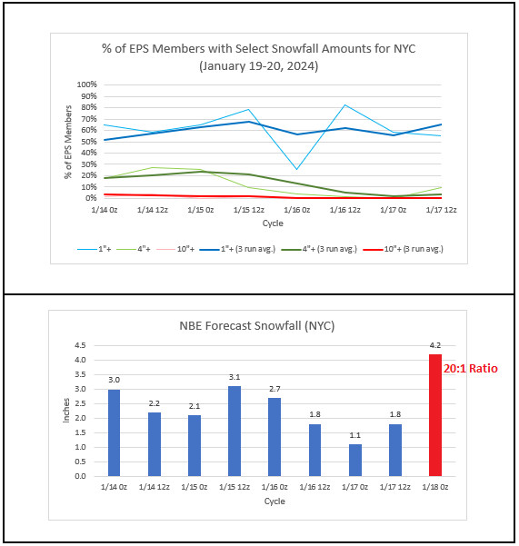
Although the specific amounts differ on the various models and exact details are not yet available with high confidence e.g., whether an inverted trough will develop and its placement, the overall theme is that this should be a relatively light event (1"-3"/2"-4"-type snowfall) for New York City, Newark, Philadelphia, and nearby areas. Ratios should be decent (12:1 to 15:1 generally), so if 0.15"-0.20" of precipitation falls, the region would generally see around 2"-3" of snow (at 15:1). Most of the 12z guidance is in that general ballpark with the NAM being a high outlier (for NYC). If one adjusts for the output that is based on 10:1 ratios, one would see the following from the 12z guidance for NYC (12:1 to 15:1 ratios): ECMWF: 1.0"-1.4" (low outlier) GFS: 1.7"-2.1" GGEM: 2.5"-3.2" ICON: 1.6"-2.0" NAM: 3.5"-4.4" (high outlier) RGEM: 2.2"-2.7" UKMET: 1.7"-2.1" Mean: 2.3" Standard Deviation: 0.9" The 1/17/2024 17z NBE shows 3.2" (on 0.16" precipitation or 20:1 ratio). That ratio is at the high-end of what typically occurs given the forecast temperatures. Even then, that solution would fall within the general kind of storm over which there is good model consensus. The WPC currently snows a minor event on its Day 3 map:
-
2.4" of snow fell at East Hills.
-
A quick note on ratios: Unlike with the January 6-7 storm that had above freezing temperatures throughout the duration of the storm in the New York City area and saw very low snow-to-liquid ratios, this storm will have above climatological ratios in the New York City area. From this far out, the soundings can still miss details necessary to really pin down the ratios. Nevertheless, looking at historic cases with a high temperature of 28°-32° and precipitation amounts of 0.05"-0.25" for the January 15-February 15 period in New York City's climate record, one can have confidence in higher ratios. There were 64 such cases since 1869. The mean snow-to-liquid ratio was 13.3:1. The median snow-to-liquid ratio was 12.5:1. Given the historic data and early soundings, my starting assumption is that the snow-to-liquid ratio for the upcoming storm will fall somewhere between 12:1 and 15:1. So, at this point my thinking is that this system will bring a general 1"-3"/2"-4"-type snowfall to New York City and Newark. As most of this snow will fall during the daytime on Friday, the record streak without 2" daily snowfall is likely to end.