donsutherland1
-
Posts
23,765 -
Joined
Content Type
Profiles
Blogs
Forums
American Weather
Media Demo
Store
Gallery
Everything posted by donsutherland1
-
Over the past 24 hours, the extended range guidance has turned cooler for much of the second half of September. As a result, September 2024 could wind up cooler than normal overall. Dry conditions will likely persist into late Tuesday. Afterward, moisture from the southeast will likely bring showers and periods of rain to the northern Mid-Atlantic region. Showers could persist into Friday. Total rainfall from late Tuesday into Friday should average about 0.50"-1.00" in an around New York City (lesser amounts to the north and east of the City) and 0.50"-1.50" in Philadelphia, Baltimore and Washington, DC. In terms of dry weather regionally, today is on track to become Boston's 26th consecutive day without measurable precipitation. That would be tied for the 6th longest dry stretch on record. Records go back to 1872. Some of the guidance brings light but measurable rainfall to Boston Wednesday or Thursday. The ENSO Region 1+2 anomaly was -0.4°C and the Region 3.4 anomaly was -0.1°C for the week centered around September 4. For the past six weeks, the ENSO Region 1+2 anomaly has averaged -0.30°C and the ENSO Region 3.4 anomaly has averaged -0.10°C. Neutral ENSO conditions will likely evolve into a La Niña event during the fall. The SOI was -9.62 today. The preliminary Arctic Oscillation (AO) was -1.030 today. Based on sensitivity analysis applied to the latest guidance, there is an implied 58% probability that New York City will have a cooler than normal September (1991-2020 normal). September will likely finish with a mean temperature near 68.8° (0.3° below normal).
- 1,154 replies
-
- 1
-

-
- tropics
- heavy rainfall
- (and 3 more)
-
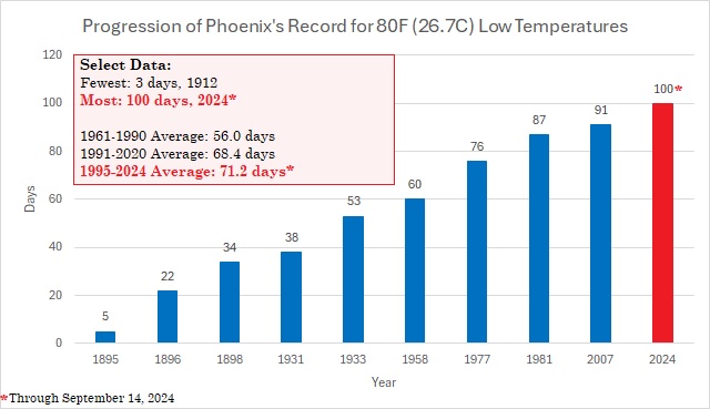
Yesterday, Phoenix recorded its 100th 80° low of the year, further extending its record. The combination of Urban Heat Island (UHI) Effect and ongoing anthropogenic warming has led to a dramatic explosion of the frequency of such hot nights.
-
The weekend got off to a pleasantly warm start. It will end with a continuation of the recent comfortable readings. High temperatures will be a few degrees cooler than they were today. Generally near normal to somewhat above normal temperatures will likely persist through the third week of September, if not longer. Excessive heat is unlikely. Dry conditions will likely persist into at least the middle of next week. Afterward, some moisture from the southeast could try to move into the area, but its progress northward remains somewhat uncertain given an expected strong ridge to the North. Nevertheless, some showers and perhaps periods of rain are possible, especially from New York City southward. Should the ridging wind up weaker than currently modeled, a more significant rainfall would be possible. In terms of dry weather regionally, today is on track to become Boston's 25th consecutive day without measurable precipitation. That would be tied for the 7th longest dry stretch on record. Records go back to 1872. The ENSO Region 1+2 anomaly was -0.4°C and the Region 3.4 anomaly was -0.1°C for the week centered around September 4. For the past six weeks, the ENSO Region 1+2 anomaly has averaged -0.30°C and the ENSO Region 3.4 anomaly has averaged -0.10°C. Neutral ENSO conditions will likely evolve into a La Niña event during the fall. The SOI was -2.91 today. The preliminary Arctic Oscillation (AO) was -1.212 today. Based on sensitivity analysis applied to the latest guidance, there is an implied 51% probability that New York City will have a warmer than normal September (1991-2020 normal). September will likely finish with a mean temperature near 69.3° (0.1° above normal).
-
Occasional Thoughts on Climate Change
donsutherland1 replied to donsutherland1's topic in Climate Change
The NOAA has an interactive map where one can look up sea rise scenarios up to the year 2100. https://coast.noaa.gov/slr/#/layer/slr/0/-8238447.1697526295/4970176.725736294/10/satellite/125/0.8/2050/interHigh/midAccretion One can look up local scenarios based on 2017 and 2022 projections. Afterward, one can also look up the degree of flooding at various locations based on the extent of sea level increase. Neither Miami nor New York City is projected to be underwater anytime soon. Even by 2100, at the high projection, much of NYC is not flooded. No serious climate scientist is calling for either city to be flooded in the near-term (next few decades). The incidence of flood events (sunny day and during storms is expected to increase). -
Generally near normal to somewhat above normal temperatures will likely persist through the third week of September, if not longer. Excessive heat appears unlikely. Dry conditions will likely persist into at least the middle of next week. Afterward, some moisture from the southeast could try to move into the area, but its progress northward remains uncertain given an expected strong ridge to the North. In terms of dry weather regionally, today is on track to become Boston's 24th consecutive day without measurable precipitation. That would be tied for the 8th longest dry stretch on record. Records go back to 1872. The ENSO Region 1+2 anomaly was -0.4°C and the Region 3.4 anomaly was -0.1°C for the week centered around September 4. For the past six weeks, the ENSO Region 1+2 anomaly has averaged -0.30°C and the ENSO Region 3.4 anomaly has averaged -0.10°C. Neutral ENSO conditions will likely evolve into a La Niña event during the fall. The SOI was -4.81 today. The preliminary Arctic Oscillation (AO) was -1.205 today. Based on sensitivity analysis applied to the latest guidance, there is an implied 54% probability that New York City will have a warmer than normal September (1991-2020 normal). September will likely finish with a mean temperature near 69.4° (0.2° above normal).
-
Generally near normal to somewhat above normal temperatures could persist through at least much of the third week of the month, if not longer. Excessive heat appears unlikely. Dry conditions will likely persist into at least the middle of next week. Afterward, some moisture from the southeast could try to move into the area, but its progress northward remains uncertain given an expected strong ridge to the North. In terms of dry weather regionally, today is on track to become Boston's 23rd consecutive day without measurable precipitation. That would be tied for the 9th longest dry stretch on record. Records go back to 1872. Out West, the pattern responsible for a record hot summer and torrid start to September continues to break down. A series of troughs and possible tropical moisture will move through the region over the next week or two bringing cooler conditions and the threat of rainfall. The ENSO Region 1+2 anomaly was -0.4°C and the Region 3.4 anomaly was -0.1°C for the week centered around September 4. For the past six weeks, the ENSO Region 1+2 anomaly has averaged -0.30°C and the ENSO Region 3.4 anomaly has averaged -0.10°C. Neutral ENSO conditions will likely evolve into a La Niña event during the fall. The SOI was -2.26 yesterday. The preliminary Arctic Oscillation (AO) was -0.791 today. Based on sensitivity analysis applied to the latest guidance, there is an implied 51% probability that New York City will have a warmer than normal September (1991-2020 normal). September will likely finish with a mean temperature near 69.3° (0.1° above normal).
-
The C3S appears to have a generally negative NAO during December, but it goes positive in January and February if the 500 mb height anomalies are reasonably accurate. A forecast weaker stratospheric polar vortex could facilitate at least periods of NAO-/AO-, if that forecast works out. At this range, there's still very high uncertainty.
- 1,154 replies
-
- 1
-
-
- tropics
- heavy rainfall
- (and 3 more)
-
Generally somewhat above normal to above normal temperatures could persist through at least much of the third week of the month, if not longer. However, excessive heat appears unlikely. Out West, the pattern responsible for a record hot summer and torrid start to September is beginning to break down as a series of troughs moves toward that region. The ENSO Region 1+2 anomaly was -0.4°C and the Region 3.4 anomaly was -0.1°C for the week centered around September 4. For the past six weeks, the ENSO Region 1+2 anomaly has averaged -0.30°C and the ENSO Region 3.4 anomaly has averaged -0.10°C. Neutral ENSO conditions will likely evolve into a La Niña event during the fall. The SOI was -2.26 today. The preliminary Arctic Oscillation (AO) was -0.142 today. Based on sensitivity analysis applied to the latest guidance, there is an implied 52% probability that New York City will have a warmer than normal September (1991-2020 normal). September will likely finish with a mean temperature near 69.3° (0.1° above normal).
-
A gradual warming trend is now underway. Exceptional warmth is unlikely through at least the first half of September. Generally somewhat above normal to above normal temperatures could persist through at least much of the third week of the month, if not longer. Out West, the pattern responsible for a record hot summer and torrid start to September should finally begin to break down late this week as a series of troughs moves through that region. The ENSO Region 1+2 anomaly was -0.4°C and the Region 3.4 anomaly was -0.1°C for the week centered around September 4. For the past six weeks, the ENSO Region 1+2 anomaly has averaged -0.30°C and the ENSO Region 3.4 anomaly has averaged -0.10°C. Neutral ENSO conditions will likely evolve into a La Niña event during the fall. The SOI was +6.24 today. The preliminary Arctic Oscillation (AO) was +0.140 today. Based on sensitivity analysis applied to the latest guidance, there is an implied 52% probability that New York City will have a warmer than normal September (1991-2020 normal). September will likely finish with a mean temperature near 69.4° (0.2° above normal).
-
Las Vegas Sees Its Hottest Summer on Record
donsutherland1 replied to donsutherland1's topic in Climate Change
Las Vegas reached 100° for the 100th day this year today. That tied the longstanding record for most such years that has stood since 1947. -
It's an initial run. Last year was quite skillful for North America, but not Eurasia (including Scandinavia). This year is TBD, especially as blocking (Atlantic and Pacific) is unknown from this far out. At this stage, I wouldn't lock it in. It's a point of interest. I suspect that the Great Lakes area should do well in terms of snowfall (normal or perhaps even somewhat above normal) even if the winter is mild overall. Consistent with numerous La Niña events, I suspect that the southern tier of the U.S. will be drier than normal. But these are emerging thoughts.
-
Occasional Thoughts on Climate Change
donsutherland1 replied to donsutherland1's topic in Climate Change
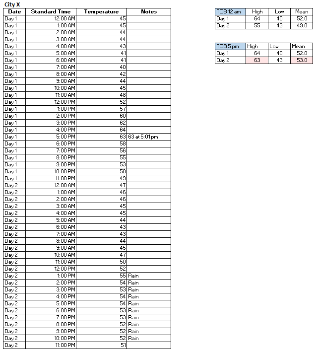
After asking around, as Martz blocked me, here's his argument for others to see: From his argument, it's clear that Martz does not understand time of observation bias (TOBS). TOBS does not result from COOP station observers not setting their minimum/maximum thermometers. It results from the time of observation. Hence, if a COOP observer resets his/her thermometer at 5 pm, the bias results from the time the thermometer is set, not from the failure to set it. Here's a quick illustration: Notice that the observer who resets at 5 pm has a higher reported maximum and mean temperature than if the standard 12 am-12am cycle were used. The observer was not incompetent. The observer set his/her thermometer on his/her schedule (5 pm). It was the time of observation, not observer competence, that made the difference. Were Martz's approach utilized, the biases resulting from time of observation--in this case a 4° difference for Day 2--would skew the data. If one wants an accurate climate record, the biases need to be removed.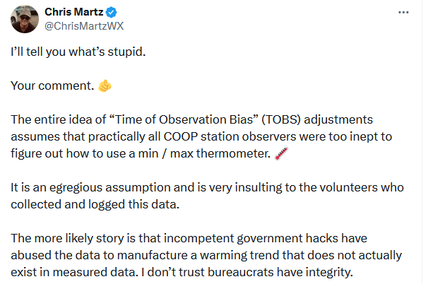
-
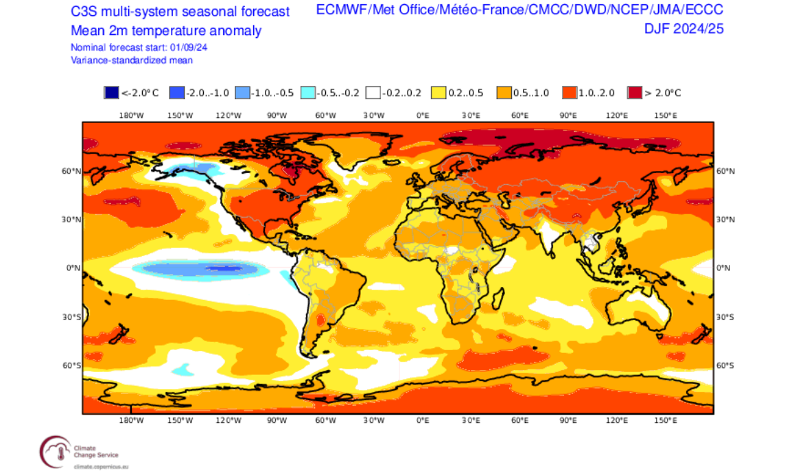
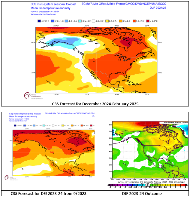
The C3S multi-model suite has come out with its first forecast for Winter 2024-2025. With an anticipated La Niña and strongly negative PDO state, there would typically be a tendency for ridging off the Southeast. Blocking forecasts from this far out have no skill, so that's a variable that could impact the forecast and outcome. The sample size of weak La Niña events following moderate to strong El Niño events is tiny. As a result, it makes sense to place greater weight on the seasonal guidance than usual. The C3S has done reasonably well with seasonal forecasting. Last September's outlook for Winter 2023-24 was quite good. Below is the initial winter forecast for North America on the C3S: Global December 2024-February 2025 Outlook:

- 1,154 replies
-
- 6
-

-

-

-

-
-
- tropics
- heavy rainfall
- (and 3 more)
-
Occasional Thoughts on Climate Change
donsutherland1 replied to donsutherland1's topic in Climate Change
This is another example of where Martz goes against accepted understanding in climate or meteorology. Time of Observation Bias (TOBS) is not a "supposed" phenomenon but a real one. TOBS has been documented in the literature as far back as the mid-1970s. https://journals.ametsoc.org/downloadpdf/view/journals/apme/14/4/1520-0450_1975_014_0471_eootom_2_0_co_2.pdf The adjustment to compensate for TOBS, which has been refined over the years, is not intended to skew temperatures, but to correct the climate record for the impact of TOBS. Martz may not see or understand the issue with using raw data as is, even where clearly-documented structural biases exist, but the the field of meteorology does. -
A gradual warming trend will commence tomorrow. Exceptional warmth is unlikely through at least the first half of September. The medium-range guidance has shifted toward an extended period of somewhat above to above normal temperatures. Therefore, once the warmth develops, above normal temperatures could persist through at least much of the third week of the month, if not longer. The ENSO Region 1+2 anomaly was -0.4°C and the Region 3.4 anomaly was -0.1°C for the week centered around September 4. For the past six weeks, the ENSO Region 1+2 anomaly has averaged -0.30°C and the ENSO Region 3.4 anomaly has averaged -0.10°C. Neutral ENSO conditions will likely evolve into a La Niña event during the fall. The SOI was -0.53 today. The preliminary Arctic Oscillation (AO) was +0.275 today. Based on sensitivity analysis applied to the latest guidance, there is an implied 51% probability that New York City will have a warmer than normal September (1991-2020 normal). September will likely finish with a mean temperature near 69.4° (0.2° above normal).
- 1,154 replies
-
- 1
-
-
- tropics
- heavy rainfall
- (and 3 more)
-
The first week of September proved cooler than normal in the East. Parts of the West saw their hottest first week of September and hottest 7-day period so late in the season. Records were set in cities including Blythe, Palm Springs, and Phoenix. Parts of the New York City and Philadelphia regions could again see their coolest temperatures so far this fall tomorrow morning. However, a gradual warming trend will likely commence on Tuesday. The medium-range guidance has shifted toward an extended period of somewhat above to above normal temperatures. Therefore, once the warmth develops, above normal temperatures could persist through at least much of the third week of the month, if not longer. The ENSO Region 1+2 anomaly was -0.5°C and the Region 3.4 anomaly was -0.2°C for the week centered around August 28. For the past six weeks, the ENSO Region 1+2 anomaly has averaged -0.35°C and the ENSO Region 3.4 anomaly has averaged -0.07°C. Neutral ENSO conditions will likely evolve into a La Niña event during the fall. The SOI was -7.25 today. The preliminary Arctic Oscillation (AO) was +0.388 today. Based on sensitivity analysis applied to the latest guidance, there is an implied 54% probability that New York City will have a warmer than normal September (1991-2020 normal). September will likely finish with a mean temperature near 69.6° (0.4° above normal).
-
Gulf Stream to Shut Down this Century
donsutherland1 replied to 40/70 Benchmark's topic in Climate Change
I hope this new study is accurate, but I want to see more given that it seems to be somewhat of an outlier among the recent literature. So far, Dr. Stefan Ramstorf, who has studied AMOC extensively, has not yet commented. -
A strong cold front is pushing across the region with heavy showers. Already, the temperature has fallen from a high of 75° to 63°. In its wake, much of the regon will see its coolest night so far this season. By morning, New York City will see the temperature in the low 50s. Many areas outside the City will experience readings in the 40s. Tomorrow, the mercury will struggle to reach 70° in the New York City area. Some areas could top out in the upper 60s. Parts of the region could again see their coolest temperatures so far this fall on Monday morning. A warming trend will likely develop early next week. Afterward, the guidance has shifted toward an extended period of somewhat above to above normal temperatures. The ENSO Region 1+2 anomaly was -0.5°C and the Region 3.4 anomaly was -0.2°C for the week centered around August 28. For the past six weeks, the ENSO Region 1+2 anomaly has averaged -0.35°C and the ENSO Region 3.4 anomaly has averaged -0.07°C. Neutral ENSO conditions will likely evolve into a La Niña event during the fall. The SOI was -5.82 today. The preliminary Arctic Oscillation (AO) was +0.822 today. Based on sensitivity analysis applied to the latest guidance, there is an implied 54% probability that New York City will have a warmer than normal September (1991-2020 normal). September will likely finish with a mean temperature near 69.6° (0.4° above normal).
- 1,154 replies
-
- 2
-
-
-
- tropics
- heavy rainfall
- (and 3 more)
-
Occasional Thoughts on Climate Change
donsutherland1 replied to donsutherland1's topic in Climate Change
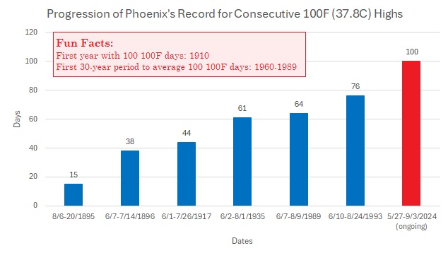
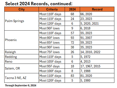
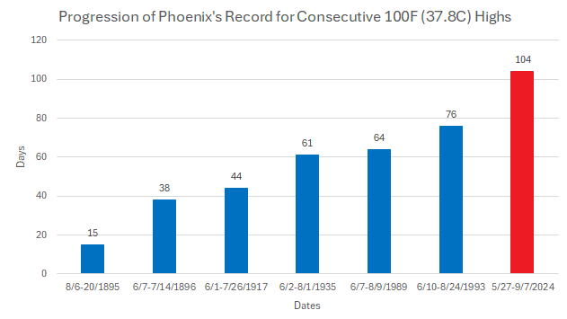
Following among their hottest summers on record (particularly in the West), numerous locations have exceeded annual records for a variety of hot weather metrics: In addition, through September 6th, six locations had ongoing streaks of 100 more consecutive days with 100° or above high temperatures: Blythe, East Mesa, Needles, Phoenix, Tacna 3 NE, and Yuma. On September 7th, Phoenix's streak reached 104 consecutive days, which is four weeks longer than the previous record. East Mesa and Phoenix are the first U.S. population centers with 500,000 or more people to record such a streak. Summer Rank: Baltimore: 4th hottest Bishop: 2nd hottest Blythe: Hottest on record Boise: 2nd hottest Daggett: Hottest on record Fresno: 2nd hottest Las Vegas: Hottest on record Needles: Hottest on record Palm Springs: Hottest on record Phoenix: Hottest on record Raleigh: 3rd hottest on record Redding: Hottest on record Reno: Hottest on record Salem: 3rd hottest on record Tacna 3 NE, AZ: Hottest on record Anthropogenic climate change has made the above outcomes more likely. The Urban Heat Island (UHI) Effect has amplified the impacts of climate change.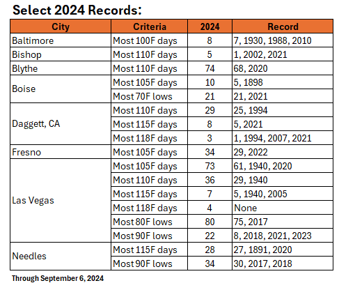
-
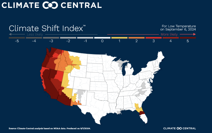
On September 5, Phoenix recorded a September record-tying 116° high temperature. A day later, Phoenix followed up with a new September monthly record high minimum temperature of 93°, which broke the old record by 2°. In California, Palm Springs recorded a low temperature of 95°, beating the September monthly mark by 3°. That was also tied for the second highest low temperature on record. According to Climate Central's Climate Shift Index, this warmth was made at least 5 times more likely due to climate change.
-
Another autumnal air mass will move into the region this weekend. Showers are possible tomorrow as a strong cold front pushes across the region. In its wake, the mercury will struggle to reach 70° in the New York City area on Sunday. Parts of the region will also see their coolest temperatures so far this fall on Sunday and/or Monday morning. Overall, the first week of September will likely wind up somewhat cooler than normal. A ridge in the West, trough in the East pattern could persist into the second week of the month allowing for additional cooler than normal days. However, a warming trend could develop early next week. As a result of the persistent Western ridging, parts of the West that just went through their hottest summer on record could remain abnormally warm through the first half of the month. Phoenix (93°) and Palm Springs (95°) were on track to record their highest minimum temperatures on record for September. Phoenix also reached 110° for its record 57th day this year. The ENSO Region 1+2 anomaly was -0.5°C and the Region 3.4 anomaly was -0.2°C for the week centered around August 28. For the past six weeks, the ENSO Region 1+2 anomaly has averaged -0.35°C and the ENSO Region 3.4 anomaly has averaged -0.07°C. Neutral ENSO conditions will likely evolve into a La Niña event during the fall. The SOI was +1.84 today. The preliminary Arctic Oscillation (AO) was +0.434 today.
- 1,154 replies
-
- 2
-
-
- tropics
- heavy rainfall
- (and 3 more)
-
Another comfortable day lies ahead for tomorrow. Temperatures will again top out in the middle and upper 70s. Showers are possible on Saturday as a strong cold front pushes across the region. In its wake, the mercury will struggle to reach 70° in the New York City area on Sunday. Overall, the first week of September will likely wind up somewhat cooler than normal. A ridge in the West, trough in the East pattern could persist into the second week of the month allowing for additional cooler than normal days. However, a warming trend could develop early next week. As a result of the persistent Western ridging, parts of the West that just went through their hottest summer on record could remain abnormally warm through the first half of the month. Today, Phoenix extended its record 100° streak to 102 days. It also reached 110° or above for the 56th day this year. That breaks the record of 55 days from 2023. The ENSO Region 1+2 anomaly was -0.5°C and the Region 3.4 anomaly was -0.2°C for the week centered around August 28. For the past six weeks, the ENSO Region 1+2 anomaly has averaged -0.35°C and the ENSO Region 3.4 anomaly has averaged -0.07°C. Neutral ENSO conditions will likely evolve into a La Niña event during the fall. The SOI was +0.068 today. The preliminary Arctic Oscillation (AO) was -0.247 today.
- 1,154 replies
-
- 2
-
-
- tropics
- heavy rainfall
- (and 3 more)
-
After a cool start, temperatures again rose into the pleasant 70s across the region. Much of this week will feature refreshing temperatures and low humidity. Temperatures will mainly top out in the middle and upper 70s. Fair weather should persist through Friday. Showers are possible on Saturday. Overall, the first week of September will likely wind up somewhat cooler than normal. A ridge in the West, trough in the East pattern could persist into the second week of the month allowing for additional cooler than normal days. As a result, parts of the West that just went through their hottest summer on record could remain abnormally warm through the first half of the month. As extreme heat spreads back into the Pacific Northwest starting tomorrow, Portland could tie or break its record for latest 100° day on record. Salem will likely reach 100° on one or two days, which would break the annual record of 7 100° or above days that was set in 1988. Phoenix reached 111°, its record-tying 55th 110° day. Palm Springs topped out at 116°, its record-tying 23rd 115° day. The ENSO Region 1+2 anomaly was -0.5°C and the Region 3.4 anomaly was -0.2°C for the week centered around August 28. For the past six weeks, the ENSO Region 1+2 anomaly has averaged -0.35°C and the ENSO Region 3.4 anomaly has averaged -0.07°C. Neutral ENSO conditions will likely evolve into a La Niña event during the fall. The SOI was +5.23 today. The preliminary Arctic Oscillation (AO) was -0.247 today.
-
While the West continues to fry, the East continues to enjoy comfortable temperatures. Much of this week will feature refreshing temperatures and low humidity. Temperatures will mainly top out in the middle and upper 70s. Fair weather should persist through Friday. Showers are possible on Saturday. Overall, the first week of September will likely wind up somewhat cooler than normal. A ridge in the West, trough in the East pattern could persist into the second week of the month allowing for additional cooler than normal days. As a result, parts of the West that just went through their hottest summer on record could remain abnormally warm through the first half of the month. As extreme heat spreads back into the Pacific Northwest starting tomorrow, Portland could tie or break its record for latest 100° day on record. Salem will likely reach 100° on one or two days, which would break the annual record of 7 100° or above days that was set in 1988. Today, Phoenix reached 100° for the 100th consecutive day. The old record was 76 days. Blythe, East Mesa, and Needles also recorded their 100th consecutive 100° day. Phoenix is, by far, the largest U.S. city ever to experience such a streak. East Mesa is the second largest. The ENSO Region 1+2 anomaly was -0.5°C and the Region 3.4 anomaly was -0.2°C for the week centered around August 28. For the past six weeks, the ENSO Region 1+2 anomaly has averaged -0.35°C and the ENSO Region 3.4 anomaly has averaged -0.07°C. Neutral ENSO conditions will likely evolve into a La Niña event during the fall. The SOI was +4.99 today. The preliminary Arctic Oscillation (AO) was -0.300 today.
- 1,154 replies
-
- 4
-
-
-
- tropics
- heavy rainfall
- (and 3 more)