donsutherland1
-
Posts
23,765 -
Joined
Content Type
Profiles
Blogs
Forums
American Weather
Media Demo
Store
Gallery
Everything posted by donsutherland1
-
I agree regarding the Continent. Yaakov's tweet referenced the Northeast.
-
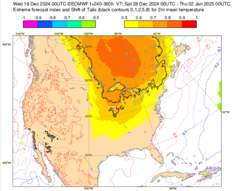
The "torch" will be in the vicinity of the Hudson and James Bays. The days 10-15 EFI does well in highlighting the risk. The Northeast and Great Lakes will probably be on the mild side of normal but widespread record-challenging warmth doesn't appear likely at this time in most of the CONUS. Wisconsin and Minnesota could see records challenged.
-
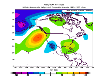
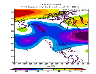
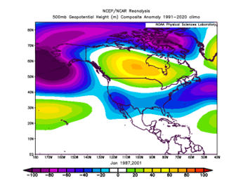
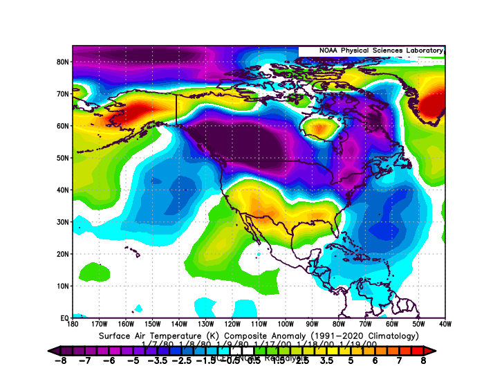
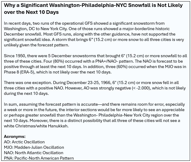
Clouds gave way to sunshine and the temperature surged into the upper 50s and lower 60s across much of the Northeast. In places, the temperature approached daily records. Highs included: Atlantic City: 619 Baltimore: 64° Bangor: 57° Boston: 60° Caribou: 50° Hartford: 60° Islip: 60° New York City-Central Park: 59° New York City-JFK Airport: 58° New York City-LaGuardia Airport: 60° Newark: 61° Philadelphia: 63° Portland: 56° Providence: 61° Richmond: 71° Washington, DC: 65° (tied record set in 2021) A cooling trend will commence tomorrow. A much sharper shot of cold will then aarive during the weekend. The potential exists for the temperature to fall into the teens for the first time this season in New York City. In addition, a system will likely bring some periods of light snow to the region late Friday into early Saturday morning. A minor accumulation is possible in the Philadelphia to New York City region. The potential exists for a 1"-3"/2"-4" snowfall in the Boston area. Beyond that, the pattern will likely remain changeable through much of the rest of the month on account of a fast jet stream. December will likely close with above normal temperatures and January will likely see at least its opening days turn out milder than normal. In past days, an occasional run of the operational GFS showed a significant snowstorm from Washington, DC to New York City. However, the pattern makes such an event very unlikely for this region. Since 1950, there were 5 December snowstorms that brought 6" or more snow to all three of these cities. Four (80%) occurred with a PNA+/NAO- pattern. The NAO is forecast to be positive. In addition, three (60%) occurred when the MJO was in Phase 8, which is not likely over the next 10 days. Only the December 23-25, 1966 event produced 6" or more snow in all three cities with a positive NAO, but the AO was strongly negative (< -2.000), which is not likely during the next 10 days. In sum, the interior sections will be far more favored for an appreciable or perhaps greater snowfall than the Washington-Baltimore-Philadelphia-New York City area over the next 10 days. A smaller snowfall remains plausible. The NAO fell to a preliminary -2.751 on September 24th (all-time September record: -2.371, September 12, 1971). That was the 9th lowest value on record. La Niña winters following September cases where the NAO fell to -1.900 or below featured a predominantly positive NAO. The most recent such winters were 2016-2017 and 2022-2023. The mean temperatures for those winters in New York City were 39.3° and 41.0° respectively. The 1991-2020 normal value is 36.2°. A warmer to much warmer than normal outcome is favored by the November run of the ECMWF for Winter 2024-2025. The ENSO Region 1+2 anomaly was -0.2°C and the Region 3.4 anomaly was -0.6°C for the week centered around December 11. For the past six weeks, the ENSO Region 1+2 anomaly has averaged +0.17°C and the ENSO Region 3.4 anomaly has averaged -0.27°C. Neutral ENSO conditions may still evolve into a La Niña event during the winter. Uncertainty as to whether a La Niña will actually develop continues to increase. Currently, 47% of dynamical models and 22% of the statistical models forecast the development of a La Niña. The SOI was +9.76 today. The preliminary Arctic Oscillation (AO) was +0.109 today. Based on sensitivity analysis applied to the latest guidance, there is an implied 80% probability that New York City will have a colder than normal December (1991-2020 normal). December will likely finish with a mean temperature near 37.0° (2.1° below normal).
-
Areas well to the north and west of New York City saw some snow and freezing rain this morning as warmer air pushed northward. New York City and its nearby suburbs saw only rain. Milder air has now returned to the region. The peak warmth will be shortlived. It will be unseasonably mild tomorrow with temperatures rising mainly into the upper 50s and perhaps even the lower 60s. Additional rain is likely, as well. Following the rain, it will again turn somewhat colder before a much sharper shot of cold arrives for during or after the next weekend. The potential exists for the temperature to fall into the teens for the first time this season in New York City. Beyond that, the pattern will likely remain changeable through much of the rest of the month on account of a fast jet stream. December will likely close with above normal temperatures and January will likely see at least its opening days turn out milder than normal. In past days, an occasional run of the operational GFS showed a significant snowstorm from Washington, DC to New York City. However, the pattern makes such an event very unlikely for this region. Since 1950, there were 5 December snowstorms that brought 6" or more snow to all three of these cities. Four (80%) occurred with a PNA+/NAO- pattern. The NAO is forecast to be positive. In addition, three (60%) occurred when the MJO was in Phase 8, which is not likely over the next 10 days. Only the December 23-25, 1966 event produced 6" or more snow in all three cities with a positive NAO, but the AO was strongly negative (< -2.000), which is not likely during the next 10 days. In sum, the interior sections will be far more favored for an appreciable or perhaps greater snowfall than the Washington-Baltimore-Philadelphia-New York City area over the next 10 days. A smaller snowfall remains plausible. One possible light snowfall could occur late Friday into Saturday morning. Any accumulations would be minor in and around the New York City area. The NAO fell to a preliminary -2.751 on September 24th (all-time September record: -2.371, September 12, 1971). That was the 9th lowest value on record. La Niña winters following September cases where the NAO fell to -1.900 or below featured a predominantly positive NAO. The most recent such winters were 2016-2017 and 2022-2023. The mean temperatures for those winters in New York City were 39.3° and 41.0° respectively. The 1991-2020 normal value is 36.2°. A warmer to much warmer than normal outcome is favored by the November run of the ECMWF for Winter 2024-2025. The ENSO Region 1+2 anomaly was -0.2°C and the Region 3.4 anomaly was -0.6°C for the week centered around December 11. For the past six weeks, the ENSO Region 1+2 anomaly has averaged +0.17°C and the ENSO Region 3.4 anomaly has averaged -0.27°C. Neutral ENSO conditions may still evolve into a La Niña event during the winter. Uncertainty as to whether a La Niña will actually develop continues to increase. Currently, 47% of dynamical models and 22% of the statistical models forecast the development of a La Niña. The SOI was +7.21 today. The preliminary Arctic Oscillation (AO) was +1.003 today. Based on sensitivity analysis applied to the latest guidance, there is an implied 85% probability that New York City will have a colder than normal December (1991-2020 normal). December will likely finish with a mean temperature near 36.7° (2.4° below normal).
-
Considering the warmth of the Week 3 outlook and snap back on the Week 6 outlook, it's possible that the coldest period might be right around the days leading up to and then following January 13th.
-
This is happening more and more frequently as winters continue to warm. The Arctic shot next weekend/early next week will probably bring an end to the blooms.
-
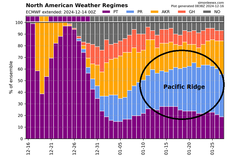
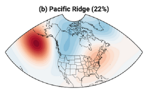
The ECMWF is indicating that a Pacific Ridge pattern could develop toward mid-January. If so, any cold that develops during the first week of January could last 1-2 weeks before a warmer pattern begins to develop, assuming that the ECMWF is correct. Recent ECMWF ensemble 46-day forecasts suggested that a PNA- pattern could develop approaching mid-January, so the outcome above is a plausible scenario. Fortunately, all of that remains well in the future, so significant changes are possible.
-
Final weekly outcome:


-
Yes. The 1991-20 baseline is quite a bit warmer than the 1981-10 one.
-
New York City, Philadelphia, and Washington, DC have seen their coldest December 1-15 period since 2010. Boston has seen its coldest such period since 2013. Baltimore saw its coldest since 2017. Despite the cold, snowfall has been lacking. As a result, Boston has now gone 1,024 consecutive days without a 4" or greater daily snowfall (old record: 711 days). Richmond has gone 1,064 days without a 1" or above daily snowfall (old record: 725 days). Significant snowfall remains unlikely in this region for the foreseeable future. Much milder air will return starting tomorrow. It will be unseasonably mild tomorrow and Tuesday. Additional rain is likely, as well. Following the rain, it will again turn somewhat colder before a much sharper shot of cold arrives for during or after the next weekend. The potential exists for the temperature to fall into the teens for the first time this season in New York City. Beyond that, the pattern will likely remain changeable through much of the rest of the month on account of a fast jet stream. The probability of a mild end to the month and mild start for the first few days of January has increased. In recent days, an occasional run of the operational GFS showed a significant snowstorm from Washington, DC to New York City. However, the pattern makes such an event very unlikely for this region. Since 1950, there were 5 December snowstorms that brought 6" or more snow to all three of these cities. Four (80%) occurred with a PNA+/NAO- pattern. The NAO is forecast to be positive. In addition, three (60%) occurred when the MJO was in Phase 8, which is not likely over the next 10 days. Only the December 23-25, 1966 event produced 6" or more snow in all three cities with a positive NAO, but the AO was strongly negative (< -2.000), which is not likely during the next 10 days. In sum, the interior sections will be far more favored for an appreciable or perhaps greater snowfall than the Washington-Baltimore-Philadelphia-New York City area over the next 10 days. A smaller snowfall is plausible. The NAO fell to a preliminary -2.751 on September 24th (all-time September record: -2.371, September 12, 1971). That was the 9th lowest value on record. La Niña winters following September cases where the NAO fell to -1.900 or below featured a predominantly positive NAO. The most recent such winters were 2016-2017 and 2022-2023. The mean temperatures for those winters in New York City were 39.3° and 41.0° respectively. The 1991-2020 normal value is 36.2°. A warmer to much warmer than normal outcome is favored by the November run of the ECMWF for Winter 2024-2025. The ENSO Region 1+2 anomaly was +0.1°C and the Region 3.4 anomaly was -0.3°C for the week centered around December 4. For the past six weeks, the ENSO Region 1+2 anomaly has averaged +0.12°C and the ENSO Region 3.4 anomaly has averaged -0.20°C. Neutral ENSO conditions may still evolve into a La Niña event during the winter. Uncertainty as to whether a La Niña will actually develop continues to increase. Currently, 47% of dynamical models and 22% of the statistical models forecast the development of a La Niña. The SOI was +0.52 today. The preliminary Arctic Oscillation (AO) was +1.573 today. Based on sensitivity analysis applied to the latest guidance, there is an implied 83% probability that New York City will have a colder than normal December (1991-2020 normal). December will likely finish with a mean temperature near 36.9° (2.2° below normal).
-
It probably won't be as impressive as 2022, which saw two single-digit lows and a high temperature of just 15° on December 24th in NYC. It will still be fairly impressive.
-
The ECMWF has had this cold shot for several days with the temperature falling into the middle teens in NYC. We'll whether this run is actually colder once the higher-resolution figures come out on Wxmodels or Wxbell. Regardless, this will likely be December's strongest cold shot.
-
Almost certainly, it was a turboprop and the red lights were beacon lights. Westchester County Airport has a lot of turboprop air traffic (mostly corporate planes). To be sure, there are some drones being flown. One story: https://www.cnn.com/2024/12/15/us/drone-boston-airport-arrest/index.html
-
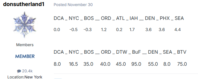
I'm leaning somewhat warmer than normal for NYC, Philadelphia, Washington, DC, Chicago. The exact values will be posted on 12/31 and I can change my mind based on the latest guidance. Putting ideas for January out on December 15th ignores the stochastic changes that can occur. My final idea will be posted in the January forecast contest. My December thinking is below (temperatures in the first set of numbers and seasonal snowfall for the second set of numbers):
-
Yesterday, I noted that the 46-day ECMWF ensembles show the development of an EPO-/PNA- pattern during the first half of January. Statistically, following a PNA+ December, a PNA- January is uncommon: December PNA: +0.5 or above: 31 cases January PNA < 0: 29% cases January PNA > 0: 71% cases January PNA +0.50 or above: 48% cases January PNA +1.00 or above: 19% cases Lowest January PNA: -1.14, 1954 Highest January PNA: 2.02, 2016 December PNA: +1.00 or above: 13 cases January PNA < 0: 8% cases January PNA > 0: 92% cases January PNA +0.50 or above: 62% cases January PNA +1.00 or above: 31% cases Lowest January PNA: -1.14, 1954 Highest January PNA: +1.51, 2001 If one assumes that the PNA will average > 0 during January, especially as the December PNA could average near or even slightly above +1.00, the idea of a predominant ridge in the West and trough in the East pattern with warmth in the West and cold in the East is not anything close to a slam dunk. The predominant patterns show a wide range of diversity. Trough in the West Patterns: 42% of cases Ridge in the West Patterns: 33% of cases Trough across much of the CONUS: 25% of cases The classic ridge in the West, trough in the East pattern has occurred with mean January PNA values -0.95 or below, as did the second type of trough across the CONUS cluster (most were +1.00 or above). All of the other clusters had mean January PNA values below -0.75. The first trough in the West, ridge in the East pattern actually produces a temperature anomaly pattern that is very similar to an EPO-/PNA- pattern. Overall, even if one assumes a predominantly positive PNA for January, which would go against the 46-day ECMWF guidance, one can't automatically assume that the eastern third or half of the U.S. would wind up colder than normal. Keeping in mind the 3-month seasonal guidance, which is more skillful than the month-by-month guidance over seasonal timeframes, a milder January outcome may be somewhat more likely than a colder one for the eastern third or half of the CONUS and southeastern Canada (Ontario and Quebec). There will likely be variability, which has been an important theme through December 14th and is likely to continue throughout the month based on a consensus of the latest guidance.

-
Post on a neighborhood forum: “OK...SERIOUSLY!!! I just saw the car-sized drone fly over my house in White Plains, NY. I am close to the corner of Davis Avenue and Prospect Street. It had red flashing lights, and was making a pretty loud humming sound.” Little does he know, there’s a drone base aka Westchester County Airport, nearby.
-
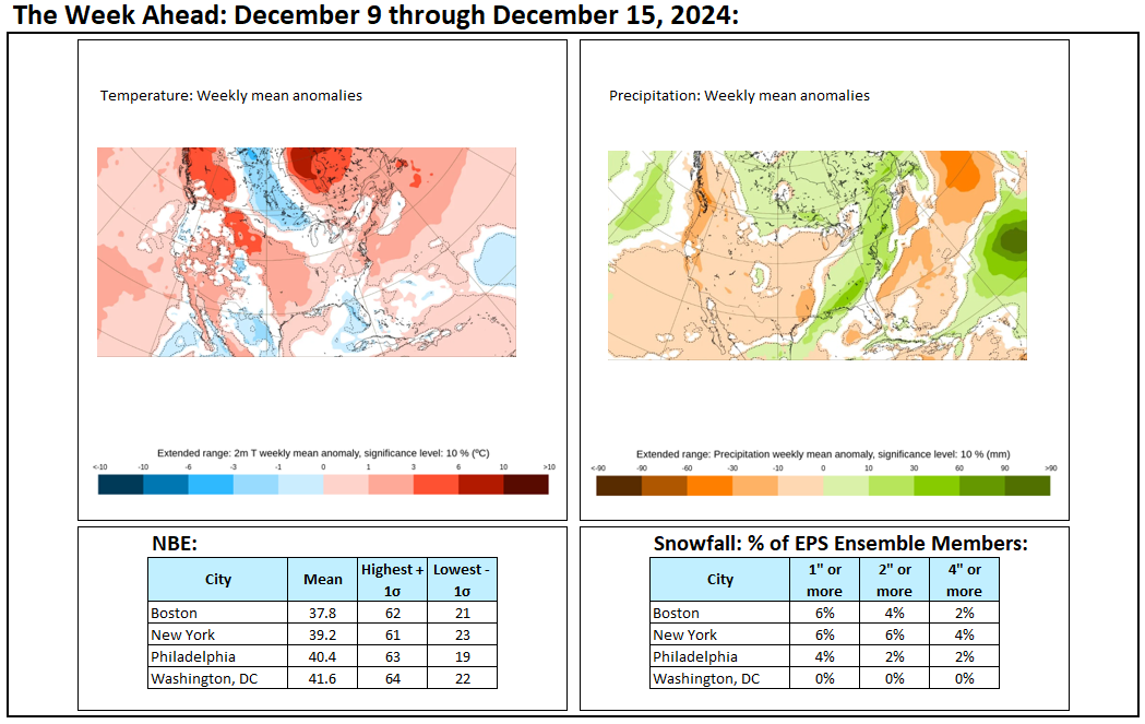
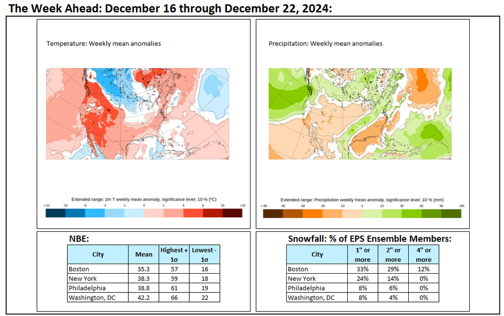
The week ahead. Some interior snowfalls, but no significant East Coast snowfalls from Washington to Boston are likely. The period will start off very mild but end with perhaps the coldest weather so far this season moving into the region.
-
Today was another cold day. The cold will last through the weekend before milder air returns early next week. It could then turn unseasonably mild for a time. Additional rain is possible early next week. Following the rain, it will again turn somewhat colder before a much sharper shot of cold arrives for during or after the next weekend. The potential exists for the temperature to fall into the teens for the first time this season in New York City. Beyond that, the pattern will likely remain changeable through much of the rest of the month on account of a fast jet stream. The overall anomaly for the final week of the month is unusually uncertain with most of the ensemble guidance and the weekly guidance in disagreement. However, the probability of a mild end to the month and mild start for the first few days of January has increased. In recent days, an occasional run of the operational GFS showed a significant snowstorm from Washington, DC to New York City. However, the pattern makes such an event very unlikely for this region. Since 1950, there were 5 December snowstorms that brought 6" or more snow to all three of these cities. Four (80%) occurred with a PNA+/NAO- pattern. The NAO is forecast to be positive. In addition, three (60%) occurred when the MJO was in Phase 8, which is not likely over the next 10 days. Only the December 23-25, 1966 event produced 6" or more snow in all three cities with a positive NAO, but the AO was strongly negative (< -2.000), which is not likely during the next 10 days. In sum, the interior sections will be far more favored for an appreciable or perhaps greater snowfall than the Washington-Baltimore-Philadelphia-New York City area over the next 10 days. A smaller snowfall is plausible. The NAO fell to a preliminary -2.751 on September 24th (all-time September record: -2.371, September 12, 1971). That was the 9th lowest value on record. La Niña winters following September cases where the NAO fell to -1.900 or below featured a predominantly positive NAO. The most recent such winters were 2016-2017 and 2022-2023. The mean temperatures for those winters in New York City were 39.3° and 41.0° respectively. The 1991-2020 normal value is 36.2°. A warmer to much warmer than normal outcome is favored by the November run of the ECMWF for Winter 2024-2025. The ENSO Region 1+2 anomaly was +0.1°C and the Region 3.4 anomaly was -0.3°C for the week centered around December 4. For the past six weeks, the ENSO Region 1+2 anomaly has averaged +0.12°C and the ENSO Region 3.4 anomaly has averaged -0.20°C. Neutral ENSO conditions may still evolve into a La Niña event during the winter. Uncertainty as to whether a La Niña will actually develop continues to increase. Currently, 47% of dynamical models and 22% of the statistical models forecast the development of a La Niña. The SOI was +3.32 today. The preliminary Arctic Oscillation (AO) was +0.817 today. Based on sensitivity analysis applied to the latest guidance, there is an implied 78% probability that New York City will have a colder than normal December (1991-2020 normal). December will likely finish with a mean temperature near 37.2° (1.9° below normal).
-
The cold should be coming. It might be delayed somewhat. The ECMWF weeklies grew more aggressive. The CFSv2 weeklies have not. I suspect that we'll see variations of both the clusters I posted earlier.
-
In terms of snowfall over the next 10-14 days, the GGEM might offer a reasonable good case scenario for the immediate NYC area. IMO, trying to envision a significant or major storm ignores the reality of the forecast pattern. Interior sections continue to have the best chance of seeing a moderate snowfall. Some changes to the forecast pattern are still possible, but really substantial changes would be needed for there to be a blockbuster storm. Consider how many times big maps are posted on Social Media. Only a small number actually verify. Posting aggressive maps while ignoring the overall forecasting environment sets one up for a high probability of failure.
-
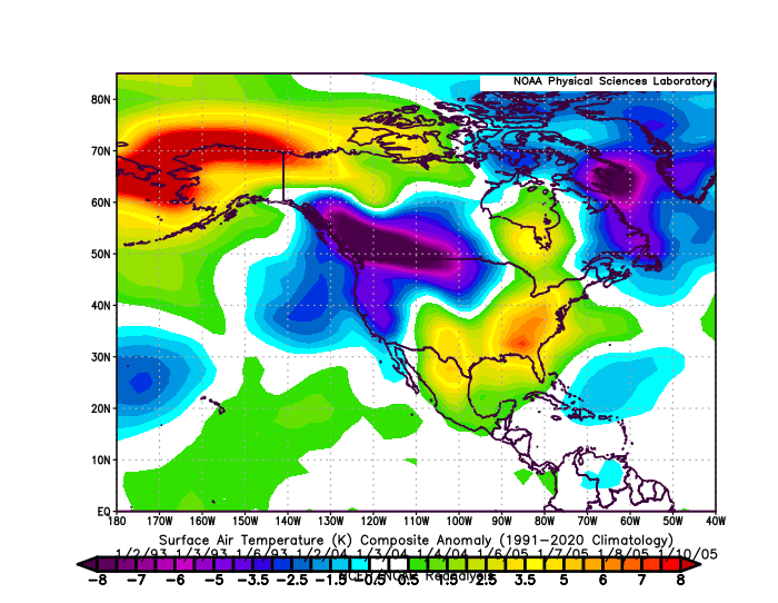
Some updates on last week's thoughts: 1. Warmer air surged back into the northern Mid-Atlantic and southern New England regions earlier this week. Highs included: Baltimore: 64°, Boston: 62°; Hartford: 64°; Islip; 60°; New York City: 60°; Newark: 63°; Philadelphia: 64°; Providence: 61°; and, Washington, DC: 64° 2. A significant rainstorm affected the northern Mid-Atlantic and southern New England areas Tuesday into Wednesday. Rainfall amounts included: Baltimore: 0.92"; Boston: 2.82"; Hartford: 1.54"; Islip: 1.69"; Newark: 0.92"; New York City: 1.11"; Philadelphia: 0.98"; Providence: 4.64"; and, Washington, DC: 0.95". The Wednesday (December 11) rainfall of 4.60" at Providence was the highest daily rainfall on record there from the October 6 through March 29 period. 3. Frigid temperatures affected parts of the North Central and Great Lakes regions. Lowest temperatures for select cities included: Chicago: 4° (2 consecutive days); Detroit: 10°; Milwaukee: 2°; and Minneapolis: -7° (3 consecutive subzero lows). 4. Phoenix saw the mercury rebound into the 70s. As of December 13th, Phoenix is on track for an annual mean temperature of 78.4°, which would make 2024 that city's warmest year on record. 5. The probability that numerous locations in the eastern third of the U.S. will feature a colder than normal December has increased further. There is currently an implied 78% probability that New York City will have a colder than normal December. Three thoughts going forward: 1. The changeable weather will continue from the Great Lakes region to the Northeast. The temperature could rocket to much above normal levels early next week. The temperature could reach 50° or above in Detroit and reach the upper 50s in New York City and Philadelphia and likely the 60s in Baltimore and Washington, DC. The week could end with a return to colder conditions. 2. Despite periodic hints of a significant snowfall from Washington, DC to New York City on the operational GFS, any snowfall threat will largely favor interior cities. No significant snowfall appears likely from Washington, DC to New York City given the NAO+ pattern and fast Pacific flow. Even cities such as Chicago, Detroit, and Toronto likely won't see much snowfall next week. 3. As the ongoing PNA+ persists, readings could rise to above normal levels in such cities as Portland and Seattle. Phoenix will see another very warm week. Long-Range: The changeable pattern will continue through the end of December. A sharp cold shot could affect the eastern third of the U.S. around or just after the Winter Solstice. Milder air will then overspread the region several days later and the remainder of December now looks to be generally mild. In addition, the combination of a continuing fast Pacific flow and NAO+ makes prospects for a big East Coast snowstorm unlikely over at least the next 10-14 days. The recent long-range guidance (extended GEFS, ECMWF weeklies, and CFSv2 weeklies) has now reached a consensus that January will start on a warmer than normal note across much of the CONUS and southern Canada. The transition to a possible colder pattern is delayed, but still shows up. The extended range 46-day ECMWF teleconnections forecast shows the development of an EPO-/PNA- pattern for at least the first half of January. There are two major clusters of outcomes from such a pattern: Cluster 1: 62.5% of cases: Cluster 2: 37.5% cases: Given the long duration of the forecast pattern, there could be periods where either cluster manifests itself. That means that even if the month starts warm, there could be some opportunity for colder even Arctic air intrusions. January 17-19, 2000 featured single-digit lows in the New York City area. In addition, significant periods of cold developed subsequent to the EPO-/PNA- pattern later in January 2004 and 2005. At such ranges, ensemble skill is low. What currently shows up are some possibilities. The historic data suggests that there could be an opportunity for January to turn colder in the eastern half of the U.S. For now, that remains the base case. It's premature to suggest that the cold would be sufficient to result in a colder-than-normal outcome there. A colder outcome is more likely from the Pacific Northwest to the North Central U.S., including Canadian Provinces such as British Columbia, Alberta, Saskatchewan, and Manitoba.
-
In the past few days, two runs of the operational GFS showed a significant snowfall for the Washington, DC-New York City area. Maps were posted on Social Media. However, the forecast pattern makes such large-scale significant snowfall unlikely.
-
A much colder air mass now covers the region. The cold will last through the weekend before milder air returns early next week. It could then turn unseasonably mild for a time. Additional rain is possible early next week. Following the rain, it will again turn somewhat colder before a much sharper shot of cold arrives for during or after the next weekend. Beyond that, the pattern will likely remain changeable through much of the rest of the month on account of a fast jet stream. The overall anomaly for the final week of the month is unusually uncertain with most of the ensemble guidance and the weekly guidance in disagreement. However, the probability of a mild end to the month and mild start to January has increased. The NAO fell to a preliminary -2.751 on September 24th (all-time September record: -2.371, September 12, 1971). That was the 9th lowest value on record. La Niña winters following September cases where the NAO fell to -1.900 or below featured a predominantly positive NAO. The most recent such winters were 2016-2017 and 2022-2023. The mean temperatures for those winters in New York City were 39.3° and 41.0° respectively. The 1991-2020 normal value is 36.2°. A warmer to much warmer than normal outcome is favored by the November run of the ECMWF for Winter 2024-2025. The ENSO Region 1+2 anomaly was +0.1°C and the Region 3.4 anomaly was -0.3°C for the week centered around December 4. For the past six weeks, the ENSO Region 1+2 anomaly has averaged +0.12°C and the ENSO Region 3.4 anomaly has averaged -0.20°C. Neutral ENSO conditions may still evolve into a La Niña event during the winter. Uncertainty as to whether a La Niña will actually develop continues to increase. Currently, 47% of dynamical models and 22% of the statistical models forecast the development of a La Niña. The SOI was +5.66 today. The preliminary Arctic Oscillation (AO) was -1.050 today. Based on sensitivity analysis applied to the latest guidance, there is an implied 73% probability that New York City will have a colder than normal December (1991-2020 normal). December will likely finish with a mean temperature near 37.5° (1.6° below normal).
-
Unfortunately, unless things change, NYC seems on course for less than 3” snow this month. The fast Pacific jet and NAO+ suggest a hostile environment for big storms like what was shown on yesterday’s 12z GFS. Smaller snowfalls might still occur if precipitation coincides with colder periods.
-
It’s beginning to look like January could open on a mild note.