OHweather
-
Posts
5,046 -
Joined
-
Last visited
Content Type
Profiles
Blogs
Forums
American Weather
Media Demo
Store
Gallery
Everything posted by OHweather
-
Some Thoughts on the Winter 2021-22 Outlook
OHweather replied to OHweather's topic in Weather Forecasting and Discussion
It's certainly not a good trend, but I would point out that it's chilly at the moment in spite of a +EPO, so it can be overcome if other indices are more favorable. It does give us very little wiggle room though, as we'll see when we get a mild spell to start December after the ongoing chilly weather. I'd agree with you that if December is awful we're in big trouble, but we're a lonnnnggg way from December being awful. I'd argue that the larger scale drivers may be the most favorable for cold yet that they've been this fall in early December. -
Some Thoughts on the Winter 2021-22 Outlook
OHweather replied to OHweather's topic in Weather Forecasting and Discussion
You're correct, brain fart when I was typing a quick post half drunk. Regardless, 11-12 is the scariest among the analogs that are decent-ish ENSO and QBO matches. It is generally an exception to most weak-mod La Ninas and E QBO winters (as you know). My guess is even if the EPO is problematic for a decent chunk of the winter that other domains won't be as awful as 11-12. -
Some Thoughts on the Winter 2021-22 Outlook
OHweather replied to OHweather's topic in Weather Forecasting and Discussion
Most east-based La Ninas with a -QBO don't have a persistent +EPO, though 2011-12 is an example of one that did. Let's see if we get a decent MJO in early December that shakes up the pattern... -
Some Thoughts on the Winter 2021-22 Outlook
OHweather replied to OHweather's topic in Weather Forecasting and Discussion
Just some very quick random thoughts...I don't have time in the near-term to do a more final write-up with monthly maps (I had a nice breakthrough covid case that knocked me on my backside pretty good for a week and am a little behind on getting ready for my upcoming move), and I don't have a great feel on how things are going / will go anyways. Despite different tropical forcing than fall of 2011, that season sticks out as one of the decent ENSO/QBO matches that was stuck with a ++EPO for much of the winter (as my write-up detailed, most decent ENSO and QBO matches don't have a large +EPO). My initial thought was we weren't going the way of 11-12, and we still very well may not be, but the EPO continually busting more positive than the longer range ensembles have shown doesn't inspire confidence. I feel like our best (hopefully not only, but I'm not sure) chance to disrupt this will be into mid-December. There is increasing agreement on a fairly decent positive east Asian mountain torque late November into early December, along with a notable MJO propagation into early December. While this may initially lead to a Pacific jet extension that helps contribute to a mild spell around the beginning of December (that I think is now hard to avoid) as the jet retracts it could give room for heights to rise into Alaska. Plus, the MJO propagation normally would contribute to blocking development (a strong phase 7 this time of year is nice if we actually get it). And, the pattern on the ensembles around the beginning of December is closer to a pattern that can disrupt the stratospheric polar vortex...not sure if we get a SSW (would think probably not), but as long as it's not strong and coupled to the troposphere we have a chance at a colder / blockier pattern. If the MJO and +EAMT bring a chain of events that leads to more blocking, I think it could turn our fortunes for mid-late December and that could at least carry into the start of January. But if it doesn't (or if it's just a brief blip and we quickly go back to a ++EPO) we'd be in bad shape for the winter as a whole. At this point I'd just wait and see, it's still early in the season for sustained cold / snow despite many people wanting it. -
Thanks all! Looking forward to it...not only the job, but of course being back in the Midwest. Nor'easters are unique storms and I think they're hard to beat, but the snow climo is very boom or bust on the East Coast for sure...the boring but more reliable nickel and diming of the Midwest has its perks. @NEOH WRT snow measuring at the airport, unfortunately the NWS CLE office moved about a year ago...it's near the 480/77 interchange now. While that makes it a shorter drive to work for me, it does mean that we're stuck with what the FAA measures at the airport now. I think at the end of the day it's difficult to measure snow at an open airfield, especially the fluffier snows with some wind that we often get in the middle of winter. There are east coast snow measurement sites that are either not representative of the city they're for (Boston is an example) or are in warmer microclimates (Philly and DCA are examples)...and those all properly irritate the local snow weenies as well.
-
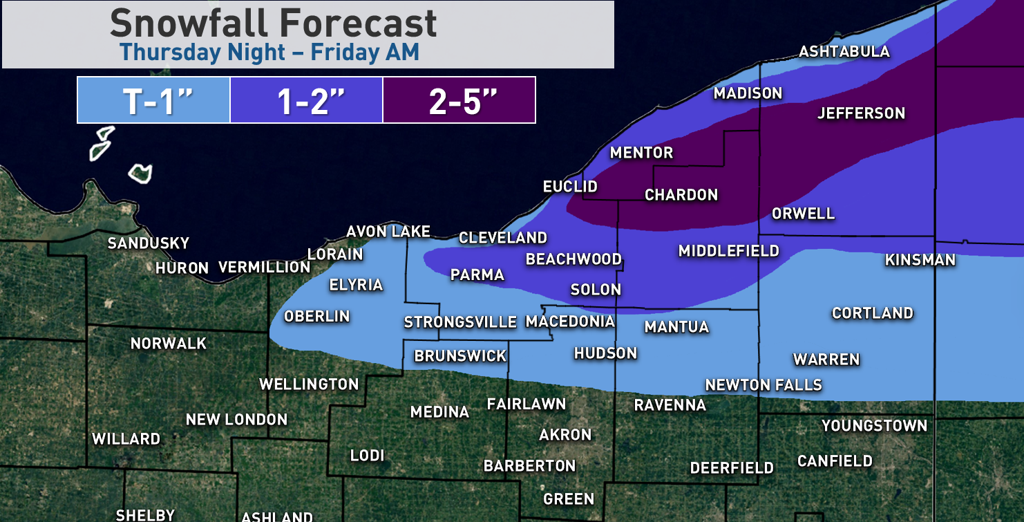
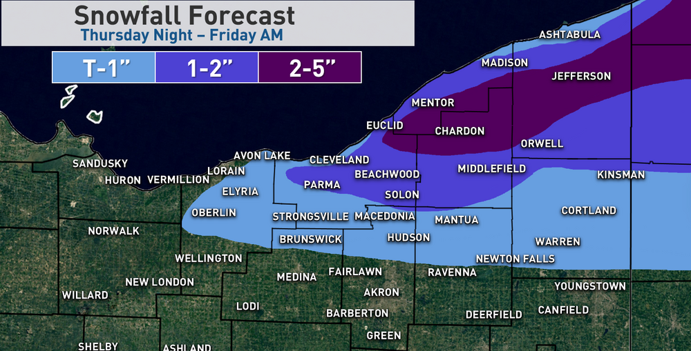
I was a little surprised to wake up and see the forecast from CLE and the watch. It seems like they've cut it back some today, and as Jim's post mentioned went with advisories which is probably the route I'd go too. If I have time after work today I may re-draw my map a bit, overall no big changes to my thinking. May bring the 2"+ line a little farther south in some areas (especially eastern Cuyahoga and southern Geauga). I could see how someone in either southern Lake / northern Geauga or in the eastern half of inland Erie County PA sees 6" of snow, but I think most of that would come with the W-E oriented bands that will set-up the first portion of the event before the winds shift more WNW. Occasionally those stronger convergent bands ahead of an approaching trough can really rip, but they also tend to hug the eastern lakeshore and go into Erie County so may be too far north for many of the posters here. As the winds go WNW pre-dawn Friday I could still see how the lingering banding gets "stuck" for a few hours along the western lakeshore and drops an OK amount on parts of Cuyahoga and southwestern Geauga, but since the ridging will begin nosing in by then I don't think it'll quite have the same intensity as bands earlier in the night may have. I suppose this is as good of a time as any to mention that I'll be moving back to the area in early December...to work at NWS CLE. I am excited to be able to move back to the area after a few winters, and of course am thrilled to be starting a career at the NWS. Hopefully the next several LES seasons keep us all on our toes!
-
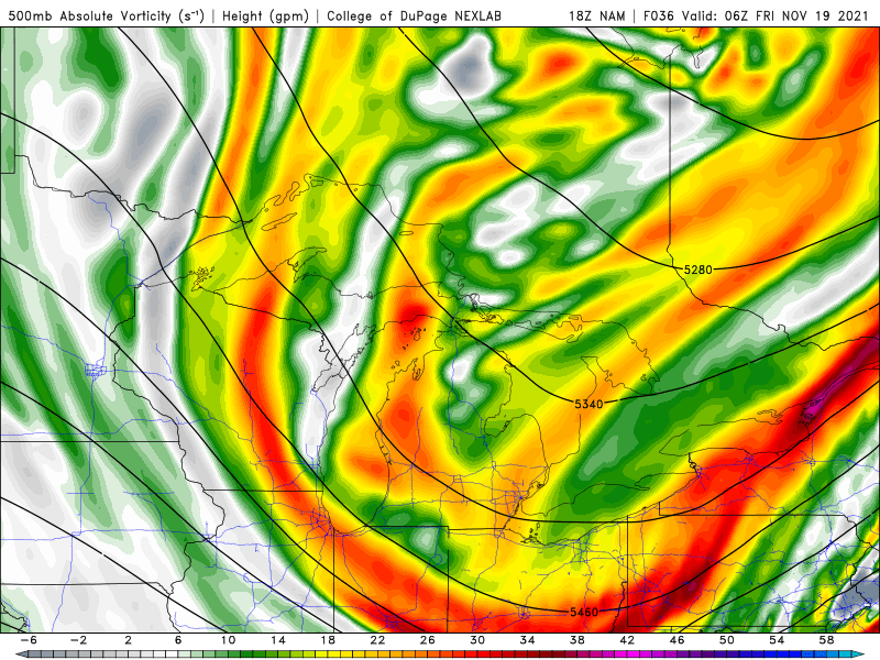
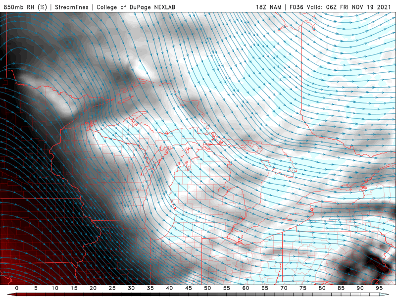
I'll go with this for now...expect a couple of W-E oriented bands to set-up Thursday evening in NE Ohio and NW PA, likely one from northeast Cuyahoga, Lake, northern Geauga into Ashtabula, and probably another one into the northeastern half of Erie County in PA. With lake-induced instability climbing to extreme by late evening, with 850mb to lake differentials of over 20C and 700mb to lake differentials of over 30C, and inversion heights and moisture depth to around 10k feet...which through the dendritic growth zone...thermodynamics will support moderate to heavy (and fairly wet) snow. A well-aligned flow, some pre-seeding from Lake Michigan, strong convergence near the eastern lakeshore and some moisture and lift ahead of a vort max will aid in getting a good lake response. Rates in any W-E oriented bands may reach 1" an hour of fairly wet snow beginning Thursday evening. Overnight, around 2 AM, winds go more WNW and bands will shift inland accordingly. Max amounts for the event overall will likely be in extreme northeast Cuyahoga, southern Lake and northern Geauga as they'll get a few hours of banding in the evening on the west wind when conditions will be rather ideal...question is how much stuff can add up overnight as it shifts inland. It's a little tricky...normally you take the under on the southern extent of snow with this type of set-up when the band will initially be tied to the eastern lakeshore and into the northern primary Snowbelt...and for now I was more conservative than some models on the southern edge. But the winds at 850mb and over the lake come around to 290-300 degrees overnight which can push snow pretty far inland. Inversion heights, instability and moisture depth gradually decline into Friday morning but snow may be moderate under any bands until about 12z Friday, so there is juice for a few hours after winds go WNW. For now took a blend of all these ideas and went 1-2" for the northern and eastern half of Cuyahoga, the rest of Geauga and Ashtabula, and clipped extreme northern Summit, Portage and Trumbull with it. Ratios won't be that high, plus winds gradually shift overnight after the shortwave goes through so it may be hard to add up a ton in these areas, though we'll see if the band can briefly get stuck somewhere over Cuyahoga County and produce a small 2 or 3" lollipop there. Heaviest amounts overall in the higher terrain where the W-E bands in the first half of the night impact, where several inches are possible. Little shortwave moves through overnight, and that will add a little bit of synoptic moisture and lift between about 10 PM and 3 or 4 AM: Connection to Lake Michigan: Strong convergence along the eastern lakeshore: BUFKIT shows extreme instability, fairly weak shear, moisture depth and inversion heights near 10k feet, and sufficient moisture and instability into the DGZ to make OK flakes aloft: Winds shift a little more WNW the rest of the night on this run.
-
I feel good about advisory criteria snow for parts of NE OH and NW PA Thursday night into early Friday right now. It's a briefly good lake effect set-up and with 850mb temps dipping to -8 to -10C it should pretty safely be cold enough to accumulate well away from the immediate lake (which hasn't been the case with any LES setup yet this fall...though the synoptic snow did well last weekend). Winds are mainly W for the bulk of the event but will gradually swing more WNW by early Friday before the ridging really clamps down on things, so in NE OH I think the heaviest probably falls near 322 or perhaps slightly north, but as the winds go WNW it should get into the rest of Geauga and even a decent chunk of Cuyahoga early Friday. I think it's generally a 2-5" snow inland from the lake for parts of Lake, northern Geauga, Ashtabula and Erie Co's but if the band stalls for a few hours over one spot like some models suggest there could locally be a bit more. For most of central and eastern Cuyahoga and spots like southern Geauga probably more like a 1-3" deal in the hills (and less closer to the immediate shoreline).
-
Some Thoughts on the Winter 2021-22 Outlook
OHweather replied to OHweather's topic in Weather Forecasting and Discussion
1981-82 is an interesting analog. The December pattern featured a huge -NAO but with a -PNA. I'm sure plenty of winter weather fans across the country would take it. -
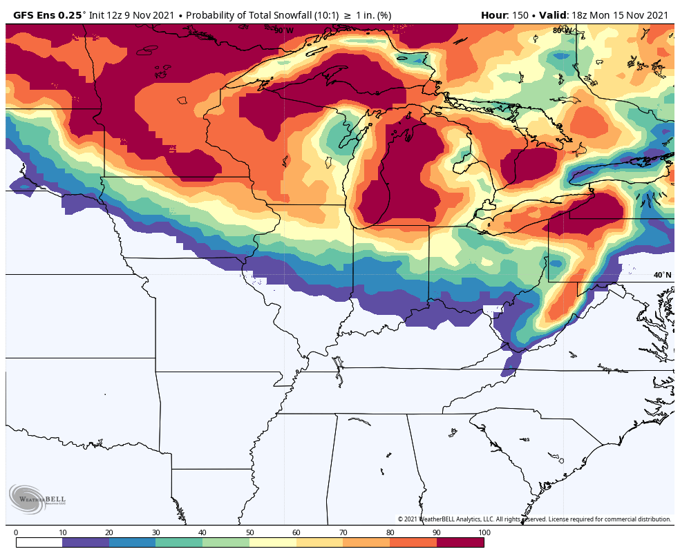
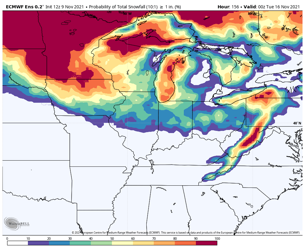
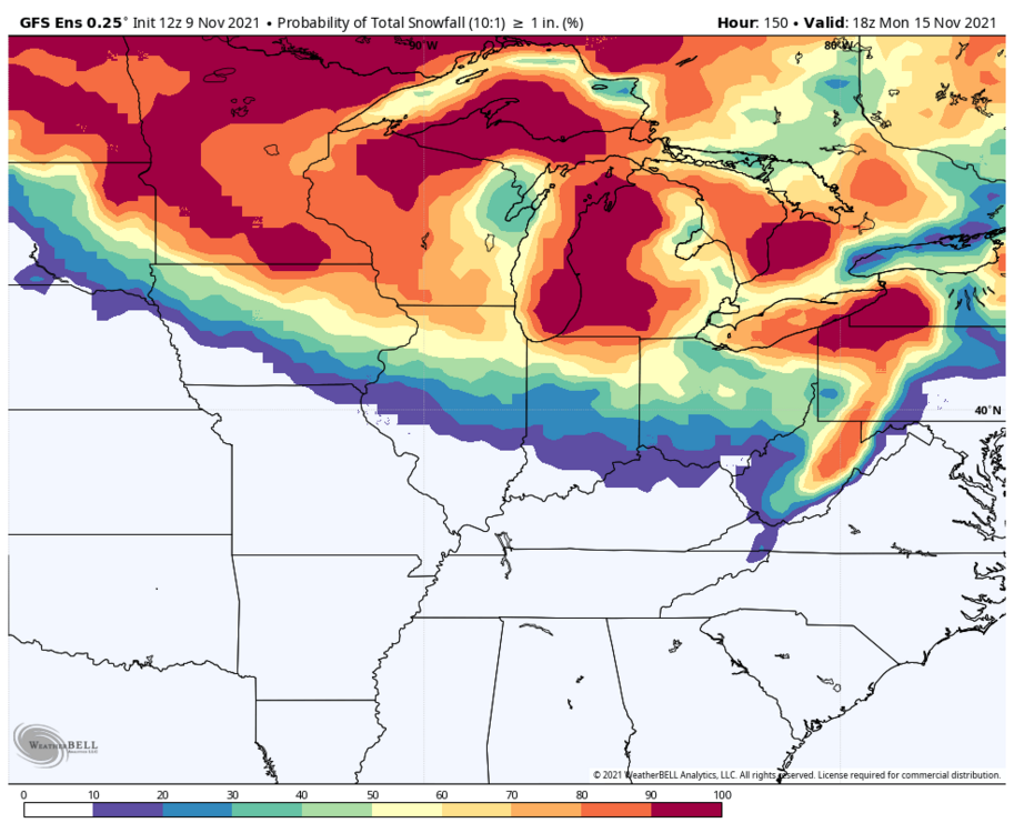
Could it be? November 13-15 Potential Snow
OHweather replied to Hoosier's topic in Lakes/Ohio Valley
This looks decent... Strong omega in and about the DGZ, and some steep lapse rates in the mid-levels too, it's close to being convectively unstable too. It'd rip for a little bit.
-
Some Thoughts on the Winter 2021-22 Outlook
OHweather replied to OHweather's topic in Weather Forecasting and Discussion
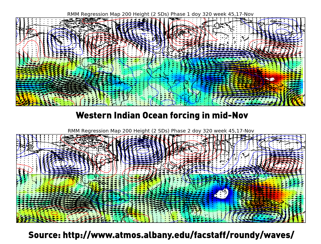
It doesn't help that the forcing may pull back west into the Indian Ocean again after mid-November. Just not enough blocking yet for sustained cold. -
Could it be? November 13-15 Potential Snow
OHweather replied to Hoosier's topic in Lakes/Ohio Valley
This isn't the worst look for a swath of light snow accumulation. As modeled, that shortwave would be potent enough for a swath of brief moderate snow that can overcome any ground / boundary layer "marginality" and accumulate. I guess one thing to watch for is that the shortwave doesn't trend flatter, as it's a fairly low-amplitude as RC's AFD said. QPF would decrease as would precip organization and intensity, which would make it harder to see accumulating snow.

-
Some Thoughts on the Winter 2021-22 Outlook
OHweather replied to OHweather's topic in Weather Forecasting and Discussion
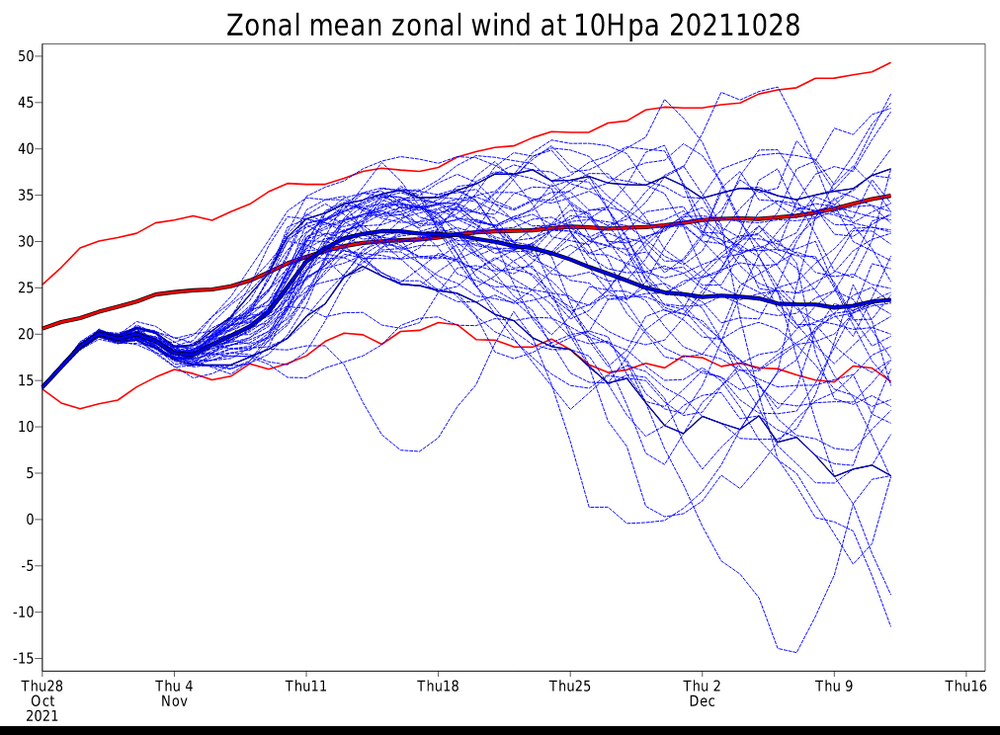
Yeah at the moment I also don't foresee any sort of early sudden strat warming event...granted, these things aren't very predictable more than a couple - few weeks out (and even then it's often just "hints" until it's closer in). But as long as we don't have a strong / coupled strat and tropospheric PV (like January - March of 2020) it's not necessarily bad on its own. I think the PV will see enough minor disruptions in the coming several weeks to prevent that outcome. -
Some Thoughts on the Winter 2021-22 Outlook
OHweather replied to OHweather's topic in Weather Forecasting and Discussion
Forcing that far west in the middle of winter does turn into a short term warm signal as wavelengths get longer. If there's a lot of blocking it may not get super warm, but it would increase risks for warmth (possibly prolonged) mid-winter with all else being equal...that's why Ninas often start cold then get milder. Moving back to the Cleveland area. Though my few years here have me interested enough in East Coast snow that I'm sure I'll still pay some attention, especially in the mid-long range. -
Some Thoughts on the Winter 2021-22 Outlook
OHweather replied to OHweather's topic in Weather Forecasting and Discussion
I am going to try to get to it the next two weekends...my thoughts on the overall evolution haven't changed drastically yet, though I do want to refine thoughts and put out monthly maps for December-March. I'm moving and starting a new job in early December, which I was not expecting in early October when I promised final thoughts in November lol...but I still want to try to get to it in some fashion the next couple of weeks whenever I can. -
Winter 2021-2022 Outlook
OHweather replied to 40/70 Benchmark's topic in Weather Forecasting and Discussion
Ray, that was a great read and forecast, thank you for taking the time to put all of that together! As you know I agree with most of your general ideas. I especially enjoyed how you looked a little closer at certain La Ninas and explored why they were milder or colder than other La Ninas...and based on how this one is leaning, it seemed to me that your research pointed to decent blocking potential? I also found it interesting that you found that eastern Pacific La Ninas, along with La Ninas in an easterly QBO (removing 11-12), tend to be colder later in the season than December, which kind of bucks the "typical" La Nina expectations. I am curious to see how this year plays out. We had a number of similarities in our analogs, and mine also bring back blocking for the end of the winter after relaxing for several weeks January into February. I do think December may be quite cold this year so it could be very hard to pull off a colder Feb than Dec this year, but that could at least indicate that we get a nice shot of cold and snow potential early, and that there's at least an argument for another shot late. I feel like a strat warming event, if one occurs, is a potential wrench. Like you, I'm skeptical of an early SSW (though there should be enough occasional disruptions to keep the PV from getting prohibitively strong). Typically when an SSW occurs it's mild over the eastern CONUS when it happens, and gets cold a couple to a few weeks later, so an early SSW in December or early January could really change-up the December-January portion of the forecast (as we kind of saw last winter, with a mild period late Dec through mid-Jan as the SSW occurred, then a colder late Jan and Feb). However, I'm skeptical of an early SSW this year. But, if one occurs later in the season (such as 17-18) it could line up better with the expectation of a milder mid-winter period, then another crack at a colder / blockier pattern late. So, it will be interesting to see if we get a SSW that influences the pattern at some point. It's also possible the stratosphere is relatively more boring this year than in recent winters too. It seems like recent winters (since 17-18) have either had a true SSW event or have had a very strong PV, with nothing in between. -
Some Thoughts on the Winter 2021-22 Outlook
OHweather replied to OHweather's topic in Weather Forecasting and Discussion
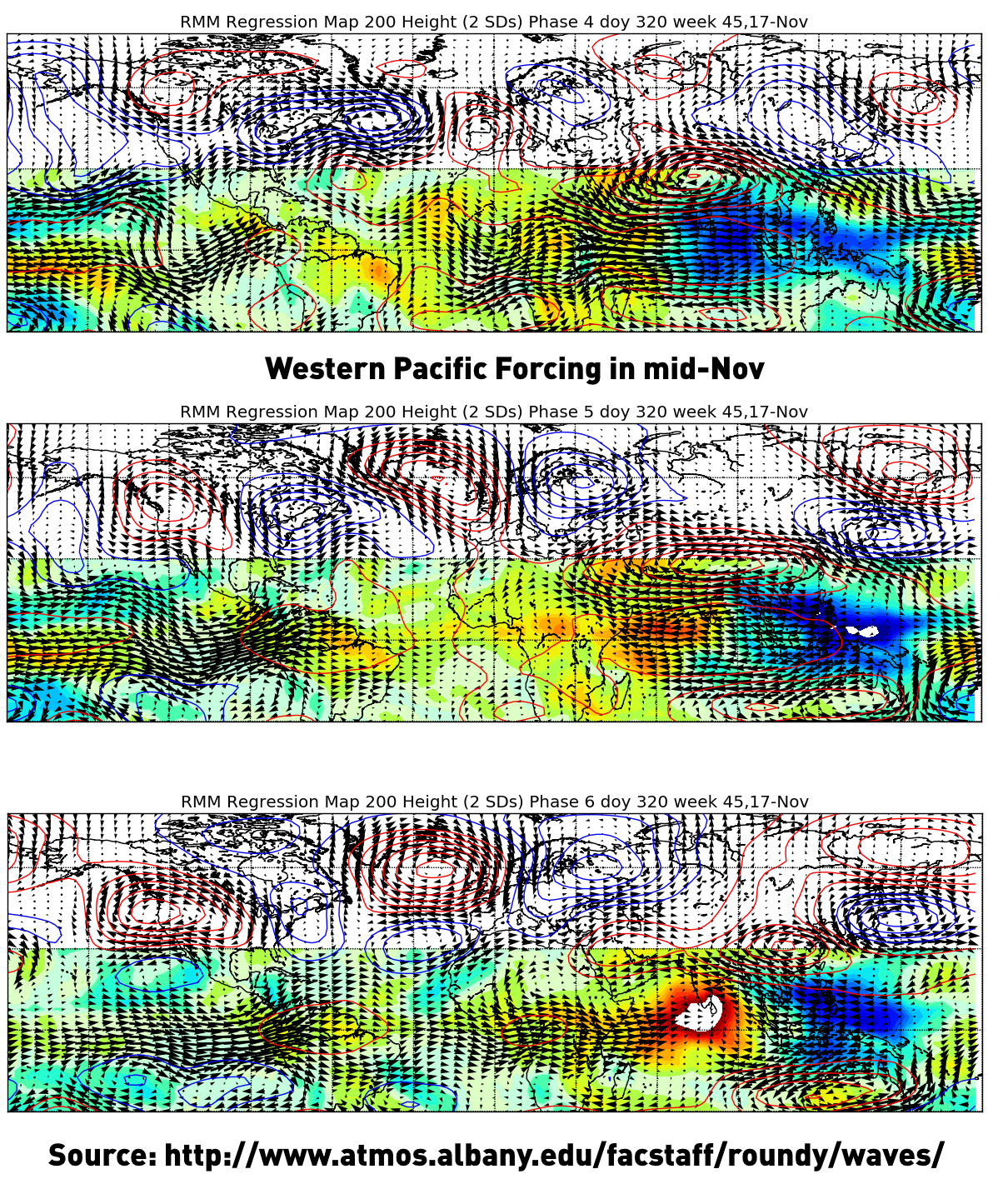
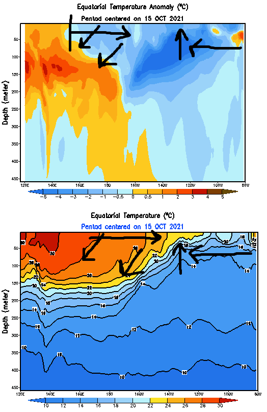
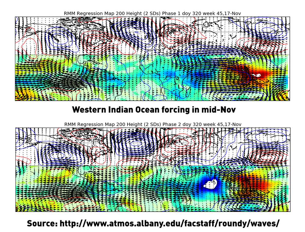
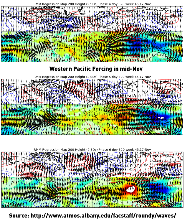
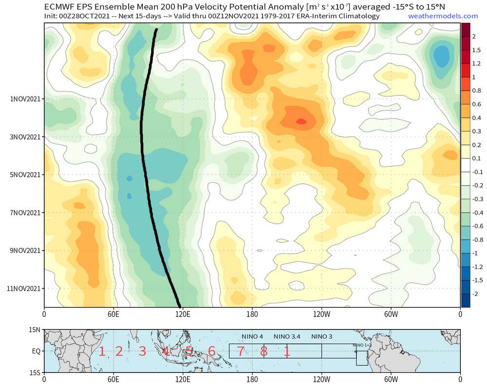
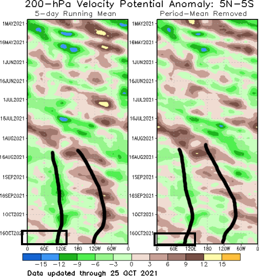
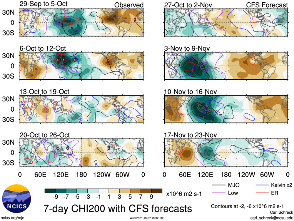
PRETTY SURE this fall is NOT going the way that the fall of 2011 did... Due to ENSO and QBO similarities, it was necessary to consider it as an analog heading into the fall. However, that year featured persistent western Indian Ocean forcing, near 60E. That teleconnects to a +EPO in November: http://www.atmos.albany.edu/facstaff/roundy/waves/ (yes I know you can't click the link on the image) This year, the forcing is definitely focused closer to the Maritimes, near 110-120E: That teleconnects to a -EPO in November: And the models are obliging, for now. While I'm not 100% sure what this winter is yet, I am pretty sure that it's NOT 2011-12 or anything particularly close to it.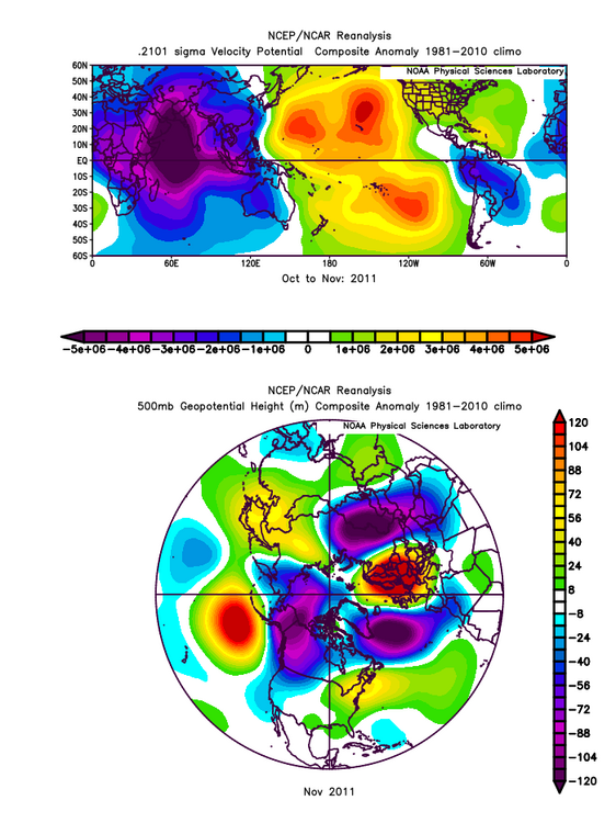
-
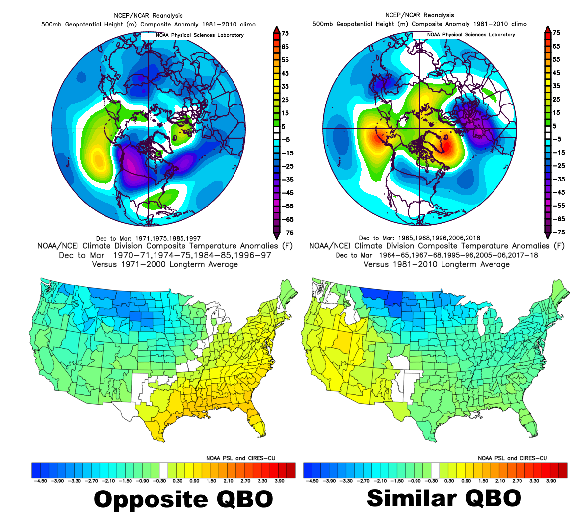
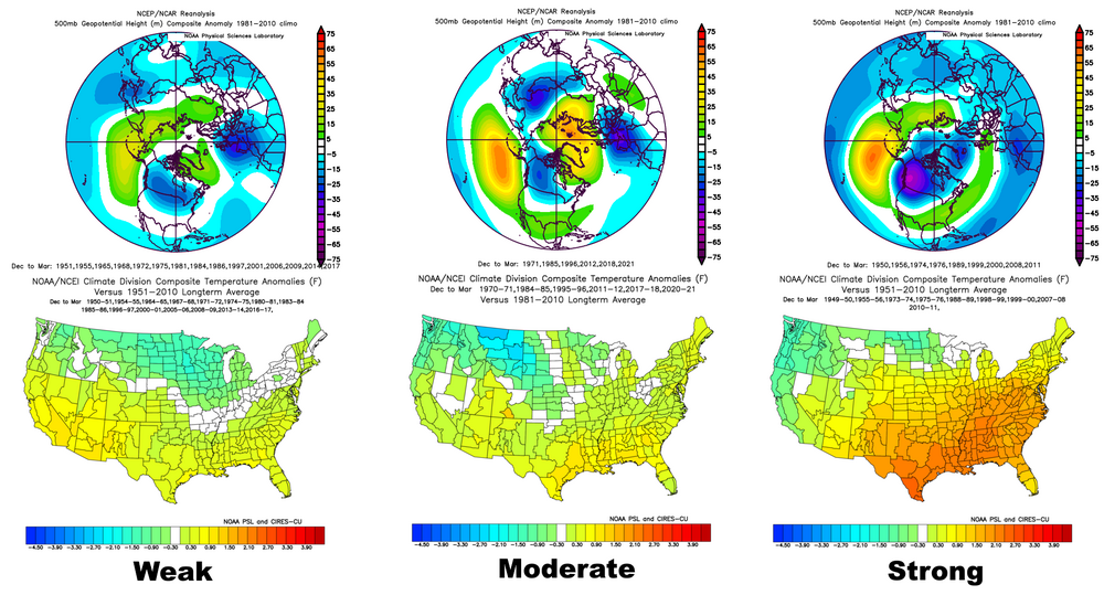
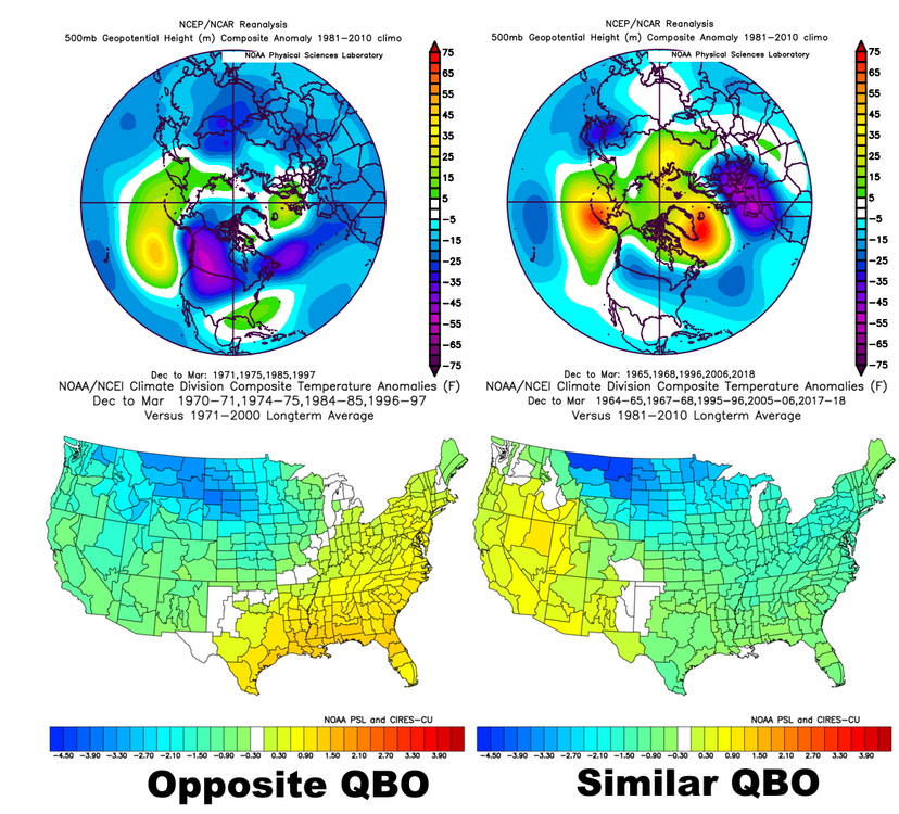
There is some support for Chuck's teleconnection outcome... Moderate La Ninas which this one is have a nice -NAO signal, but with a +EPO. The AO is close to neutral: This is a hybrid or basin wide La Nina...also supports a -NAO, but +EPO and AO: With that outcome, it'd generally be tougher to snow farther south, but would be an active northern stream and if ridging briefly amped into Alaska it'd get cold farther south and could snow. The -NAO keeps the Great Lakes and New England from torching. But, the descending easterly QBO may give some more hope (hybrid and east-based weak to moderate La Ninas with westerlies descending or easterlies...we have easterlies this winter): I like a -NAO this winter. I think the AO and EPO go positive at times, but also think we get a nice crack at a -AO and -EPO through December, so we could have quite a cold start before those trend more positive January and maybe February...then the SE ridge flexes more, but the NAO may hold off a torch in the Great Lakes and New England. That's kind of what I envision...Chuck's -NAO/+AO/+EPO could pan out for the season overall, but with a cold start and then still somewhat variable in the Great Lakes and New England, but milder farther south.

-
Are you thinking -NAO, -PNA, +EPO this winter?
-
I knew it couldn't be a good sign when I checked for the PNS and saw a damage survey from the October 21st tornado outbreak. Bands never got organized last night...kind of funny that the best accums in NE Ohio occurred during the day yesterday in Lake County when it was in the mid 40s outside of the bands...I saw a few pictures on Twitter of some light accumulations (maybe up to a few tenths) yesterday in Lake County.
-
Interesting little lake effect set-up tonight - Tuesday night for parts of NE OH / NW PA. As dta said, decent shot at flakes at the least. Beyond some graupel in heavier showers, it should be mainly rain through tonight with a W to WSW wind keeping activity confined to extreme NE OH into PA / SW NY. It becomes colder aloft on Tuesday with a W flow persisting, with a shortwave moving through late morning / afternoon from west to east, which may focus a couple of decent W-E oriented bands for a few hours and probably causes a few diurnal (non lake effect) showers to pop inland, which could fall as some sort of mixed precip. It should be too warm during the day for more than a slushy coating of snow or graupel in parts of NE OH / NW PA into SW NY, though will likely be cold enough for a decent amount of mixing in any heavier squalls or bands. Tuesday night is a little more interesting, with another shortwave moving through late-evening into the overnight from west to east across the lake. One or two more intense W-E oriented bands (along with orographic enhanced showers) should flare-up in the evening, and then at some point overnight shift inland and break up as the shortwave goes by and shifts the flow more NW'rly, and as drier air starts working in later in the night. With 850mb temperatures of -5 to -7C and 925mb temperatures of 0 to -2C through the night, it's close to cold enough to consider decent accumulations in the higher terrain where banding occurs. It's marginal overall, 1-2C warmer aloft than the October of 2013 event that dropped up to 8" in the eastern suburbs, but where banding and terrain combine to maximize potential there could be some localized accumulations of 1-3" in parts of NE OH / NW PA, along with the higher terrain of SW NY Tuesday night. With a well-aligned westerly or WNW flow Tuesday evening, lift from the shortwave, upstream moisture from Lake Michigan and extreme lake-induced instability, there could temporarily be the organization and intensity needed to drop some actual accumulations, especially in the higher terrain. We'll see what happens...flakes are a good bet, but there could be some localized but quick accumulations under any banding Tuesday evening into the night...particularly in the higher terrain from extreme eastern Cuyahoga into northern Geauga, inland Erie County PA and inland SW NY.
-
Some Thoughts on the Winter 2021-22 Outlook
OHweather replied to OHweather's topic in Weather Forecasting and Discussion
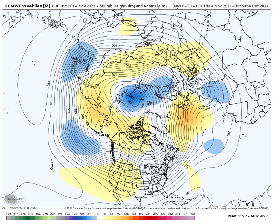
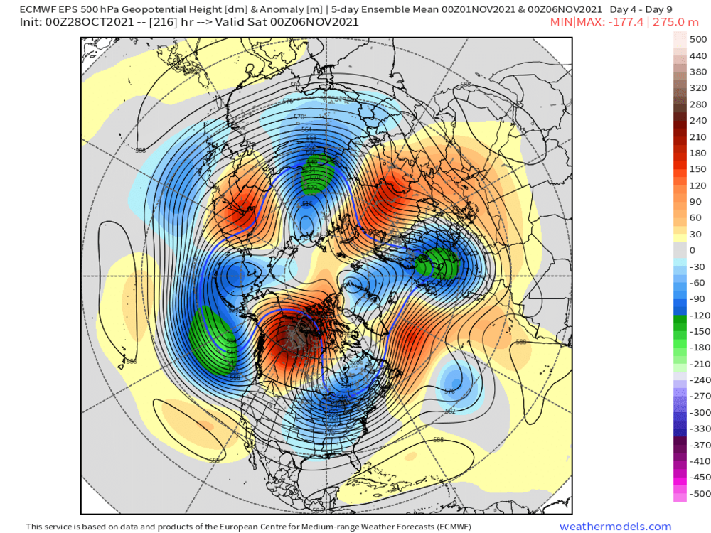
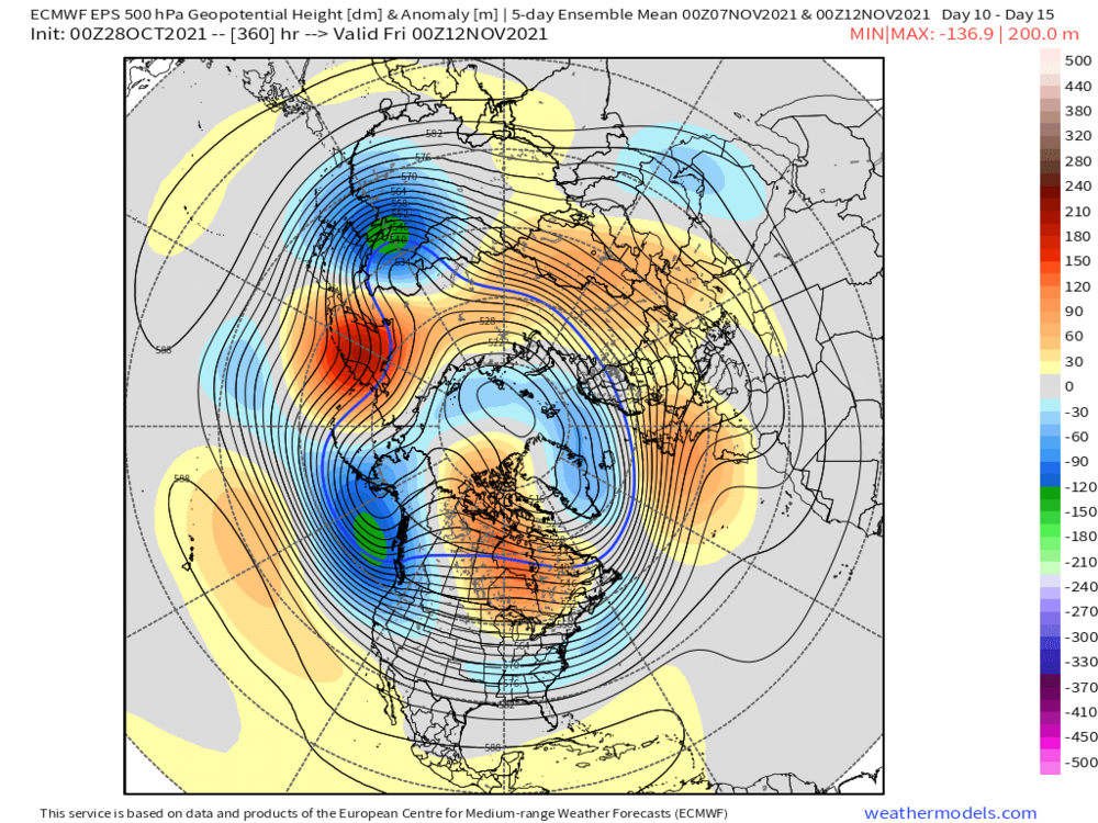
The EPS weeklies from yesterday...mid-November into the first half of December there's some cross-polar flow along with a -NAO. The Pacific side is less cooperative, but verbatim it'd be active and chilly enough to be interesting for a lot of the northern US and maybe into the central US at times. If the Pacific pattern ever amped, it could get pretty cold. Interesting run at the least. A lot of members have a weakened stratospheric PV as well.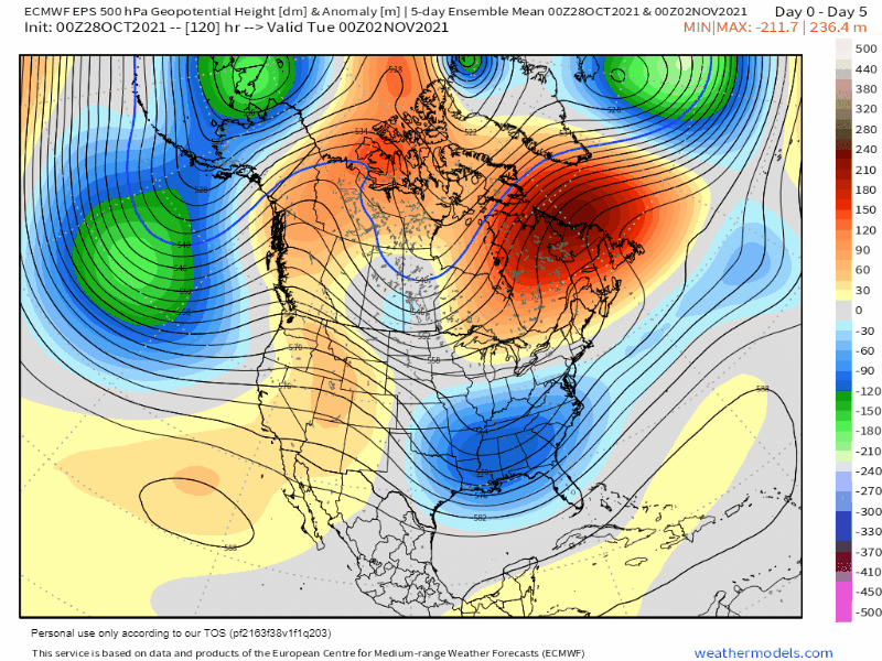
-
I think it depends on where you are in the west. I think the Pacific NW, northern CA and the northern Rockies have a decent shot at a wet winter. Far from sold on that farther south though.
-
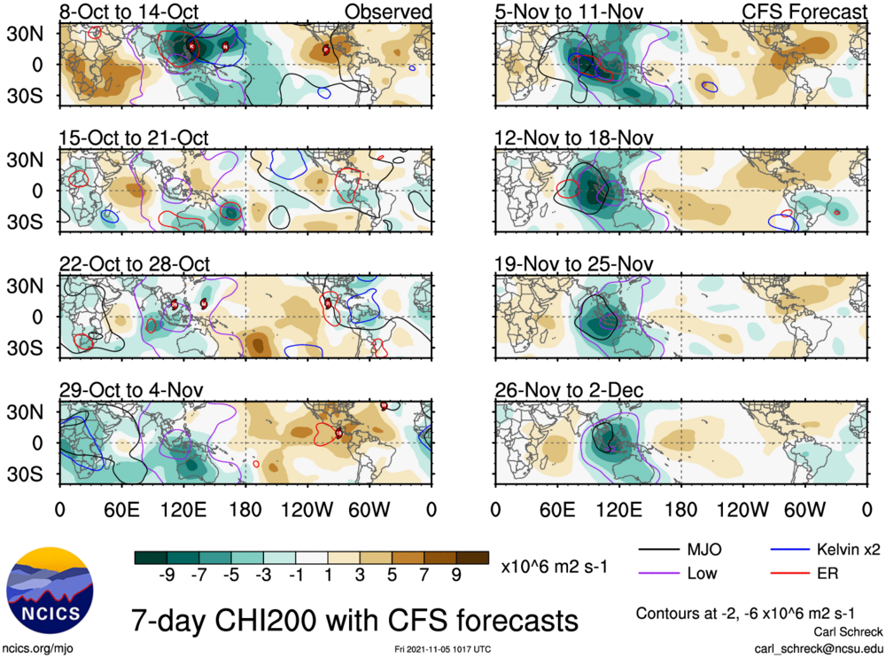
The Pacific jet is pulling back in the short term, briefly allowing for nice amplification over western Canada and a nice cold shot in early November... It's a decent shot and some areas may see flakes, but I don't think we're done with Pacific influence yet, as there's been agreement the Pacific jet rams into the West Coast again into mid-November. We won't completely torch as there will be more chilly air running around, and it will be an active pattern as that energy undercuts the ridge over Canada, but it will probably lean mild again into mid-November: Looking farther ahead, the low frequency forcing near 120E has drifted west into the Indian Ocean recently, and is beginning to constructively interfere with the MJO: Will the MJO be able to pull the forcing back east towards 120E (and perhaps a bit farther into the West Pac) in mid-late November? The EPS and CFS velocity potential forecasts are attached: In the fall and beginning of winter, tropical forcing moving into the western Pacific tends to suggest potential for blocking to develop in the short-medium term: I think November ends up being up and down and not that cold overall over the central and eastern CONUS...however, there will be a nice cold shot to start the month and an active looking pattern, so I'm not saying something can't come together right and snow somewhere. But, I think we have trouble sustaining cold through the first 20 or so days of the month. Tropical forcing working into the western Pacific mid-late November could signal an opportunity for a more robust pattern change that can bring more significant and sustained cold.
-
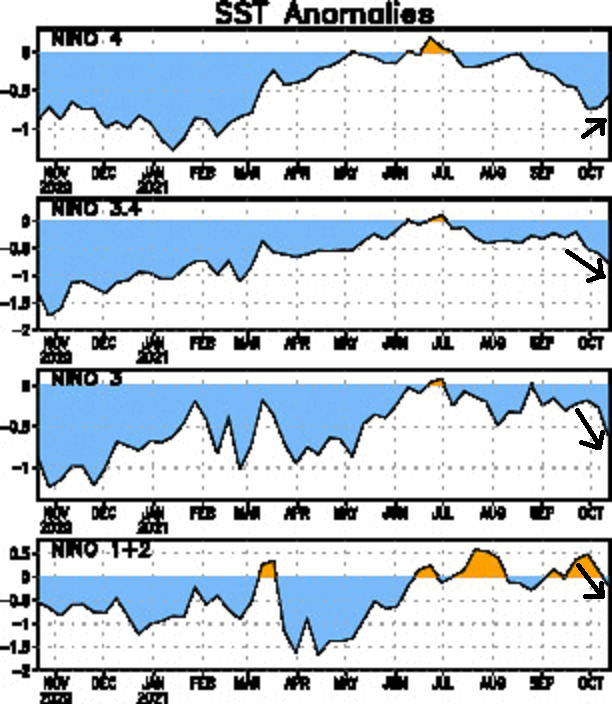
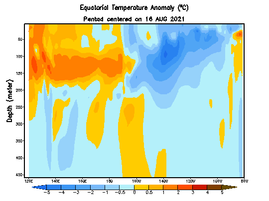
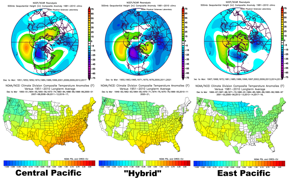
I like that the strongest cooling this month has been in regions 1+2 and 3, as 4 warms slightly. Steady cooling in 3.4. A trend towards either a basin wide or east-based La Nina, away from Modoki. The sub-surface loop implies this trend continues in the near future. Staying away from that central Pacific or Modoki La Nina look is a good thing for -NAO prospects this winter...