

OHweather
-
Posts
5,046 -
Joined
-
Last visited
Content Type
Profiles
Blogs
Forums
American Weather
Media Demo
Store
Gallery
Everything posted by OHweather
-
Yeah, there definitely was some positive feedback over Lake Erie that night with the convection helping to develop a mesolow, which in turn then kept the convection relatively stationary and intense.
-
There have been a few of these massive downpours over Lake Erie during the summer months over the last several summers. It happens when the lake water is in the upper 70s/lower 80s and we get slow moving convection over the lake (usually at night). Put-In-Bay got 8-10” of rain and flooded one night in August 2023, and there have been a couple other times where I remember radar estimates of 10”+ over the open lake. This event was very high end and affected an island directly. There was significant flooding from 4-7” of rain (after 1-3” the day before) along the western Lake Erie shoreline on Monday from continued lake enhanced thunderstorms.
-
How large was it in your area? Definitely think there was some 2”+ diameter hail in SW Geauga around Bainbridge/Auburn, but wasn’t sure if the largest skirted south of you and DTA. Some pretty significant damage with it as you said and it was across a long swath from the southeastern suburbs and through northern Trumbull across OH and it continued into PA. We had roughly quarter sized at the office in Brooklyn Heights, the core of it missed us by a couple of miles which I was ok with!
-
We heard (and felt) the sonic boom from the meteor at the office in Brooklyn Heights, and then dealt with a barrage of phone calls and media requests that rivals a major severe weather event. What a day. Also saw some gnarly snow squalls today (and drove on some icy roads last night and this morning) as March does its thing. I believe that 85mph gust at Burke on Friday was the strongest gust measured at the site.
-
It’s always fun to guess if the low CLE measurements are real, or a product of “measurement difficulties” at an open airfield. In this case the snow was mainly upslope driven so they definitely got less, but it’s possible the measurement was still a little low there since it was pretty windy. I can say in Brooklyn Heights there was dramatically less snow than even 2-3 miles farther inland most of the day, it was pretty remarkable.
-
I had 3” during the day yesterday and a little over an inch more overnight. My total since Saturday night came out to 8.4”. In terms of counties needing warnings, it was really close in a few. The upslope definitely was more impressive than expected. The tricky aspect is the storm totals are impressive, but occurred between Saturday night and early Tuesday morning which is a very long duration. The heaviest snow was during the day yesterday and it was struggling to consistently cover main roads due to the higher sun angle for several hours. Still, some areas got over 8” and a <24 hour span which is getting to the point where it’s hard to look the other way. I’ll be looking closely at Medina and Geauga in particular…a few spots in Cuyahoga, Summit, and Erie Co PA were close to that as well, but Medina and Geauga seem most impressive overall.
-
The upslope has been performing quite well all day (arguably over performing). It’ll be confined to a narrow strip along the higher terrain from Medina to Geauga, but it seems like spots in there will come in with 6-9” type amounts. I got close to 3” overnight, pushing my storm total to 4” as of 7am. It’s been snowing pretty good at home all day, so I’m expecting to come home to over half a foot on the ground. Not a bad event, not really an impressive setup but the upslope is really pulling it out for the favored areas.
-
Had a bit under an inch here as of 10:30 AM, since then it's been snowing lightly at times but largely not accumulating. It looks like the best push of snow will be late tonight/Monday morning in the Cleveland area and NE OH snowbelt...west of Cleveland may see a half decent uptick late this evening, along with late tonight into Monday. Overall not the most exciting, but winter is back and the higher terrain/upslope areas should see snow add up to several inches by Monday night.
-
The squalls didn’t disappoint, at least where I’m at. Slept through a good portion of it, but it was nearly a whiteout when I looked outside and it looks like I’ve gotten 2-3” of new snow since 6pm.
-
There was definitely more freezing drizzle and less snow than hoped this morning. Upstream honestly looks a little underwhelming, but there’s still a bit of time for stuff to pick up before the front gets here.
-
Recently tallied up my seasonal snowfall, and I'm sitting at 67" to date. Last season, I had 68" all winter. Friday's system looks like a nice refresher of the snowpack. It's more of a lobe of the polar vortex than a regular clipper...there will be synoptic snow in the warm advection ahead of the system Friday morning and afternoon, which looks like a quick 1-3". The more dynamic portion will be Friday evening/night, when an Arctic front pushes through. That should bring a nice burst of lake-enhanced snow (looking at satellite, the ice is still somewhat lose and has cracks, so there should be a limited flux from the lake), along with rapidly falling temperatures and strong wind gusts. It'll only last a few hours, but conditions will be quite harsh along and just behind the front Friday evening. Some limited lake effect lingers Friday night into early Saturday. The snow Friday evening through early Saturday probably adds a variable accumulation of 1-4" to most of the area downwind of Lake Erie, pushing event totals into a 3-6" type range.
-
After getting a little over 7" of synoptic snow through Sunday evening, got a little over 3" of LES overnight Sunday night through Monday. Event total of 10.4". Today, had about a two hour period of light to moderate snow late morning, followed by two pretty decent snow squalls in the early evening. Another 2.2". What a stretch of cold and snow! Could use a little warm up soon though for sure!
-
The strongest lift was focused above the preferred dendritic growth zone (DGZ) for most of the storm…so flakes were forming in a part of the atmosphere that was too cold for good crystal growth. It seemed like there were bands of higher ratios across parts of NW OH, and then down towards central OH ENE towards YNG, with lower ratios in between. It’s not uncommon to get bands of higher/lower ratios based on where better banding sets up, and is not easy to predict ahead of time unfortunately.
-
The fluffy lake enhanced snow last night into this morning has been a nice bonus…I was a little over 7” for the synoptic snow, but was at a running total of 9.6” this morning after the overnight lake enhanced stuff. A few spots may add 2-4” of fluff today. The lake enhanced snow will make most of the totals look nicer in the metro area.
-
1/24-1/25 Major Winter Storm - S. IL, IN, and OH
OHweather replied to A-L-E-K's topic in Lakes/Ohio Valley
Fluffy/efficient lake effect processes occurring beneath/within a broader synoptic snow are basically magic in terms of getting good snow, but it’s rarely organized into a firehose like what’s been going into Toronto. -
1/24-1/25 Major Winter Storm - S. IL, IN, and OH
OHweather replied to A-L-E-K's topic in Lakes/Ohio Valley
Glad the lake effect came through for the Chicago folks! -
Yeah I’ve been underwhelmed by this in the Cleveland area. I’m at 6” or so right now…one more better band to swing through the next few hours then it’s down to off and on lingering lighter stuff through Monday. The drive in this morning was pretty bad, the drive home was not any worse, so it just wasn’t snowing much during the day at times. The snow to liquid ratios at some of the airports through 1 PM was near or only a little over 10:1, so I think the big issue was we needed ratios to come through for bigger totals and we largely have struggled to make good flakes most of the storm. Overall it’s still a warning level snow in what’s been a cold and snowy stretch, but am a little bummed that despite last minute upticks in guidance until pretty much hour 0 we’re finding a way to come in on the disappointing side around here. Par the course for synoptic snows I guess. The Canton and Youngstown areas have or will clear a foot, so it was close.
-
1/24-1/25 Major Winter Storm - S. IL, IN, and OH
OHweather replied to A-L-E-K's topic in Lakes/Ohio Valley
Even though the lake effect affecting the southwestern shoreline of Lake Michigan tonight into Sunday is rather shallow, forecast soundings within it depict strong low-level instability with lift maximizing in the DGZ. Supportive of relatively intense and very fluffy/high ratio lake effect. If the band can sit over an area for several hours...which may be possible somewhere over NE IL or far SE WI within a few miles of the lake...there's definitely local overperformance potential into the 6" range.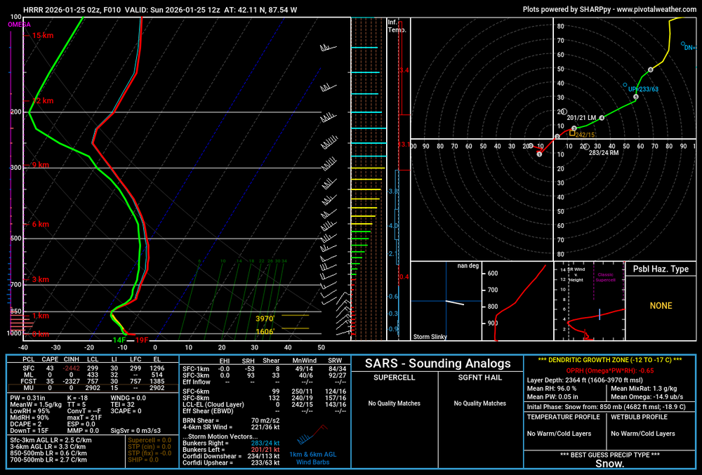
-
Let’s talk winter!! Ohio and surrounding states!! 24'-25'
OHweather replied to buckeye's topic in Lakes/Ohio Valley
Everything seems to be lining up for this to be a pretty epic storm for Ohio, with almost the entire state seeing 6"+ and a thick swath of 12-18" looking likely. All models really locking in today, the only question is how quickly mixing punches into SE OH. This will definitely be the biggest snow for the state (overall) since the February 5-6, 2010 storm and will not be far off from that one. -
Good trends today, slightly more amped and a bit more QPF across northern Ohio. I’d go 9-14” across all of Northeast OH (best shot for a foot plus appears to be Akron-Canton over towards Youngstown), tapering a bit (let’s say 7-11”) towards Sandusky and a bit less but still solid (6-10”) towards Toledo. There may still be a fairly sharp gradient between double digit amounts and amounts closer to 6” somewhere between the I-71 corridor and NW Ohio, though I think everyone a little further E/SE is in great shape for the biggest synoptic snow since at least early 2022.
-
1/24-1/25 Major Winter Storm - S. IL, IN, and OH
OHweather replied to A-L-E-K's topic in Lakes/Ohio Valley
Yeah that seems like a fair bare minimum. To their credit, they’ve realized that the FV3 core the GFS/RRFS currently run on won’t work, and the next version of the RRFS will be run on an MPAS core. Early indications are that will be much better. With that said, that they’ve decided to still move ahead with making the RRFS/REFS operational and turning off the NAM and several other models that go into the HREF while the RRFS still is running on the shitty model core that they’ve acknowledged they need to replace is certainly a choice. -
1/24-1/25 Major Winter Storm - S. IL, IN, and OH
OHweather replied to A-L-E-K's topic in Lakes/Ohio Valley
RRFS is cheeks Although NAM is also cheeks in its own ways Feels like a one step forward one step backward kind of tradeoff (although turning off most of the HREF members and going to the REFS is an additional step backwards IMO) -
A model's QPF does in theory take into account things like low-level RH and if precip will make it to the ground, but some models struggle more with it than others. We don't assume a static snow ratio...the NWS snow forecast largely comes from taking QPF (which is usually a blend of many models and ensemble members...outside of lake effect situations) and snow ratios (which do adjust based on the modeled temperature/moisture/lift profile, but certainly can be wrong at times) and multiplying them (more complicated calculations come into play with mixed precip or temps above freezing, which isn't the case here). I would say the CLE snow forecast has been a bit more conservative compared to some model output, but there are enough ensemble members that don't have as much QPF up here that that's likely why the forecast hasn't been as aggressive as say the last several Euro runs.
-
1/24-1/25 Major Winter Storm - S. IL, IN, and OH
OHweather replied to A-L-E-K's topic in Lakes/Ohio Valley
I'm still at cle yes Heh, if it does end up phasing quicker (which the 18z NAM tried to do) you may still be in play for some accumulation. But there isn't great news for a more significant trend in that direction IMO -
1/24-1/25 Major Winter Storm - S. IL, IN, and OH
OHweather replied to A-L-E-K's topic in Lakes/Ohio Valley
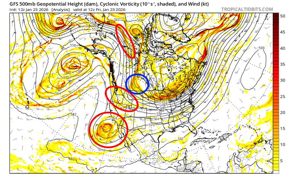
Just a few random thoughts...there've definitely been small but additive bumps SE over the last several runs of the non-GFS guidance. It's largely been caused by the PV over the Upper Midwest/Plains ahead of the storm refusing to lift out at all, along with subtle trends for perhaps a slower ejection of the storm into the Plains (lets the PV press in more ahead of it) and some lingering run-to-run disagreement over how well the storm phases over the southern Plains. Overall, I don't expect more than relatively small adjustments from here on in, but a quick look at how guidance has been trending and what still could change in my eyes... This is the European ensemble mean 500mb heights for the last several runs valid at 12z Sunday. There still are subtle run-to-run adjustments both with the exact placement of the PV and with how well-phased the trough ejecting into the Plains is...to me, the there haven't been substantial trends either way with the PV while the trough has trended perhaps a bit less phased overall. Heights are still rising plenty ahead of the storm and there may be room for a subtle trend back northwest if we see a better phase, but unless we see trends towards the PV lifting out quicker I don't think it makes a huge difference for those who are on the outside looking in for heavy snow. This is just the 500mb height and vorticity trends from the operational Euro...there are not clear trends towards a more or less phased solution overall, though there may be a slight trend for the trough to eject into the Plains slower, which in theory could give the PV a little more of a chance to press in ahead of it. The red circles are the main pieces of energy phasing together with this storm...the Baja low and shortwave diving into Canada have not been fully sampled yet, but will become increasingly sampled in the next sets of 0z/12z runs. There may be some opportunity for trends regarding how well the storm phases over those next cycles, though my guess is there won't be a significant trend either way. The shortwave circled in blue isn't really phasing into this, but will help dictate how much the PV presses into the upper Midwest/Plains Lakes north of the storm. My guess is we won't see a notable trend with the PV from here on out, though I've been surprised before. Overall, I think it's the PV over the Plains that is skunking those who needed more of a NW trend than we got and it doesn't seem like that's changing as the storm becomes more imminent. There is still room for subtle trends based on a quicker/slower phase, though any northwest trends won't be huge. It wouldn't shock me if there's another bump SE before we're done, though I personally don't want that if we can avoid it....thumb.gif.6307205752ec3d05a11a3662f5583c21.gif)
.thumb.gif.54ca0783746cb9a4b9ac9b560a3da26e.gif)
- 935 replies
-
- 14
-

-

-

-

.gif.e44f1c254ef807276a9242e4f2f799f0.gif)
.gif.4e00a1d802c3cce6aff4d98f7ffd86f7.gif)
