


OHweather
-
Posts
5,046 -
Joined
-
Last visited
Content Type
Profiles
Blogs
Forums
American Weather
Media Demo
Store
Gallery
Everything posted by OHweather
-
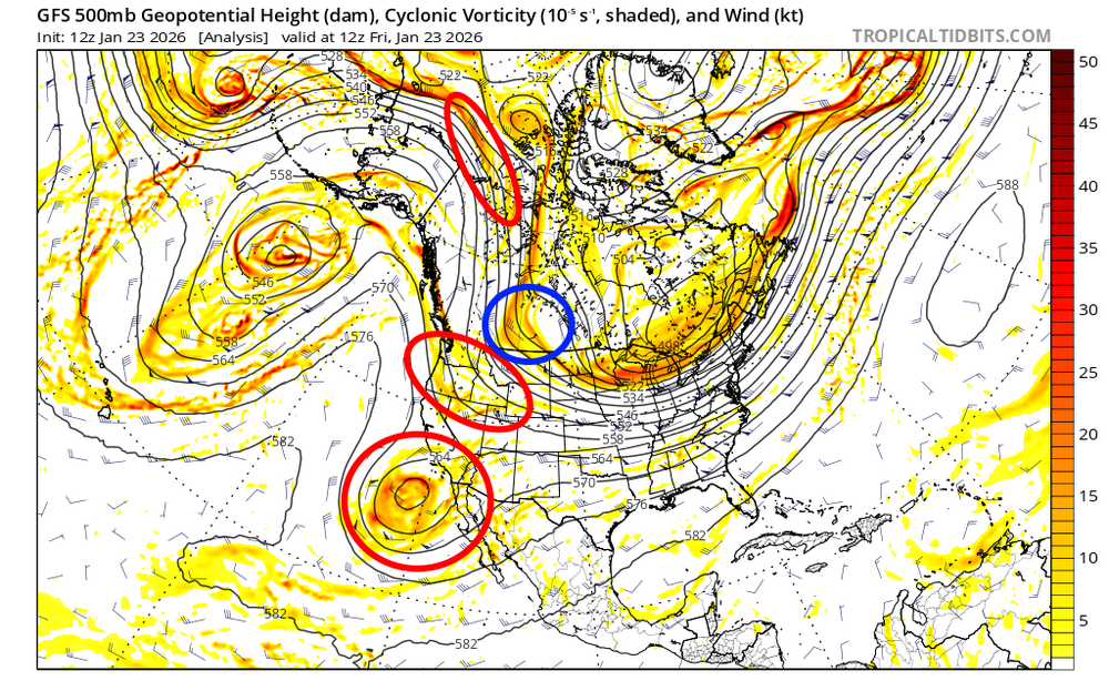
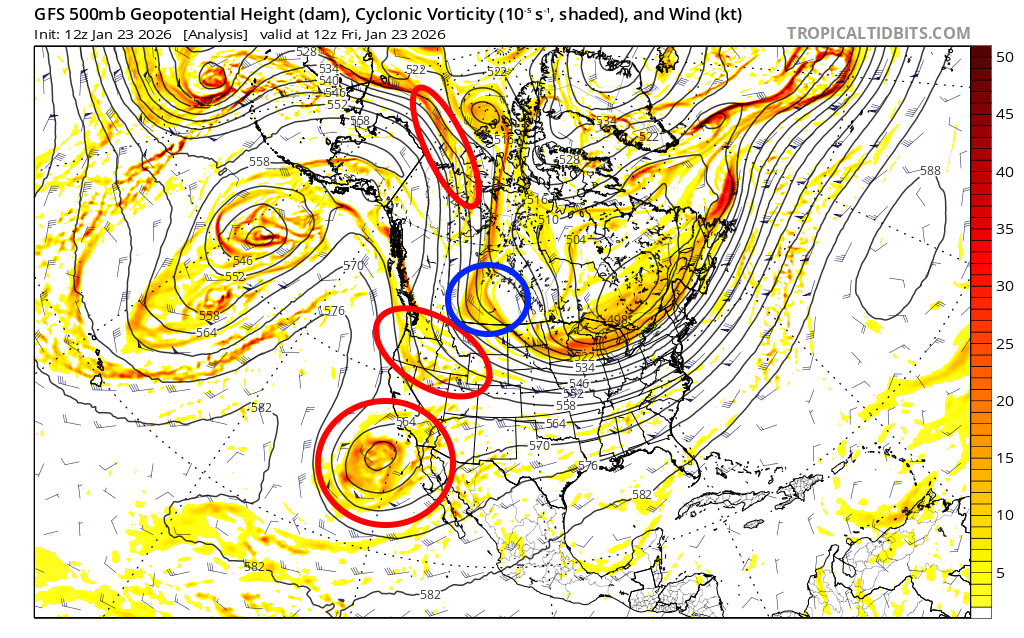
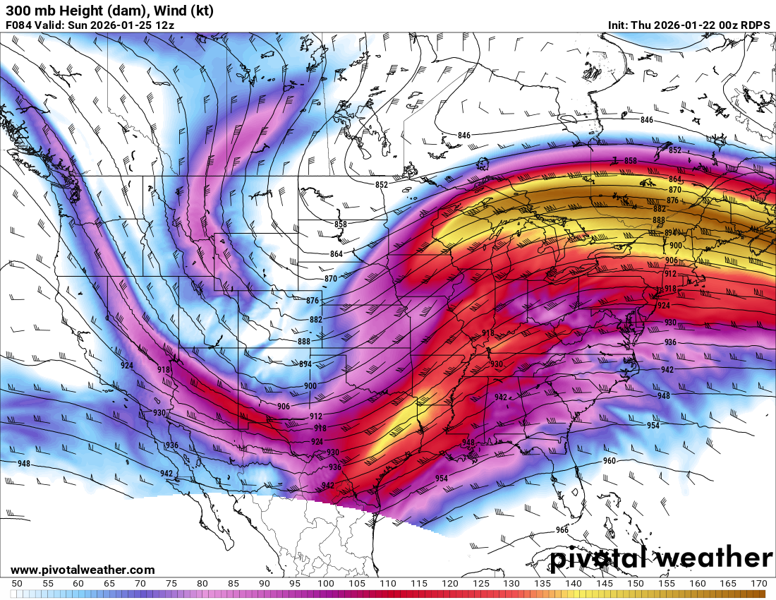
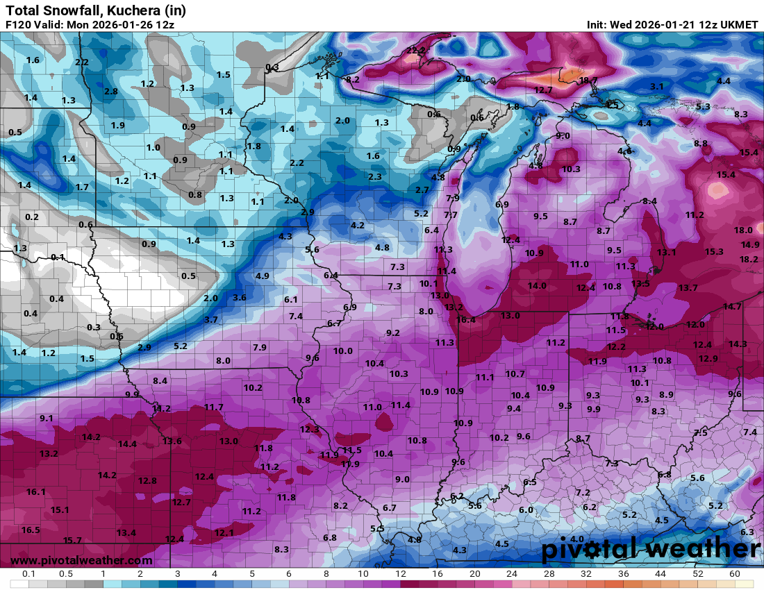
I think NE OH is in a good spot for this one...the heaviest QPF axis will remain a bit to our south, but soundings suggest ratios should be around 15:1 for most of the day Sunday (and likely climbing higher in any lingering lake enhanced snow by early Monday). There have been slight bumps SE in my eyes in both the 0z and 12z runs today, but we're still solidly inside the swath of heavier snow. Overall, I don't expect much more than small fluctuations/trends from here on in with this storm but I'll try to look at what could change. There are some sensitivities to both how well the storm phases to our southwest and how much the PV over the Upper Midwest/Great Lakes is trying to press in. A better phase would argue for a further northwest track, but northwest trends have been stunted for the last several runs now due to the PV to the north not lifting out much as the storm deepens and tracks NE Saturday night into Sunday. This is the European ensemble mean 500mb heights for the last several runs valid at 12z Sunday. There still are subtle run-to-run adjustments both with the exact placement of the PV and with how well-phased the trough ejecting into the Plains is...to me, the there haven't been substantial trends either way with the PV while the trough has trended perhaps a bit less phased overall. That has resulted in what I think has been a small SE bump in these recent runs. Heights are still rising plenty ahead of the storm and there may be room for a subtle trend back northwest if we see a better phase, but unless we see trends towards the PV lifting out quicker I don't think it makes a huge difference. This is just the 500mb height and vorticity trends from the operational Euro...there are not clear trends towards a more or less phased solution overall, though there may be a slight trend for the trough to eject into the Plains slower, which in theory could give the PV a little more of a chance to press in ahead of it. The red circles are the main pieces of energy phasing together with this storm...the Baja low and shortwave diving into Canada have not been fully sampled yet, but will becoming increasingly sampled in the next sets of 0z/12z runs. There may be some opportunity for trends regarding how well the storm phases over those next cycles, though my guess is there won't be a significant trend either way. The shortwave circled in blue isn't really phasing into this, but will help dictate how much the PV presses into the upper Midwest/Great Lakes north of the storm. My guess is we won't see a notable trend with the PV from here on out, though I've been surprised before. Overall, guidance has bumped SE a bit in recent runs but the overall change hasn't been much for NE OH, as we are pretty solidly inside the swath of heavier snow. There will be some snow from late Saturday night through Monday morning in NE OH, a long duration, with the heaviest occurring late Sunday morning through early Sunday evening as it looks now. Despite the icy lake, there will probably be some form of enhancement amid lingering light synoptic snow through at least Monday morning as the storm pulls away. My guess is rates will generally be modest, but a few hours of rates pushing an inch per hour on Sunday seem feasible. My guess on snow for most of NE OH would be in the 7-13" range...only sticking 7" in there in case the PV presses in a bit more and we see another small bump or two SE, though if you take guidance as it is now we'll pretty solid for like 9-12". It does get iffier for Toledo, they currently look solid for something like 5-8" but are a bump SE away from seeing that decrease some more.
.thumb.gif.6307205752ec3d05a11a3662f5583c21.gif)
.thumb.gif.54ca0783746cb9a4b9ac9b560a3da26e.gif)
-
1/24-1/25 Major Winter Storm - S. IL, IN, and OH
OHweather replied to A-L-E-K's topic in Lakes/Ohio Valley
Canadian gets the surface low into OH lol, precip shield not much more expansive to the NW though...despite the storm being well-phased, the PV over the upper Midwest isn't playing extremely nicely. Still will be a nice map overall... -
1/24-1/25 Major Winter Storm - S. IL, IN, and OH
OHweather replied to A-L-E-K's topic in Lakes/Ohio Valley
Umm -
1/24-1/25 Major Winter Storm - S. IL, IN, and OH
OHweather replied to A-L-E-K's topic in Lakes/Ohio Valley
0z GFS trending towards the rest of the pack.thumb.gif.f362b49a4a733dd007de219b58c3d33c.gif)
-
1/24-1/25 Major Winter Storm - S. IL, IN, and OH
OHweather replied to A-L-E-K's topic in Lakes/Ohio Valley
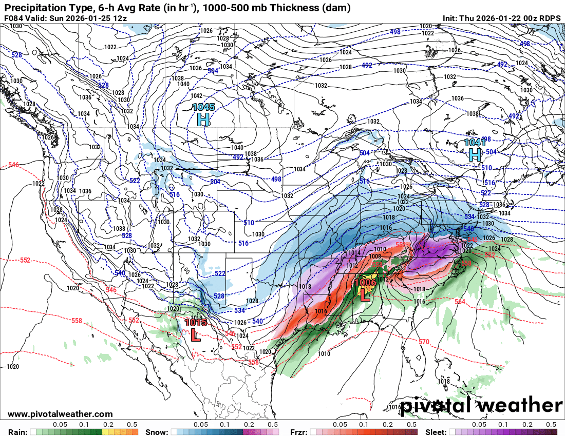
This feels like an old school ultra amped hour 84 RGEM run Even with it being well phased, the northern stream is bordering on suppressing it (especially on the NW flank) if the PV/high pressure ahead of the storm trend any stronger.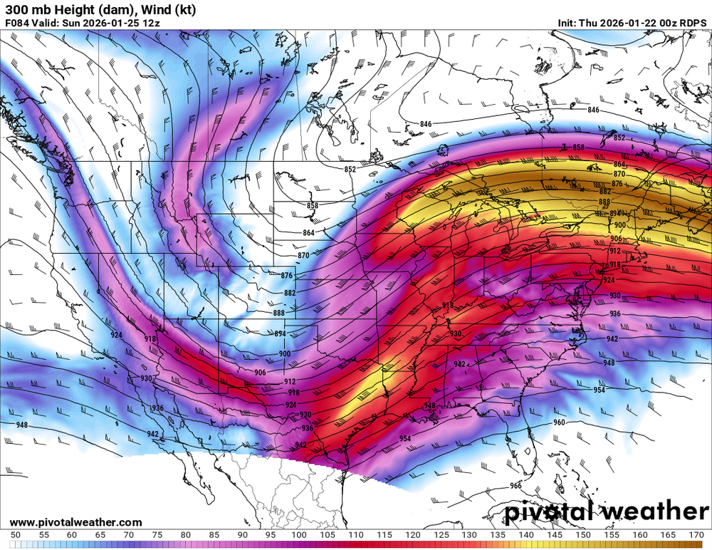

.thumb.png.a54a8339a27da543303c1b0f6006c603.png)
-
1/24-1/25 Major Winter Storm - S. IL, IN, and OH
OHweather replied to A-L-E-K's topic in Lakes/Ohio Valley
lol -
1/24-1/25 Major Winter Storm - S. IL, IN, and OH
OHweather replied to A-L-E-K's topic in Lakes/Ohio Valley
The NAM wants to phase better, but is also pressing the PV in a good bit more which suppresses things through at least hour 84… doesn’t mean much unless the global models have the same trend. -
1/24-1/25 Major Winter Storm - S. IL, IN, and OH
OHweather replied to A-L-E-K's topic in Lakes/Ohio Valley
It’s too bad the recon data didn’t hit the NAM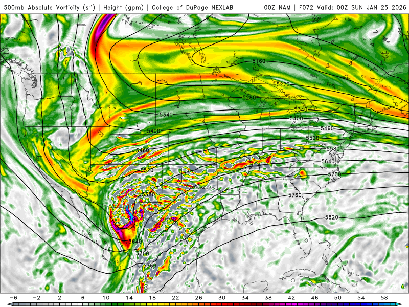
-
1/24-1/25 Major Winter Storm - S. IL, IN, and OH
OHweather replied to A-L-E-K's topic in Lakes/Ohio Valley
Yeah I agree those runs will be telling. All the other 12z models generally trended a bit slower with ejecting the Baja low too, but outside of the Euro which definitely bumped SE it wasn’t enough to overcome other trends that supported a more NW track on the other models. So there’s clearly a fair amount of sensitivity to relatively small changes with how that ejects out and phases. -
1/24-1/25 Major Winter Storm - S. IL, IN, and OH
OHweather replied to A-L-E-K's topic in Lakes/Ohio Valley
Worth noting that for reasons that are unclear to me, the NBM does not ingest all of the 0z Euro/EPS QPF until the 19z run (with the 12z hitting at 7z). Overall I have mixed feelings on the 12z runs. Trends to lift the PV out a bit quicker and for the northern stream diving into the Rockies to be more amped continued, but there was also a subtle trend to eject the Baja cutoff slower and/or not as cleanly, which would hurt the potential for an earlier/more aggressive phase. -
1/24-1/25 Major Winter Storm - S. IL, IN, and OH
OHweather replied to A-L-E-K's topic in Lakes/Ohio Valley
The airmass in front of this is quality and there will be quite a bit of CAD east of the Apps, so I think DC sees a cold/wintry storm even if Chicago cashes in, but ice/sleet are in play for them for sure. -
1/24-1/25 Major Winter Storm - S. IL, IN, and OH
OHweather replied to A-L-E-K's topic in Lakes/Ohio Valley
UKMET remains on board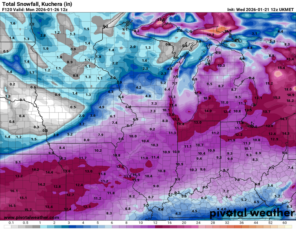
-
1/24-1/25 Major Winter Storm - S. IL, IN, and OH
OHweather replied to A-L-E-K's topic in Lakes/Ohio Valley
I guess that's not the worst model run I've seen for MBY -
Winter 2025-26 Medium/Long Range Discussion
OHweather replied to michsnowfreak's topic in Lakes/Ohio Valley
Pretty great trends at 500mb... The PV over the Canadian Maritimes is pulling out a bit quicker, the northern stream diving into the Rockies is definitely trending more amped (with more amped ridging over western Canada/Alaska), there's better phasing, and heights are rising more ahead of the storm..thumb.gif.f1659677f9a68d1cb399518cd7b5c8a0.gif)
-
Yeah, I think it’s fair to say ice will be a limiting factor for LES for the foreseeable figure. It should still be open enough for significant snow Sunday through the first half of next week, but a majority of that will probably go into western NY. There is a window Monday into Monday night for a more westerly flow to try to push lake effect into the northern portions of the primary NE Ohio snowbelt. Interesting signal for some convective snow showers with the cold front later tomorrow morning into the afternoon. Wouldn’t add up to all that much, but someone could get a nice snow squall.
-
A little over 3” of pure fluff at home during the day today, bringing my total to 9.6”. Would say the office had a good foot by the time I left…it was dumping most of the morning and early afternoon.
-
Had 6.4” at home at 7:15am, probably about 7” at the office in Brooklyn Hts and still in and out of heavy, fluffy snow. Great event, generally overachieving across the board. Another few hours through the early afternoon where activity should remain intense before it diminishes from west to east into this evenings
-
The traffic maps and cameras did not look pleasant.
-
Here is the storm total snow forecast from this afternoon through 7 PM Thursday (so just this ongoing event)...it was a big jump from prior forecasts, but still too low in the Toledo area and I suspect will be too low in locations downwind of Lake Erie from Sandusky points east. Coming up on an inch of snow, heaviest still off to the northwest. Initial signs of the first bit of lake enhancement near Cleveland on radar.
.thumb.jpg.ca1eb26ebc7cd17981fccd9c1ee3ca15.jpg)
-
Winter 2025-26 Short Range Discussion
OHweather replied to SchaumburgStormer's topic in Lakes/Ohio Valley
The models hinted at this on Sunday and then completely backed off, and never caught back up until the snow was almost over. Maddening as an operational met, splendid as a snow lover. My best explanation is that models were not properly initializing with the vort max that dove in from the Arctic, as everything associated with that (starting with the overperforming squalls in the Chicago area this morning) has over performed with this system. -
The uptick in the snowfall forecast over the last 24 hours has been remarkable, and some models still have more snow than what’s in the current NWS forecast. I am just leaving the office and it is snowing here, looking forward to a very snow next 24 hours!
-
Oh yeah, for sure. It's a little frustrating. Some of the observers really do try and come to a reasonable number, but it's hit or miss. Can say the same about most climate sites (but not all, there are some that are usually pretty dead on!). In better news, the 0z models have trended a little more amped with the system Wednesday afternoon/evening, bringing 1-3" of synoptic snow to north central and northeast OH through the evening (probably 2-5" of snow in the snowbelt through Wednesday evening with lake enhancement), with some component of snow squalls Wednesday evening even outside of the snowbelt. Beyond that, it seems like a situation where fluffy lake effect/enhanced snow performs well through Thursday afternoon, especially in the higher terrain. Road conditions will probably be very shitty Wednesday evening and night with snow showers and squalls along with gusty winds and plunging temperatures.
-
It’s the measuring at the airport. It seems like if there’s any reason for them to struggle (snow quickly melts after it falls, snow is blowing around, etc) they will come in lower than immediately surrounding obs. I don’t think it’s intentional (if it’s cold and not windy they’re usually ok) but it’s been consistent for years. Looks like some more snow late Wednesday into Thursday, with a little shortwave crossing late Wednesday ushering in some NW flow lake effect. Doesn’t look like a crazy setup, but will definitely freshen things back up after a couple of milder days.
-
Definitely was a surprise this morning! Measured 3.6” at 10am, have had enough since then that my event total is right around 4”. That squall early this morning wasn’t really lake enhanced either, I was sleeping but based on radar and how much fell it must’ve been dumping for an hour or two.
-
Winter 2025-26 Medium/Long Range Discussion
OHweather replied to michsnowfreak's topic in Lakes/Ohio Valley
The pattern the next week or so is pretty awful...massive trough over Alaska and near the west coast of Canada. But the ensembles have consistently suggested a ridge from just off the west coast into Alaska returning around mid January, with some cross polar flow into a deepening trough centered near Hudson Bay. The imminent torch will scour a lot of the cold air out of North America so the pattern likely won't immediately flip to something extremely cold after mid month (will take a little time for true arctic air to return), but some semblance of winter should return in 10-15 days if this look (which is pretty consistent across the Euro, GFS, and Canadian ensembles) is close to correct. Euro ensemble: GFS ensemble: Canadian ensemble:.thumb.png.fcaef1b7cf627f0d1d948e1e92430f78.png)
.thumb.png.f7b59d099fa82d6d3e30d8fccb9849b4.png)
.thumb.png.f28389c1bdfc5b949e4921ab349addeb.png)
.gif.e44f1c254ef807276a9242e4f2f799f0.gif)
.gif.4e00a1d802c3cce6aff4d98f7ffd86f7.gif)



.gif.9ed2cf3b18c9304e5a2f2731d722ea88.gif)
.png.d656613b68f1a683aedb893bbac51f78.png)

.gif.16000c1f226d14be554b1d4881c7876d.gif)
.jpg.c3b589131ab507fabe049f8d55a4138f.jpg)
.png.488bcdbfa7f11c353516d659195cc4e7.png)
.png.7b7d8f907e74fed76d730ed6442c2a06.png)
.png.49ea36c884ab8280b5084a379f940ff6.png)