OHweather
Meteorologist-
Posts
5,044 -
Joined
-
Last visited
Content Type
Profiles
Blogs
Forums
American Weather
Media Demo
Store
Gallery
Everything posted by OHweather
-
Models have trended towards swinging the winds around to the WNW a bit quicker over the last day or so…suspect the lake effect will struggle to push south of Lake County and far northern Geauga until late Thursday, but then there’s a pretty prolonged and decent WNW flow setup Thursday evening through most of Friday. Should be a solid setup for eastern Cuyahoga into Geauga and through the rest of the inland snowbelt. I could see the lakeshore struggling given the very strong winds over the water and fairly quick wind shift to WNW, but there may be a smaller area where banding sits on Thursday along the lakeshore (possibly in Lake or Ashtabula Counties) that does quite well.
-
Have gotten 2" so far, with 1.7" of that last night into this morning. This event has been pretty whelming if not on the underwhelming side. A few spots did ok, it looks like Geauga County did decently this evening. However, the carpet bomb winter storm watch for 5-10" did not work out.
-
11/8-11/10 First Snow and Lake Effect Event
OHweather replied to Geoboy645's topic in Lakes/Ohio Valley
-
11/8-11/10 First Snow and Lake Effect Event
OHweather replied to Geoboy645's topic in Lakes/Ohio Valley
Yeah it seems like they're alluding to it in their AFD as well. It may be hard to know exactly which way it'll go until the mesolow pushes farther inland/weakens a bit over the next few hours, as that's when the band will be more free to whip west, which it will still want to do based on radar trends farther up the lake. However, the shorter the window for that to happen the better for getting the band to stay more coherent. -
Some light accums have taken place in northern Summit over the last couple hours. On the board!
-
11/8-11/10 First Snow and Lake Effect Event
OHweather replied to Geoboy645's topic in Lakes/Ohio Valley
I don't think the band taking slightly longer to swing west is a bad thing for the immediate lakeshore/Chicago area (and probably ups the odds at someone getting a higher-end total)...some earlier model depictions had it swinging west and breaking into weaker multi-bands pretty quickly (before congealing as it swings back east on Monday). This slower west push right now may allow for a more focused band that lasts longer close to the lake later tonight. -
Well, it turns out the AI models were on to something with that southerly low track. Saw that Toledo got a nice little thump of moderate to heavy snow with accumulation this morning. As for the LES, this remains a tricky forecast with the amount of instability providing for potential upside, but a lack of band persistence/organization evident on models is a potential significant limiting factor. Starting tonight, (mainly light) synoptic precip with some northerly flow lake/upslope enhancement this evening will give way to more classic lake effect precip after midnight. Conditions will become quite conducive to lake effect by early Monday, with lake-induced equilibrium levels climbing over 10k feet overnight and BUFKIT displaying "extreme" instability by sunrise, with lake to 850mb temp differentials of over 20C and lake to 700mb diffs of around 30C. Lingering synoptic moisture should be fairly abundant in the lowest 10-15k feet much of the night. We should see rain mix with and gradually change to snow this evening in the Cleveland area with the higher terrain going first. It will get cold enough for accumulations by late evening or the overnight under any organized bands, especially inland. There are suggestions of a potential Lake Huron connection setting up well west of Cleveland tonight...with some enhancement near Cleveland into the Medina/Lorain County area also hinted at most of tonight. Farther east, there could be some less organized lake effect/upslope precip overnight into early Monday. I think most of the area will see a light accumulation tonight, though near the lake may not see any stick outside of any localized heavier bands. Snow rates within bands could top an inch an hour overnight but bands may be moving a bit too much...however, a slower moving band would be the opportunity for locally a few inches tonight into early Monday. Winds will shift from N to NW through the day Monday, with a patch of subsidence and drier air working through during part of the day. Lake Huron enhancement will swing east across the Cleveland area and into the Snowbelt on Monday. It will still be quite unstable on Monday so this band may still be heavy at times, but activity outside of any Lake Huron connection could be pretty limited on Monday and accumulations will be harder to come by during the day outside of bands. So, I could see some localized amounts of up to a couple inches during the day Monday, mainly with any activity enhancement by Lake Huron. The most ideal window looks like Monday night into early Tuesday. The core of the closed low/cold core aloft will move right over Lake Erie Monday evening, with NW winds gradually shifting more W Monday night. Conditions will be very conducive to intense LES the first half or so of Monday night...they gradually decline later Monday night into Tuesday, though heavy snow in bands should be supported into early Tuesday at least. The main target Monday night will be the Lake Huron connection, which may settle into NW PA for a good chunk of the night. However, a couple of other bands will likely play out across the Snowbelt and Cleveland metro. Bands may again move just enough Monday night to keep amounts somewhat under control, though could see additional 6-10" amounts in PA if the Lake Huron connection is stable enough, with locally several more inches across parts of NE Ohio under more organized bands.
-
The AI models have seemed to do well with picking out trends ahead of time. In this case, the low doesn’t look like it’ll be well phased with the incoming lobe of the PV and some of the numerical models and ensembles have shifted a bit farther south. So I don’t think the southerly track is off the table. But I do think that if it trends much farther south it also trends weaker, which could really limit any snow potential in such a marginal airmass.
-
Yeah, this is looking quite interesting still. There are still some disagreements on the synoptic setup, the GFS is a bit more progressive and would maybe limit the high-end potential, though the Euro and Canadian are more amplified and bring the core of the 500mb cold pool over or near Lake Erie Monday into Monday night...which could allow for a very fun event. It seems like lake enhanced/effect precip ramps up Sunday evening as we get into cold advection behind the departing low pressure. The flow will be northerly at this point, with some sort of Lake Huron enhanced band likely taking shape west of Cleveland initially. There could also be some disorganized showers/upslope into the higher terrain of the snowbelt. Instability isn't anything too extreme at first and the deeper cold air doesn't arrive until overnight, so accumulations may be marginal through Sunday evening. Activity should get more intense and accumulate more efficiently, even close to the lake, overnight into Monday morning. There's good agreement that the broad cyclonic flow will persist but gradually back to a more westerly direction Monday through Tuesday. It will be northwest on Monday, more west-northwest Monday night, and probably more west or even west-southwest on Tuesday. This will likely pivot any Lake Huron band east across the Cleveland metro and secondary snowbelt during the day Monday and into the primary snowbelt by Monday night, with perhaps a W-E band flaring up Monday night into Tuesday east of Cleveland while the Lake Huron band pivots east across Ashtabula County and Northwest PA. The global models don't have the resolution to resolve such features, but they seem to be hinting at some strong shoreline convergence or perhaps a mesolow of sorts evolving near or just offshore of Cleveland on Monday, which could be intriguing. Where the uncertainty lies is in mesoscale details, such as where upstream connections set-up, how our shoreline convergence behaves, and if a mesolow forms on Lake Erie. That will heavily dictate how organized any banding is and where it develops. With the flow slowly shifting from NNW to W or even WSW through the event, it has the potential to really spread the wealth. The potential exists for extreme instability, with fairly good synoptic moisture and support, especially if the trough is on the deeper side like the Canadian or Euro, which could allow for very impressive snow rates and double digit totals...the GFS would be ok, but it's not quite as good. Temperatures will be somewhat marginal, but by overnight Sunday night and through Tuesday morning should be cold enough that organized bands will be intense and able to accumulate. The higher terrain inland will accumulate more readily, but under good bands it should accumulate close to the lake. Should be a fun event to track! I'll actually be down in Athens Friday and Saturday so won't be forecasting this in an official capacity, but I'll be back in town before the event starts and may actually get some snow at my house!
-
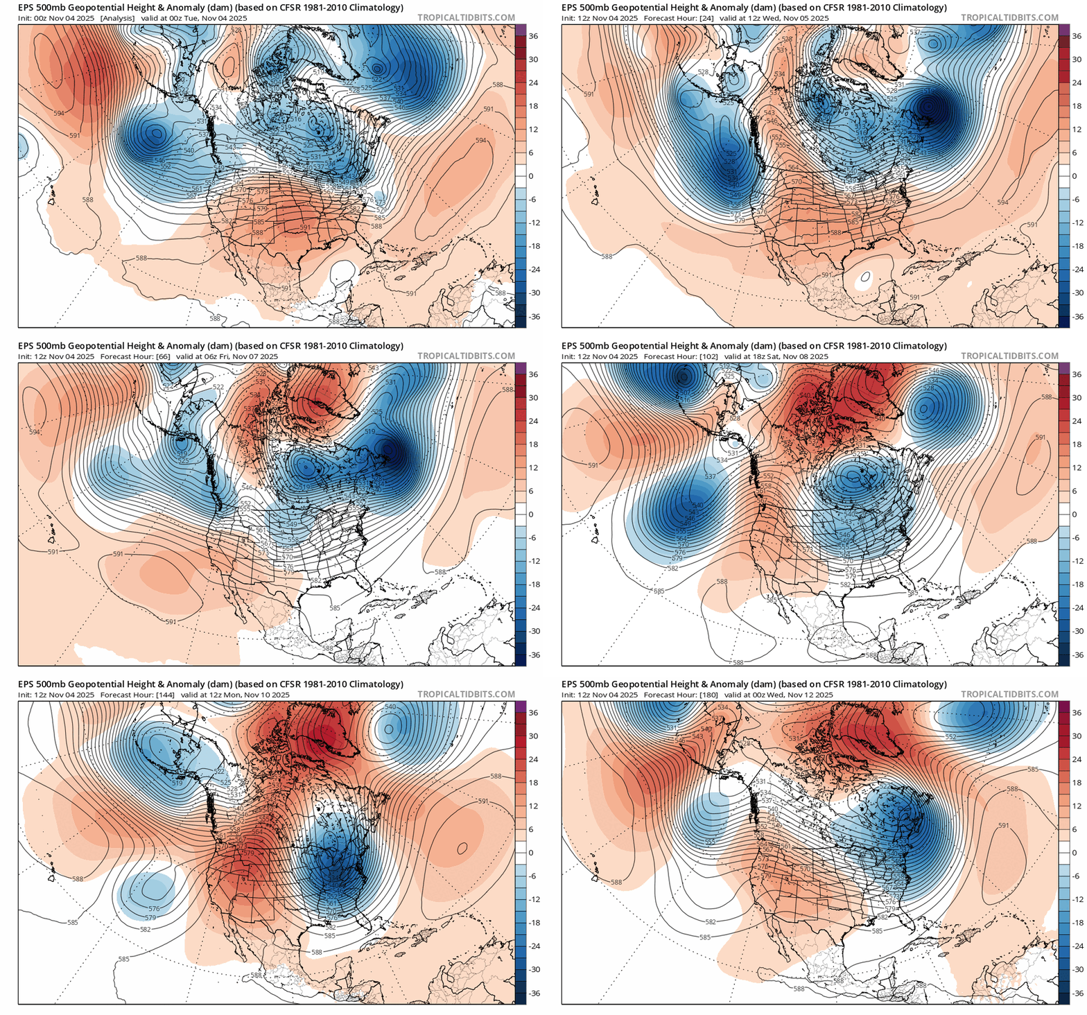
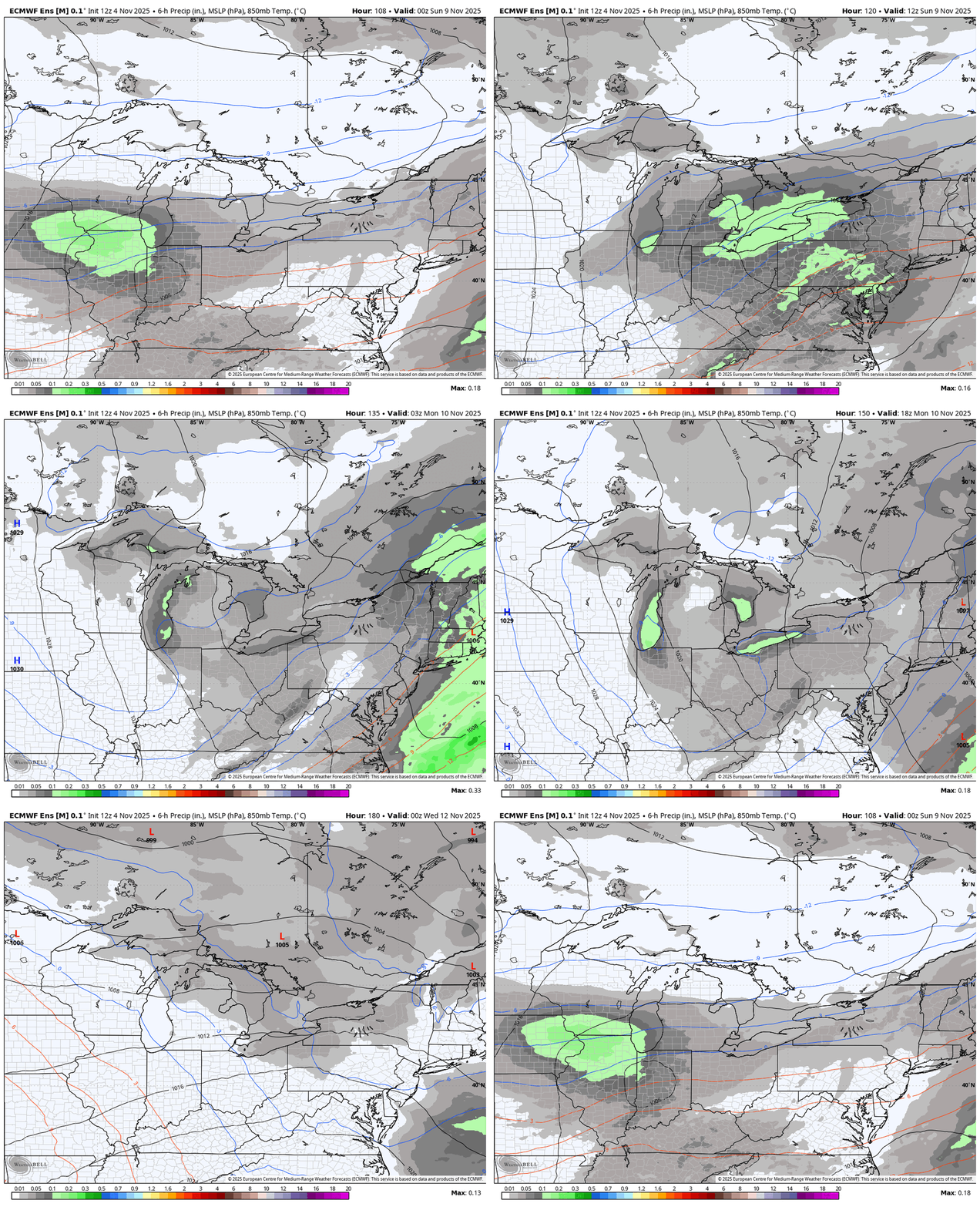
At this point, I am definitely "in" on accumulating snow somewhere across the snowbelt to start next week. It is short lived, but there will be a nice pattern amplification this weekend into the beginning of next week. That will send a chunk of the PV currently up over the arctic circle south into the Great Lakes Sunday and Monday: While details are of course going back and forth on the latest deterministic model runs as they will at this range, the ensemble mean SLP, 850mb temperature, and QPF loop is a pretty good look for lake effect: There may be some wet snow with that little wave of low pressure on Sunday depending on where it tracks...however, the lake effect ramps up behind it Sunday night into Monday, and probably lingers into Tuesday before ridging and warm air advection really start kicking in. Ensemble mean 850mb temps are down around -9C on Monday, with the ensemble mean depicting nice cyclonic flow across the Great Lakes and suggesting a more west to northwest wind direction. 500mb temperatures are progged to bottom out between -35 and -40C over a lake that is currently about 12C, which suggests very strong and deep instability is in play, potentially enough for thunder and lightning. We'll need to see how the specifics evolve as it gets closer, but the ingredients are there for a (somewhat brief) period of intense lake effect centered around Monday of next week, and the airmass should be cold enough for accumulating snow if we're able to get any sort of organized activity...which seems likely.
-
Fall 2025 Medium/Long Range Discussion
OHweather replied to Chicago Storm's topic in Lakes/Ohio Valley
It doesn't last long because the Pacific is moving way too fast right now, but a nice pattern amplification this weekend into the beginning of next week. You can see the chunk of the PV at the beginning of the loop up in the middle of the arctic circle that drops towards Hudson Bay this week and gets pulled into the Great Lakes and New England Sunday through Tuesday. It will be impressively cold aloft beneath this, so the lakes will be cranking. Pretty good chance that there's enough snow to prompt at least winter wx advisories off a few of the lakes, usually when it's as cold aloft at 500mb as what the models are depicting and the lakes are this warm there are some intense bands. -
I finally tallied up my snow logs from last winter...67.8", with the highlight being 34" in January. Core summer felt short this year, with chilly weather to start June and a decent stretch of sub-70 highs with lows in the 40s/50s to end August.
-
March 14-15 Severe Weather Outbreak
OHweather replied to HillsdaleMIWeather's topic in Lakes/Ohio Valley
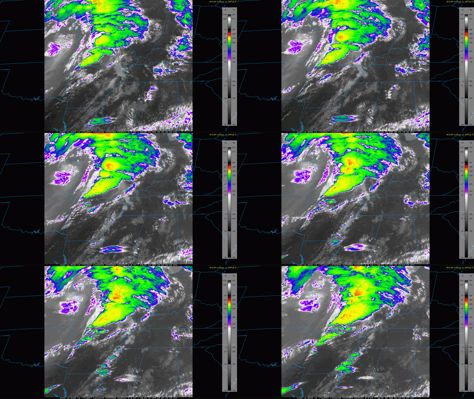
I think the SPC has done a pretty great job with handling the watches so far, starting with severe watches, then a couple of non-PDS tornado watches, and now a PDS tornado watch as the threat clearly ramps up as semi-discrete supercells evolve across parts of northern AR and central/southeastern MO. The strongest forcing is across the Upper MS Valley with the strongest instability confined towards the Lower MS Valley. Activity that evolves across east central and southeastern MO, north central and northeast AR, central and southern IL, and western KY will be in the sweet spot of more moderate forcing and instability with extreme shear, giving an opportunity for semi-discrete cells to persist in a kinematic environment that supports strong tornadoes with sufficient (certainly not outstanding) thermodynamics. Activity in MS is more weakly forced and is playing out amid a moisture-rich low-level jet. While the storm mode is currently semi-discrete and the shear supports an intense tornado threat, low-level lapse rates are weak with the low-levels fairly moist. This could keep storms somewhat messy and keep many from taking off and taking full advantage of the low-level shear. While there is certainly a tornado threat (potentially strong) all the way into MS and northwestern AL this evening and tonight, the northwestern half of the PDS watch will probably be most under the gun with more uncertainty towards TN, MS, and AL. -
March 14-15 Severe Weather Outbreak
OHweather replied to HillsdaleMIWeather's topic in Lakes/Ohio Valley
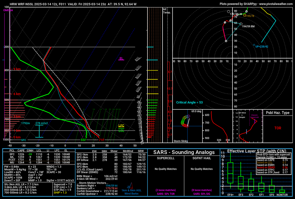
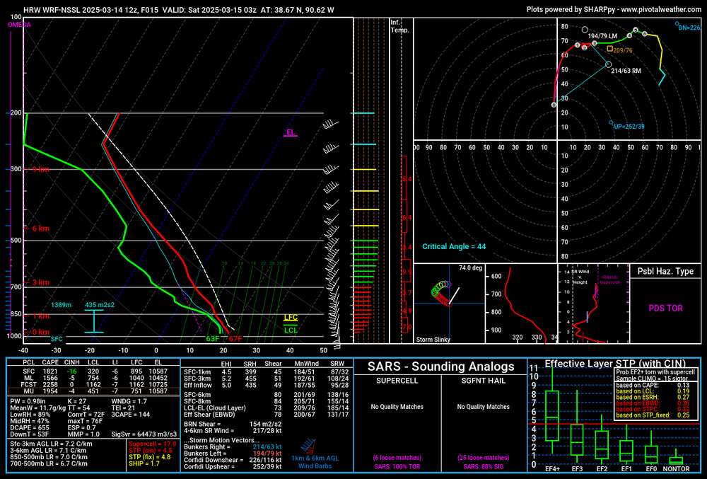
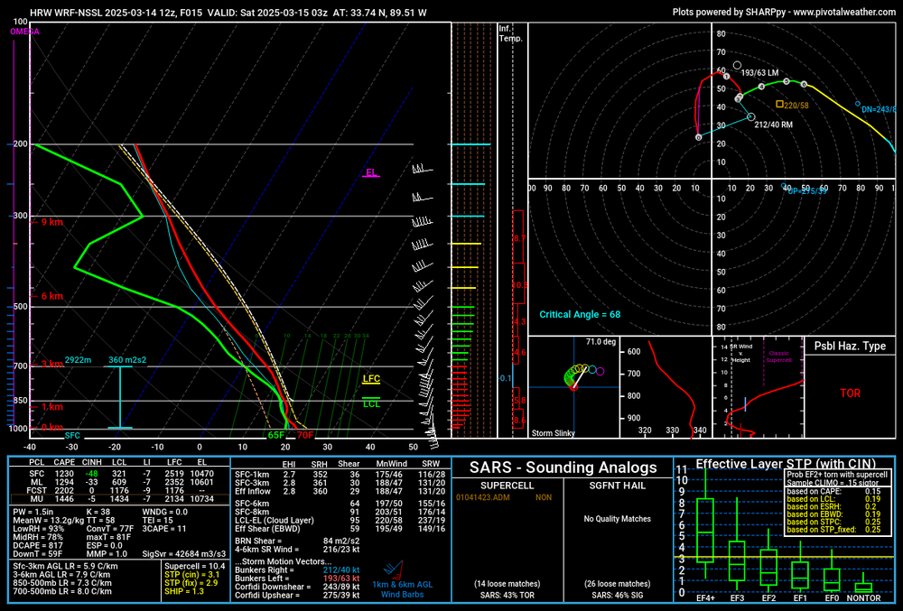
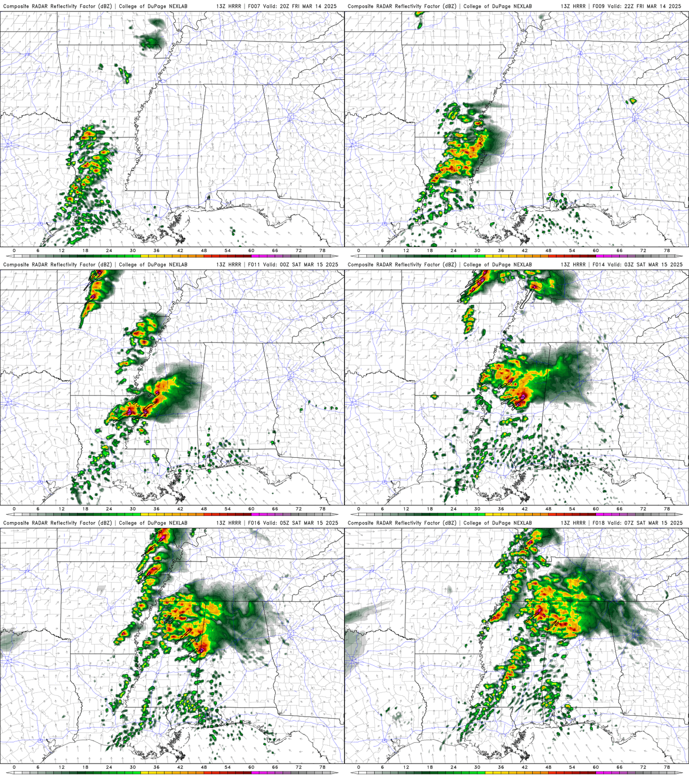
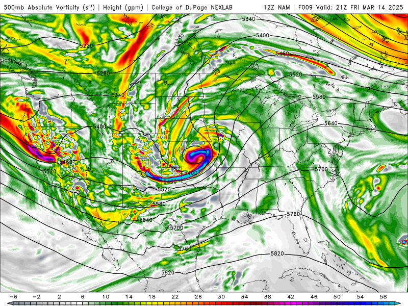
There will probably be a shit load of tornadoes from central and eastern MO into western and central IL, with the threat for stronger tornadoes probably maximized in the vicinity of St Louis later this evening. There will also be a ton of straight-line wind damage. A secondary threat for potentially stronger tornadoes is evident from MS into northern/western AL as well later this afternoon/evening. Pretty impressive model agreement on either a line, or a mixed arc of bowing segments and some embedded semi-discrete supercells evolving from MO into IA and IL this afternoon and evening, with some tendency for more cells towards the southern end of that. Some models keep this activity semi-discrete (or at least maintain decent line breaks) through much of the evening, especially into central/southern IL. This activity will be extremely strongly forced. Most CAMS other than the 3km NAM have a cluster of more weakly-forced convection developing from eastern AR/LA into MS and western/northern AL. Evolutions vary a bit more with that activity, likely due to weaker forcing. There likely will be a relative minimum in severe/tornado potential centered on western TN between these two areas, though some models have more isolated activity trying to play out even there. 3km NAM: HRRR: ARW: NSSL: They look slightly different but all agree on the overall evolution in both regimes fairly well (sans the NAM in Dixie today). No model is handling the current elevated convection great, though after 20z I kind of like the HRRR's and NSSL's reflectivity and overall evolution just a bit more than some others. You can get the idea that the northern activity in MO/IA/IL is much more strongly forced than the Dixie activity today: Something to keep in mind, the 500-700mb jet doesn't really punch into the warm sector in the upper Mississippi Valley until after 0z...so, shear profiles will already be impressive this afternoon and will improve markedly after 0z...500mb: 700mb (which is roughly 3km, so think of your 0-3km bulk shear vector for bowing segments and mesovort tornado potential, along with your 0-3km SRH). Low-level shear will be strong in the warm sector this afternoon and explode starting right around 0z this evening: Activity in the Deep South will be driven largely by a rich low-level jet, though even some of that lifts into the upper Mississippi Valley after 0z: The strong forcing argues for quick upscale growth in MO, IA, and IL this afternoon and evening, and most of the CAMs above do have a more linear mode than cellular. However, most do have hints of a more semi-discrete mode from east-central MO across central/southern IL and perhaps into far west-central IN. It is in this area where for several hours after 0z the bulk shear vectors are oriented 30-45 degrees across the expected convective line, which does argue for right-moving cells. The forcing is also a bit weaker farther south, which could assist in maintaining a somewhat more discrete mode: Some maybe representative soundings...from North Central MO late this afternoon: The shear is quite strong and the thermodynamics are sufficient for severe weather and not prohibitive for tornadoes...however, the thermodynamics could be better and the low-level flow is fairly unidirectional. East-central MO later this evening: While the low-levels aren't extremely unstable they're unstable enough, with 1500 J/KG of MLCAPE being fully sufficient for significant severe weather and tornadoes. The low-level flow could still be more backed (and may locally back more than this), though even without it the increased low-level shear after 0z increases effective SRH notably. Any bowing segments in this environment would be capable of swaths of sig wind damage and tornadoes as well...however, the main concern is if semi-discrete cells interact with this environment as some signs point to. Strong tornado potential is evident, though there are subtle limitations which may keep the ceiling for this event from blowing into the stratosphere. Here's a look at a sounding in central Mississippi this evening: Upon clicking around several of these soundings to find representative ones, I found the low-level shear to be best in the Deep South. However, the low-level lapse rates are quite weak with richly moist low-levels. That could be a limiting factor for greater tornado potential...however, the fact that most CAMs have discrete or semi-discrete cells playing out in this environment suggests tornado (potentially strong) potential, even if there are limitations. Overall, I would suggest patience. Storms will probably be severe with scattered to numerous straight-line wind reports, scattered hail, and a few tornadoes this afternoon in MO/southern IA...the northern threat likely maximizes starting around 0z, with potential for somewhat more discrete activity on the southern edge of that from east-central MO into central/southern IL. The environment this evening will support widespread/significant wind damage with any bows, along with QLCS tornadoes, with any supercells capable of all hazards including strong tornadoes. The tornado threat will gradually decrease with northern/eastern extent into IA, northern IL, southwest MI and across IN, though given the strong low-level shear QLCS tornadoes can't be ruled out where any surface-based CAPE persists overnight, assuming some organized convection can persist. There may be a relative min in severe coverage in the vicinity of western TN, with a secondary threat area focused on MS and western/northern AL. This southern threat area has tornado (potentially strong) potential, but with some overall limitations. I think east-central MO into central/southern IL has the greatest severe wx and intense tornado potential overall today and tonight, though there is a much broader area with severe/some tornado potential across MO/IA/IL/southern WI/southwest MI/IN. I could see the coverage of tornadoes and EF-2+ verifying a small 30% hatched area in practically perfect verification in the MO/IL vicinity, though some questions about storm mode, the low-level thermodynamics, and about how backed the low-level flow will be probably puts a lid on how many tornadoes stronger than EF-2/3 we can see out of this setup, which probably argues against them pulling that trigger. 10% hatched into the Deep South seems warranted given obvious strong tornado potential given the low-level shear and expected storm mode but questions about the low-level thermodynamics.- 248 replies
-
- 16
-

-

-

-
The light, fluffy, gradually accumulating lake effect will not quit. Another 1.8" yesterday and last night, bringing me up to a 36 hour total of 4.3". Probably will get another inch through this afternoon the way the radar looks. The office had to upgrade inland Erie PA to a LES Warning last evening, and it looks like several spotters have 6-11" of snow since early Thursday. So much for the frozen lake!
-
I did better than I thought I would into this morning, already 2.5" of very fluffy snow here. See a report of 3.5" near Garfield Heights. Looks like some localized lake enhancement.
-
Sort of an interesting snow event Thursday into Friday with a slow-moving low-level trough axis bringing light synoptic snow showers, with lake enhancement south-southeast of the flake. Should be a general light accumulation, with several fluffy inches in the higher terrain of the snowbelt.
-
Got a little under 3” with the synoptic snow through early afternoon and about 2” more with the lake enhanced snow this evening. Probably will get a bit more overnight and it’s blowing around a fair bit right now. Not a bad little event.
-
About 1.5" of snow with part 1 this morning...nothing crazy but it snowed decently for a couple of hours. As for part 2, not a huge storm, but most of northern OH looks to get a quick few inches of snow after the changeover this morning, with blowing snow and some lake enhancement lingering through much of tonight on a WNW wind into the primary snowbelt, Cleveland metro, and northern secondary snowbelt. The higher terrain of the snowbelt could see over half a foot of wind-blown snow by daybreak Monday.
-
Interesting pattern. Maybe some snow squalls Thursday evening on the leading edge of the stronger cold air advection. Models have ticked NW for the weekend storm, but it still looks like an interesting system. Should be some front end snow late Friday night into Saturday, a period of rain Saturday afternoon into Saturday night, changing to at least light synoptic snow late Saturday night and Sunday as the low pulls away. The lake is mainly frozen but there should be some enhancement Sunday through Monday with north winds gradually shifting more westerly. It will be windy Sunday into Monday so any snow accumulations will blow around on the backside of the storm.
-
What's fun is that the FAA's full time meteorologists are technically NWS employees, and the NWS has a whole national center (the Aviation Weather Center) dedicated to aviation weather because of how obviously important and impactful it is to public safety and the economy. It's not the FAA personnel at the 21 air traffic control centers who want to get rid of the meteorologists based there, it's higher ups at the FAA, and they were closer than they should have been to getting their wish recently.
-
So, as an NWS met who routinely sends out climate reports for first order sites, including snowfall, this exchange was fascinating to me. We have 6 first order climate sites in our CWA that all measure snow. 3 are FAA contract observers, with the observers measuring the snow for the site. The other 3 are snow paid observers. The snow paid observers are trained to report trace depth and do so. The 3 sites with FAA observers do not officially put the Trace in their obs, however, they do note it in their logs. We call them every 6 hours to verbally get the new snow and depth and they tell us the traces. So needless to say, while I knew the T depth did not show up in the METAR and doesn't get pulled into our system, I had no idea that it's technically not a valid ob based on FAA standards that sometimes isn't reported.
-
Nice overperforming, fluffy lake effect event. I'm nearing 6"!
-
Looking back at mesoanalysis, there are some hints that there was a thermal gradient and some weak convergence at 700mb (which was right in the DGZ), so maybe that was enough, but it was a small feature and not modeled well. There was also some banded snow that got into the Canton and Youngstown areas that produced a few 4-5" reports. Otherwise, pretty meh. 1.4" here. I had the forecast during the day yesterday and the 12z guidance generally trended down somewhat with the QPF from prior runs, which was ultimately the correct trend. The radar had somewhat of a banded appearance upstream with a lot of sites dropping to 3/4 mile or less visibility so I was apprehensive to lower our snow much (especially since we already had an advisory out for most of the CWA), and we did have those two small areas of banded snow that produced a few inches, but otherwise this was a very boring synoptic snow that came in on the low end of expectations...though it was widespread at least and freshened up the pack a bit.
-
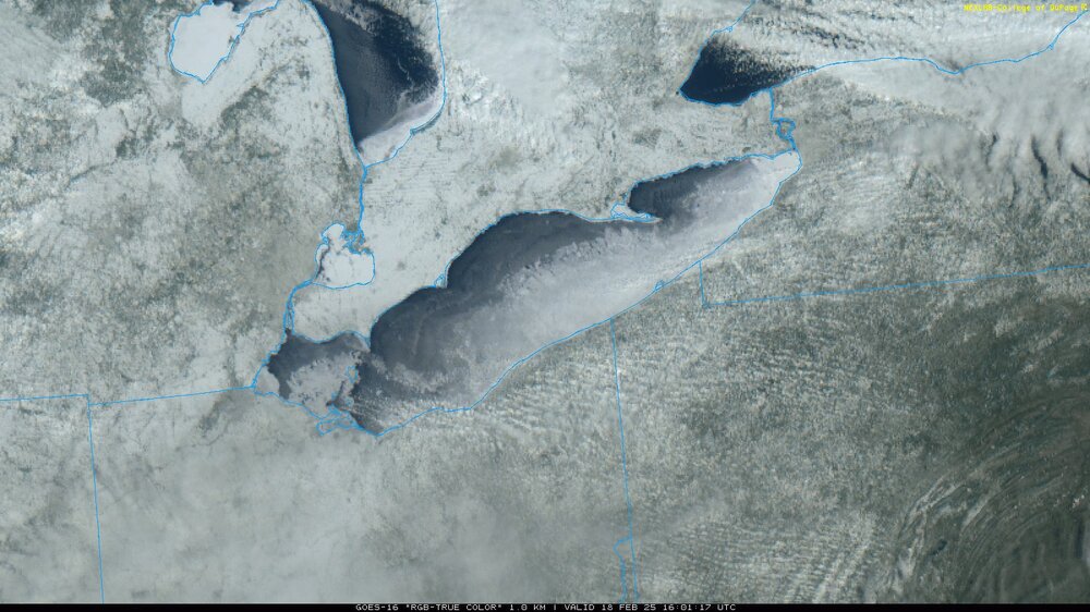
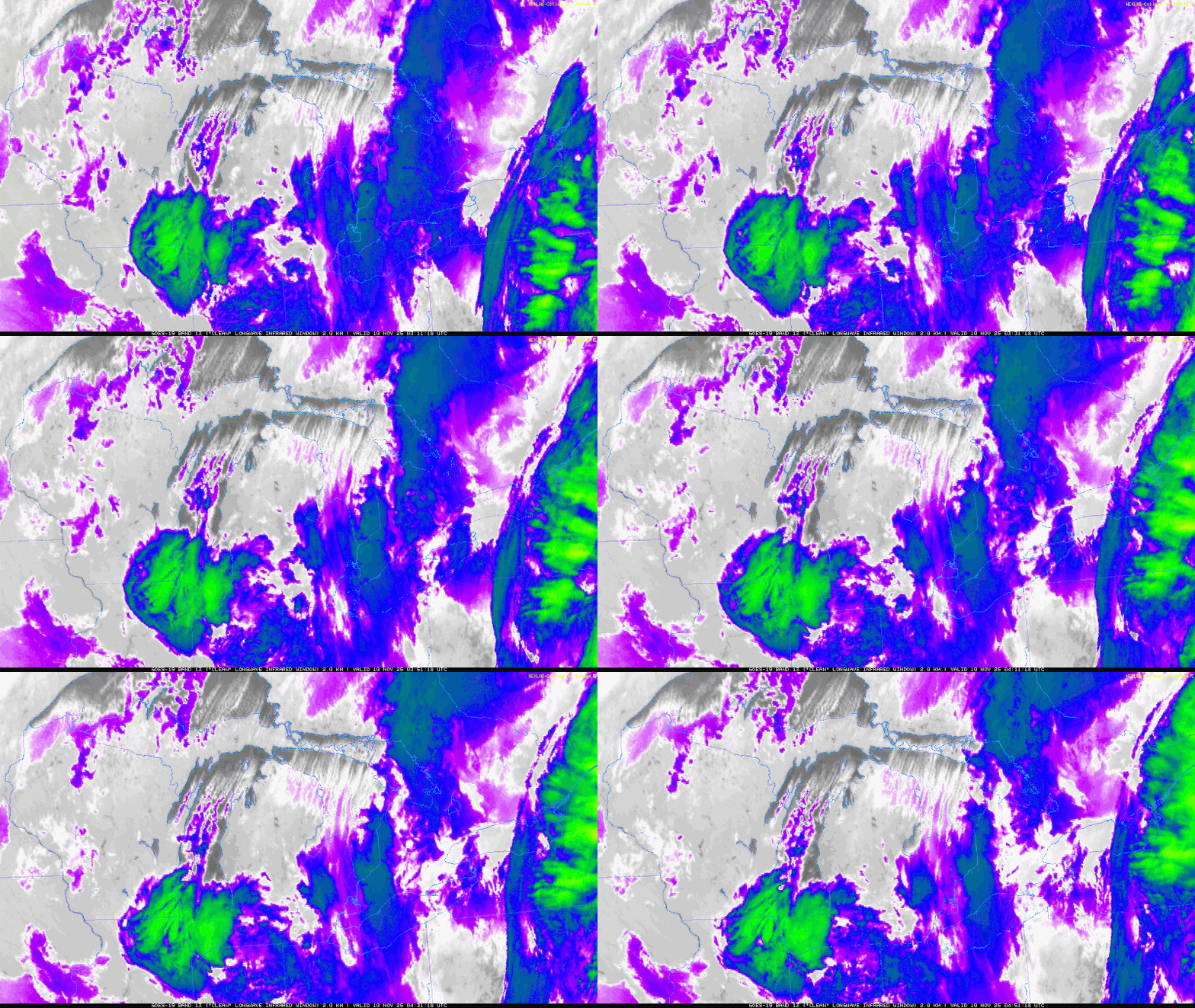
Got another 3" of fluffy snow yesterday into last night, though it seems to finally be done for now until we get our quick hitting synoptic snow later Friday. I'm at over 20" of snow for the month of January so far (about 22" by my quick math). Satellite confirms that ice in the western basin...pretty much completely frozen west of the Islands, with a decent area of ice along the southern shore east of the islands. Most of the central and the entire eastern basins are open, but ice will continue gradually expanding for the foreseeable future.


.gif.9e0adb249e3138f87a27876fab481a92.gif)
.gif.dbbaa30bacc98bd138d635065ecfe30c.gif)
.thumb.gif.4221e1f980b1372526a1c9e21dfe23d3.gif)
.thumb.gif.ac6f9d3afabde141a19e48132fdd0171.gif)
.gif.d32a847d0c8616a3cf600b6e10a2472a.gif)
.gif.a0fa175fa6cf321f9fa9146d73b1613f.gif)
.thumb.png.9a33d320804c48deabbf445a98fc3e70.png)
.png.c23c9db95b3fcb355da88c48319bc7fa.png)
