

OHweather
-
Posts
5,046 -
Joined
-
Last visited
Content Type
Profiles
Blogs
Forums
American Weather
Media Demo
Store
Gallery
Everything posted by OHweather
-
Bit of an out of nowhere kind of lake enhanced snow setup for Sunday. Certain things that look good, a few question-marks. A closed low dropping across eastern Lake Erie into northern PA on Sunday is a good start synoptically. Conditions maximize for several hours downwind of Lake Erie from mid-late morning through much of the afternoon tomorrow...with favorable conditions lasting a few hours longer into the evening farther east into NW PA. In this window, forecast soundings show the unstable layer over the lake deepening into the DGZ as EL heights climb, with an isothermal layer and weak synoptic lift above the unstable layer giving a period of rather deep snow growth. It'll snow pretty good in the upslope areas for several hours as this happens. Synoptic moisture pulls away quickly into Sunday night with temperatures aloft starting to warm too, so expect snow to wind down pretty quickly into Sunday night. It's a somewhat brief window and won't be super cold, with the best snow definitely happening during the daylight on Sunday in mid-March. I still think it'll accumulate but a little colder or more snow falling at night would've been ideal. I think in northern OH, a lot of areas from north central OH points east will see 1-3" of snow, increasing to 2-4" in the metro area and hills of the secondary snowbelt and 3-6" across the higher terrain of the primary snowbelt. Less right next to the lake. It's certainly possible that the preferred WNW flow lake enhanced upslope areas in eastern Cuyahoga and northern/central Geauga see a small area of 6-8" type amounts. Into PA the snow probably will also focus in the higher terrain inland, though with a slightly longer duration and more terrain (and slightly more favorable soundings overall) so I think it's a more solid 6-10" with perhaps some locally higher amounts in the higher terrain of NW PA, especially in the eastern half of Erie County extending into SW NY. To me this feels like a warning event for inland PA and more of an advisory event for the NE OH snowbelt (despite potential for a local 6-8" bullseye, I don't think it'll be super impactful), but the watch is out for Geauga so maybe you'll get a warning there. I'm off this weekend so it'll be nice to just watch it snow tomorrow. Even outside of the snowbelt, with the synoptic lift, WNW flow, and some Lake Michigan moisture there should be some decent snow showers with light accums all the way down towards Mansfield points east, so everyone should get at least a bit of snow.
-
Another 0.8” of fluffy snow during the day in Macedonia. My total is 0.8” of system snow and 3.0” of lake effect. A minor miracle this winter.
-
Had about 0.8” from the synoptic snow and another 2.2” from LES overnight through 7:15 when I measured. A burst just dropped 1.5” in about half an hour at the office.
-
While my optimism for the extended range has completely faded, it's worth noting that Saturday has the potential to be interesting for lake effect snow from in and around the Cleveland metro points northeast.
-
Winter 2023/24 Medium/Long Range Discussion
OHweather replied to Chicago Storm's topic in Lakes/Ohio Valley
The trend over the last few days on the ensembles for the last few days of February has been awful. Trending to a -PNA/+EPO and at best a neutral AO and NAO pattern. So the eastern 2/3rds of the CONUS will trend mild to end this month as cold gets scoured from Canada. That’s not to say it can’t or won’t snow at some point in March, but we’re done with anything sustained at this point. The active stretch in January was fun. The rest has objectively sucked, which is how winters seem to go anymore. -
I am way overdue on properly responding to this... Our bread and butter for snow is a polar jet dominated pattern with a lot of clippers and lake effect. An occasional panhandle hook/Colorado low and rare low from the Gulf can give us one or two larger storms a winter, but we get snowy seasonal totals when we get stretches where it just snows a lot and adds up. We have not had that for more than brief stretches in recent winters, despite a few impressive synoptic snows. I think some of the things driving our recent lack of snowy winters are cyclic, while others are related to longer term trends. I think the NAO is somewhat cyclic, with stretches where it's predominantly positive historically. We may be coming out of the ongoing stretch of +NAO...but it has contributed to the recent lack of snow. I also think the PDO is somewhat cyclic. A strong -PDO favors a SE ridge, while a +PDO favors a +PNA. A -PDO is a wetter pattern, but the +PNA isn't always optimal for us (sometimes the trough ends up a bit too far east). A -PDO, though, can just be mild/rainy. The warming Indian-Pacific warm pool is a longer term trend, and it probably does favor more active convection in an area that tends to favor mild weather for us. In some winters, that can result in periods of -EPO blocking which can result in nice Arctic blasts, but it also runs a -PNA and southeast ridge risk. I do think that could lead to an overall decrease in snow averages locally, but I also think there are other factors that are more cyclic and should break more favorably at some point soon.
-
If you want a local hot take, CLE will more than double their current seasonal total over the remainder of winter. That isn't saying a TON, but I don't think we've seen half our snow yet for the season. The next several weeks will be more wintry. While I'm not convinced it'll be the snowiest pattern ever, it will snow occasionally with generally chilly conditions.
-
Winter 2023/24 Medium/Long Range Discussion
OHweather replied to Chicago Storm's topic in Lakes/Ohio Valley
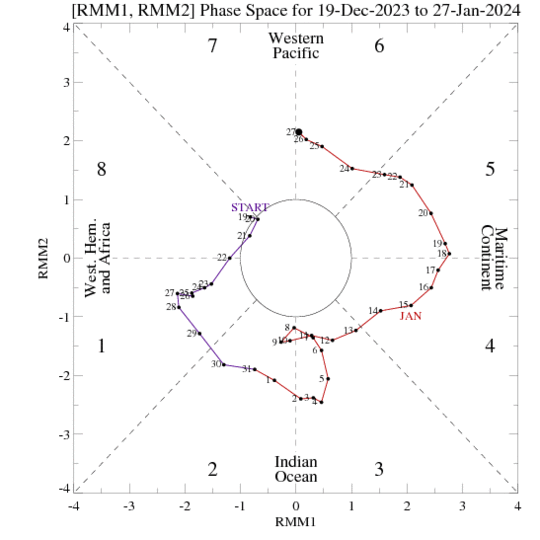
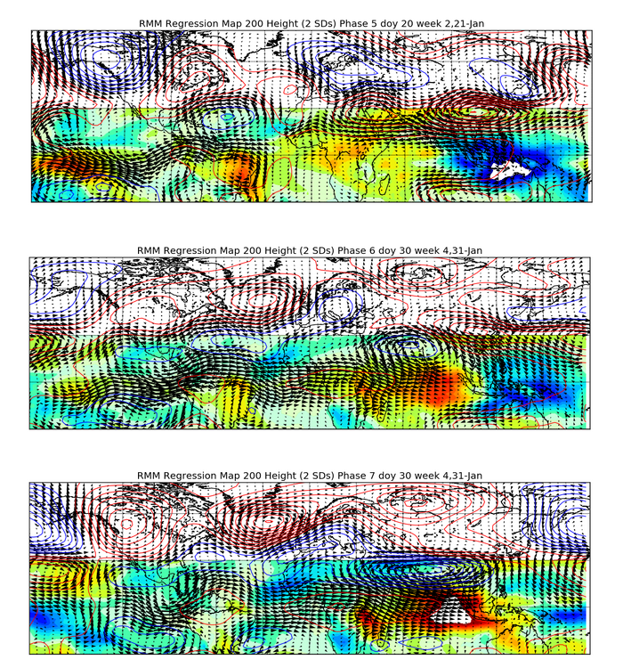
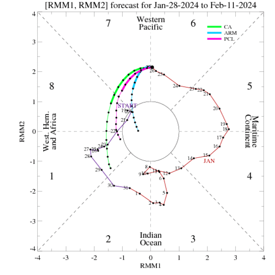
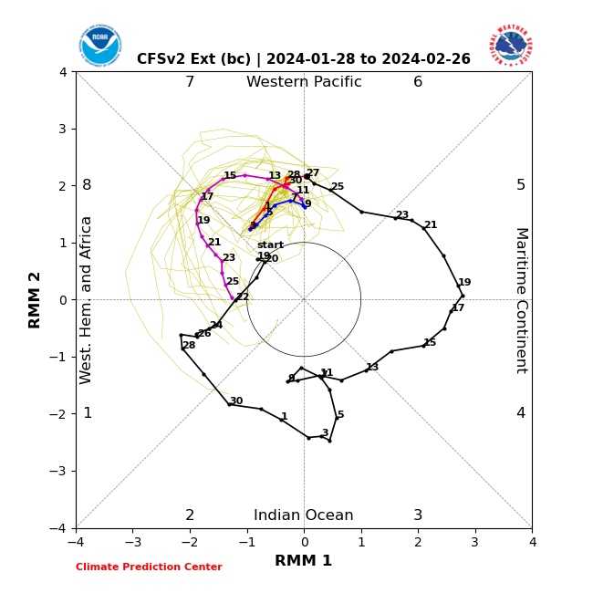
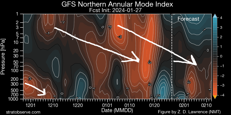
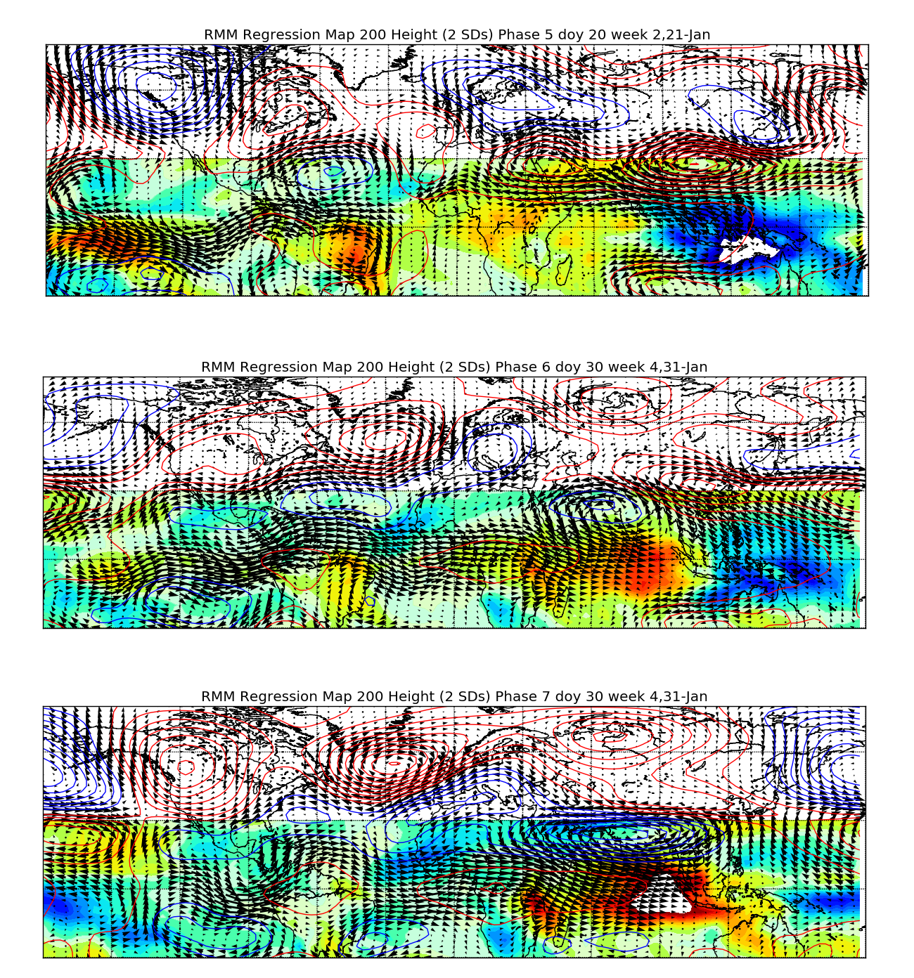
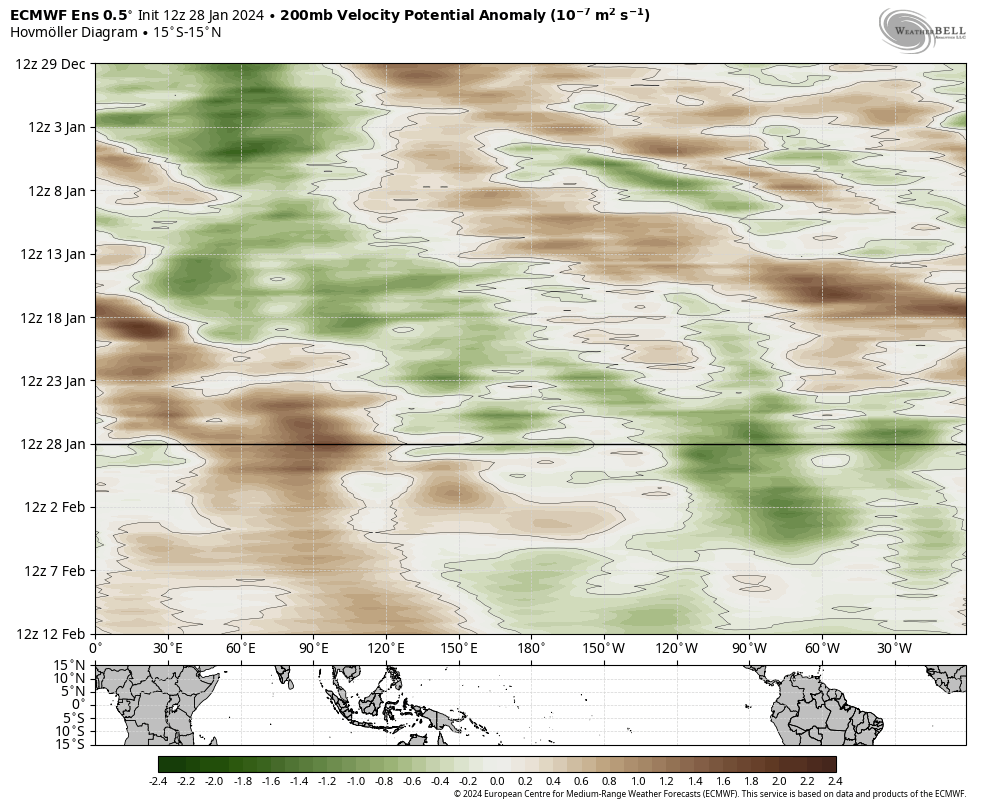
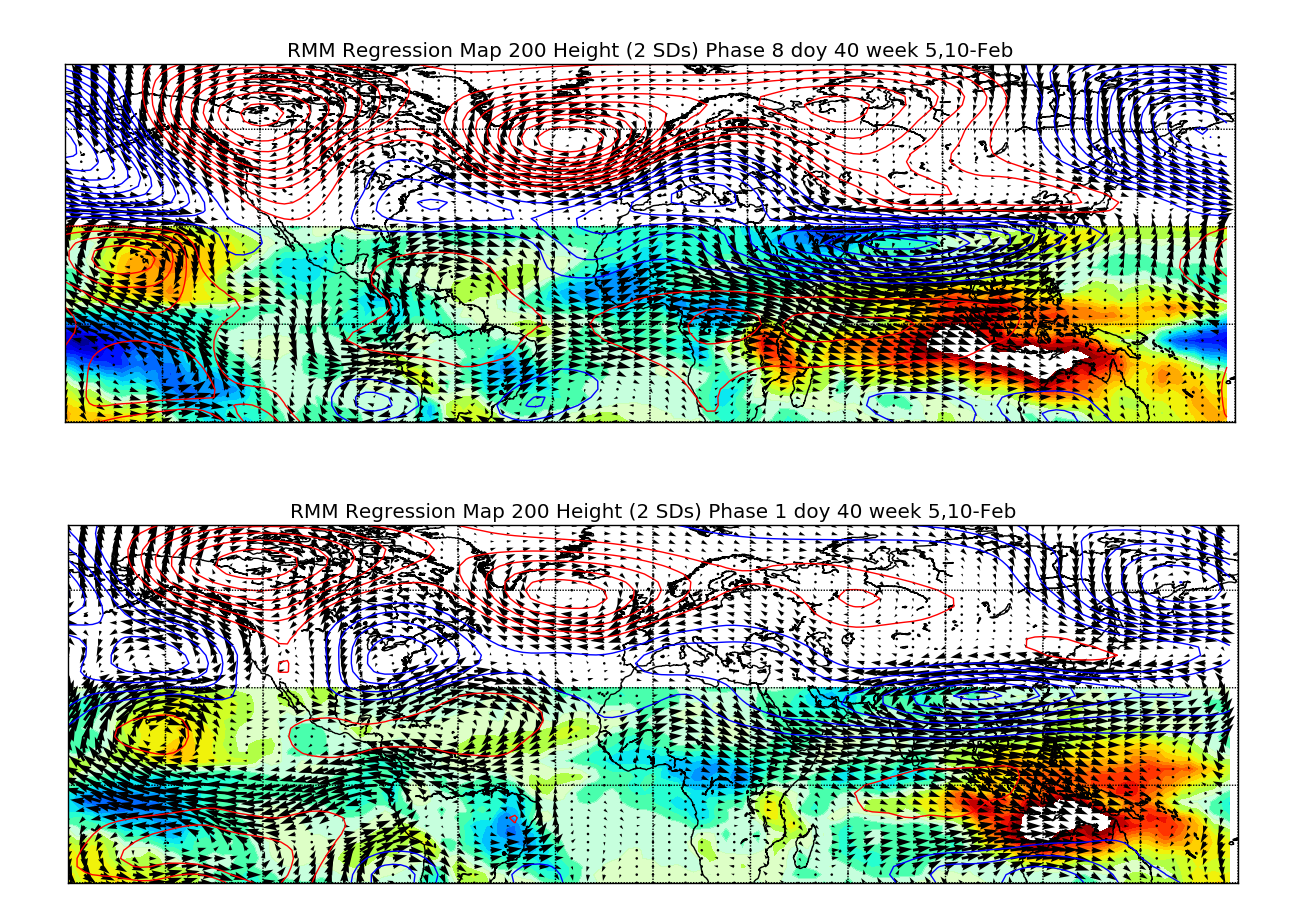
After a very busy few weeks (personally and professionally), I myself enjoyed knowing all week this week that there wasn't a legitimate snow chance for me to look at for the foreseeable future. I love snow but I needed to catch up . A warm-up after the recent cold snap always seemed likely. The warm-up probably came a few days later than I initially thought and is definitely lasting 1-2 weeks longer than I may have hoped. However, I still think we'll get another decent window of colder weather, likely starting around the middle of February. I do think this upcoming window may favor the eastern U.S. for snow more than parts of the Midwest. Tropical forcing has been relatively active and important this season, despite the strong El Nino. Note how passages through the western hemisphere in early-mid November and mid-late December were followed by pattern changes a couple of weeks later. The most recent wave has been especially amplified and slow-moving across the eastern Indian Ocean and western Pacific. This almost certainly contributed to the ongoing milder pattern not just being a quick deal. My guess would be that the combination of the collapsed +Indian Ocean Dipole event (that peaked in the fall), weakening El Nino, and ongoing stratospheric warming event earlier this month all contributed to such amplified tropical forcing in these areas. The pattern over the last week and over the next several days definitely has some resemblance to the MJO 5-6-7 composites for mid-late January. The question is, do we get continued propagation through phases 7-8-1? The dynamical models are a mess, the statistical models say yes: The dynamic models (EPS and CFS the last two images) suggest a very odd/confused signal over the next 10 or so days, followed by what could be a more coherent eastward propagation towards mid-February. The statistical models have a more consistent eastward propagation over the next two weeks. Looking at the actual velocity potential anomaly forecasts from the CFS and EPS: They suggest continued propagation through the first week of February, with forcing persisting thereafter over the western hemisphere. I would consider tropical forcing to generally be supportive of a transition back to a colder pattern, as it seems like one way or another, most guidance suggests we should see it become more focused over the western hemisphere in February. That supports a +PNA/-NAO. However, I would also consider tropical forcing to be a source of uncertainty as the models seem to be trying to sort out a complex evolution over the next couple of weeks. If we can get the phase 8-1 response the mild weather would not last forever: I would say the recent and ongoing positive East Asian Mountain Torque isn't necessarily the cause of the ongoing +EPO (I believe the tropical forcing is the cause), but the increased storminess the extended Pacific jet has caused is flooding Pacific air into the northern US and Canada. As the east Asian Mountain torque turns negative over the next week the PNA will briefly trend more negative. However, by mid-February the East Asian Mountain Torque is shown to trend more positive, so any -PNA trend won't last long. With more favorable tropical forcing that should increase blocking along the west coast and into Alaska: To me, it seems like there's a decent shot that by mid-February we see a more positive PNA and eventually more negative NAO due to the evolution of the mountain torque and tropical forcing. At the same time, our recent SSW event would be due to down well into the troposphere during the second half of February. So if we will see a prolonged period of tropospheric blocking it would begin during the second half of February. In short, more cold weather should be coming mid to late February. The pattern may end up being more favorable for the East Coast than Midwest overall, but there should be a period of relatively increased snow potential after the ongoing slow stretch.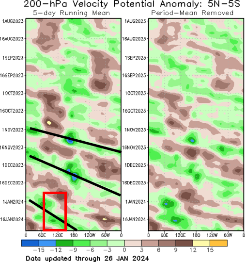
.png.e835bfbc48d65a58e193fc3bdcd4b140.png)

.thumb.png.f7ca9276972b388b97d47c5df3a4bb62.png)

.thumb.gif.f1e8c124ea8dec5e1acdd0b81972a5ec.gif)
-
Any chance you were out and about this morning there? I was also worried in the evening when I saw the warm surface temps, but I saw a lot of schools closed and I saw some reports of very icy conditions. Curious to hear how bad it actually was or wasn’t. TOL never got below 34 degrees
-
Went for a hike in the Novelty and Punderson areas this afternoon and drove 422 into Solon around 6 PM. Decent LES out there. Could definitely tell Novelty had gotten a few inches of very fluffy snow today and it was still coming down, especially when I left. The conditions coming into Solon when the LES band was more consolidated were solid, with visibility reduced to about half a mile as dendrites dumped. Snow rates may have been close to an inch an hour, the highway and main roads in Solon were snow packed with a good inch, and side roads and parking lots that were less disturbed looked to have a good couple inches on them. Back in Macedonia, I picked up slightly over an inch today...giving me a total of 13.7" over the last two days. It hasn't snowed many times this winter but when it has, it has delivered here.
-
I’ve been up in the Mayfield/Highland Hts area this afternoon and there have been some decent bursts of fluffy lake effect. The scraps overnight at my house brought my storm total up to 12.5”. Much of the area caught up yesterday afternoon through early this morning (although ironically, outside of Erie and Huron which didn’t verify, the warnings I’m least confident in being able to verify are Lake, Geauga, and Ashtabula lakeshore. The Ashtabula lakeshore zone is often hard to verify, but not verifying Geauga in this sort of setup while verifying the entire Cleveland metro would be quite a twist)
-
I will take a better look and respond to this over the next couple of days! I have some thoughts but would like to look a bit more/think a bit more on it. CLE hasn't had a snowier than average winter since 2013-14 (though most other sites have had at least 1-2 since), so whatever the cause it hasn't been a trivial stretch of poor winters from a snow perspective.
-
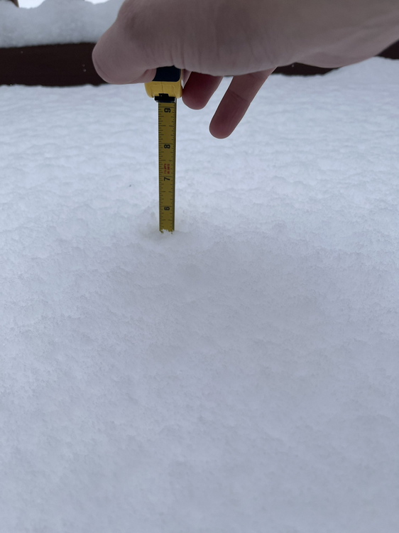
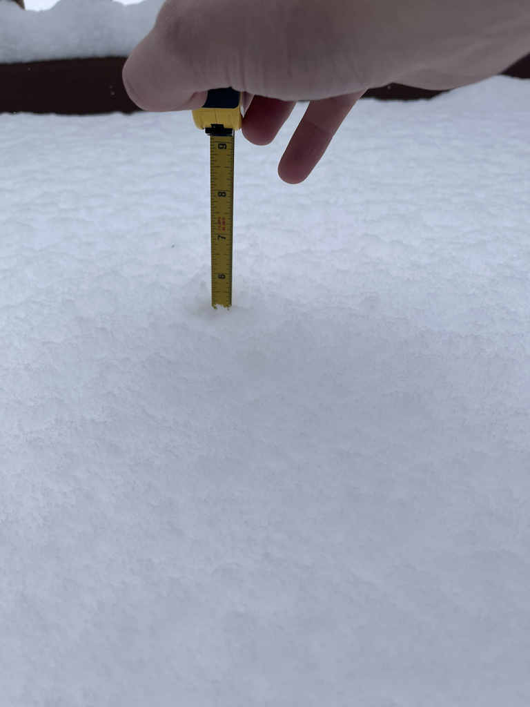
I'll do a measure and clear in an hour or so, but just sticking a ruler into my new snow since 1:20 brings my storm total to right at a foot! What an afternoon. Snow has finally slowed down, but hasn't stopped. Also, woof: https://x.com/Shinutsurai1/status/1748454511679582364?s=20 (17" public report from Maple Heights)
-
I was going to try to put something together over the next few days or week. Have fallen slightly out of touch with the long range on night shifts and with the incoming snow the last several days. A warm up after this cold snap isn't surprising to me, but I'll admit the long range ensembles are not giving me optimism regarding how quickly cold may come back after the warmup. I remember one event on super bowl Sunday in 2022 with this type of flow when a mesolow formed just east of the Islands and brought several (unforecasted) inches of snow to Erie/Huron Counties. This event gave me some flashbacks to that, but it didn't materialize at all. In that event the lake was mostly frozen but water opened up east of the Islands, whereas this one maybe it's the other way around with more ice there and more open water farther east.
-
You may end up grinding out accumulations through tomorrow evening so hopefully you catch up some, but agree the band is wiggling back west at the moment. Where it pivots this afternoon totals will be huge. I have 5.2" new since my 1.4" morning measure and it's dumping again here. The band will probably wiggle west until 3 or 4pm and then snap east after that as the trough axis moves through.
-
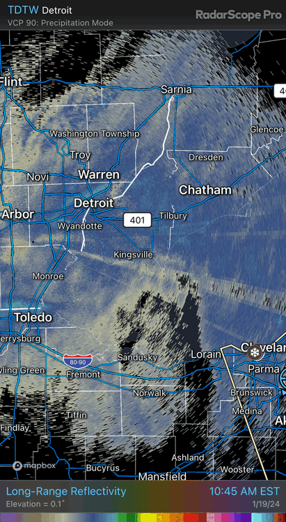
When the better lake enhancement started developing in Lorain Co early this morning the writing was unfortunately on the wall for the Erie and Huron warnings. The synoptic snow being even more boring than hoped hurt even more. With all of that said, there’s an interesting area of enhancement along a trough axis (with some Lake Huron connection) swinging southeast out of MI right now, so you may be able to add some more when it swings through later this afternoon. Not enough to get you close to 6” but maybe another inch or two wherever it goes. This event has been painful outside of the lake enhanced band.
-
Did Someone Say Clipper(Hybrid)!?! 1/18-1/19
OHweather replied to Frog Town's topic in Lakes/Ohio Valley
Same here with the lake stuff vs the synoptic. The synoptic at least produced a widespread accumulation but was largely hot garbage. QPF trended down the last couple of model runs and the ratios were more pedestrian. The lake enhanced stuff is high ratio and fairly intense. -
This lake enhanced band is quality...night and day compared to the widespread synoptic stuff. Just stuck the ruler in (didn't do a formal measure and clear) and have about 2.5" new since 8:30 (storm total nearing 4") and it is dumping dendrites under the band at the moment. Hopefully it persists through the late afternoon and swings around enough to give everyone a nice boost. Edit: 7" LSR from near Lakewood where the lake enhancement was more persistent this morning.
-
The Google search is concerning because I could see a lot of people doing something like that. A lot of the default phone apps use AccuWx or TWC as their "data" (I'm sure there are some others though)...which is better than Google at least, but still iffy. Snow has picked up somewhat in Macedonia where I am...probably close to an inch new since I measured. Hopefully we're looking at a nice, snowy next several hours around here to make up for the lack-luster synoptic snow.
-
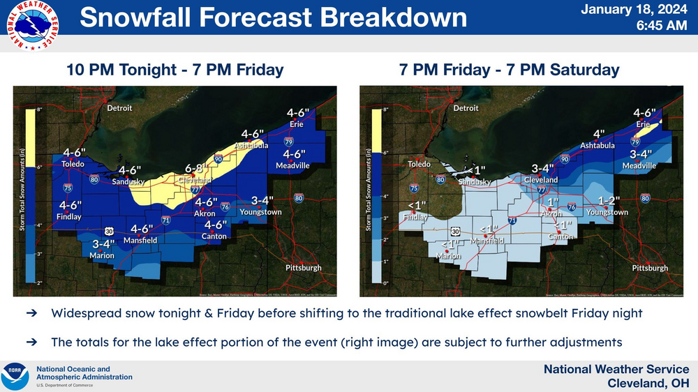
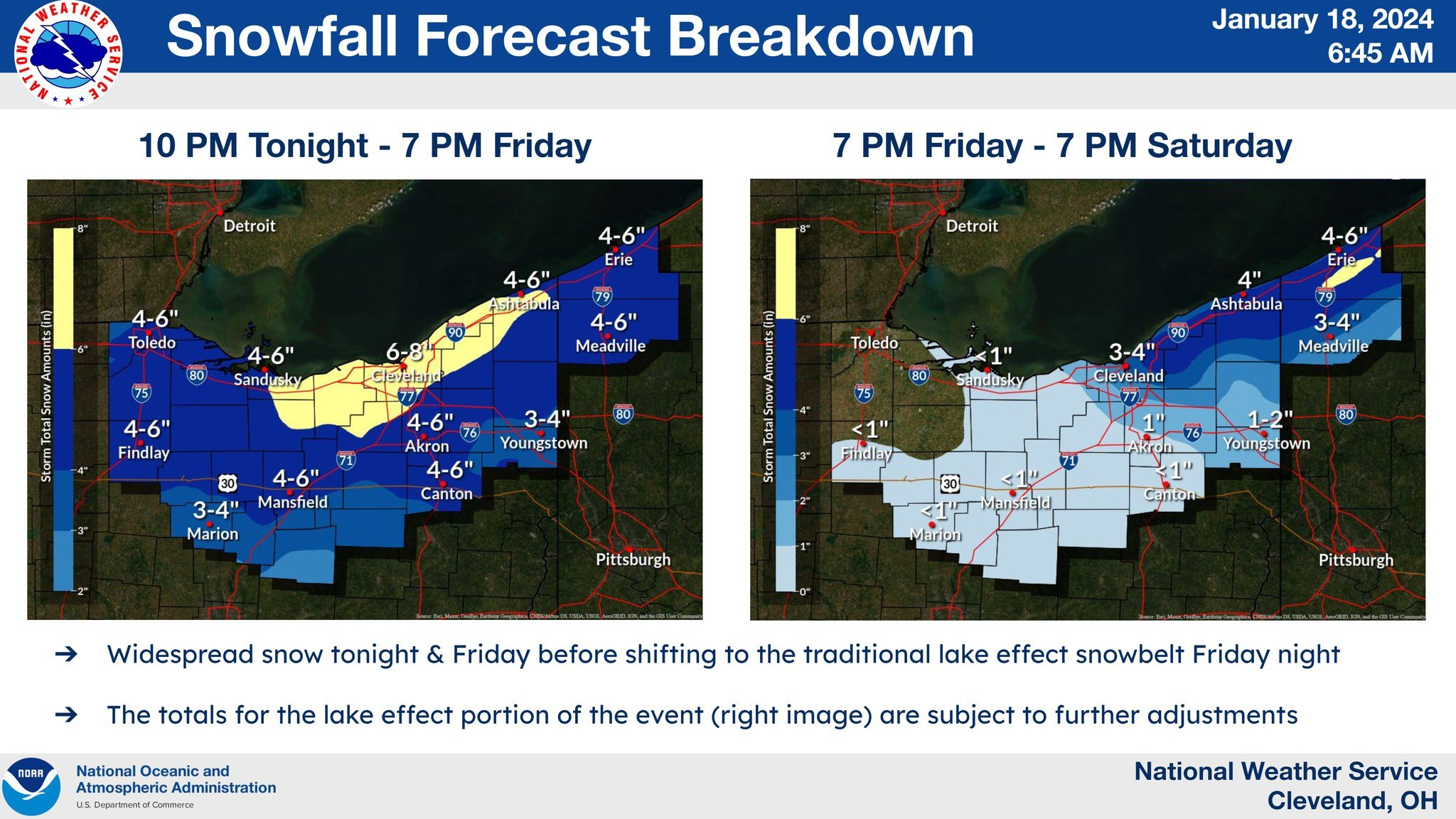
I agree with many of your points here...yes, that short burst of heavy snow last Friday heading into the evening rush was impactful and I would agree that peak rates (if they last any amount of time) are more important to the impact than the final storm total at the end of it. As for the weather app only showing 50/50 precip chances...I don't know what to tell you. I don't know who the provider is or how they come up with their forecasts. Seeing as though it's currently snowing everywhere it is garbage. I can see how 5-10" of snow on 50/50 chances for snow is confusing but the app appears to be bad. I usually advise people to pick a couple sources for weather information and stick to them..."shopping around" just gets confusing. I would suggest checking the NWS webpage (weather.gov/cle/winter) and social media (if you're on it) as those forecasts are what drive the watches/warnings/advisories...and we're certainly not perfect, but you're not going to get something there that's completely out of left field. You'll also be able to see the gridded snowfall forecast for the whole area, so you don't have to guess. There's collaboration that occurs shift to shift, between offices, and with the Weather Prediction Center (WPC) on things like QPF and snow so it's hard for a forecast that's entirely unreasonable to come out. And to be honest, I don't think our TV mets are bad in general, especially if you find a channel or met you like. I didn't catch all of them yesterday but I didn't see anyone hyping any crazy snow amounts, especially in Summit. I think people tend to run with the worst number they hear...and I do think it's a struggle to message storms like this where it won't be a heavy snow amount outside of the lake enhancement...and where the snow won't all fall at once. We never had 10" amounts listed in Summit County's warning, although if you told me that the warning probably doesn't apply to the southern half of the county I'd agree. We do attempt to keep these messaging/perception things in mind. This was posted to the NWS social media yesterday morning and emailed out to "core partners": It's not going to be perfect. The synoptic snow has trended down a good 1-2" farther south and west (and I hate that amounts in NW OH of 4-4.5" trigger the 4-6" range for the cities because they're realistically going to get 2-3"). But it also gets across that most areas are not getting 6"+ of snow in any 24 hour period, which was why we broke it down like that and sent it out. The areas that were forecast to get 6"+ in either window were where I did warnings yesterday morning (we no longer have a time constraint for warning criteria...just needs to be 6" for an event...but still wanted to draw a line somewhere). The big error here was the synoptic snow trending down 1-2", and the Erie/Huron warnings are probably not going to pan out. They have had some lake enhancement this morning but the best enhancement has already set up to the east and amounts so far out there appear to be 1-3". As for us farther east, the best lake enhancement is definitely working east now and guidance suggests it will pivot for a good few hours through mid-afternoon over parts of Lorain, Medina, and perhaps northern/western Summit before pushing farther east and transitioning to more traditional lake effect tonight. We still have a chance to pick up a decent amount of snow in parts of Summit through this afternoon.
-
1.4" new here so far. The synoptic snow was never going to be that exciting but it's going to end up being a general 1-3 instead of 2-5 across northern OH. Hopkins reported 1" of new snow last hour so the enhancement is working out...just need it to swing east, which is expected.
-
But is 4-6" of snow falling in a 36 hour period in Stow, which is what the forecast is, actually hyping it up big time? Can't control that all the schools are closing but the forecast is not for anything your area hasn't seen before. It'll be decent farther north where there's more lake enhancement.
.thumb.jpg.806f426f4131c8a190b571d556c090e6.jpg)
-
I see it barely flaked before about 8am but is snowing half decently now. Hopefully, most or all stayed open today but close tomorrow (which is probably the correct answer in this situation) Hopefully the typical "OHweather reduction" doesn't come into play since we did all the headlines this morning That was my last shift of the stretch so I get to just watch it play out and enjoy the snow. Have a feeling that the abundant synoptic moisture and good ratios will lead to this performing well, hence the somewhat aggressive forecast, but always get slightly nervous when model QPF is somewhat modest and we need ratios to get the totals to pan out. It can work though. The lake effect will linger all the way through Saturday in the primary snowbelt...likely won't be heavy by then outside of the Lake Huron band (which will be farther east) but it will snow for a long time.
-
Let’s talk winter!! Ohio and surrounding states!!
OHweather replied to Steve's topic in Lakes/Ohio Valley
On Friday the general consensus was that the low would bottom out around 975mb Saturday morning. It ended up getting to about 980mb. So it was a bit weaker than expected, and the gradient winds on the backside were slightly weaker as a result..the High Wind Warning verified in spots, but the southern row or so of counties in the warning fell a few mph short. -
The setup tonight into tomorrow is odd...narrow band of snow, the lift isn't that strong, but it looks like it'll be a very fluffy / high-ratio snow so it'll stack easily...plus it will be falling onto cold roads. I'm not that impressed through about 7am, seems like any accumulations by than are on the order of half an inch to an inch in Toledo. Lift does get a bit stronger starting right around 7-8am, so I could see spots getting another couple inches the rest of the morning. It should become much lighter during the afternoon. I realistically think the Toledo area gets 1-3" but with the heaviest occurring between like 8am and Noon. Someone could get a fluffy 4" but most will be less and feel like 3-4" amounts would be more likely into MI. There will be a sharp southern cut-off, so there's some chance it stays a bit farther north, though a total whiff seems pretty unlikely. I I think Friday morning is a little more clear cut, it'll snow 2-4 or 3-5" everywhere out there with peak rates between 3-9am (give or take).


.png.bd9a1e1e8afc3eb2996cd7ffdc7d0a8f.png)
.gif.6a05994d79994f93c6a40d786509b3f8.gif)

.jpg.9569ae93621ddb8095f7146dccdedb80.jpg)