OHweather
-
Posts
5,046 -
Joined
-
Last visited
Content Type
Profiles
Blogs
Forums
American Weather
Media Demo
Store
Gallery
Everything posted by OHweather
-
A bit over 2” here last night into this morning. Still seeing some off and on snow showers, but as expected the Huron band is well to my east. Maybe can squeak out another inch.
-
Feeling optimistic that we’ll at least need some advisories where the Lake Huron band sets up late Friday night and Saturday. The clipper still isn’t that impressive, but should bring light snow to much of northern Ohio on Friday at least.
-
Little clipper may graze us on Friday (though it seems like the swath of snow is targeting areas west/southwest of the Cleveland area the most), with some lake effect/enhanced snow Friday evening/night as the flow comes around to the north, with lingering lake effect in a north-northwest flow into the weekend. This doesn't look like a huge set-up, but probably will yield at least some light accumulations in areas impacted by the clipper and/or anything off the lake.
-
The idea of snow showers/squalls with the Arctic front was advertised decently well, but the localized amounts were predicted quite poorly, and the lack of a snow squall warning as that crap came in (which we can now issue without the burden of everyone’s wireless emergency alerts blowing up) probably didn’t help for anyone out and about. Luckily it didn’t happen 3-4 hours earlier. As it was, this “sub advisory” event in the Cleveland metro (between the squalls last evening and black ice this morning) was probably more impactful than about half of all winter weather advisory events actually are and was definitely way more impactful than the first LES Warning for Cuyahoga last week, and was more impactful than the LES warning for the inland portion of Ashtabula today.
-
Ended up with 6.5-7” here. Hopefully we have several more events like this on the way this season.
-
Your area looks to be doing quite well! It’ll be a mixed bag for this event, those near the lake haven’t gotten much snow but the inland Snowbelt is. I’m at work so won’t have an evening measurement, but I’m guessing my additional snow today and tonight will add at least a few inches for me. Not too bad!
-
Had a little over 3” this morning. After a few hours of not much happening snow is starting to pick up a bit again.
-
This is the first notable snow of the season for a lot of the area and it will blow around a good bit...but I agree the hype is likely a bit overblown due to the big dump over the weekend to the northeast. With that said, I think you'll still get several inches of snow by the time it winds down early Friday AM and it'll blow around a good bit. Up the lakeshore where there's a deeper snowpack and where they'll get much more wind this will be a big deal...the upgrade to a Blizzard Warning for Erie PA was not done likely, and I was close on (and slightly regret not pulling the trigger) Ashtabula and Crawford PA. Yeah, I could see how snow totals somewhat disappoint (we'll all get snow and it'll blow around, don't get me wrong) given the strong winds, though they do back off a bit Thursday afternoon and evening. The wind direction will be in the 290ish range a lot of Thursday and Thursday night, maybe briefly 300 or so. There are hints by several models of broad convergence in the Cleveland area points east-southeast, which could help focus snow through most of Thursday. That would be good for your area (and probably mine too), so fingers crossed. Truth be told it was somewhat marginal to issue, but once it hit Findlay and they gusted to 56 MPH with 1/4 mile visibility (and cameras on I-75 looked fairly decent), we went with it. Had quite a few reports of thundersnow, though I personally didn't see any. The Snow Squall Warning was the first ever for your area, and was only the second one ever issued by our office.
-
Interesting system incoming. It will be nice to get snow a lot farther inland with this event! Outside of a Lake Huron connection into NW PA I am skeptical of huggggge totals, but with the wind, falling temps, and occasional squalls it will be quite wintry for a larger area. I do not see how we avoid an all-out blizzard in Erie County PA tomorrow.
-
Unfortunately you may be correct here. Will be curious to see the morning snowfall reports. Snow finally pushed south overnight but activity weakened significantly just as quickly as it did that. Some signs now that it's trying to re-flare a bit, but it may also be trying to shift back north. I FINALLY have a forecast shift for this storm today and will have some annoying decisions to make with the Cuyahoga warning. Honestly all the OH warnings may be an annoying predicament by the end of the day shift (will need to try to figure out if it's worth keeping the warnings going for "impact" with some additional snow continuing through at least early tomorrow, or if it's better to downgrade to signal the worst is over if no one is getting more than another 4" tonight into tomorrow).
-
I think your area has a decent shot tonight through early Tuesday to get some snow, but the big winners will be around Lake County today. Already 13.9” of new snow in North Madison as of 9:15 AM!
-
Band is already ripping. Unfortunately, the American models have inched north. The focus for the crazy amounts will probably be northern Ashtabula into Erie and NW Crawford PA. Lake and northern Geauga will see accumulating snow at times (especially eastern Lake and northeastern Geauga), though after the rest of tonight those areas will probably largely be outside of the dominant mega band. I fully believe 3-4 foot totals are within reach in Ashtabula, Erie, and parts of Chautauqua Counties through Saturday.
-
It's nuanced and hard to say one model is definitively better...some certainly have their strengths and weaknesses. Out of the higher-res models available out there, here are some of my thoughts on them: The 3km/hi-res NAM is one of the better performing models for overall evolution of an event and amounts, though sometimes does not focus a single band enough (so has snow over too broad of an area with peak amounts that aren't high enough). The 3km NAM does have a bias to place bands a bit too far south in a westerly type flow The HRRR is better with nailing peak amounts in organized bands, though sometimes struggles to show enough snow when the fetch is shorter (struggles to depict weaker bands and upslope for whatever reason). The HRRR is better with single banded events like this. Like the NAM the HRRR has a habit of placing bands too far south with a longer fetch/westerly flow, and that bias seems to be worse in the longer term of the HRRR (more than 6-12 hours out) The ARW isn't too shabby either for lake effect, I've noticed it has a mix of strengths and weaknesses that the NAM/HRRR have. The ARW may be the worst in terms of placing bands a little too far south in this type of flow The RGEM/regional Canadian is better at keeping bands closer to the lakeshore with these types of events (long fetch with strong shoreline convergence), though sometimes places bands a little TOO far north. The RGEM looses skill once winds go more northwesterly. Overall, I've found that in events like this the band ends up somewhere between where the NAM/HRRR/ARW have it and where the RGEM has it, perhaps slightly closer to the RGEM a lot of the time. The global models (i.e. GFS, ECMWF, CMC) are best used to get an idea of the synoptic environment more so than actual snow amounts and placement.
-
It seems like there are two windows of WNW flow...Sunday/Sunday night into Monday (maybe an 18-24 hour window), a brief period where winds back more W or WSW ahead of the next shortwave later Monday, and then another good period of WNW flow later Monday night or early Tuesday through at least Tuesday evening. The environment for the first window will feature moderate and fairly deep instability with decent synoptic moisture and almost certainly an upstream connection to Lake Michigan...the second window appears to feature even stronger and deeper instability as we get a slightly deeper push of Arctic air behind the shortwave that goes by late Monday or Monday night. It's a little hard to pin down amounts this far out (need to see what the exact wind direction is, how consolidated/stationary the band will/won't be, etc.) but my impression is that both windows should support warning snow in the northern/eastern Cuyahoga into Geauga area. The second window may be a better opportunity for crazy amounts of over a foot, though parameters are pretty good Sunday into Monday too so if any band is consolidated enough and isn't drifting around too much someone could get a foot in that window too.
-
I full expect someone to have 3 or more feet by Saturday out that way, but I kind of think the band focuses a bit farther north than that, from far northern Ashtabula into Erie County. It’s a nutty setup and the model outputs are about as robust as I can remember around here.
-
Unfortunately we are all of nothing for headlines in every county (except Ashtabula and Erie which have the lakeshore zones). Our current forecast supports a warning just because we have a solid 6-12” along and north of route 6. If we get reports from 3 separate locations that average out to 6”+ in a focused period of time (used to be a strict 12 hour rule) it’s considered an LES warning event. So for instance, if we get a report of 12” in Montville, 7” in Hambden 4” in Chardon it verifies as a warning event for Geauga. We had a discussion at shift change when I came in late in the afternoon yesterday and I was a no vote on adding Geauga to the watch. We'll see how it ends up verifying (even if the northern part of the county does get warning snow into tomorrow, including the whole county in a watch for the whole weekend felt like overkill). That said, I do worry it focuses a bit farther northeast than our current forecast late tonight through early Saturday, which would leave pretty much all of Geauga and maybe even a decent chunk of Lake without much snow. This is a pristine LES setup, but the southern cutoff will be very sharp. Still looks good for stuff to shift farther inland by Sunday night or Monday.
-
Yeah, unfortunately we’ll watch the snow fly just to our north through most of the weekend. There could be an initial band that starts from the Cleveland metro into Geauga late tomorrow night into early Friday before it locks in closer to the lakeshore. While I think north east of us along I-90 will be the big winners, the environment is still pretty favorable for LES Sunday into the beginning of next week when we should get a more WNW wind direction. I’d say better than 50/50 odds we get a WNW flow band from Cuyahoga into Geauga at some point in there that drops warning criteria snow.
-
Measured about 2.3” here before I went to bed, already about half melted. A nice event for some with an interesting looking pattern starting next weekend.
-
What an overperformer in the Cleveland metro and east side!
-
It wouldn’t stun me if someone near Mayfield gets half a foot of snow in the next few hours with the band looking like it’s going to pivot there as the winds shift northwesterly.
-
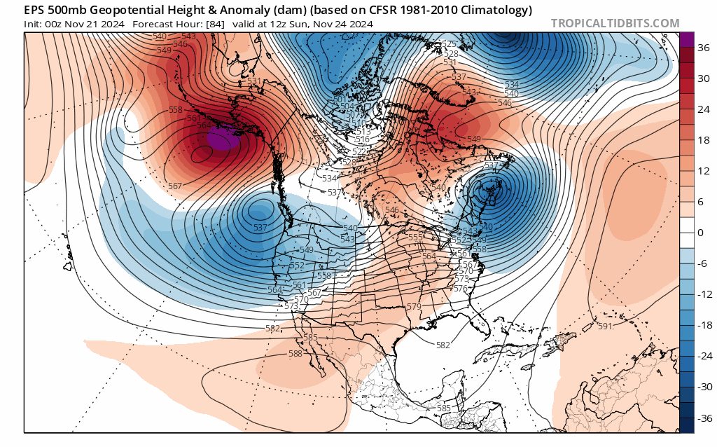
Well I'd roll these dice if this pattern evolution is close to correct. It would be reasonably cold with snow opportunities for most of the sub-forum from late next week through probably the first 10-15 days of December. The pattern looks panhandle hook/cutter-ish initially the end of November and looks more clipper-ish by a week into December.
-
Let’s talk winter!! Ohio and surrounding states!! 24'-25'
OHweather replied to buckeye's topic in Lakes/Ohio Valley
I've been gradually working on it. Hopefully can get something posted later this weekend or next week. We'll have some chances around here, but I don't expect a wall-to-wall great winter. Probably will be a couple decent cold windows with snow chances with a couple of prolonged mild spells as well. -
Passing the time at 4 AM is an art The lake effect that pushes into the metro area and east side late this afternoon into this evening will probably be intense, and it should be cold enough for it to snow and accumulate away from the immediate lakeshore (it'll likely snow down to the lakeshore but may not stick). It'll probably push through the area within like a 6-8 hour span, but if a band can hang over any particular spots for a length of time a quick few inches is possible. Most will see less, but I will take this potential all things considered
-
About an hour and 15 mins lol. The crazy solutions have backed off, but it's looking like there should be snow flying Thursday into Thursday night as moisture wraps back in from the north/northwest. Maybe parts of Ohio can see a light accumulation. It's nice to have a little bit of snow to look at, even if there's still nothing extremely exciting on the horizon.
-
Let’s talk winter!! Ohio and surrounding states!! 24'-25'
OHweather replied to buckeye's topic in Lakes/Ohio Valley
Nothing too exciting on the horizon, but most of Ohio should see at least a few flakes in the air Thursday into early Friday and a few spots may see a light/slushy accumulation. Just enough to remind us that we're deep into November already.