OHweather
-
Posts
5,046 -
Joined
-
Last visited
Content Type
Profiles
Blogs
Forums
American Weather
Media Demo
Store
Gallery
Everything posted by OHweather
-
Nice over-performer underway. Pretty much no issues with the marginal temps whatsoever! It came in quick and started sticking immediately, and should hold at or below freezing all afternoon with this steady snow. Already a tad over 3" here.
-
Cute little system tomorrow into tomorrow night...it's progressive, but there is respectable jet support and moisture to work with, and lapse rates in and above the DGZ may support some slantwise convection for a few hours in the afternoon. Basically, the synoptic snow won't last too long and it will be on either side of freezing, but there could be a period of 0.5-1" per hour rates and large flakes that roughly comes up along or just southeast of the I-71 corridor beginning late morning in southern OH and getting into northeast OH in the afternoon. There's a period late Sunday night into Monday morning where lingering synoptic moisture and "cool" northwest flow may allow for some lake enhancement to flare-up in the higher terrain southeast of the lake. I'm guessing it's a general 1-3" with the synoptic snow...maybe a localized 4" lollipop if heavier rates impact the higher terrain where it'll accumulate best...followed by a coating to 2" of lake enhancement/upslope in the favored areas. I'm actually kind of looking forward to it! Though, that's more of a product of me liking snow and not getting much of it this winter.
-
Winter 2022/23 Short/Medium Range Discussion
OHweather replied to Chicago Storm's topic in Lakes/Ohio Valley
I suspect when advisories go away we'll see a bit more of a shift towards the "impact-based" paradigm, as when we only have the warning headline we may have to issue warnings when we think an event will be high impact, regardless of if it hits criteria. I'm curious to see if what becomes of advisories (the broad "plain language statements") are issued more like today's special weather statement, a soft headline that technically isn't a watch/warning product, which may also allow for more impact-based considerations. I've never loved having a set snow criteria for advisories, because as you said there are many other variables that can make a given amount of snow higher or lower impact. Am hoping for more synoptic winter storms to test out the tweaked WSSI this winter...this isn't a bad look if it's correct: I think the western ridge is legit, but we'll see if we get that subtle little -NAO that can help push the PV south over Hudson Bay, which would get all of the subforum cold enough for snow in late January.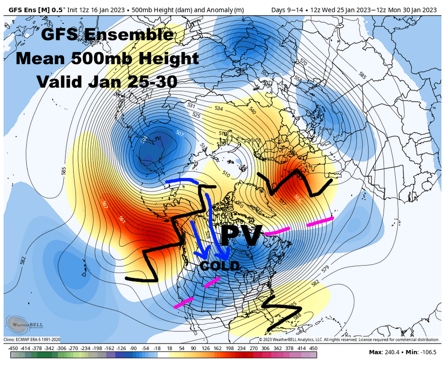

-
Winter 2022/23 Short/Medium Range Discussion
OHweather replied to Chicago Storm's topic in Lakes/Ohio Valley
Sure. I believe the agency as a whole is pushing to highlight the impacts of winter weather more...you see this with the recent emphasis on snow squalls, with products such as WSSI that give impacts for more than just total snowfall, and in training I recently went through regarding winter weather stuff I got the impression that they wanted impacts to be considered when issuing winter weather headlines. However, there are still a lot of different individual forecaster opinions along with varying philosophies from office to office. I can say from a verification standpoint, warnings are verified based on what gets put into Stormdata. Basically, warning level events or events resulting in fatalities are supposed to be entered. So if there's no warning out covering an event entered, the event was missed. If there is a warning out and no event gets entered into Stormdata, the warning is a false alarm. It makes it very hard for offices to "massage" the numbers (I don't necessarily mean cook the books so much as leaning a certain way if it's "close" based on what headlines were out...basically, less room to give yourself a buffer, which I don't think is the best when verifying a forecast). Some offices (including mine) are big on consistent Stormdata entries. If similar events have been written into Stormdata before they should continue to be entered...and vice versa if similar events haven't traditionally made Stormdata. We have a clause here that winter wx headlines can be issued based on impact, but when we verify it in Stormdata we need tangible evidence of "impact" from a given forecast zone...high standards to get included if amounts are sub-criteria...so, for us to go with the "impact based" headline (especially warnings...advisories can be a little looser) we need to be pretty sure that the aggravating factors will be significant. In the case of the December 23rd storm, at least in the CLE CWA, that was the case and everyone issued warnings. -
The consistent light snow through last evening added another 1.5" here, so ended up a bit over 2" for the storm. It was a snow-filled day even if it wasn't all that exciting.
-
Measured 0.7” before 8am…some light accums since, probably over an inch total. It’s modest, but looks nice on the trees. Very fine flakes occasionally mixing with a bit of freezing drizzle at the moment.
-
Such a garbage system lol. At this point the highest terrain upslope areas may get 2-4"...maybe 5" near Chardon. The Chautauqua ridge in eastern Erie Co and Chautauqua Co may be able to get a bit more, but this is very unexciting back towards Ohio.
-
Winter 2022/23 Medium/Long Range Discussion
OHweather replied to Chicago Storm's topic in Lakes/Ohio Valley
Yeah I suspect the SE ridge tries flexing at times into February given La Niña climo and also the MJO working through the Indian Ocean and western Pacific late this month into early Feb which also teleconnects to a SE ridge. So, the amount of blocking (especially over Alaska and western Canada) may say a lot about how much the gradient can be shoved south into the sub forum in the face of that. I do think there’s a window where we’re all pretty cold and the storm track shifts far enough south for most to be in the game around the end of this month, but we’ll see how long that can last. -
Winter 2022/23 Medium/Long Range Discussion
OHweather replied to Chicago Storm's topic in Lakes/Ohio Valley
I only post like 4 times a year gotta make it count -
Winter 2022/23 Medium/Long Range Discussion
OHweather replied to Chicago Storm's topic in Lakes/Ohio Valley
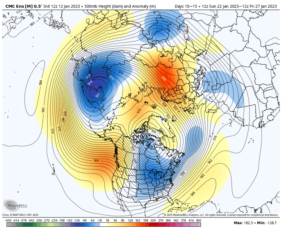
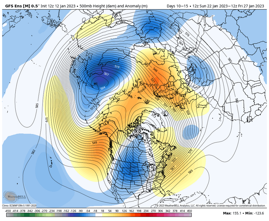
Getting much more encouraged about the upcoming stretch…all ensembles have a ridge bridge across the Arctic in the 10-15 day with cross polar flow into a deepening trough into the central US. Get this into the 6-10 and that’s a pretty high confidence significant cold signal for someone. There is disagreement over how far east the trough axis sets up, though I’d characterize this as an EPO cold shot and those often don’t make it into the eastern US as quickly as modeled so the GEFS may be a little more correct. Regardless of the exact evolution, the pattern will be turning much colder over most of the continent in late January and the gradient may setup somewhere across the sub. The GEFS could support a bigger cutter favoring the western sub, while the EPS and GEPS could support more of an Ohio Valley runner and clipper look. I feel confident we’ll have a legit period of wintry temperatures and increased snow potential the last week of January into the start of February, though still plenty of details (how cold, how much snow and where) to still sort out. From there, the question will be if we can maintain this favorable Pacific pattern with a ridge along the west coast into February or if we see things slide back west and allow the Southeast ridge to flex. We’ll also have to watch the stratospheric polar vortex for possible disruptions and the blocking on the above means near Scandinavia…both could lead to a more -NAO well down the road. So, lots of uncertainty the rest of the winter but we definitely have a window coming up…and we’ll go from there.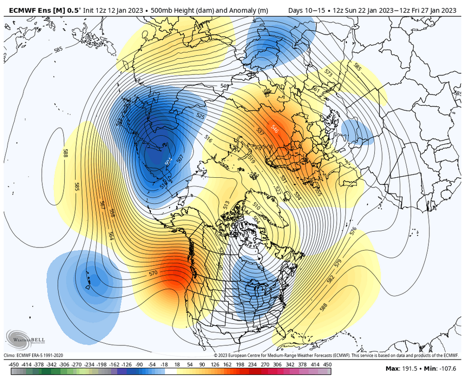
- 815 replies
-
- 10
-

-

-
I'm actually not extremely enamored with this setup...think we'll get a quick 1-3" of synoptic snow Thursday night in north-central and northeast OH. There's probably a lull of sorts early Friday between the synoptic snow and lake enhancement that will ramp up into the morning and continue through most of the day, with that activity ending Friday evening. The lake enhanced snow may be moderate for a time on Friday, especially in the hills and especially with some sort of Lake Huron connection coming into play with winds going NNW to nearly due N. Even during the lake enhancement, I think we're looking at persistent light to moderate snow, as the instability is marginal and the synoptic lift is modest...the hills/upslope will definitely help, but it'll be hard to get 1"+/hour rates out of this. With the snow rather spread out, a struggle to get heavy rates, marginal ratios and warm ground, I don't feel this will be that exciting. That said, it will snow for a while and in the hills upslope/lake enhancement will add a good amount of QPF. I actually could see us needing to up amounts a bit farther west in the hills of the secondary snowbelt...someone in northern Geauga as well as Erie Co PA could squeeze out 8" with the upslope, but it'd be over a 24-30 hour period and I think most will probably be more in the 3-6" type range in the inland primary snowbelt. Guessing we'll need some advisories tonight or early tomorrow for it...kind of hoping we don't try pushing the warning button unless things look more impressive. The "negativity" aside, it will snow and accumulate and should look nice on the trees. More sustained cold may arrive towards the end of January...or at the least, a return of more frequent transient cold shots between the 50 degree days.
-
Winter 2022/23 Medium/Long Range Discussion
OHweather replied to Chicago Storm's topic in Lakes/Ohio Valley
My guess is we go to a gradient pattern towards mid February with cold dumping into the Rockies and upper Midwest with a Southeast ridge. I think the Aleutian ridge will hold on for at least a few weeks which will keep dumping cold into North America, but usually that retrogrades after a while and ends up being a -PNA. I think we all have a crack end of January into early February…thereafter, odds probably tilt towards farther north and west being favored. -
There were some nice bursts of borderline moderate snow last evening that quickly covered anything that wasn't paved, which was nice to see...even if the good snow lasted all of 20-30 minutes where I was! I'm getting a little more optimistic we get a crack at a better pattern for a couple of weeks around the end of Jan/beginning of Feb...but it's quite possible we don't get much of anything until then. Low odds we get a little wet snow with the low pressure going by this Friday if it tracks just right I guess, but I'm not optimistic. So, we'll see if that brief period around the end of this month can deliver. I'm sure we'll get some snow, but it's been scraps so far if you don't live up towards Erie or Buffalo (not that I'd want what Buffalo has had to go through this winter).
-
Occasional dustings of snow over the last 36 hours here that have struggled to stay on the ground for long during the daylight hours...running "event total" of 0.8" with less than 0.5" (so a T) on the ground at the moment. Racking it up this season.
-
Winter 2022/23 Medium/Long Range Discussion
OHweather replied to Chicago Storm's topic in Lakes/Ohio Valley
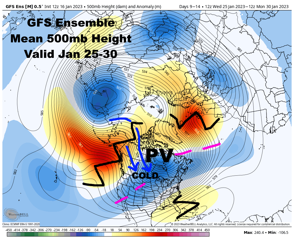
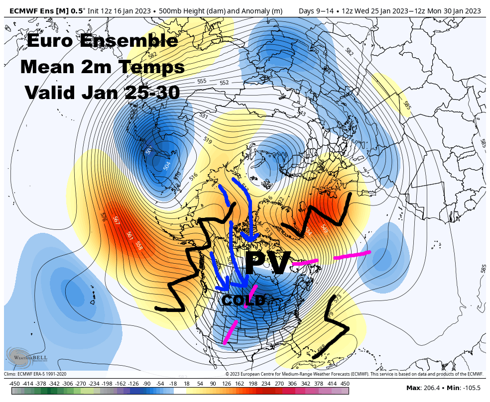
Kind of interesting to watch how the pattern has evolved from November 1 through early January. In general, for November and the first half of December, we had a north Pacific/Aleutian ridge that frequently resulted in a western US trough...a -PNA/fairly typical La Nina pattern, with what could be characterized as a relatively weak/retracted Pacific jet stream. Since then, we've switched to a strong north Pacific/Aleutian low, which is blasting the Pacific jet stream into the west coast and cutting off an Arctic influence into the CONUS. This can be characterized as a very strong and extended Pacific jet stream, more typical of an El Nino. While the Pacific has been the issue preventing sustained cold for much of the late fall/early winter, it's been because we've gone from one extreme to another, with only a brief period in between in mid-late December where we managed a more favorable pattern for widespread cold in the CONUS. We have had blocking at times...the Aleutian ridge flexed to the point where it was a -EPO that facilitated cross-polar flow at times in November and December (which is the typical way to get Arctic shots in a La Nina), and we had a relatively robust -NAO for most of December...but we've seen a mix of Pacific patterns that are different but mild for the central/eastern CONUS in their own ways and have torched when blocking relaxes. The Pacific jet stream will weaken considerably over the next week, finally, as much lower pressure over eastern Asia (a negative mountain torque, which requires a loss of westerly atmospheric momentum/a weakening of the jet stream to compensate) and a downturn in convection over the western Pacific warm pool (resulting in less latent heat release and a weakening of the gradient over the western Pacific, also weakening the Pacific jet) both suggest a quick loss of westerly momentum over the Pacific. This is why ensembles are hinting at the trough backing away from the west coast and allowing heights to rise at least somewhat after mid-January. My guess is we transition back to a more typical Nina pattern into February when tropical forcing returns to the western Pacific and enhances the lingering La Nina circulation, but with perhaps another one of our "brief windows" in between where we can get a ridge along the West Coast in a spot that can increase polar/arctic influence into the central and eastern CONUS for 1-2 weeks around the end of January/early February as we make that transition..gif.ca8ad0c3f21e39a6d3179dd295a3119d.gif)
.thumb.gif.b7ef85c3830021fff9b1d419a31f3031.gif)
-
Merry Christmas! The LES warnings for Lake and Ashtabula today may not quite have been needed as it lifted back over the lake pretty quickly into this morning, but still a white Christmas with plenty of snow on the ground. In Mentor for dinner and probably a couple more inches on the ground here compared to Reminderville but nothing too crazy.
-
Pre-Christmas (Dec 21-23rd) Winter Storm Part 2
OHweather replied to Chicago Storm's topic in Lakes/Ohio Valley
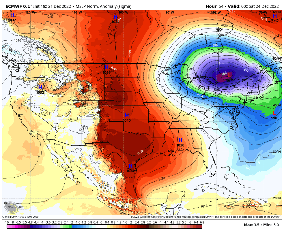
Only about 4” or so of snow here, but many sites in northern Ohio and northwestern PA, including both Cleveland airports and Erie, met official blizzard criteria today. Here’s CLE 5 minute obs: https://www.weather.gov/wrh/timeseries?site=KCLE Note the <0.25 mile stuff, solid blizzard conditions from 8am-3pm and briefly 6-7am. Port Clinton OH is even more impressive, look at those gusts over 60 with temperatures below 0! https://www.weather.gov/wrh/timeseries?site=KPCW Areas east of I-75 over towards Lorain OH are more open and had extensive issues with blowing snow, including a fatal pileup on the turnpike. -
Several sites easily verified blizzard conditions today, with visibility frequently below 1/4 of a mile and gusts well over 35mph…along with sub zero temperatures. Cleveland Hopkins, Burke Lakefront, Lorain County, Port Clinton, Lost Nation (Willoughby), Akron Canton, and Erie all hit it for 3 hours straight or longer. Findlay, Akron Fulton and Youngstown have strong arguments but didn’t quite get into the sub 1/4 mile stuff for 3 straight hours, so it’s more debatable. Mansfield, Wooster and Ashtabula also met conditions briefly, but weren’t really close to doing it for 3 hours. CLE verified a blizzard from 8am to 3pm! And briefly around 6-7am! https://www.weather.gov/wrh/timeseries?site=KCLE Not nearly as bad as what Buffalo is dealing with and not in the same league as 1978, but we can say we experienced a blizzard today which is uncommon around these parts. The cold and wind combination was unique. Estimating a bit over 4” of snow here, and we are still getting the occasional house shaking gust.
-
It took a while for everyone agreeing on upgrading to the blizzard warning but it seems to have been worth it for the conditions. It was and still is pretty brutal out there.
-
The warnings for that area said 2-4” and you’re gonna get the 2” instead of the 4”…this was never going to produce big snow totals in OH, although the I-71 corridor is looking to be the ones who get luckier in those regards as opposed to NW OH.
-
Definitely some noted trends for the post frontal snow to be a bit more robust tonight, even in central and southern Ohio. There isn’t a crazy ceiling here but even many of you folks getting a solid few inches down there seems more plausible now.
-
Definitely some snowier trends with the post-frontal burst later tonight into tomorrow morning for a good portion of central and eastern OH. Thinking the Cleveland area has a good 4-6” down by midday with whatever light wraparound comes after. Curious to see how my drive back down 480 goes at 8 or 9am assuming I choose to try it.
-
Pre-Christmas (Dec 21-23rd) Winter Storm Part 2
OHweather replied to Chicago Storm's topic in Lakes/Ohio Valley
I'm pretty worried about something similar playing out in parts of NW Ohio tomorrow through at least early Saturday, where they're getting 2-4/3-6" of snow with 50-60mph wind gusts for a very prolonged period. Just for the sake of picking your brain a bit, do you know if there was blowable snow already on the ground that made that worse? And I guess my other question, was the strongest wind with the heaviest snow, or did it occur afterwards? Because to me, the new snow amounts, wind and duration of it in NW Ohio (which, like northern IL outside of the Chicago area, is actually quite flat and open) seems at least as bad as what resulted in the impacts described in that entry, though the strongest winds probably start ramping up after the heaviest snow. I could see parts of NW Ohio being absolutely crippled tomorrow into the weekend though. -
Pre-Christmas (Dec 21-23rd) Winter Storm Part 2
OHweather replied to Chicago Storm's topic in Lakes/Ohio Valley
Euro trending a little more amped in recent runs I am really worried about the wind from parts of lower MI, IN, and OH into southern Ontario, northwestern PA and western/northern New York. You have a 5 standard deviation low followed by a 3.5 standard deviation high, very strong cold air advection, with flow funneling down the Great Lakes basin. Gusts could reach 60+ mph in a large portion of that corridor, with up to 75mph downwind of Lake Erie into the Buffalo and Rochester areas. Huge impacts in parts of that corridor, especially downwind of the lakes where lake enhancement will occur..thumb.gif.4763a0e27d080003bc86d1dbf2116a45.gif)

-
This is not the most exciting storm if you're simply going for big snow amounts/rates (though, rates will briefly rip pre-dawn Friday behind the front). I'm guessing public perception will be super mixed...people who have been hearing about a huge storm for days but stay inside on Friday will be underwhelmed when/if we only get a few inches of snow. But, those who hear we're only getting a few inches of snow and venture out on Friday will probably be caught off guard by how brutal the conditions are. Roads really will not be fun Friday through early Saturday with the flash freeze/quick snow accum early Friday followed by intermittent snow and extensive blowing/drifting snow. As for my expectations, I still think a 3-6" type snow (more up the eastern lakeshore from LES, but I'm also not optimistic in much of a lake boost into NE Ohio...maybe north of I-90 from Lake County points east gets some more help) with 50-60 MPH wind gusts and brutal wind chills (-20 to -30F seems quite likely Friday through early Saturday) is a lock. I think we all get a quick 1-3"/2-4" burst behind the Arctic front...it won't last long, but the upper dynamics are briefly very supportive early Friday before we dry slot. The GFS continually deepens the low a bit quicker and slows it down, giving us more wrap-around later Friday into Friday night, and would support probably a 6-10" type snow (the front, plus several more inches of wrap-around). My impression is it's overdone, but it's insistent and given how closed off/deep the trough aloft is, perhaps there's room for the system to intensify and slow down slightly quicker. The Euro is not THAT different than the GFS but deepens the low a bit slower and lifts it northeast slightly quicker, so we get less QPF with the wrap-around. However, the Euro still suggests deep saturation through the low and mid-levels through early Saturday and has mid-level warm air advection/isentropic lift late Friday into Friday night, as the low occludes and warm air aloft starts wrapping back in from the north, so I think the Euro would still bring some wrap-around snow...but, it's much less dramatic than the GFS. The GFS solution still casts doubt on the winds. All models suggest we have no problem mixing to about 850mb Friday afternoon into Friday night, and all models suggest at least 50 knots of flow at that level. So, I think 50-60 MPH gusts (lakeshore and NW Ohio more 60, interior NE Ohio more 50) are still likely across the board. The GFS (and the FV3 WRF) have 850mb winds of 60-70 knots in that window, and soundings from the GFS and FV3 suggest widespread 60mph gusts, even inland, with potential for 70+ right against the lake is possible. That's probably the difference between a typical amount of power outages and something more widespread. With how cold it is until early next week, more than isolated power outages could quickly become an issue with homes getting cold and potential damage to infrastructure. A general rule of thumb given the setup being quite favorable for strong winds is that the wind speed in knots at 850mb Friday afternoon through Saturday roughly correlates to surface gust potential in MPH (i.e. 60 knots at 850mb probably supports 60 mph gusts...the lakeshore may do even better). Still another day to watch trends. I've largely punted LES potential for most of us but do think there's room for trends with the wrap-around snow and what the peak wind gusts end up being, which still is the difference between an impressive/impactful storm and something more life-threatening. Will the GFS trend weaker/faster, or will other models trend stronger/slower? That's the question...


.gif.95d1cabc5751c96661117789a04d9174.gif)
.gif.bfa69bb02ffc7f8b00d0c09040ff9ced.gif)