OHweather
-
Posts
5,046 -
Joined
-
Last visited
Content Type
Profiles
Blogs
Forums
American Weather
Media Demo
Store
Gallery
Everything posted by OHweather
-
Fun drive. Was a little worried about how my Kia Stinger would do in real snow…surprisingly well even with all seasons on it. Guess having an AWD with the tech they put in these things nowadays helps, even if I start getting it sideways it whips me back into line pretty quick. Now to make the same drive at 5am after a night of continued snow.
-
Think areas that stayed all snow in north central and NE Ohio will overperform some. Seems like 4-8” so far where it’s stayed all snow and probably a good 5-9” more with snow lingering into early Friday now. Canton to Youngstown have seen no snow yet lol. Sharp cutoff down there though they should flip and get a few inches, with the current mix turning into a mess as it freezes tonight. Roads suck, wish me luck on my trek from Brooklyn Hts to Reminderville!
-
This is some lazy analysis using the HRRR, but check out the trends with the location and strength of the second wave 12z tomorrow...trending more amped. Precip shield edging a bit northwest as well. And, the high is backing off slightly in newer runs. May be a legit trend.

-
Starting to sleet a bit here. 0z NAM, hi-res NAM and HRRR really juiced and snow longer into tomorrow night. Could be the last-second amped trend we often see. As @TheClimateChanger mentioned the result would be a huge storm. Was worried my AFD on Monday was a little too hype-y talking about pushing snow removal infrastructure past it's limits if we stayed all snow and got 12-18" in the Cleveland area, but those models would bail me out. The 18z Euro trended a bit that way too with more snow into tomorrow night so perhaps the idea has some legs.
-
If you have radarscope, it has the terminal doppler from DTW. It's not the best but can help when DTX is down.
-
Anyways, overall trends have been for wave 1 to be a little more amped, resulting in NW Ohio seeing more of that QPF as rain today, and for wave 2 to be similar or slightly flatter. This should keep the Cleveland area just snow on Thursday, though Akron/Kent/Medina/Trumbull Co will probably find a way to sleet at times still when the WAA aloft really rips. It just always happens. There has also been a modest trend for the second wave tomorrow to be a bit slower. A few implications: 1) A little less overlap in the axes of heaviest snow with each wave in NW Ohio, leading to a more "ho-hum" 8-14" or so type event instead of the historic storm for Toledo that was on the table. Could still push top 10 2-day snows there (only needs to go over a foot for that). Even Cleveland loses a bit more QPF to rain, though they weren't slated to get as much from this first wave (and should still change to snow and get some accumulation this evening through tonight) 2) The flatter second wave should keep mixing well south of Cleveland, the lakeshore counties and snowbelt on Thursday, and will probably mainly be snow and some sleet in Akron. This brings the axis of heavier snow with the second wave a bit farther south. Still think Canton and Youngstown points south lose a fair amount of QPF to sleet or freezing rain through Thursday...however: 3) The somewhat slower trend with the second wave allows a little more QPF to fall into Thursday night, when the whole area will be cold enough for snow. So, this will help boost totals a bit more down towards Canton and Youngstown. Feel like a rather safe 8-12" is a decent call for NW Ohio, Cleveland and the lakeshore counties and Snowbelt. Can't rule out the second wave trending a bit more amped and overperforming but feel like any 12"+ amounts will be more the exception than the rule. With falling temps through the event and wind to blow the snow around roads will be bad from tonight through Thursday night. Akron I'd be more like 6-10" as I still think they lose a bit to sleet and lower ratios, but a good storm and a dense accumulation...roads won't be pleasant. Canton/Youngstown I'm thinking it's more of a 4-8" or 5-9" with more sleet and probably at least some freezing rain. Should easily warrant a warning, and I'm hoping the early 12z stuff coming in a bit snowier down there will help nudge the headline decision in that direction.
-
Was not in the office yesterday or today...but from what I gathered the reasoning for holding watches south/east of Cuyahoga and Lake was more time to refine the exact accumulation forecasts, start times, and collaboration with ILN and PBZ who wanted to hold watches outside of the "slam dunk" areas farther north and west where it will just be snow and start sooner. The goal is to issue warnings 12-24 hours out unless there's overwhelming confidence and it's a higher-end situation so they did have time to hold the watches another cycle yesterday. With that said, I will agree to disagree with our current advisories from Knox-Holmes-Stark-Mahoning.
-
Anecdotally, I don't trust this system not to mix all the way up to at least Akron, OH, which the Canadian/RGEM insist on. And maybe the Canadian models are doing better with the PV over Canada. That's my analysis for the day But for real, I think how the PV interacts with the storm is quite important here for wave 2. With a jet streak to the north providing plenty of divergence aloft and with the precip largely being driven by warm air advection processes...to go along with what should be a lot of latent heat release from convection in the Gulf Coast states and from the anomalously high PWATs getting wrung out as the moisture gets lifted over the front, I feel like if the PV doesn't press down more there is room for last second northwest bumps with the wave on Thursday. If the PV presses down more it will overwhelm these processes, but if it holds steady or backs off slightly I'd expect a bump back NW. Can argue we've stopped the trend of the PV pressing down more in recent runs at the least.
-
There’s been a continued modest colder trend on guidance overall. Still do not fully trust it until some more models take the mixing out of our area with this kind of system, but for those of us looking for a south trend to stay all snow there’s reason for hope. That map Tanchak posted will almost certainly not verify though. Looks like straight GFS.
-
That's mainly because the procedures we use to populate the grids do not do well in situations like this where models have wildly different mixing. We had to manually add in the area of ZR to get a more realistic area of it down there (the starting point we got had way too little), so when it ran the accumulations it took QPF from the snow and gave it to the ice down there but it was all or nothing causing a very sharp gradient. We smoothed the snow grids slightly but decided it was good enough since it will change a few more times anyways...the cut-off from solid warning snow (and sleet) to less snow and more ice was roughly where we wanted it right now. There may actually be a cut-off close to that sharp somewhere, though in a perfect world the forecast would be a little smoother. We'll see how the midnight shift does tonight lol. Thanks! I hope people read what they needed too and didn't just go "ah it's too long" lol, but in the future I may try to consolidate them a little better. Suspect the pack won't melt much...it'll just shrink a bit and then freeze solid as colder air comes back in Wednesday night. If we do happen to get some sleet or freezing rain up here it will be a ridiculously dense pack after this storm. Yeah I agree about the cold frontal passage...given the set-up and icy lake, I don't expect surface temps to run warmer than expected this event. Still not sure about the temperatures aloft. I worry somewhere between Cleveland and Canton sleet bombs (currently think it's Akron and that up into Geauga it's mainly snow with perhaps some sleet at times). The set-up seems to be inching a little more southeast at the moment and as I was getting at, there's plenty of QPF for over a foot of snow in the lakeshore counties and Snowbelt if it trends cold enough to stay all snow. Given how often mixing bites us in the ass in this area on the southern fringe I like the idea of starting a bit conservative with the accumulation forecast but it's possible it comes up. Someone just south of the heaviest snow may legitimately get several inches of sleet too, which is unusual for around here.
-
That's not really what I said anywhere. I think it will be hard for you to avoid a lot of sleet (and perhaps some freezing rain in Akron, though I'm more worried Canton and Youngstown points south for prolonged icing). You will get at least some snow, perhaps some initially Wednesday night before warm air advection aloft really ramps up, and then on the backside Thursday evening or Thursday night. But I do think the heaviest axis is NW Ohio and then out over the lake. With that said you'll still get at least 1.00-1.50" of QPF (and perhaps up to 2.00" if the GFS is right) in some form of wintry precip down there. It'll be a mess.
-
My theory is that the UKMET scores are made up, because whenever it's way out to lunch (several times per winter between the Midwest and East Coast) and I think to myself "well maybe it's on to something because it's the second best verifying global model overall" it ends up being entirely wrong. Current GFS and Euro a decent starting point IMO, with my general thought being modest north bumps are more likely than south bumps from where we're at currently.
-
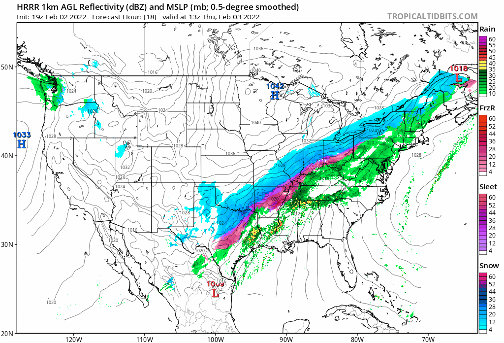
18z Euro would snow a ton on the lakeshore if extrapolated further and would be a massive sleet and ice storm north of I-70 south of the snow.
-
Lol. 24-48 hours out is SOP. No reason they won’t be issued in higher confidence areas at the earlier end of that. If BUF was farther west they would’ve pushed for a watch today and others may have jumped in but no one pushed hard for it surrounding us today. It’s Sunday anyways, they can be hoisted early Monday.
-
If we’re being honest here it’s possible the 18z GGEM and ICON aren’t the most confidence-inspiring duo.
-
Not sure if there was collaboration on that or not, but these insane numbers rarely pan out as modeled, plus track will change, so here we are trying to be aggressive enough to get people to stay tuned to the forecast but vague enough to not put amounts in anyone’s heads yet. Once models show all time record snow storms and a ton of ice it’s hard to stop that hype train from getting into the public sphere but we can try to at least steer the message…try the key word.
-
Leaned a little more amped in the forecast idea here at CLE today…suspect we may inch the IP/ZR a bit farther N with time but as a start have it for the southeastern 2/3rds of the CWA…not quite to Cleveland yet but suspect it gets there. Snow grids don’t go out through the whole storm yet here with the heaviest in OH being Thursday so the grids only mean so much for now here. Like the 12/18z GFS, 0z CMC, 12z Euro as a start for rough conceptual ideas and adjust from there. Feel like PV adjustments noted on the Euro yesterday that led to the SE bump have stopped today. Feel that with a ridge off the west coast and SE ridge/+NAO that a system heavily driven by WAA like this will want to edge a bit more amped and NW unless that PV just shears out the wave more…currently seems unlikely but that’s what to watch if you want a colder trend.
-
Had the AFD and grids today. Suspect it’s a sleet fest near or just south of Cleveland (with 12-24” of snow just north of the sleet) and a lot of ice in Canton and down towards central and SW Ohio. Feel the more consolidated and amped models are the way to lean…sort of liked a mix of the 12z/18z GFS, 0z CMC and 12z euro as a start for a conceptual idea…and go from there. Fear it trends a little more north from where we are now.
-
Definitely has been fun to be on the forecast desk the last few days, and a good learning experience...we'll see how things trend the next couple of days. Tried to leave things as open ended as possible today and just give comments on what would happen if we saw the snowier or wetter solution pan out.
-
The 0z NAM would definitely be GFS-y if ran out a little further. For whatever it's worth.
-
I honestly don't know then. If it was that many, would have to assume it would've been investigated and would say it's relatively shameful if it wasn't. Or perhaps that figure is using data that hasn't been updated recently. With snowfall and tornado climatology and records I've come to realize that we "do the best we can" (in most instances) but that there's too many variables involved for them to be more than rough approximations...sadly.
-
It may be up to the state climatologist and / or local NWS offices to submit possible records for verification as well. In NJ last winter someone measured more than the state record by a couple of inches in their backyard in a huge Nor'easter we got. Mt Holly put it in their PNS and the state climatologist did investigate it. The end result was snow blowing off a roof may have inflated the total so it was tossed. Then again the state climatologist also thinks the NJ state record (that is like 100 years) wasn't properly measured either so who knows with some of these things.
-
That's an interesting comparison. I do remember the last second NW trend with that one. We were initially slated to get snow here in Cleveland...and the GFS tried holding on until about 18 hours out...we got mainly rain (as you'd expect with an SLP track right over our heads) and ended as a bit of wind whipped snow as the Arctic air poured in. Interesting comp to this one because it was also a fairly low amplitude shortwave with Arctic air behind it. If the GEFS/GFS is correct and the PV exerts less influence we could see similar trends with this one given how warm and how much ridging there will be over the eastern US in front of it. I do feel that the PV being located farther east over Canada in this case and higher heights over the Plains will prevent as meridional of a track in this case, but if the PV influence is weaker then the Euro is in all likelihood too far south at the moment.
-
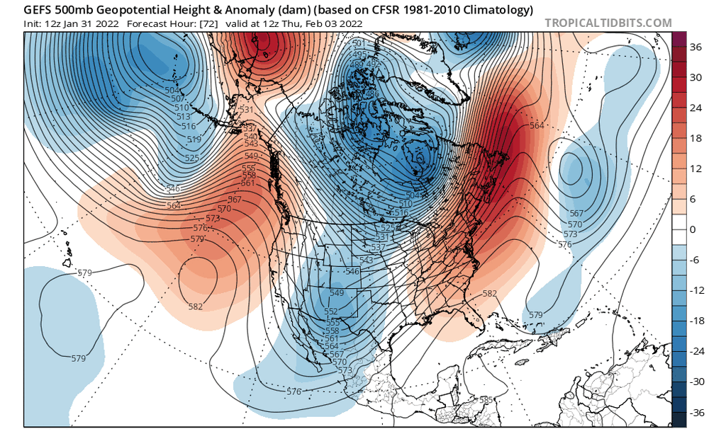
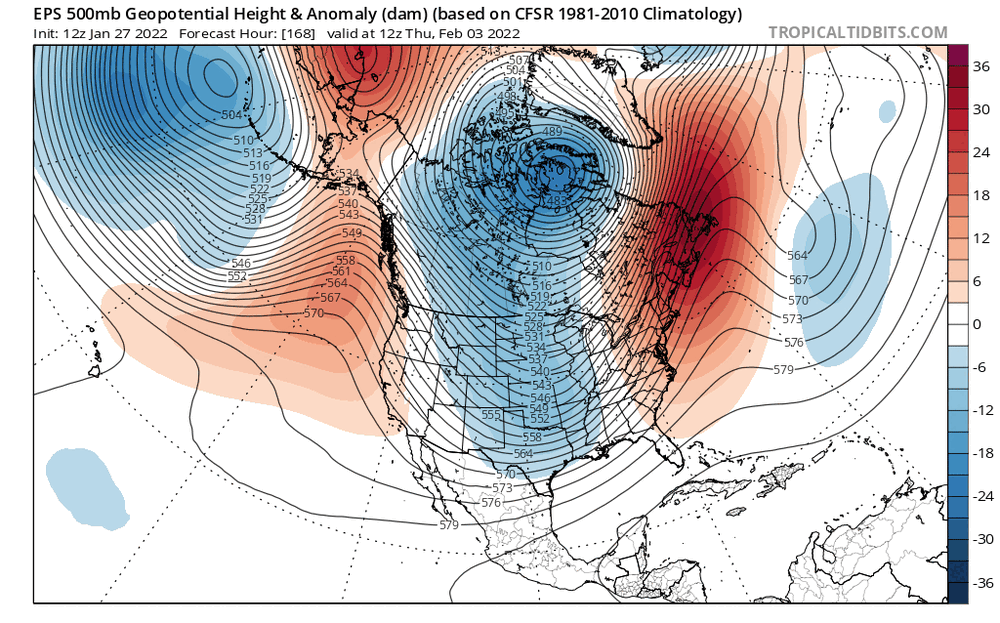
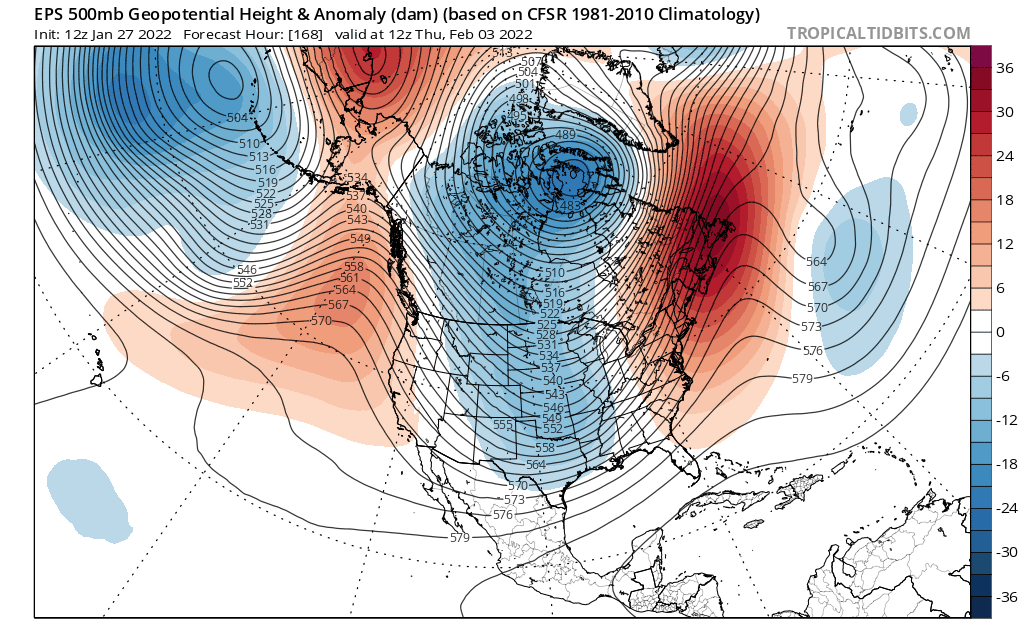
I honestly don't have a great feel at the moment for which way this ultimately trends either way. Pretty interesting that the GFS and GEFS are holding amped (and if anything the GEFS have trended a bit more amped today) and the Euro and EPS are going the other way. The GFS and GEFS have been competitive with the Europeans the last couple of winters. Gut feeling with a +NAO and ridge axis off the west coast would be a NW trend. That may still play out here. But, here's what the EPS is doing at 500mb over the last 3 days worth of 12z runs... Trending towards the PV near Hudson Bay exerting more influence, with a lobe of it extending towards the Upper Great Lakes. On top of that, it's ejecting the shortwave out of the Four Corners a little slower...though, is that just EPS bias? Now here are the GEFS trends over the last number of runs: It has trended towards ejecting the shortwave a little slower, but is trending towards the PV over Canada exerting LESS influence. Feel like the trend to eject the trough slower is legitimate, and that would argue for a somewhat flatter solution IF the PV over Canada exerts more influence. We need to watch trends in both aspects, but the PV influence seems to be causing these big differences. At this point I have no clue. A worst case scenario would be the PV pressing down but a fairly amplified trough still ejecting, as that's where you get the GFS solution with stronger WAA aloft as the surface stays cold, meaning someone gets a lot of that QPF as ice.
.thumb.gif.0950177be1ee6ec5974923e2bd2f5d73.gif)
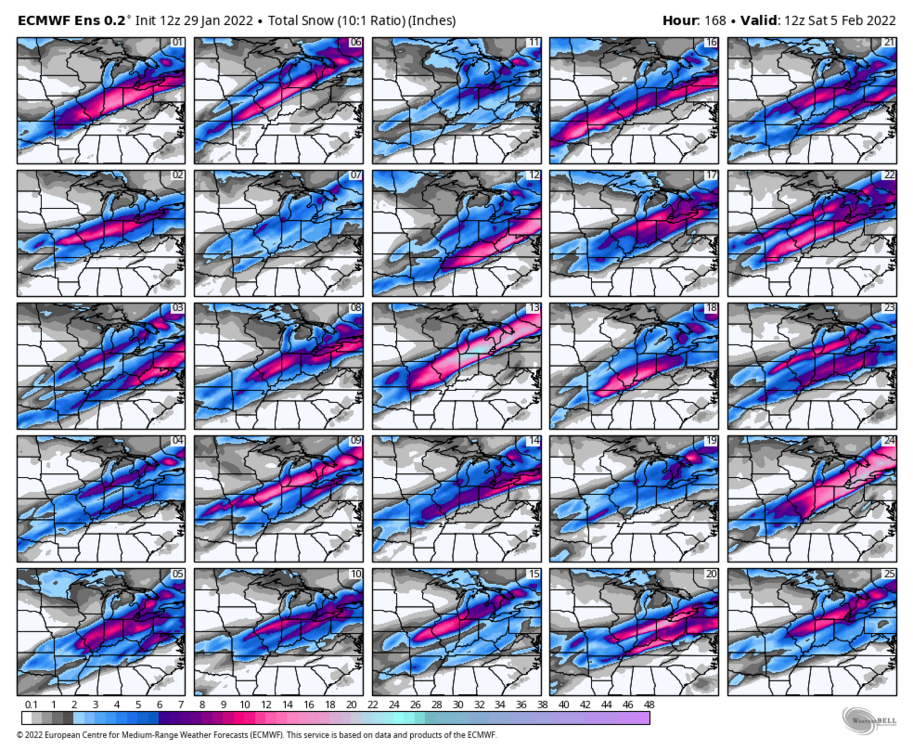
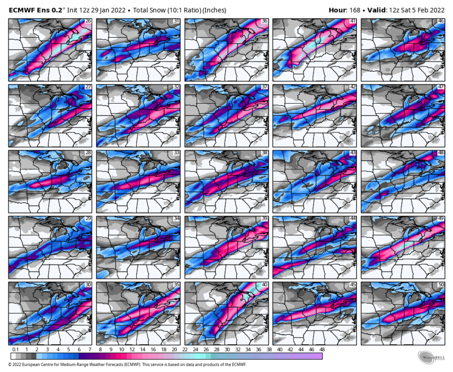
-
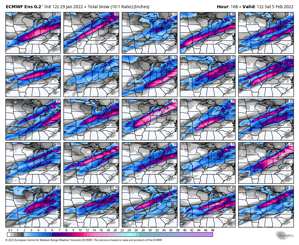
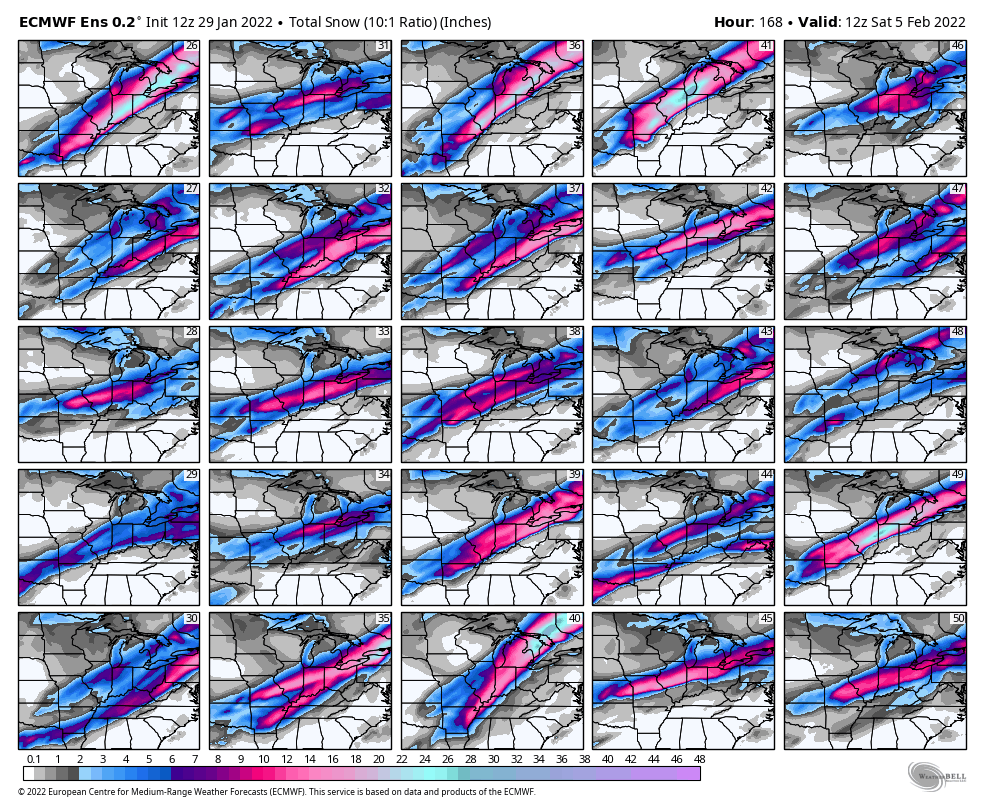
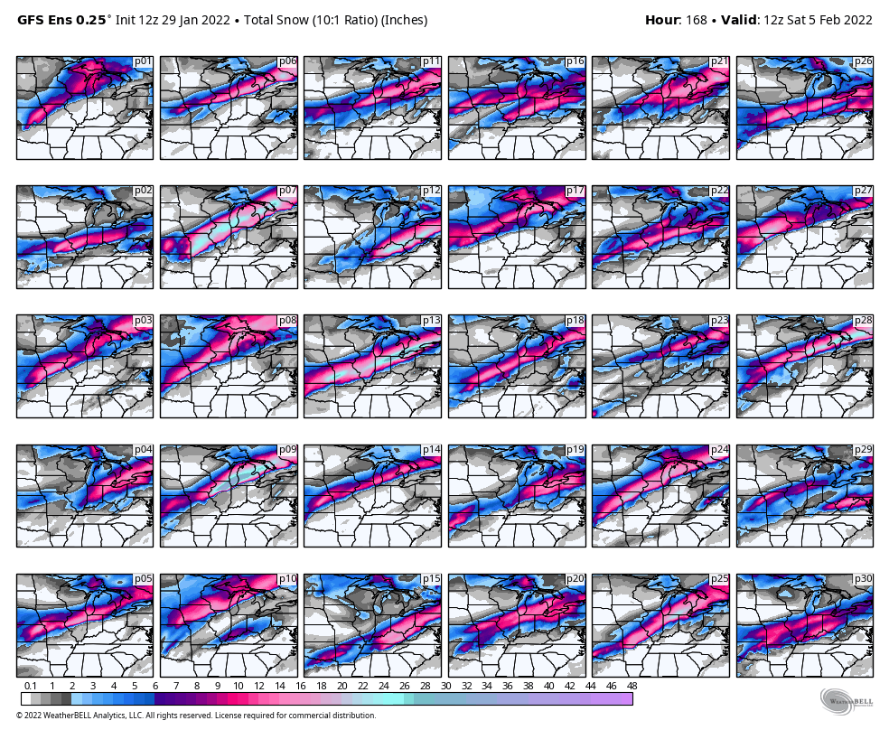
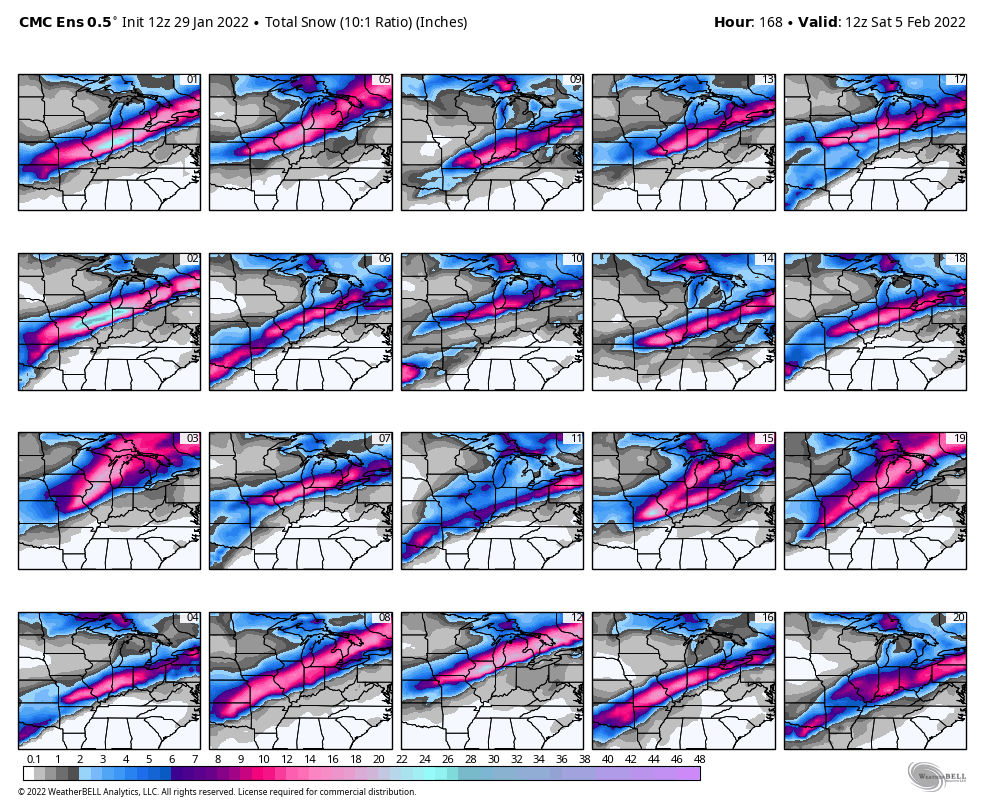
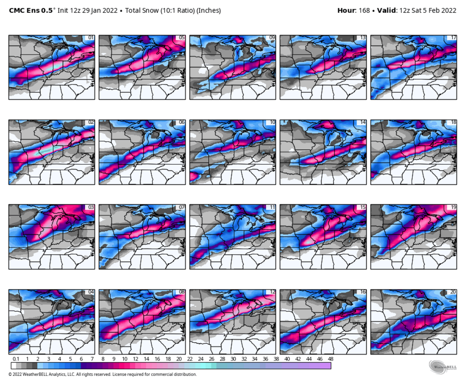
Edit: ninja’d Here are all the 12z ensemble individual members. Euro is definitely a southern outlier though has modest support. Feel with such a tight compressed height gradient that if this ejects slower or not enough at once that progressive/SE isn’t unreasonable, but if it amps at all it’ll try cutting until it runs into the PV west or SW of Hudson Bay. With the overrunning ahead of the storm, strong gradient resulting in plenty of jet support, and deep feed of moisture high QPF is a very good bet…and a zone of icing is likely. At a certain point if this trends way more progressive the QPF and ceiling would become less impressive but there’s minimal ensemble support towards something like the 12z UKMET for now. UKMET is trash anymore anyways.


.gif.ba13e587ee9f63faa382e5a889913686.gif)