OHweather
-
Posts
5,046 -
Joined
-
Last visited
Content Type
Profiles
Blogs
Forums
American Weather
Media Demo
Store
Gallery
Everything posted by OHweather
-
Winter 2021-22 Short/Medium Range Discussion
OHweather replied to Chicago Storm's topic in Lakes/Ohio Valley
I'm very happy to be back where I'm from at a job I always wanted...still busy getting settled in and briefly living at home to save a bit of money and take my time finding an apartment, which let's just say is an adjustment after being able to do whatever I wanted whenever I wanted for 5 years living on my own. But that stuff will work itself out, very happy overall to be back. Not to hate on NJ but it wasn't home and NW NJ isn't all that exciting (aside from surprisingly hilly and wooded terrain to do outdoor activities in). -
Winter 2021-22 Short/Medium Range Discussion
OHweather replied to Chicago Storm's topic in Lakes/Ohio Valley
The be frank, the pattern through the next 10 days or so looks like horseshit for snow potential here in the Midwest, outside of LES belts now and later this weekend into early next week. Pacific puke floods the whole country after the Arctic blast early next week. But, the ensembles are in pretty remarkable agreement for so far out in retrograding the ridging after mid-month as the Pacific jet backs off a bit, putting it just off the West Coast and building it towards AK. Also signs of a somewhat more active sub-tropical jet too. With a neutral to even positive NAO and ridge just off the West Coast, it would turn more active in the Midwest somewhere between January 17th and 25th (with some LES possible slightly before it turns more favorable for larger system snows). The GEFS could be colder and maybe give places along and south of the Ohio River a better shot at snow, the Euro may be more of a mid-Mississippi Valley to Great Lakes deal for where it'd be snowiest. Anyways, let's see if this look can move up in time on the ensembles over the next several days. EPS: GFS ensemble:
-
Yeah, feel better about the band getting from Cleveland down to Solon before breaking up tomorrow morning. Don’t think I get much down in Reminderville though, I think I’m too far south. Does seem like the RGEM heavy band into Lake County isn’t going to pan out. A general 2-4”, locally higher for the primary NE Ohio snowbelt seems like a good call IMO…similar to what we had yesterday, probably an inch lower overall than what the grids came up to in the afternoon.
-
I did a decent chunk of the AFD and grid editing for the LES this afternoon (the AFD was a bit too long given what this event is, but it was my first real LES one so eh oh well). The RGEM was in the blend I started off with for the QPF, along with some of the prior forecast, WPC QPF guidance and a couple of other hi-res models. It was hand edited to smooth out a couple of bullseyes and shift things a bit. The RGEM QPF would’ve given about a foot or more of snow from NE Cuyahoga through much of Lake with the ratios we had in the grids. I am worried that with a weak flow and decen0t lake aggregate trough over the Great Lakes that bands will struggle to push inland. It’s an amazing discrepancy between the RGEM which has heavy QPF right along the lakeshore and many other models that push things well inland and have much less QPF Friday and Friday evening. My hunch is that the RGEM is onto something but that it’s too focused and heavy with the QPF and a bit too close to the lake. The soundings get marginal by midday Friday so if there isn’t any organized banding it may get paltry pretty quickly after the trough moved through. We shall see what the model runs tonight and tomorrow show and see if models converge on a solution one way or another or not.
-
Yeah, the synoptic snow is missing us, blegh. The lake effect late Thursday night into Friday looks fairly interesting but brief...advisories seem likely at the least for most of the primary NE OH and NW PA snowbelt and some guidance supports the possibility of a focused band or two late Thursday night into Friday that can produce warning type amounts. My thought is NE Cuyahoga, Lake, northern Geauga, Ashtabula and parts of Erie Co do best with it. I had the long term portion of the forecast today at CLE so those POPs in your forecast for early next week were "made with love"...some lake effect seems like a slam dunk early next week, but the airmass is going to be pretty cold and dry and it is in and out quickly. Wasn't hard to go over 50/50 for the POPs in the heart of the Snowbelt for it as I think snow is much more likely than nothing for that period, but I'm not sold on it being significant yet. But at this point I think we'd take enough to solidly cover the ground and run.
-
Didn't get much out of all of this here...a couple tenths yesterday morning and some freezing drizzle in the afternoon. Lake effect was very meager, just some flurries last night and this morning (still ongoing). Most non-GFS models still advertise up to a few inches of synoptic snow followed by some lake effect later Thursday into Friday, so it seems like a half decent shot at something more substantial.
-
Between some minor lake effect Sunday night / early Monday, and another (brief) shot of Arctic air to end next week (with models trying to spin up a low in front of it) there is a bit of stuff to track here coming up...though, let's get today's 12z GFS and Euro solutions a few days closer for the end of next week if we can... Shameless self promotion but the first AFD I wrote was this afternoon and touched on both systems plus another warm and rainy system. .SHORT TERM /SATURDAY THROUGH SUNDAY NIGHT/... Active weather will ring in 2022 as a wave of low pressure drags a cold front through the region Saturday into Saturday night, ushering in a brief blast of more seasonable weather for the second half of the weekend. The models remain fairly consistent today with the overall evolution of the cold front and wave of low pressure. There has been a modest trend to slow the system down, so we have nudged back the arrival of categorical POPs Saturday morning across the northern half of the region, though overall the message for Saturday remains the same...yet another warmer than average, rainy "winter" day across the region. Strong isentropic lift beneath the right-entrance quadrant of a 150+ knot upper-level jet streak will maximize across the region midday Saturday through the afternoon, and this is when the steadiest and heaviest rain will occur. All non-NAM models agree on keeping the surface frontal boundary well south of our CWA, which would keep the rain more stratiform in nature across northern OH and northwest PA. That would keep overall QPF and rates fairly manageable. Given the recent wet weather area rivers will rise, but overall QPF amounts of 1" or less shouldn`t cause significant hydro issues. The NAM has a notably more amplified solution (stronger, slower, farther northwest low track)that pushes the warm front all the way to Lake Erie. While that solution would bring convection into the picture and greater concern for hydro issues, the overall pattern is progressive and the upper trough with our system is positively tilted. Given the consistency of the other guidance and the overall pattern, we believe the NAM is significantly too amplified and largely rolled with the rest of the guidance suite which was more consistent with the going forecast. Colder air filters in behind the front Saturday night into Sunday, with a bit of snow possible across the region. The progression of cold air will be gradual, reaching Toledo by Saturday evening but not getting to Canton or Youngstown until Sunday morning. There appear to be two opportunities for some light synoptic snow across the area. The first opportunity will be in far northwestern OH Saturday evening as colder air begins filtering in before we lose better synoptic moisture and support overnight. This may produce some accumulations in the Toledo area. We`ll watch the timing of that changeover closely, as if it occurs a bit quicker Saturday afternoon when greater QPF is left there may be a bit more snow. Colder air gradually works into more of northern OH and northwestern PA overnight but moisture / lift in the DGZ are weaker by then so accumulations elsewhere Saturday night, if any, will be very light. The core of the upper trough pushes through the area Sunday morning and early afternoon and may bring just enough synoptic moisture and lift for a brief round of light synoptic snow or snow showers, with the entire region getting cold enough to mix with or change to snow by midday Sunday. Any accumulations with this push of snow will be light, though the entire region stands a shot at seeing flakes on Sunday. A lull is likely later Sunday before some lake effect sets up into Sunday night. As the core of the coldest air (850mb temperatures over the lake of - 12 to -15C) moves over the lake Sunday night there will be some minor lake effect snow with a north to northwest flow. The mixed layer over the lake will only be about 5k feet deep with a strong inversion and very dry air above it...which along with a short fetch will limit the lake effect potential. However, with lake to 850mb temperature differentials nearing 20C and steep lapse rates getting into the bottom of the DGZ, there`s likely to be enough "juice" for lake effect snow showers, especially if we can tap into some Lake Huron moisture. High chance to likely POPs remain in the forecast for both the primary and secondary Snowbelts for Sunday night for this lake effect. Snow amounts will be light, but will probably whiten things up a bit in parts of the Snowbelt, especially if a weak connection to Lake Huron does indeed develop. Outside of the Snowbelt it will largely be dry later Sunday and Sunday night as the upper trough shifts east and high pressure begins building in. Given the north-northwesterly flow off the lake the Central Highlands may try to wring out some very light flurries or a brief snow shower into Sunday night, so that is the one area outside of the Snowbelt where some low POPs were maintained after the departure of the synoptic moisture / lift. Lows Saturday night will range from the upper 20s in NW Ohio to mid 30s near CAK and YNG. Temperatures steady or falling into the upper 20s/lower 30s on Sunday...it will feel like winter. Sunday night will be one of the coldest nights of the season so far, mid 10s in northwest and north-central Ohio to the lower 20s in the Snowbelt. && .LONG TERM /MONDAY THROUGH THURSDAY/... The long term begins on Monday. Some minor lake effect may linger in extreme northeast OH and northwest PA into Monday, but the surface high will really be nosing in by then, clamping down on the lake effect and causing what`s left of it to gradually shift east and out of our area during the day. Any additional accumulations on Monday will be minimal. Outside of the primary Snowbelt expect plenty of sunshine on Monday, though it will stay chilly with highs in the upper 20s/lower 30s. After the lake effect ends, the area will be all dry through Tuesday evening with temperatures gradually moderating on a southwest flow ahead of our next low pressure. This low pressure will track well to our north but push a cold front across our area later Wednesday or Wednesday night. Models disagree on the exact evolution of this, so we maintained modest POPs for mostly rain on Wednesday, with cooler air moving in behind the front Wednesday night. The next system follows quickly Thursday into Thursday night, as very cold air drops into the Midwest and encourages a low pressure to develop and track towards the Ohio Valley or southern Great Lakes. Models have been bouncing around with the track and intensity of this system quite a bit, typical for nearly a week out, so for now the forecast has chance POPs for rain and snow showers on Thursday. However, longer range ensembles do have some probabilities for accumulating snow across the area with this system so it`s worth keeping an eye on for wintry potential. A chunk of Arctic air and lake effect snow potential likely follows behind this system beyond the end of the forecast.
-
It's snowing pretty good and sticking to all surfaces here, but even around here you can notice a difference between hill tops and low spots. Very elevation and rate dependent. The airport is about to get a brief but heavy burst and is down to 34, let's see if they can manage 0.1" out of it...
-
Yeah I like the trends on the 12z models for late Tuesday...it will be above freezing when it comes in, but models are showing good lift in the DGZ and plenty of low-level dry air...it will take a bit to saturate, but that process will cool the low-levels enough to allow precip to start as snow. I think CLE has a decent shot to get "on the board" for this month and it could end up being a quick 1-3" in the hills. It's a fickle set-up so let's see if the 0z models hold with it, but as it's shown I think there's enough lift and wet-bulb cooling potential to get accumulating snow.
-
Got the lightest of slushy coatings this morning before changing to rain...maybe was briefly 0.1" but I didn't see it I'll go with a T here. We've gotten about 0.3" of snow at my house in Reminderville since I moved back on December 4th, which is hilariously pitiful. We'll start getting more snow soon, the torch is almost over. We'll see if it's a "good pattern" or just "snowier than it's been"). Looks like extreme NE OH into PA got a nice slushy thump into the AM commute this morning, not that it does much to dent their seasonal departures there but more than nothing. Tuesday PM is close to trying to thump briefly again before changing to rain...I'm thinking extreme NE OH and NW PA can, we'll see about the CLE area. If surface temps aren't too warm a thump of wet snow could be measurable at the airport. I'm not sold on the airport getting measurable but it's within the realm at least.
-
POLL: 2021-2022 Season Snowfall Total @ ORD
OHweather replied to cyclone77's topic in Lakes/Ohio Valley
Yeah I'd think with the PNA relaxing and the cold air deepening to our west/northwest Chicago (and Detroit) will get in the game...it should eventually snow in Cleveland too, though we're dangerously close to not getting anything measurable in December at KCLE which hasn't happened since the 1930s IIRC. Eek. -
POLL: 2021-2022 Season Snowfall Total @ ORD
OHweather replied to cyclone77's topic in Lakes/Ohio Valley
I'm forever optimistic about these things, probably somewhat to a fault, but the pattern for the foreseeable future looks like big cold dumping into the west, a little lingering SE ridge, and a bit of NAO blocking which will keep storms from cutting to the UP of Michigan. If Chicago can mix a bigger storm in at some point they have plenty of time to catch up assuming that sort of pattern lasts a few weeks. -
Merry Christmas to you as well! Last December was definitely a very good month with two major storms and a few smaller ones. Either way, January should be better than this month (and models seem on track to start bringing in colder air just after the New Year), so we'll see what that can bring to our area.
-
CLE is currently sitting in a tie for least snowiest December on record (T)...may be a little mix late Sunday night or early Monday in NE OH and NW PA but I don't think CLE has a shot at measurable snow from it...next wave of precip arrives early Tuesday and may briefly mix on the very front end but again, looks unlikely to be measurable for CLE. It gets trickier Thursday and Friday as it starts getting chillier, but Thursday a wave of low pressure looks to develop well to our SE and the next wave probably doesn't bring any precip chances until Saturday. So, this may go down as tie for least snowy December on record (a record that hasn't occurred anytime recently). It will get colder and snowier the first half of January (kind of hard not to) but at this point we're in a big hole to start winter...feel like that's been the case more often than not recently.
-
Some Thoughts on the Winter 2021-22 Outlook
OHweather replied to OHweather's topic in Weather Forecasting and Discussion
East based La Nina with a -QBO "should" help, but so far the pattern isn't reflecting it. Getting a -AO/-NAO or -EPO would push more cold into the CONUS and increase snow potential. That's not imminent though...first window for it appears to be after mid-December. -
Some Thoughts on the Winter 2021-22 Outlook
OHweather replied to OHweather's topic in Weather Forecasting and Discussion
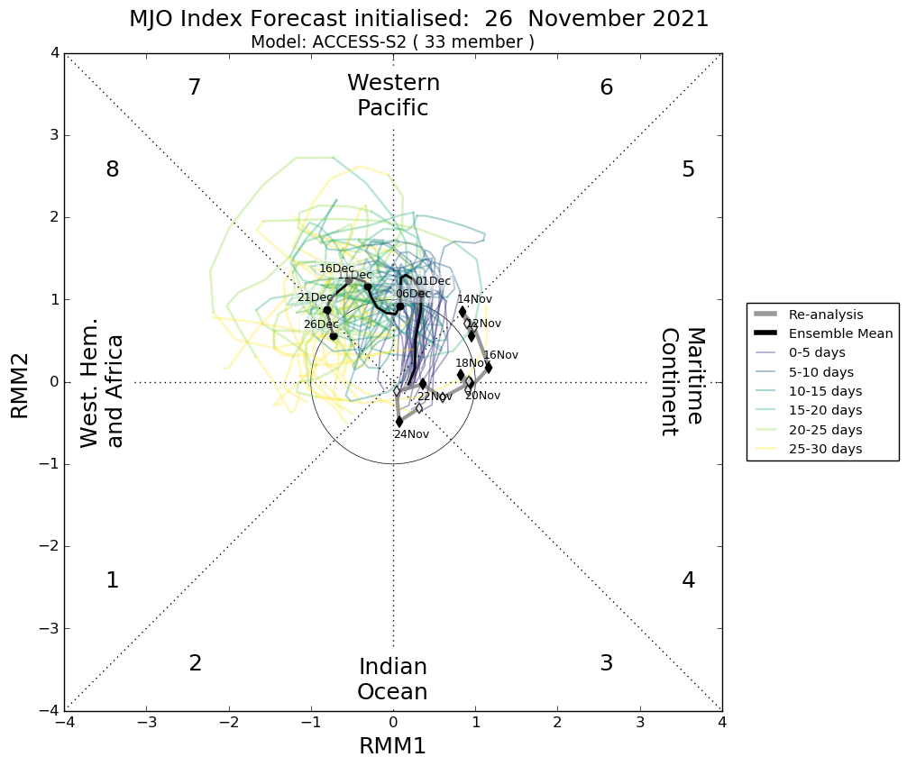
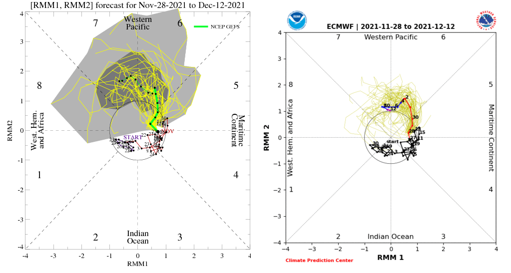
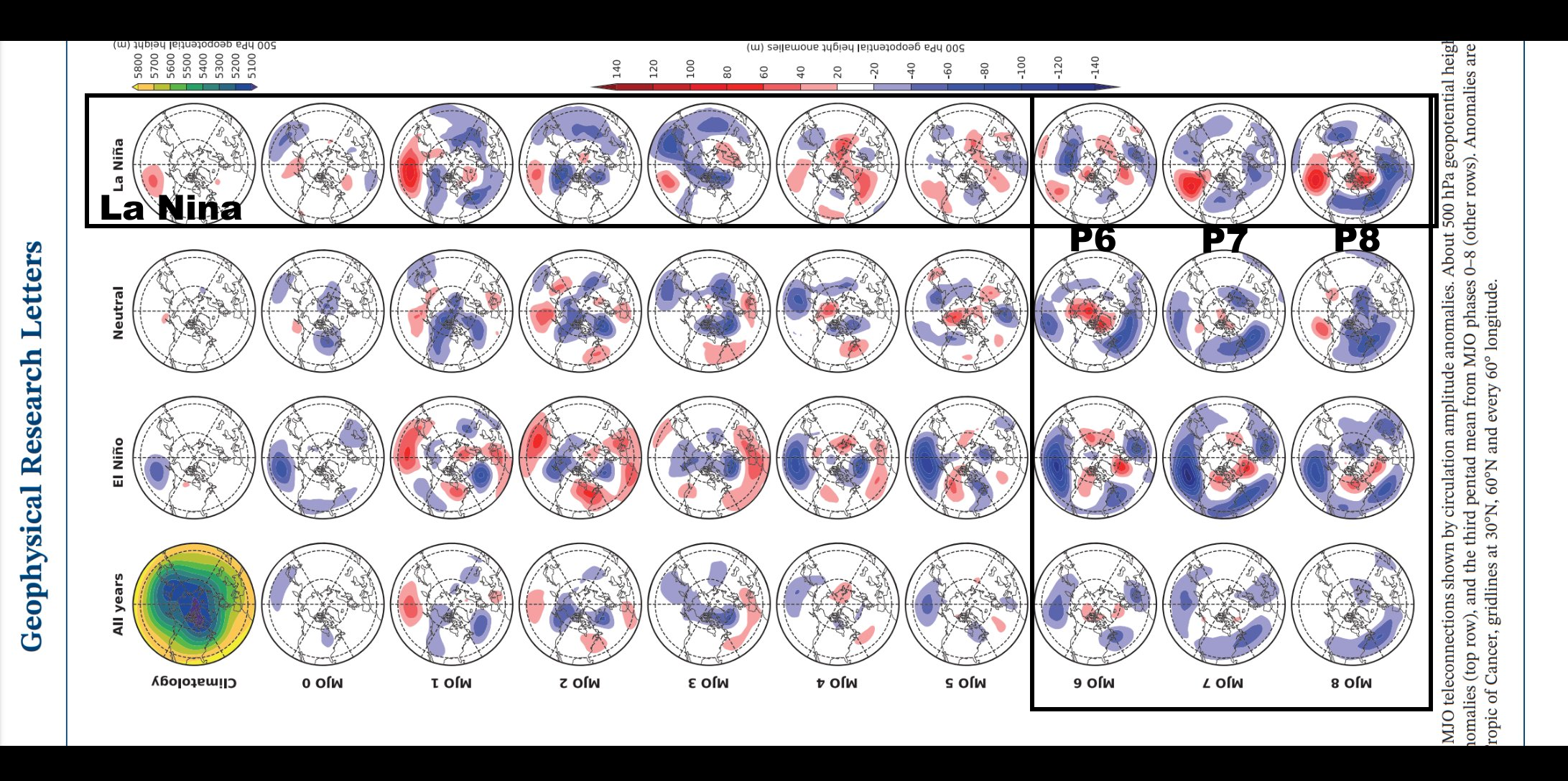
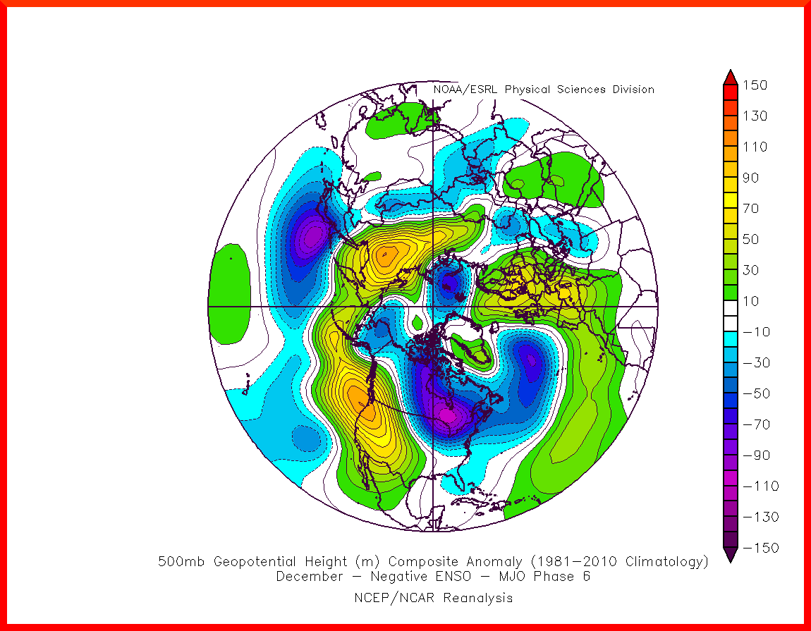
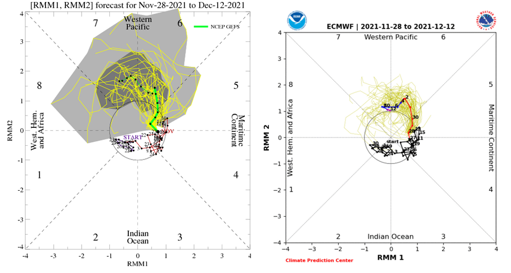
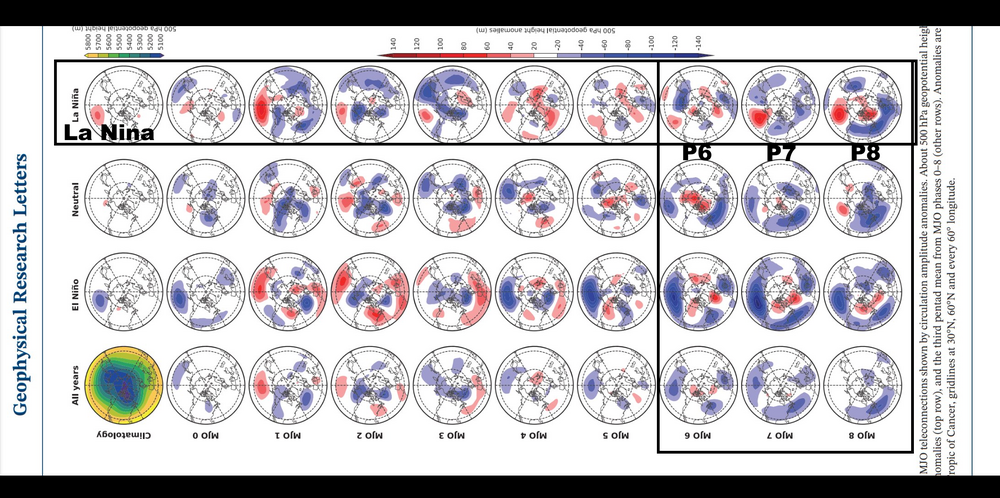
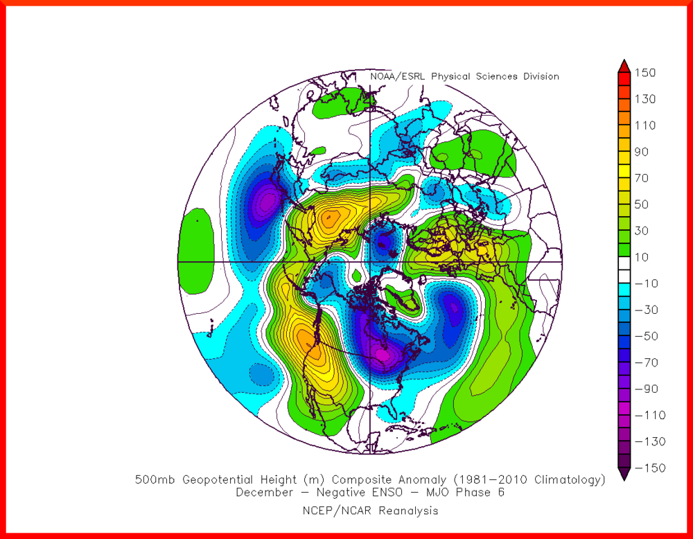
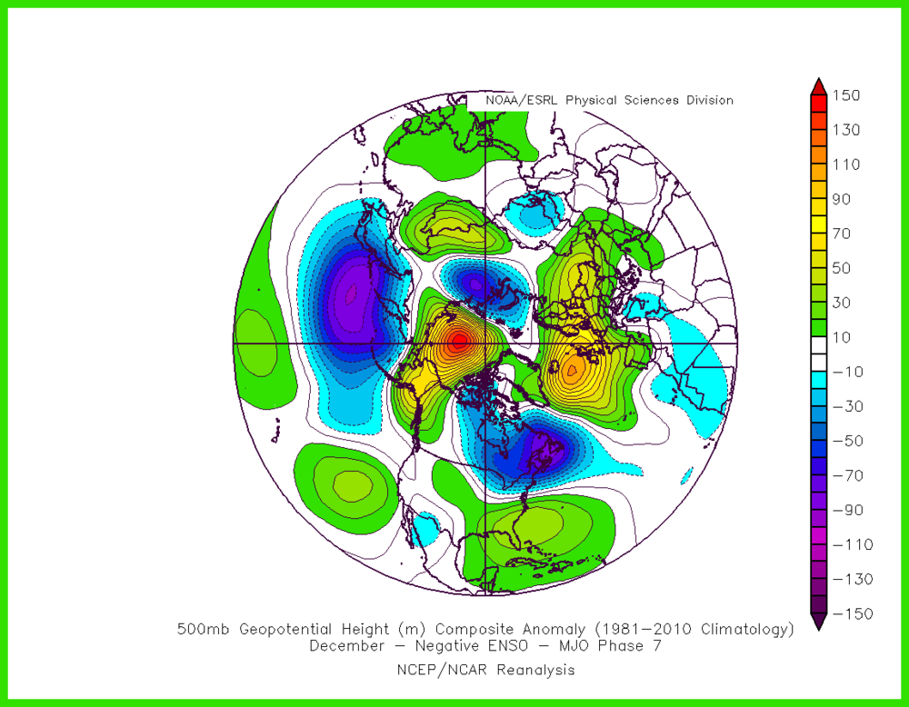
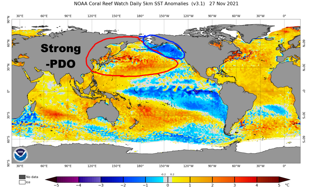
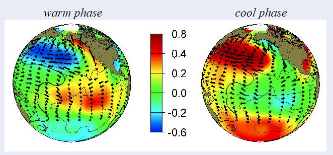
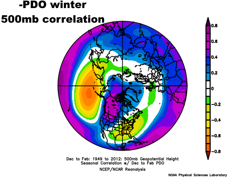
Wanted to touch on the current pattern, the longer-range ensembles, and what I’m watching for (both cold and warm) moving through the rest of December…some of this stuff may have implications deeper into winter depending on how it does (or doesn’t) impact the stratospheric PV. We can quibble about if the current / upcoming pattern over the next couple of weeks is good or bad. With a legitimate cold source to tap over the western hemisphere, with a lobe of the PV near northern Hudson Bay and frigid conditions over AK and western Alaska, any cold shots will continue to have bite to them. The mean trough axis is oriented towards the NE U.S. and that isn’t changing for the next couple of weeks, so despite Pacific influence that’s flooding almost all of the rest of the CONUS, the Upper Midwest, Great Lakes and Northeast will be a relatively cool spot…parts of that region may continue to average out to colder than normal on the mean. It’s certainly eating into the torchy pattern for those regions. With that said, the EPO remains persistently positive overall, with a -PNA and AO and NAO that are now more positive than they’ve been the last week or two. The teleconnections suck. And no, that ridge extending from the Pacific into the west coast is not a +PNA. You need an Aleutian low for a +PNA, we have an Aleutian ridge in the means coming up. With legit cold over Canada and the trough axis sitting near the Northeast we’ll continue to get cold to bleed into our region. But in terms of snow, this pattern can work from the Upper Midwest and Great Lakes to New England, but it sucks for the Ohio Valley and Mid Atlantic. NYC could get lucky but I wouldn’t roll my dice on it if I had other options. It’s not a warm pattern for the NE, but that’s about the only corner of the CONUS that isn’t going to be mild. It’s not the pattern I anticipated when I went with a colder and somewhat snowy winter for the region, and I doubt anyone else who went against the mild outlook anticipated a persistent strong +EPO either. Maybe we keep getting lucky with the cold source to our north and stave off any sort of prolonged mild spell in the Northeast, but it’s not a great pattern for snow for a lot of areas. For fun, here are last night’s 10-15 day EPS and GEFS depictions…first with what’s wrong with the pattern marked: The main lobe of the PV being on our side of the world, with the trough axis tilted towards the Northeast is staving off a torch for us, but most of the teleconnections are not what we want for a cold or snowy pattern overall, despite some differences in the two outputs. The +AO, NAO and EPO are favored with a strong lower stratospheric vortex, which is quite likely to remain in place for at least the next 10-15 days, with perhaps some hope for change at the end of the run: Now, a look at what may seed some future changes on the ensembles if things break the right way… The GEFS is a little farther along with these late in the run than the EPS. Both agree on a Scandinavian/Urals ridge, which historically is something that can jab at the stratospheric PV. If we can ever get the Asian lobe of the PV to displace farther south, it would really increase the potential for both jabbing at the PV and also make it easier to flip the EPO. Both models have a strong ridge south of the Aleutians…if the PV dips into eastern Asia, there’d be room for that to surge towards AK. Also, if the Scandinavian ridge persisted it’s something that could eventually retrograde towards Greenland and EVENTUALLY flip the NAO back to negative (probably not until at least mid-December though). As has been discussed by many in the last week or two, there are still signs on many models of MJO movement during the first half of December…first phase 6, then likely 7 around the second week of the month, and some hints at phase 8 if it’s strong enough to keep chugging through late December: Both of these plots have made some rounds recently…but, in La Ninas, both MJO composites show that phase 6 doesn’t really flip the EPO, but phase 7 may, and phase 8 would up the ante for Atlantic blocking too: In the face of these, it’s not too alarming that the EPO is staying positive through the first week or so of December with an initial phase 6 MJO. Though, it’s worth noting that the pattern over the NW Pacific is a fair bit different in early December than the phase 6 MJO composites. A possible explanation is the PDO. It’s strongly negative, and a -PDO in winter supports a -PNA and +EPO (and is pretty ugly in the AO and NAO domains too): There are exceptions such as 10-11 (and even 08-09 wasn’t awful with a -PDO and La Nina), but it’s somewhat concerning that the Pacific pattern looks quite a bit like a -PDO pattern, with a strong -PDO in place. Overall, much of the CONUS will be mild through the first half of December in my opinion, with the relative exception of the Upper Midwest, Great Lakes and Northeast. That said, it’s still not a great pattern for snow south of New England. There are potential “seeds” of more substantial change though, and if things break the right way we could quickly flip to a much colder pattern overall at some point during the second half of the month with potential to carry that into January. However, part of me worries that with a strong -PDO we are kind of stuck with the pattern we’ve been seeing. I’m in a wait and see stage at the moment.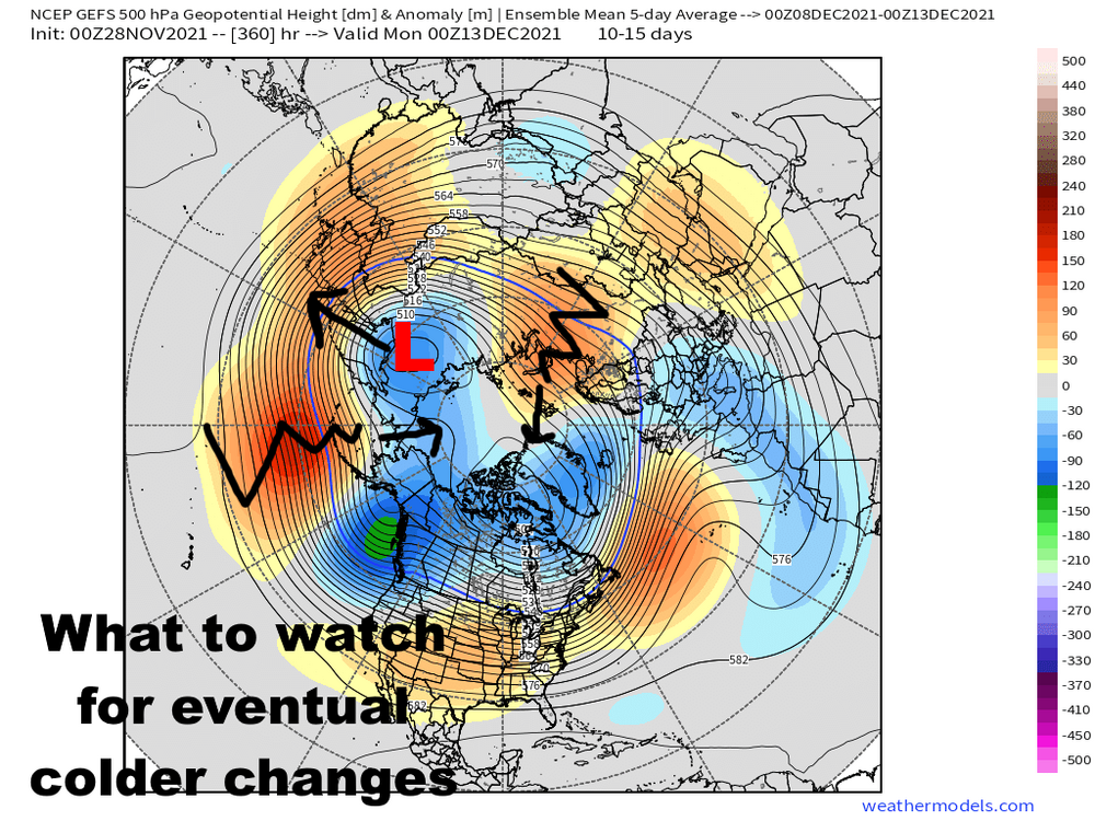


-
Barely got to drawing this before snow starts accumulating... Lot of mixed signals on this one. There will be an uptick the next several hours as a surface trough pushes inland. Thermodynamics support very squally precip with this trough, with instability and moisture to over 10,000 feet and through the DGZ. There's also very strong synoptic support. However, 850mb temps are -7 to -8C with above-freezing surface temperatures. If there's any sort of organized banding snow could quickly add up in this window, but the trough pushes inland fairly quickly so I'm not sure. Best shot is probably into NW PA, though maybe there's some transient organization east of Cleveland too that can lead to some accumulations. Outside of any organized bands with this first push, amounts will be an inch or less from quick squalls. Probably little near the lakeshore as it may mix with rain or just fall as graupel that doesn't add up quickly. Disorganized lake effect snow showers should continue behind this initial push, but there's a period of synoptic sinking motion behind the initial trough and there's some shear, so accumulations for the early-mid evening hours probably won't be anything notable. There's another subtle vort and wind shift around midnight. With a WNW flow ahead of it, convergence may increase enough from Lorain, Cuyahoga, and northern Medina east into the interior Snowbelt of NE Ohio and NW PA for a brief but decent uptick in snow organization and intensity ahead of this next wind shift. Thermodynamics aren't quite as favorable for intense precip as later this afternoon but are still sufficient with inversion heights near 10k feet and moderate instability with respect to the lake. What may allow for heavy rates in this window is a Lake Huron connection, that initially will be going into NW PA but should swing into at least Lake / Geauga but perhaps even eastern Cuyahoga County as the winds go NNW behind that trough. That connection may linger overnight and allow for a band to persist into early Monday. Otherwise, ridging builds in quickly late tonight into early Monday and gradually shuts things down. Tricky to figure accums with somewhat marginal temperatures during the day today (and even tonight it will be iffy close to the lake), shifting winds, some shear for most of the event, brief duration and only quick hits of synoptic support...but, the thermodynamics are a good bit more favorable than the last event. NW PA, despite underperforming some with the last event, probably has the best shot both this afternoon (longer fetch and more terrain may help accumulate with the marginal temperatures) and later this evening (they get the Huron connection first), so someone there may verify the LES warning and get over 6". In NE Ohio I kept most areas to 1-3", with less near the lake. Parts of Medina may do OK with the uptick late this evening into the overnight so did paint in 1-3" for much of the county. Otherwise, went 3-6" for much of Geauga figuring you may get some accumulation this afternoon, plus the Huron connection tonight, along with enough terrain to help accumulate despite the somewhat marginal temperatures. Kept the highest amounts a bit east of most hi-res models per typical model bias with LES placement. I did reflect the potential for this connection to extend into Portage County with southward extensions of the 1-3 and 3-6" areas.
-
RGEM run is pretty good for the Chagrin area with the LES
-
Looks like only a couple of spots in Geauga and Ashtaubla managed an inch in NE Ohio out of the LES...the clipper this evening seems like a safe bet to drop a quick 1-3" on NE Ohio. There's briefly good snow growth so it'll probably accumulate pretty quickly for a couple of hours this evening. The lake effect later Sunday into Sunday night looks interesting, with inversion heights and moisture depth to over 10,000 feet and synoptic support. There is a bit of shear. A Lake Huron fetch may get to at least Lake and Geauga later Sunday night too. If there was less shear this would be a candidate to overperform...even as it is a fairly widespread plowable snow is probably likely with WNW winds going NW and eventually NNW through the event.
-
Some Thoughts on the Winter 2021-22 Outlook
OHweather replied to OHweather's topic in Weather Forecasting and Discussion
I'll be happy if my concern (pessimism) from a few days ago ends up not being warranted. The long range has been tricky this fall...the EPO has tended to bust more positively than modeled, so we've been battling Pacific influence and nothing has locked in, but our cold shots have tended to trend colder as they move up in time on the models. That's happening again with the shot arriving around December 5th (with perhaps a storm in front of it): EPS: GEFS for the same timeframe: While I still think a spell of milder weather follows this shot, as the EPO remains positive and some of the current blocking in other domains relaxes, I do see some hope for a more significant EPO flip the second half of December, along with perhaps another shot for a -NAO. If things still look good I'll try to whip a post together this weekend. My thought, based on having a legitimate arctic tap of air sitting over Alaska and western Canada that has been resulting in decent, albeit fairly brief cold shots, is that if we do ever flip the EPO more negative for a period of time that we'd freeze our butts off. The current pattern could probably work for the Great Lakes and New England to get snow...it's trying a bit now and would do better closer to the heart of winter. But the current pattern would be a struggle for the Ohio Valley and Mid Atlantic even in mid-winter. For those areas to have a more legit shot we do need the +EPO to back off. -
The lake response into NE Ohio has been unimpressive so far...cloud tops have cooled a bit over the last couple of hours and radar returns have upticked a bit. There's currently a bit of synoptic lift from a vort on the backside of the upper trough, and there's another band of weak lift evident on satellite spreading across northern IN and MI ahead of another little vort that will spread across Lake Erie this afternoon and early evening before moving east. You can tell that the strong winds NEOH mentioned are having some effect, as the Pittsburgh radar shows more organized bands well inland. There are a couple of modest upstream lake connections into NE Ohio...one into Lorain, Medina, SW Summit and Stark and another into parts of Lake, Geauga, Trumbull and Mahoning. With some modest synoptic lift at times through this afternoon and winds gradually slackening, we'll see if one of these can develop into a more organized band and drop some accumulations. I suspect accumulations will be an inch or less outside of any upstream lake connections today due to the short fetch, marginal moisture, somewhat strong winds and overall borderline set-up. The hi-res models are trying to latch onto those upstream connections persisting even into the Cleveland area well into tonight...soundings don't support heavy snow, but perhaps that tacks on another local inch tonight. Overall the forecast wasn't very exciting for NE Ohio and so far there aren't signs of any big surprises going the other way. There is a strong band off of Lake Huron curling towards NW PA so I suspect they'll do fine there in the higher terrain.
-
This is a sounding from the 0z 3km NAM at 8 PM Friday in Middlesex County Mass. That'd snow good...
-
Yeah, we'll see some more 30s sneaking into the western basin after another cold few days coming up. Hopefully the lake isn't frozen by the time I move back in a couple of weeks! Probably not, but the cooling happens quick the first few cold shots each fall. Just thumbing through some models and soundings...my overall impression is that this remains a set-up that supports mainly light accumulations in NE Ohio and a bit more in NW PA and SW NY. My thoughts in NE Ohio are that the "low ends" are generally more likely than the "high ends" on my map, but that the higher-end amounts are locally attainable wherever the one or two more organized bands set-up late Thursday night into Friday morning. NW PA likely will do better overall due to more fetch, more lake warmth, somewhat higher inversions and deeper moisture, and perhaps being close to a Lake Huron connection...though in NW PA the higher amounts will still be quite tied to the hillier terrain. Yesterday, the NAM and GFS were both more progressive with the trough and had lower inversions and moisture...especially the NAM...which would have made it hard to get more than a localized inch or two in Ohio. The Canadian guidance (both the global model and the RGEM) were slower and a bit deeper with the trough and had more synoptic moisture and higher inversions, and would have supported locally more amounts even in NE OH. The Euro was somewhat in between. It seems the Euro solution will roughly come to fruition, as the NAM soundings have improved a bit since yesterday but the Canadian guidance now keeps the deeper synoptic moisture more confined to NW PA...but still supports some accumulations in NE Ohio. Even with models coming to some consensus on a middle ground solution, there are still some fairly significant differences on soundings, both model to model and between Cleveland and Erie, with respect to moisture depth and inversion heights, which may make a big difference in snow quality and rates. The NAM (both the 12km and hi-res) still has lower inversion heights and moisture depth than other models. It also has a bit more shear (especially on the hi-res). Here is the hi-res NAM for Cleveland, valid early Friday around event peak and in the afternoon: This sounding, even around the peak of the event, is not great. The boundary layer is only 4-5k feet deep on the model, which doesn't really get into the DGZ. There's some moisture up to 7k feet and the lake-induced convective equilibrium level is about 8k feet, which is into the DGZ, so it'd still snow with this sounding, but it'd be hard to get heavy snow or good ratios. Also note the white line, which is modeled upward motion, is mainly confined to the lower levels and beneath the DGZ. There's also some shear around 5k feet. Through Friday afternoon the NAM quickly strips away moisture and the inversion height gradually falls. The flow slackens a bit below 5k feet, but there's still shear above it. This sounding, with a fairly short fetch and lack of synoptic lift at this time, would probably shut down any accumulations in NE Ohio Friday afternoon outside of any upstream connections, where localized light accumulations could continue with instability and moisture barely getting into the DGZ. Some other models, such as the HRRR and the RAP (HRRR shown), have deeper mixing over the lake and a bit more moisture. There's also less shear. These soundings would overall be more supportive for NE Ohio accumulations. Valid at similar times as the NAM soundings: This sounding has a much deeper boundary layer, to around 8k feet, with lake induced EL's of 9-10k feet. There's also moisture to around 8k feet and a deeper layer of lift on the model. This would allow lake effect to be deeper, perhaps a bit more organized with less shear, and also allow for better ratios due to much better moisture, instability and lift in the DGZ. While soundings on the HRRR at CLE gradually begin to turn less favorable through Friday, even into the afternoon there's still a fair amount of moisture, instability and lift into the DGZ, which would support accumulations under any bands: We'll see which soundings end up closer to reality. My gut feeling, with a 500mb map that looks like this Friday morning, is that the HRRR soundings are more correct with deeper moisture, instability and lift. This is a 500mb map that is favorable for LES off of Lake Erie: The rub is how progressive the trough is, with ridging quickly building in aloft Friday afternoon (especially in OH). But it's briefly quite a favorable synoptic pattern for lake effect late Thursday night into Friday morning. Soundings in Erie are better across the board due to being closer to the heart of the upper trough, a longer fetch, and perhaps some Lake Huron moisture nearby...though the NAM is still relatively less favorable... This is better than the CLE NAM soundings...there's a bit of shear, but there's synoptic moisture to nearly 15k feet, and the instability and modeled lift get into more of the DGZ. While conditions turn less favorable Friday afternoon, they suffice for at least some accumulation potential under any bands through the day and into Friday night in NW PA: Peak HRRR soundings in Erie Friday morning would support heavy and efficient snowfall: Not only is there synoptic moisture to nearly 15k feet, but the boundary layer extends through the entire DGZ which would allow for higher ratios. There would likely be decent upslope enhancement too with that much low-level moisture and instability. Popping "extreme" instability on BUFKIT with that much synoptic moisture would probably result in a period of snow rates greater than 1" per hour in the higher terrain of NW PA and SW NY late Thursday night and Friday morning. Overall, no big changes to my thoughts. I may re-draw my map a bit but want to see some of the 0z hi-res stuff first. My thoughts on changes would be to perhaps expand the 1-2" farther into Medina and Summit Counties...hi-res models are trying to key on a band in that area, and it's not uncommon to get a band from somewhere in Lorain and Medina Counties towards Akron with a 300-310 degree flow. But, does ridging build too quickly down there for good accums? The other thought is potentially removing the 2-4" from eastern Cuyahoga County. Oftentimes with this kind of flow, especially if moisture is an issue, there's a relative gap between a band into the secondary Snowbelt (parts of Lorain / Medina / Summit) and another band into the northern primary Snowbelt (northern Geauga into Ashtabula). If moisture remains more questionable in Cleveland I could see how much of Cuyahoga doesn't get a ton. While not on my map, I feel good for several inches east of I-79 in southern Erie and Crawford PA into Chautauqua County NY in the higher terrain. If there's a Huron connected band on Friday when conditions peak, someone could see warning criteria snow there. I could see an argument for 6-10" of snow from the eastern third of Erie County into Chautauqua County, especially with some light accums probably continuing through Friday night there. And in other news, models have trended more amped with Sunday's clipper. The potential exists for accumulation with the clipper Saturday night into Sunday followed by lake effect Sunday night through at least Monday. Instability appears more conditional to moderate right now, but if the models are right and the system blows up near New England, we may have more synoptic moisture hanging back farther west. Winds will go NW to NNW behind it which could bring a Huron connection into far NE Ohio. Overall my thoughts are a few inches is decently likely in the higher terrain of the Snowbelt in NE Ohio and NW PA from that system, but if it continues to trend slower and Lake Huron is involved it could be significant somewhere. With 850mb temps of -8 to -10C behind the clipper it would be a somewhat lower-ratio lake effect snow, and the lakeshore would see much less. Edit to add:
-
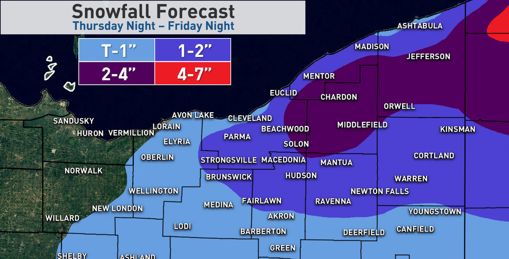
The first of what may be a few opportunities for snow over the next week is Thursday night through Friday night... My early take is that it's an OK set-up (especially for NW PA and SW NY), but far from great. I could see how enough things come together to allow for 24 hour totals over 6" in the higher terrain of NW PA, which would warrant an advisory, but I think in NE Ohio amounts are generally a few inches or less, which is marginal for or even sub-advisory criteria...but would be enough to get everyone back into a wintry mood. Lake effect will get going overnight Thursday night as an upper trough moves over the lake and 850mb temps fall to around -10C by sunrise Friday...and dip a bit more during the day Friday. There will be a few periods where the trough or little shortwaves will add a little bit of synoptic lift...one will be for a few hours after midnight Thursday night as the upper trough initially moves in. Another will be later Friday morning or around midday as a pretty potent vort moves through on the backside of the upper trough, and this will probably coincide with the greatest lake-induced instability and highest inversion levels. Then Friday night into early Saturday, a flat little wave will bring some mid-level WAA and moisture, with 850mb temperatures hanging on around -10C over the lake and low-level convergence persisting over the Snowbelt, especially east of Cleveland. My guess is that there are off and on lake effect snow showers for much of the period from overnight Thursday night through Friday night / possibly early Saturday. I think activity peaks Friday morning - midday, but the set-up Friday night may allow for a modest band of lake enhanced snow to continue from eastern Cuyahoga County into the primary Snowbelt that can drop some continued (but mainly light) accumulations. With 850mb temperatures of near or below -10C for much of the event it can snow and stick down to the lakeshore, but lower ratios and lack of terrain will inevitably result in a fair bit less near the lake than inland in the hills. The fetch will be near 300 degrees for much of the day Friday (will start around 280 Thursday night but go to around 300 by Friday morning), and then gradually back more westerly Friday night into early Saturday. So, for the peak of the event it will not be a full-fetch, and there will probably be more of a multi-banded structure than a single / dominant band. The flow is 20-30 knots and shear isn't too bad, which will help a bit given the shorter fetch. Upstream connections will also be key...given the wind direction and NAM 925mb and 850mb RH and streamline plots, a Lake Huron fetch will go into SW NY and may get into PA at times, but will probably stay east of I-79. There are also hints at a broad connection to northern Lake Michigan (near Traverse City), which occasionally happens and causes some enhancement in and around the Cleveland metro. So, there may be one or two somewhat better bands on either side of Cleveland for a time if this connection sets up. Thermodynamics are not stellar...lake to 850mb differentials will be near or just over 20C at times which is strong, but 700mb temps aren't that cold so inversion heights will range from 5-7k feet in Cleveland to 7-9k feet in Erie at the peak of the event. While not necessarily prohibitive, it is marginal. If it were colder we'd be able to get away with it more, but the bulk of the moisture, instability, and lift are mainly below the DGZ, so ratios will probably be lower than the usual LES fluff we get when it's colder. Given the marginal thermodynamics, ratios, and shorter fetch, but decent low-level instability, a fairly well-aligned flow, and some modest synoptic help and a few upstream connections, here are my early thoughts. I think most of the Snowbelt gets a couple to few inches, with several inches for interior NW PA. But, it's over a span of about 24 hours, with the activity probably peaking Friday morning. I think the Cleveland area can get an inch or two away from the immediate lakeshore, but it again will be over a decent chunk of time.
-
The Canadian is probably too snowy over the next 8 days, but the pattern is pretty close to supporting a lot of snow in NE Ohio and NW PA... The models and ensembles are in pretty good agreement in a western ridge, -NAO, and trough centered over the Northeast with a NW flow across the Great Lakes. There will be a few embedded shortwaves and clippers between Thursday night and next Wednesday bringing some synoptic moisture along with re-enforcing cold that can get lake effect going. There's some decent cross polar flow right now so the cold shots will have some bite. It seems the Canadian has the trough slightly farther west than the GFS and Euro, which helps bring better moisture and deeper cold air over Lake Erie... Canadian: Euro: GFS: While they all agree on a trough over the NE that would bring at least some occasional lake effect snow showers, the Canadian would have a lot more moisture than the GFS and support a lot more snow overall. The Euro is kind of in between but not as snowy as the Canadian. I think off and on snow showers from a combo of the weak clippers and lake effect are likely Thursday night through the first half of next week, with at least some light accumulations. If we can get the trough a little farther west, the potential for windows of heavier lake effect and a bit more synoptic snow from clippers increases.